Subject: Colonial New England United States
Period: 1755 (dated)
Publication:
Color: Hand Color
Size:
19.2 x 20.3 inches
48.8 x 51.6 cm
Thomas Jefferys was one of the most important English map publishers of the 18th century. His work included prints and maps of locations around the world, but his most notable maps are of North America and the West Indies. He began his career in the map trade in the early 1730s, working as an engraver for a variety of London publishers, and eventually setting up his own shop. In 1746, he was appointed Geographer to the Prince of Wales, and in 1760 he became Geographer to the King. These titles granted access to manuscripts and cartographic information held by the government. In the early 1760s he embarked on an ambitious project to produce a series of English county maps based on new surveys, but ran out of money and filed for bankruptcy in 1766. He then partnered with London publisher Robert Sayer, who reissued many of Jefferys plates and continued to issue new editions after Jefferys' death in 1771. Jefferys' American Atlas and the accompanying West-India Atlas, published post posthumously, are considered his most important cartographic works.
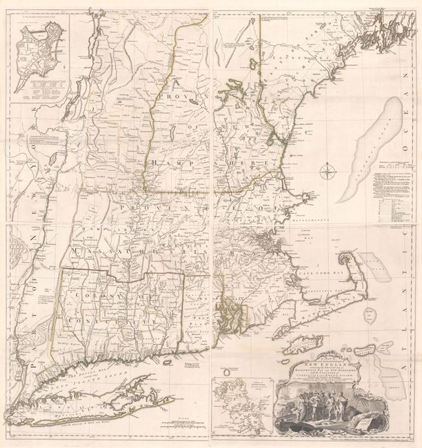
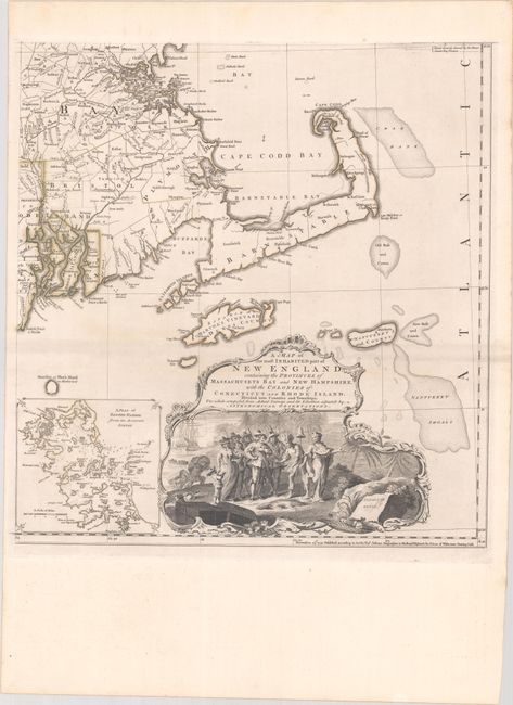
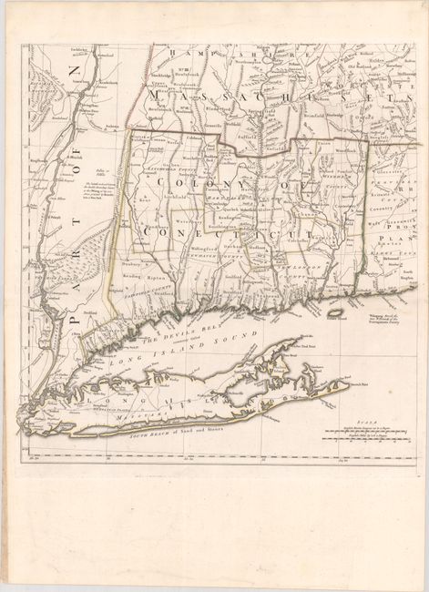
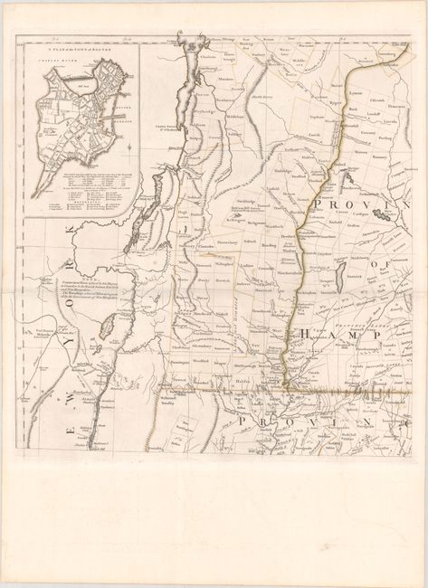
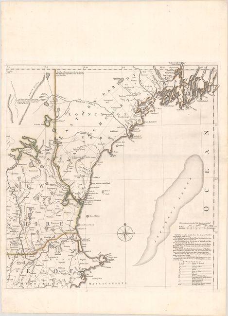
This is the rare fourth state of Jefferys' celebrated map of New England, dated 1755 but published circa 1768. The map was first issued in 1755 at the beginning of the French and Indian War, and it became the most influential map of the region for the next several decades. The map was compiled by Bradock Mead (alias John Green) from influential contemporary sources, primarily Plan of the British Dominions of New England in North America (1753) by Dr. William Douglass. Credit is given to each of the surveys used in a table at right center, although Douglass' map is strangely omitted from the list. Jefferys' map represents the first widely disseminated, large-format depiction of the region and is a significant improvement over the Douglass map, in part because of the additional territory covered and almost certainly the additional information which was likely available to Jefferys and Mead in the several years following the issue of the Douglass map.
The map covers the area from Penobscot Bay to the Hudson River. It shows villages, towns, roads, counties, watershed, mountains and topography, and information along the coast, including islands, bays, and much more. A title cartouche at bottom right incorporates an idealized vignette of the Pilgrims arriving at Plymouth, greeted by a Native American with a liberty cap. Stevens & Tree identify this as the second issue of the second edition of the map. The map was significantly updated circa 1763 with a new inset and geographical changes. Most notably, the area in present-day Vermont and New Hampshire that was previously labeled Wildernes Lands of the Crown not yet appropriated has been revised into a grid of townships. The region's lakes have also been rendered with greater accuracy. This state is distinguished as the second issue of the second edition (or the fourth state) by a note at top left referring to the Connecticut River as the New York-New Hampshire boundary and that the townships in yellow are part of New Hampshire. There are two insets: "A Plan of Boston Harbor" (bottom right) and "A Plan of the Town of Boston" (top left). The latter inset was a replacement for the plan of Fort Frederick that appeared on the first two states of the map. Most of the examples of this map on the market are one of the last two states of the map, published in 1774 and 1794. Given that this state was separately issued and did not appear in one of Jefferys' atlases, it is rarely found on the market. If joined, the map would measure approximately 38.6 x 40.7".
References: McCorkle #755.19; Pritchard & Taliaferro #35; Stevens & Tree (MCC-39) #33(e).
Condition: A
A fine impression with contemporary outline color on paper with Strasbourg Lily watermarks and a few minor spots. The two northern sheets have very short centerfold separations confined to the blank margins. The southwestern sheet has some tiny edge tears at bottom left that have been archivally repaired on verso. Remnants of hinge tape on verso. The first image is a composite image - the map is on four separate sheets.