Subject: Colonial North America
Period: 1730 (circa)
Publication:
Color: Hand Color
Size:
38 x 22.7 inches
96.5 x 57.7 cm
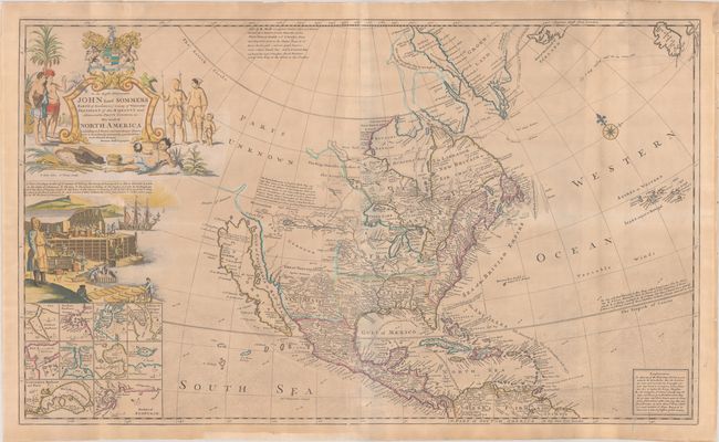
Moll's map of North America was published circa 1720 in response to Delisle's influential map Carte de La Louisiane de du Cours du Mississipi published a couple of years prior. The British hoped to counter Delisle's French claims to the Carolinas with Moll's map, which depicts Newfoundland through the Carolinas under British control and extends British claims to Labrador (New Britain) and the area surrounding Hudson's Bay. In addition, Moll reduces France's claims with Louisiana extending just south of the Ohio River. This is one of the later maps still to show California as an island. California is illustrated with an indented northern coast on the second Sanson model, with New Albion depicted according to Sir Francis Drake and Mozeemleck Country and Straits of Annian to the north. Lahontan's fabled R. Longue and great salt lake of the Gnacsitares appear just east of Mozeemleck Country. The map also shows the tracks of Captain Hudson and Captain James' in their searches for a northwest passage in the early 17th century. Ten insets of harbor plans fill the bottom left corner, including Boston, New York, Charlestown, Port Royal, St. Johns, Acapulco, Cartagena, and Havana.
As with many of Moll's large maps, this map incorporates numerous decorative elements. An elaborate title cartouche dominates the upper left corner with a dedication to the Right Honourable Lord John Somers, an English Whig jurist and statesman who is known for his role in the Bill of Rights in England in 1689. The title is flanked by Indians and Eskimos, tropical birds, and the coat of arms of the Somers family with the Latin motto "Prodesse Quam Conspici" (to Accomplish Rather than to Be Conspicuous). A large vignette below the title illustrates the important cod fishing industry in Newfoundland, which lends this map its nickname as the "Codfish Map." The vignette shows numerous steps within the process, including fishing, carrying, salting, pressing, and drying the fish.
Printed for John Bowles "at the Black Horse in Cornhill," Thomas Bowles, P. Overton, and John King. Printed on two sheets, joined as issued.
References: Goss (NA) #53; McLaughlin #192; Schwartz & Ehrenberg, pl.79; Shirley (BL Atlases) T.MOLL-4b #7; Wheat (TMW) #105.
Condition: B
A crisp impression on lightly toned sheets with an "MW" watermark, issued folding. Fully backed in archival tissue to repair several fold separations and a number of short tears along the edges of the sheets, several of which enter into the image less than 1/2". A chip in the bottom margin has also been repaired. There are a couple of extraneous creases adjacent to the fold at bottom right.