Showing Featured Lots(remove filter)
Showing results for:Auction 187
Catalog Archive
65 lots
Page 1 of 2
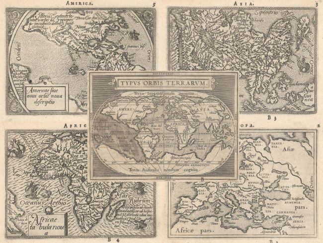
Auction 187, Lot 1
Subject: World & Continents
Ortelius/Galle
[Lot of 5] Typus Orbis Terrarum [and] Americae sive Novi Orbis Nova Descriptio [and] Africae Tabula Nova [and] Asiae Nova Descr: [and] Europa, 1589
Size: 4.3 x 3.1 inches (10.9 x 7.9 cm)
Estimate: $1,400 - $1,700
Matching Set of Miniature Ortelius Maps
Sold for: $1,000
Closed on 4/27/2022
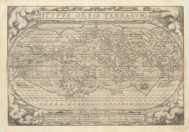
Auction 187, Lot 2
Subject: World
Ortelius, Abraham
Typus Orbis Terrarum, 1571
Size: 19.8 x 13.4 inches (50.3 x 34 cm)
Estimate: $7,000 - $8,500
Ortelius' Famous World Map - First Plate
Sold for: $5,000
Closed on 4/27/2022
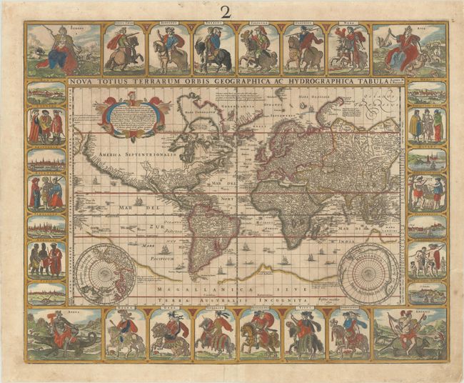
Auction 187, Lot 7
Subject: World
Visscher, Claes Janszoon
Nova Totius Terrarum Orbis Geographica ac Hydrographica Tabula Auctore N. I. Piscator, 1652
Size: 22.3 x 17.9 inches (56.6 x 45.5 cm)
Estimate: $14,000 - $16,000
Visscher's Rare Carte-a-Figures World Map
Sold for: $10,000
Closed on 4/27/2022
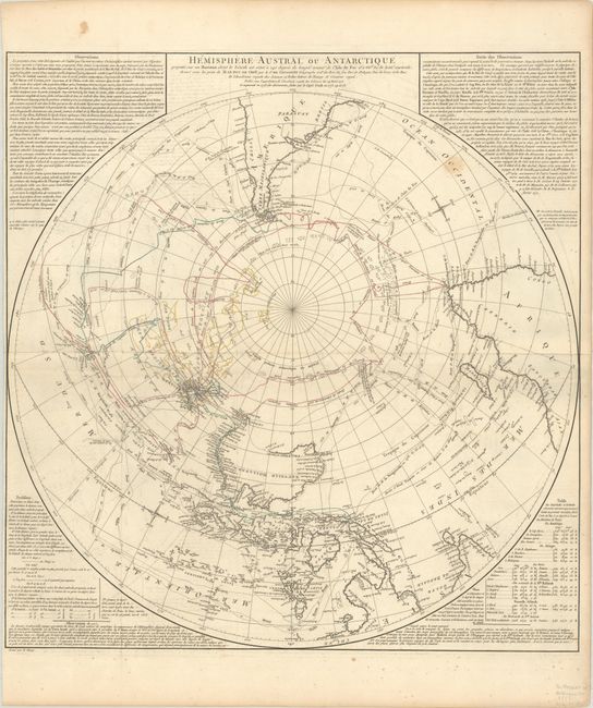
Auction 187, Lot 47
Subject: South Pole
Robert de Vaugondy, Didier
Hemisphere Austral ou Antarctique Projette sur un Horizon dont le Zenith est Situe a 140 Degres de Longit? Orient? de l'Isle de Fer..., 1777
Size: 24.4 x 25.4 inches (62 x 64.5 cm)
Estimate: $4,000 - $5,000
Rare Separately Published Map of New Discoveries in the Southern Hemisphere
Sold for: $2,500
Closed on 4/27/2022
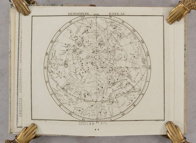
Auction 187, Lot 50
Subject: Celestial Atlas
Flamsteed/Fortin
Atlas Celeste de Flamsteed, Publie en 1776 ... Troisieme Edition..., 1795
Size: 6 x 8.9 inches (15.2 x 22.6 cm)
Estimate: $3,500 - $4,500
Flamsteed's Reduced-Size Atlas with 30 Celestial Plates
Sold for: $1,900
Closed on 4/27/2022
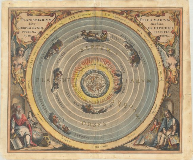
Auction 187, Lot 51
Subject: Solar System
Cellarius, Andreas
Planisphaerium Ptolemaicum, sive Machina Orbium Mundi Ex Hypotheis Ptolemaica in Plano Disposita, 1661
Size: 20.9 x 17.5 inches (53.1 x 44.5 cm)
Estimate: $2,750 - $3,500
Gorgeous Chart Showing Ptolemy's Earth-Centric Model of the Solar System
Sold for: $3,000
Closed on 4/27/2022
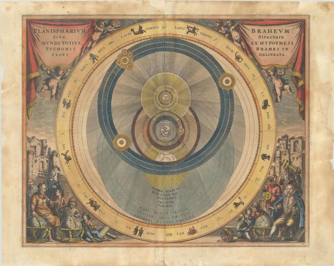
Auction 187, Lot 52
Subject: Solar System
Cellarius, Andreas
Planisphaerium Braheum, sive Structura Mundi Totius, Ex Hypothesi Tychonis Brahei in Plano Descriptio, 1661
Size: 20.4 x 16.6 inches (51.8 x 42.2 cm)
Estimate: $2,000 - $2,750
Decorative Chart Depicting Tycho Brahe's Model of the Universe
Sold for: $1,100
Closed on 4/27/2022

Auction 187, Lot 54
Subject: Orrery, Globe
Philip, George
[Orrery with 3-inch Terrestrial Globe], 1900
Size: 14.5 x 8.8 inches (36.8 x 22.4 cm)
Estimate: $2,000 - $2,500
Superb Model Demonstrating the Movements of the Earth and Moon
Sold for: $3,000
Closed on 4/27/2022
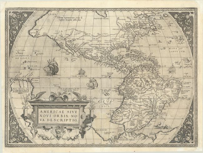
Auction 187, Lot 73
Subject: Western Hemisphere - America
Ortelius, Abraham
Americae sive Novi Orbis, Nova Descriptio, 1571
Size: 20.1 x 14.6 inches (51.1 x 37.1 cm)
Estimate: $5,500 - $6,500
Rare First Plate of Ortelius' Influential Map of the New World
Sold for: $5,000
Closed on 4/27/2022
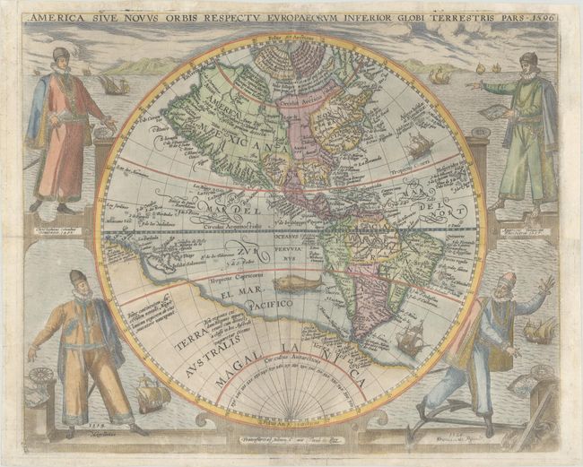
Auction 187, Lot 74
Subject: Western Hemisphere - America
Bry, Theodore de
America sive Novus Orbis Respectu Europaeorum Inferior Globi Terrestris Pars, 1596
Size: 15.7 x 12.8 inches (39.9 x 32.5 cm)
Estimate: $6,000 - $7,500
De Bry's Rare Map of the New World Featuring Explorers
Sold for: $4,250
Closed on 4/27/2022
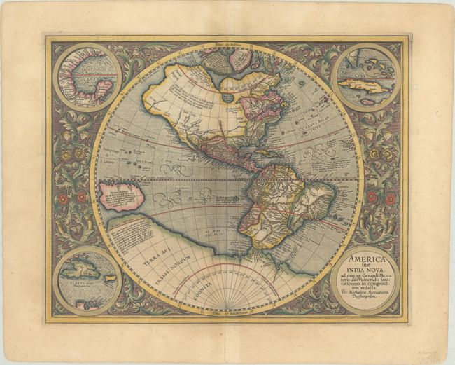
Auction 187, Lot 75
Subject: Western Hemisphere - America
Mercator, Michael
America sive India Nova, ad Magnae Gerardi Mercatoris aui Universalis Imitationem in Compendium Redacta, 1609
Size: 18.1 x 14.4 inches (46 x 36.6 cm)
Estimate: $3,250 - $4,000
Mercator's Foundation Map for the Americas
Sold for: $3,250
Closed on 4/27/2022
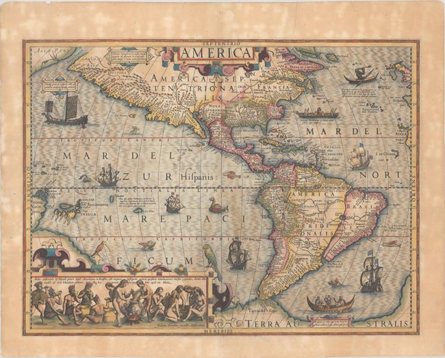
Auction 187, Lot 76
Subject: Western Hemisphere - America
Hondius, Jodocus
America, 1609
Size: 19.6 x 14.6 inches (49.8 x 37.1 cm)
Estimate: $4,000 - $4,750
Hondius' Important Map of the Americas
Sold for: $3,000
Closed on 4/27/2022
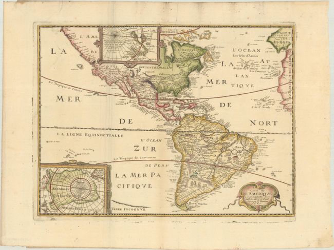
Auction 187, Lot 78
Subject: Western Hemisphere - America
Bertius/Tavernier
Carte de l'Amerique Corrigee et Augmentee; Dessus Toutes les Aultres cy Devant Faictes, 1661
Size: 14.4 x 10.8 inches (36.6 x 27.4 cm)
Estimate: $1,200 - $1,500
Rare Derivative of Hondius' Influential Map
Sold for: $750
Closed on 4/27/2022
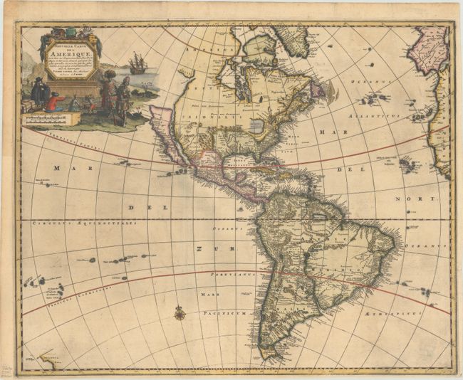
Auction 187, Lot 81
Subject: Western Hemisphere - America
Aa, Pieter van der
Nouvelle Carte de l'Amerique, avec tous ses Royaumes, Etats, Iles, Ports, Bayes et Rivieres, Dressee Suivant les Plus Nouvelles Decouvertes par les Habiles Geographes..., 1714
Size: 21.2 x 17 inches (53.8 x 43.2 cm)
Estimate: $1,400 - $1,700
Uncommon Map with Interesting Geographical Myths
Sold for: $1,300
Closed on 4/27/2022
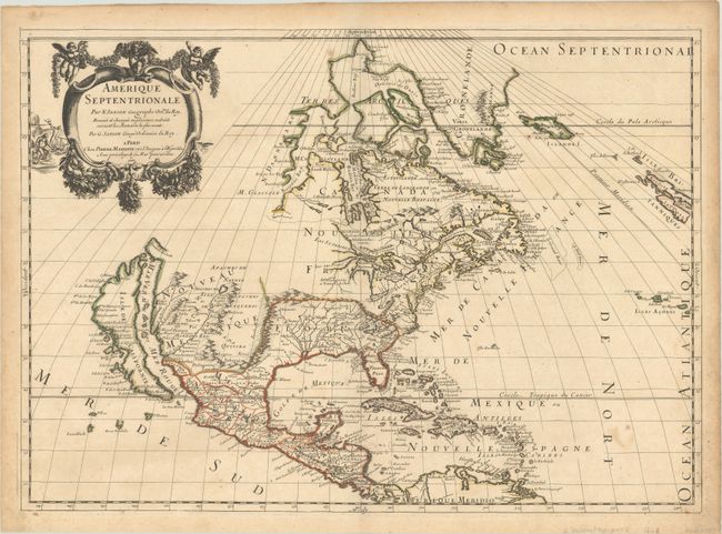
Auction 187, Lot 94
Subject: Colonial North America
Sanson/Mariette
Amerique Septentrionale, 1669
Size: 21.9 x 15.6 inches (55.6 x 39.6 cm)
Estimate: $1,900 - $2,200
Important Map for Great Lakes Collectors
Sold for: $1,400
Closed on 4/27/2022
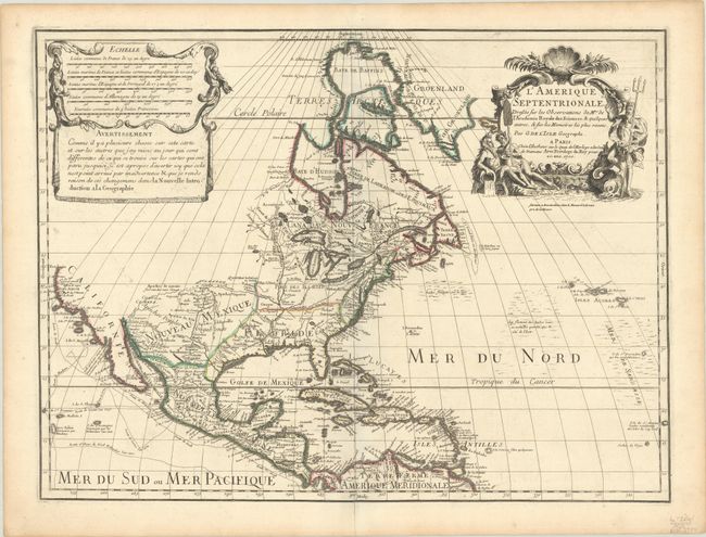
Auction 187, Lot 95
Subject: Colonial North America
Delisle, Guillaume
L'Amerique Septentrionale. Dressee sur les Observations de Mrs. de l'Academie Royale des Sciences, & Quelques Autres..., 1700
Size: 23.9 x 17.9 inches (60.7 x 45.5 cm)
Estimate: $1,900 - $2,200
Delisle's Foundation Map of North America
Sold for: $1,400
Closed on 4/27/2022
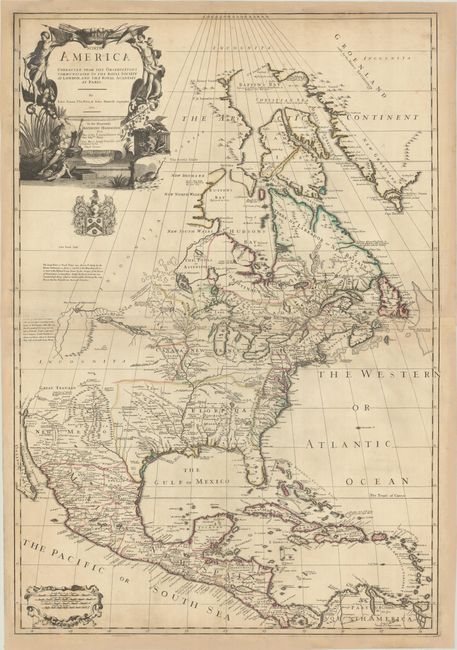
Auction 187, Lot 97
Subject: Colonial North America
Price, Senex & Maxwell
North America Corrected from the Observations Communicated to the Royal Society at London, and the Royal Academy at Paris, 1710
Size: 25.8 x 37.7 inches (65.5 x 95.8 cm)
Estimate: $3,500 - $4,250
First State of One of the Earliest Large-Scale English Maps of North America
Sold for: $2,500
Closed on 4/27/2022
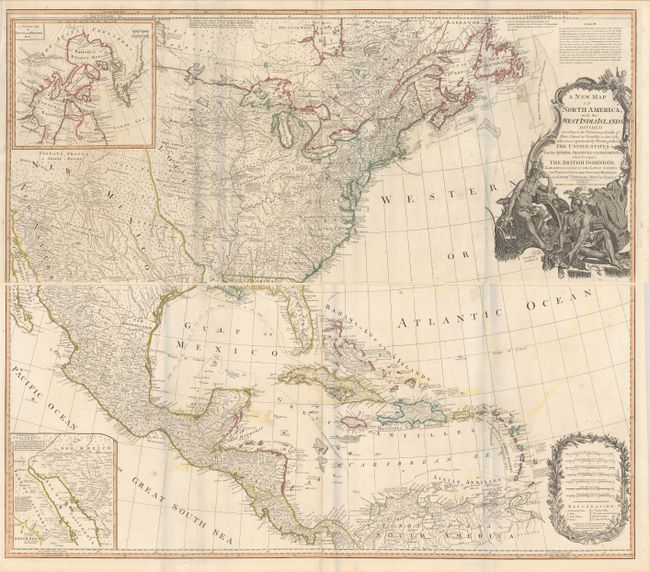
Auction 187, Lot 103
Subject: North America
Laurie & Whittle
[On 4 Sheets] A New Map of North America, with the West India Islands. Divided According to the Preliminary Articles of Peace, Signed at Versailles, 20, Jan. 1783..., 1794
Size: 45.5 x 20 inches (115.6 x 50.8 cm)
Estimate: $2,200 - $2,500
Important Large Map of North America Featuring the Young United States
Sold for: $2,100
Closed on 4/27/2022
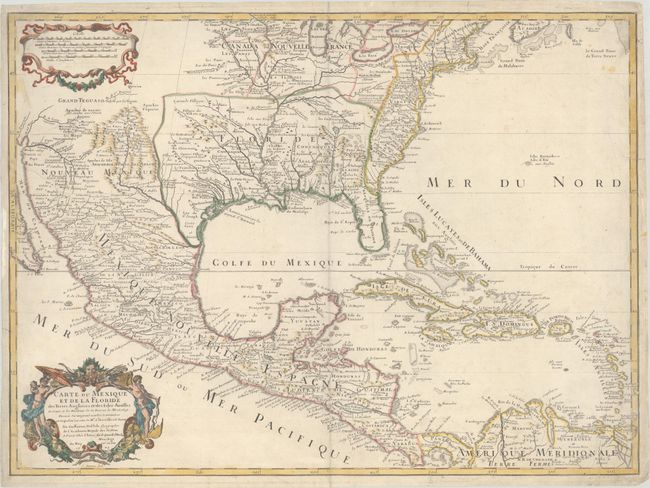
Auction 187, Lot 109
Subject: Colonial Eastern North America & Caribbean
Delisle, Guillaume
Carte du Mexique et de la Floride des Terres Angloises et des Isles Antilles du Cours et des Environs de la Riviere de Mississipi..., 1703
Size: 25.4 x 18.7 inches (64.5 x 47.5 cm)
Estimate: $2,200 - $2,500
Landmark in American Cartography - First Printed Map to Accurately Depict the Mouth of the Mississippi River
Sold for: $1,200
Closed on 4/27/2022
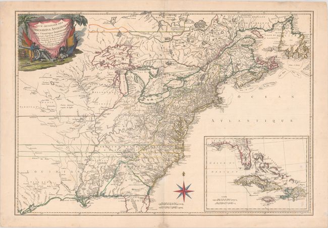
Auction 187, Lot 112
Subject: Colonial Eastern North America & Caribbean
Esnauts & Rapilly
Carte Detaillee des Possessions Angloises dans l'Amerique Septentrionale…, 1777
Size: 29.8 x 20.5 inches (75.7 x 52.1 cm)
Estimate: $3,750 - $4,500
Rare First State of French Map Showing Theater of War During American Revolution
Sold for: $2,750
Closed on 4/27/2022
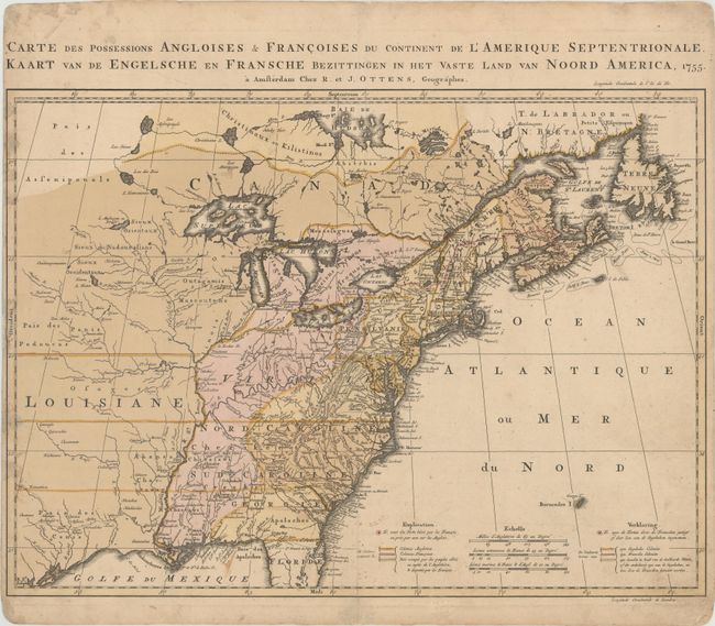
Auction 187, Lot 122
Subject: Colonial Eastern United States & Canada
Ottens, Reiner and Joshua
Carte des Possessions Angloises & Francoises du Continent de l'Amerique Septentrionale / Kaart van de Engelsche en Fransche Bezittingen in het Vaste Land van Noord America, 1755
Size: 22.4 x 16.3 inches (56.9 x 41.4 cm)
Estimate: $1,400 - $1,700
Dutch Version of an Important Map Showing Territorial Claims at the Outset of the French and Indian War
Sold for: $1,300
Closed on 4/27/2022
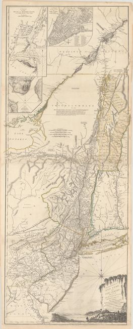
Auction 187, Lot 130
Subject: Colonial Northeastern United States & Quebec
Holland/Pownal
The Provinces of New York and New Jersey; with Part of Pensilvania, and the Province of Quebec, 1776
Size: 21.3 x 52.9 inches (54.1 x 134.4 cm)
Estimate: $4,000 - $4,750
Thomas Jefferys' Important Revolutionary War Period Map
Unsold
Closed on 4/27/2022
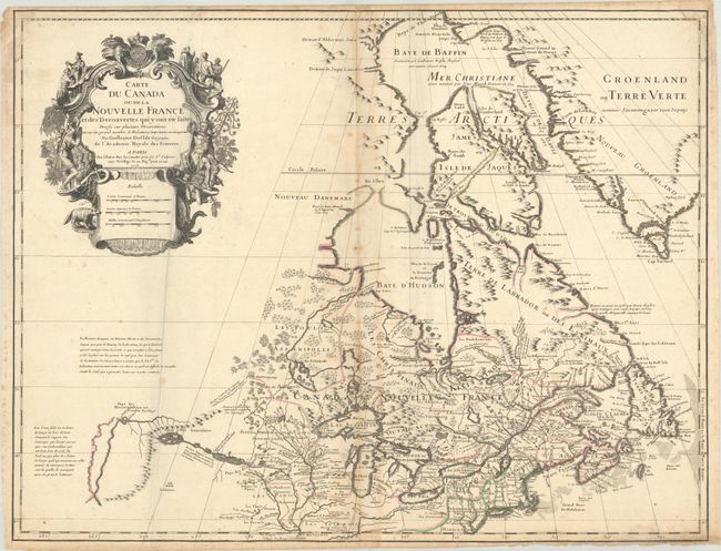
Auction 187, Lot 131
Subject: Colonial Northeastern United States & Canada, Great Lakes
Delisle, Guillaume
Carte du Canada ou de la Nouvelle France et des Decouvertes qui y ont ete Faites Dressee sur Plusieurs Observations et sur un Grand Nombre de Relations Imprimees ou Manuscrites, 1703
Size: 25.6 x 19.8 inches (65 x 50.3 cm)
Estimate: $3,000 - $3,750
Rare First State of Delisle's Seminal Map of Canada and the Great Lakes
Sold for: $4,750
Closed on 4/27/2022
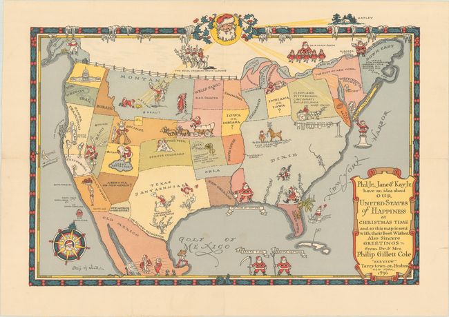
Auction 187, Lot 145
Subject: United States
Phil Jr., Jane & Kay Jr. Have an Idea About Our United States of Happiness at Christmas Time..., 1936
Size: 13.9 x 9.8 inches (35.3 x 24.9 cm)
Estimate: $600 - $800
Christmas Map Combining Santa and the American West, Commissioned by Philip Cole
Sold for: $475
Closed on 4/27/2022
Auction 187, Lot 156
Subject: Eastern United States
Tardieu, Pierre Francois
[On 4 Sheets] United States of Nth America - Carte des Etats-Unis de l'Amerique Septentrionale Copiee et Gravee sur celle d'Arrowsmith..., 1802
Size: 55.2 x 49.2 inches (140.2 x 125 cm)
Estimate: $4,000 - $5,000
Rare French Edition of Arrowsmith's Influential Map of the United States
Sold for: $2,000
Closed on 4/27/2022
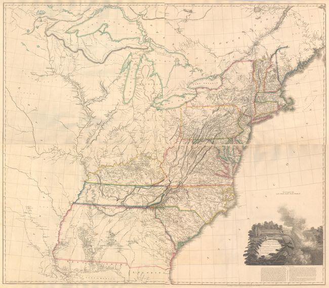
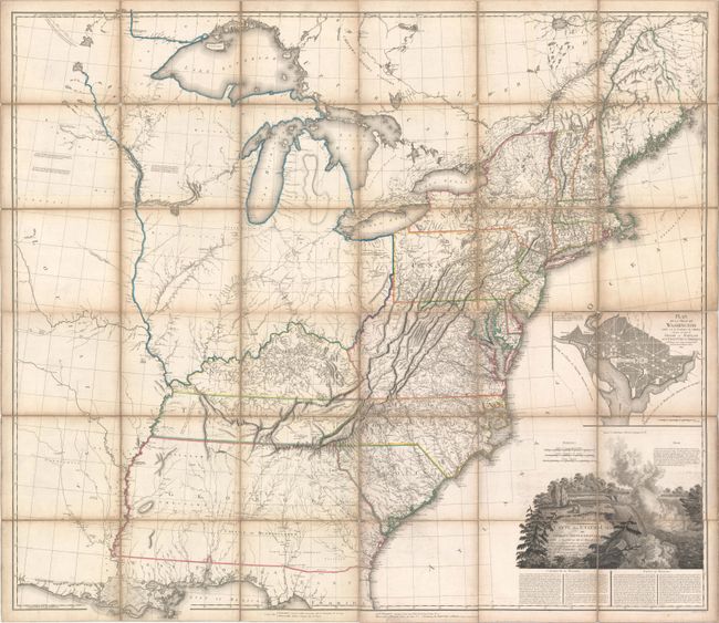
Auction 187, Lot 160
Subject: Eastern United States
Arrowsmith, Aaron, Sr.
[On 4 Sheets] A Map of the United States of North America Drawn from a Number of Critical Researches, 1815
Size: 27.8 x 24.3 inches (70.6 x 61.7 cm)
Estimate: $7,500 - $9,000
Large Format Map Used by Lewis & Clark
Unsold
Closed on 4/27/2022
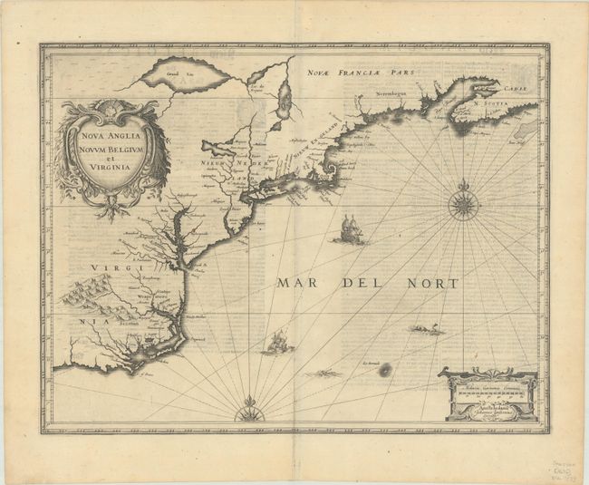
Auction 187, Lot 167
Subject: Colonial New England & Mid-Atlantic United States
Jansson, Jan
Nova Anglia Novum Belgium et Virginia, 1636
Size: 19.9 x 15.3 inches (50.5 x 38.9 cm)
Estimate: $1,100 - $1,400
Jansson's Influential Map of the East Coast
Sold for: $800
Closed on 4/27/2022
Auction 187, Lot 174
Subject: New England United States
Crevecoeur, Michel Guillaume De
[Three Volumes] Lettres d'un Cultivateur Americain Addressees a Wm. S... on Esqr. Depuis l'Annee 1770 Jusqu'en 1786..., 1787
Size: 5.1 x 8.1 inches (13 x 20.6 cm)
Estimate: $3,250 - $4,000
Crevecoeur's Classic Account on American Life
Sold for: $3,500
Closed on 4/27/2022
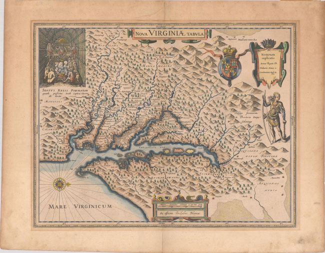
Auction 187, Lot 177
Subject: Colonial Mid-Atlantic United States
Hondius/Blaeu
Nova Virginiae Tabula, 1640
Size: 18.9 x 14.8 inches (48 x 37.6 cm)
Estimate: $1,800 - $2,100
One of the Most Important 17th Century Maps of the Chesapeake Bay
Sold for: $1,100
Closed on 4/27/2022
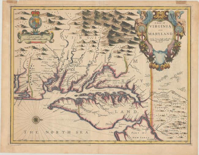
Auction 187, Lot 179
Subject: Colonial Mid-Atlantic United States
Speed/Lamb
A Map of Virginia and Maryland, 1676
Size: 19.4 x 14.9 inches (49.3 x 37.8 cm)
Estimate: $4,750 - $6,000
The First Printed Map to Draw Upon the Legendary Herrman Map of the Chesapeake Bay - Previously Owned by Coolie Verner
Unsold
Closed on 4/27/2022
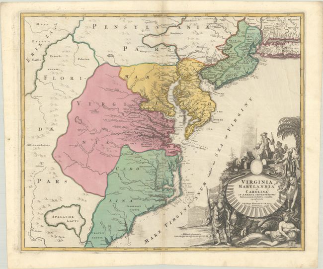
Auction 187, Lot 180
Subject: Colonial Mid-Atlantic United States
Homann, Johann Baptist
Virginia Marylandia et Carolina in America Septentrionali Britannorum Industria Excultae Repraesentatae, 1730
Size: 22.8 x 19.2 inches (57.9 x 48.8 cm)
Estimate: $1,500 - $1,800
Map Created to Promote German Immigration to the New World
Sold for: $1,100
Closed on 4/27/2022
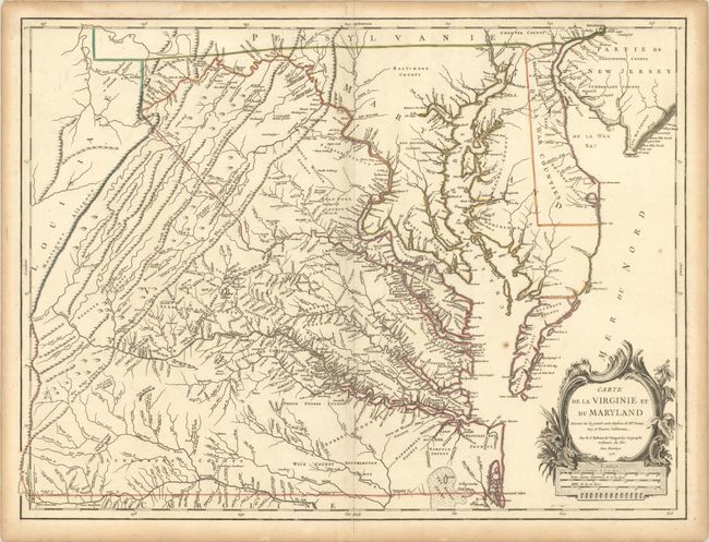
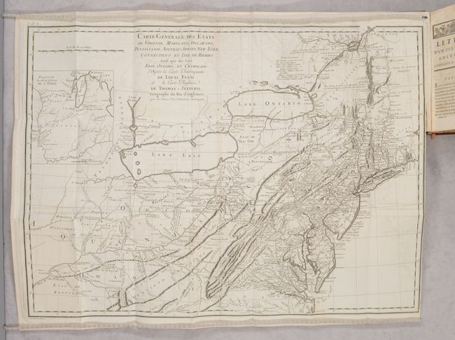
Auction 187, Lot 182
Subject: Colonial Mid-Atlantic United States
Robert de Vaugondy, Didier
Carte de la Virginie et du Maryland Dressee sur la Grande Carte Angloise de Mrs. Josue Fry et Pierre Jefferson, 1755
Size: 25.3 x 19.1 inches (64.3 x 48.5 cm)
Estimate: $2,200 - $2,500
First State of Robert de Vaugondy's Essential Map of Virginia and Maryland
Sold for: $2,300
Closed on 4/27/2022
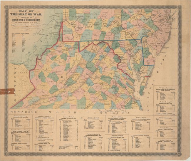
Auction 187, Lot 186
Subject: Mid-Atlantic United States, Civil War
Bridgens, H.F.
Map of the Seat of War, Exhibiting All the Important Positions of the Surrounding Country, and Approaches by Rail Road..., 1861
Size: 23 x 19.7 inches (58.4 x 50 cm)
Estimate: $300 - $400
Rare Civil War Map Listing the "Union Counties of West Virginia"
Sold for: $550
Closed on 4/27/2022
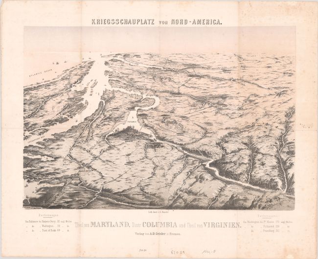
Auction 187, Lot 187
Subject: Mid-Atlantic United States, Civil War
Theil von Maryland, Distr. Columbia und Theil von Virginien, 1862
Size: 19.5 x 13.3 inches (49.5 x 33.8 cm)
Estimate: $1,200 - $1,500
Scarce Bird's-Eye View of Washington and Vicinity
Sold for: $900
Closed on 4/27/2022
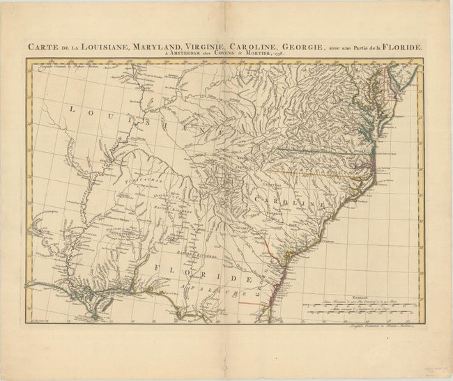
Auction 187, Lot 192
Subject: Colonial Southeast United States
Covens & Mortier
Carte de la Louisiane, Maryland, Virginie, Caroline, Georgie, avec une Partie de la Floride, 1758
Size: 23.1 x 15.4 inches (58.7 x 39.1 cm)
Estimate: $1,100 - $1,400
Covens & Mortier's Map of the Southeast Issued During the French and Indian War
Sold for: $750
Closed on 4/27/2022
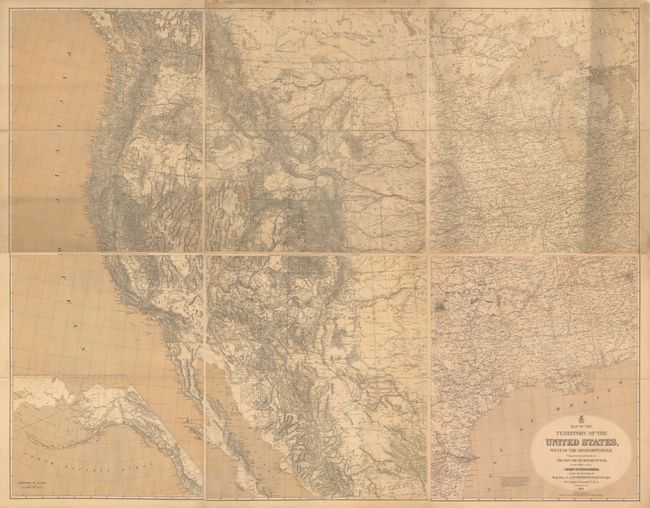
Auction 187, Lot 203
Subject: Western United States
U.S. Army
[On 6 Sheets] Map of the Territory of the United States, West of the Mississippi River. Prepared by Authority of the Hon. the Secretary of War..., 1879
Size: 26.5 x 31.3 inches (67.3 x 79.5 cm)
Estimate: $3,500 - $4,250
Freyhold's Updated & Enlarged Version of Warren's General Map
Sold for: $14,500
Closed on 4/27/2022
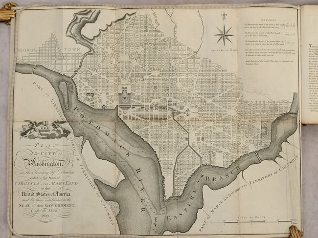
Auction 187, Lot 231
Subject: Washington, D.C.
Russell, John C.
Plan of the City of Washington in the Territory of Columbia... [bound in] An Historical Geographical, Commercial, and Philosophical View of the American United States, and of the European Settlements in America and the West-Indies... Vol. III, 1795
Size: 5.3 x 8.5 inches (13.5 x 21.6 cm)
Estimate: $2,300 - $2,750
Uncommon, Early Large-Format Map of Washington D.C.
Sold for: $1,200
Closed on 4/27/2022
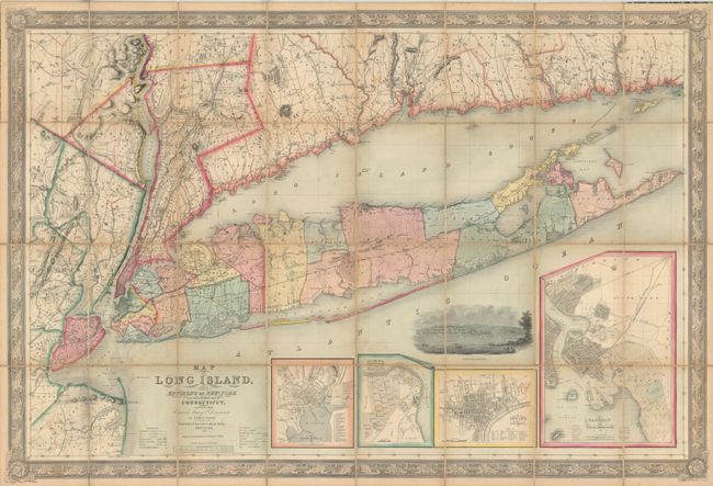
Auction 187, Lot 260
Subject: Long Island, New York
Smith, J. Calvin
Map of Long Island, with the Environs of New-York and the Southern Part of Connecticut, Compiled from Various Surveys & Documents, 1856
Size: 56.3 x 38 inches (143 x 96.5 cm)
Estimate: $2,400 - $3,000
Large-Scale Map of Long Island
Sold for: $2,300
Closed on 4/27/2022
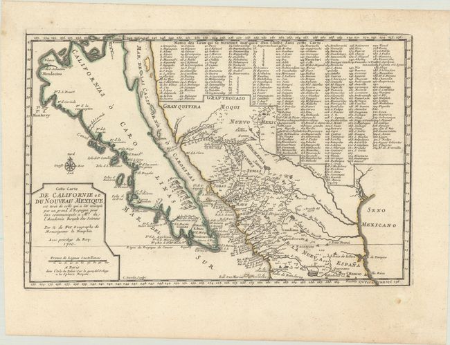
Auction 187, Lot 298
Subject: Southwestern United States & Mexico, California
Fer, Nicolas de
Cette Carte de Californie et du Nouveau Mexique, est Tiree de Celle qui a ete Envoyee par un Grand d'Espagne..., 1700
Size: 13.4 x 8.8 inches (34 x 22.4 cm)
Estimate: $1,200 - $1,500
De Fer's Important Map of the Island of California
Sold for: $900
Closed on 4/27/2022
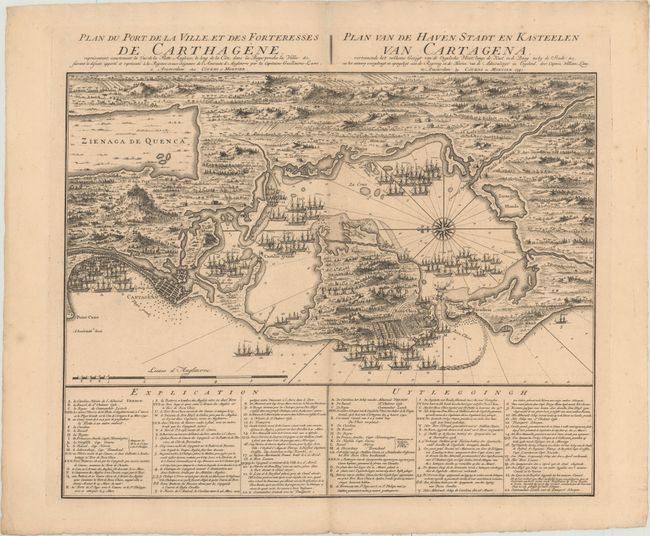
Auction 187, Lot 335
Subject: Cartagena, Colombia
Covens & Mortier
Plan du Port de la Ville, et des Forteresses de Carthagene... / Plan van de Haven, Stadt en Kasteelen van Cartagena..., 1741
Size: 22.4 x 17.8 inches (56.9 x 45.2 cm)
Estimate: $800 - $1,000
Scarce Plan of English Siege of Cartagena During War of Jenkins' Ear
Sold for: $650
Closed on 4/27/2022
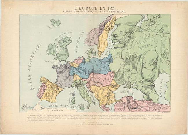
Auction 187, Lot 382
Subject: Europe
L'Europe en 1871 Carte Psychologique..., 1871
Size: 19.7 x 12.8 inches (50 x 32.5 cm)
Estimate: $1,200 - $1,500
Satirical Anthropomorphic Map Illustrating End of Franco-Prussian War
Sold for: $900
Closed on 4/27/2022
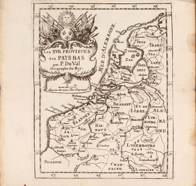
Auction 187, Lot 426
Subject: Low Countries, Atlases
Duval, Pierre
[Two Atlases in One Book] Cartes et Tables de Geographie, des Provinces Eschues a la Reine Tres-Chretiene [and] Les XII. Provinces. Ou sont les Conquestes du Roy en Holande, et en Flandres, 1672
Size: 3.6 x 6 inches (9.1 x 15.2 cm)
Estimate: $1,400 - $1,700
Two Miniature Atlases of Louis XIV's Attempts to Conquer the Spanish Netherlands
Unsold
Closed on 4/27/2022
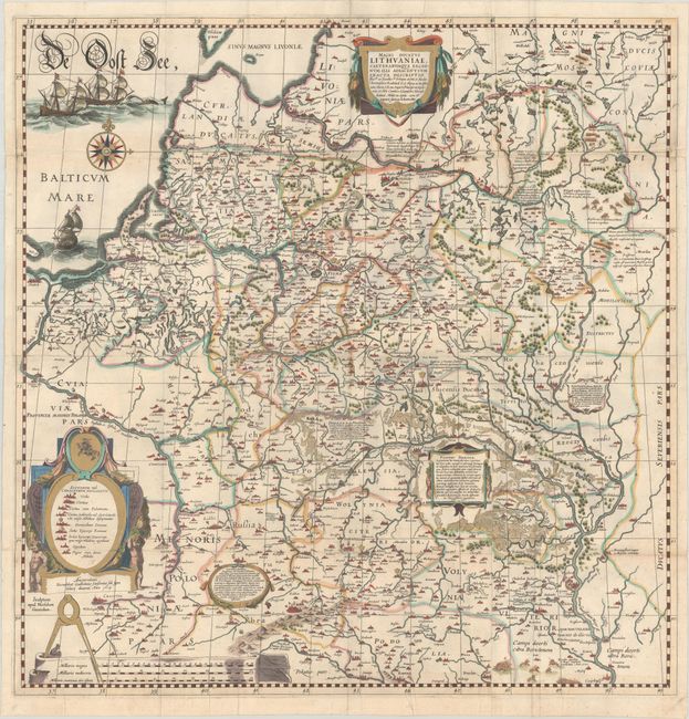
Auction 187, Lot 499
Subject: Eastern Europe, Lithuania & Ukraine
Blaeu, Willem
Magni Ducatus Lithuaniae, Caeterarumque Regionum Illi Adiacentium Exacta Descriptio..., 1634
Size: 28.9 x 29.6 inches (73.4 x 75.2 cm)
Estimate: $3,500 - $4,250
Impressive Wall Map of the Grand Duchy of Lithuania
Sold for: $3,250
Closed on 4/27/2022
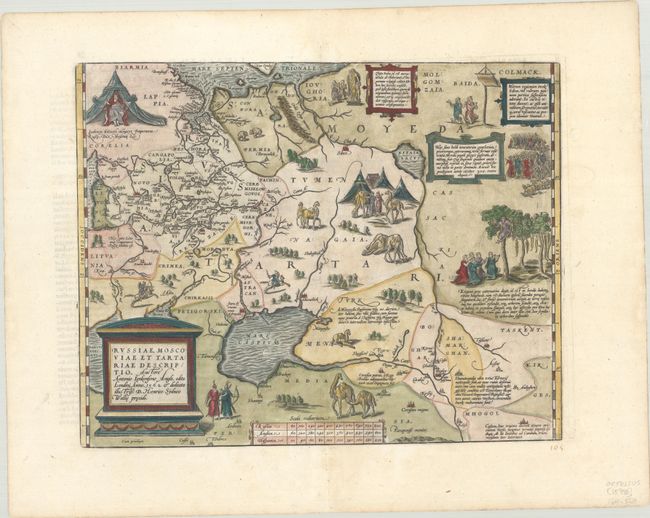
Auction 187, Lot 502
Subject: Russia, Eastern Europe & Central Asia
Ortelius, Abraham
Russiae, Moscoviae et Tartariae Descriptio. Auctore Antonio Ienkensono Anglo..., 1598
Size: 17.8 x 14 inches (45.2 x 35.6 cm)
Estimate: $2,000 - $2,300
Ortelius' Map of Russia with a Vignette of Ivan the Terrible
Sold for: $1,300
Closed on 4/27/2022
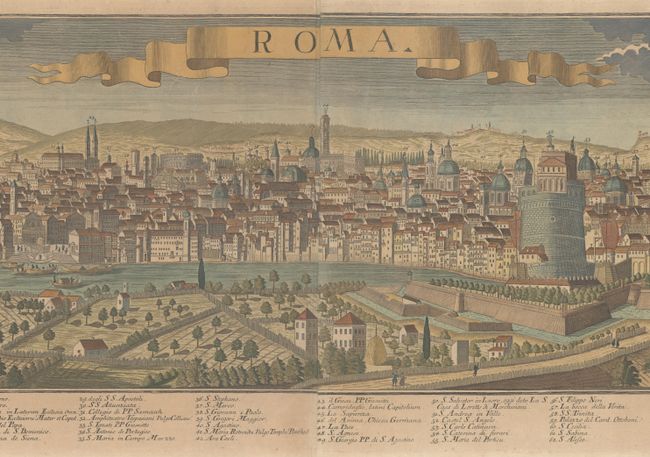
Auction 187, Lot 541
Subject: Rome, Italy
Werner, Friedrich Bernhard
Roma, 1745
Size: 43 x 11.6 inches (109.2 x 29.5 cm)
Estimate: $1,600 - $1,900
Werner's Beautiful Panoramic View of Rome
Sold for: $1,200
Closed on 4/27/2022
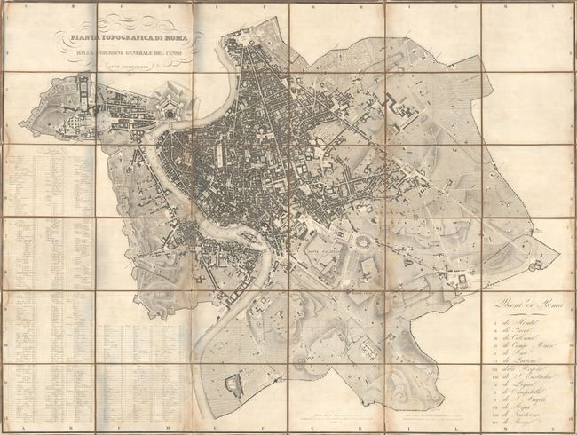
Auction 187, Lot 542
Subject: Rome, Italy
Pianta Topografica di Roma Dalla Direzione Generale del Censo, 1829
Size: 63.1 x 47.1 inches (160.3 x 119.6 cm)
Estimate: $2,000 - $2,300
Rare, Wall-Sized Bird's-Eye Plan of Rome
Unsold
Closed on 4/27/2022
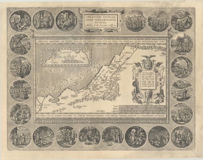
Auction 187, Lot 575
Subject: Holy Land
Ortelius, Abraham
Abrahami Patriarchae Peregrinatio, et Vita, 1586
Size: 18.4 x 14.1 inches (46.7 x 35.8 cm)
Estimate: $1,100 - $1,400
Elaborate Map of the Holy Land, Illustrating the Life of Abraham
Unsold
Closed on 4/27/2022
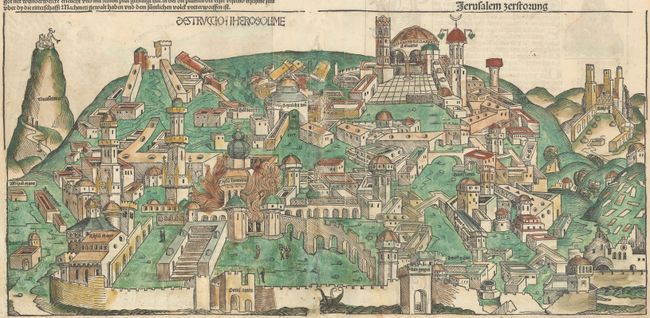
Auction 187, Lot 585
Subject: Jerusalem, Holy Land
Schedel, Hartmann
Destruccio Iherosolime, 1493
Size: 21.6 x 10.2 inches (54.9 x 25.9 cm)
Estimate: $950 - $1,200
Schedel's Woodcut View of Jerusalem
Sold for: $700
Closed on 4/27/2022
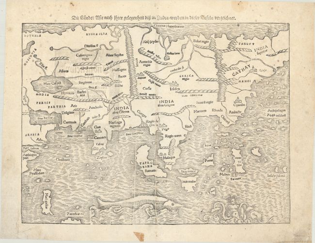
Auction 187, Lot 600
Subject: Asia
Munster, Sebastian
Die Lander Asie nach Ihrer Gelegenheit bisz in India/ Werden in Dieser Tafeln Verzeichnet, 1578
Size: 13.5 x 10.1 inches (34.3 x 25.7 cm)
Estimate: $950 - $1,200
One of the Earliest Maps of the Whole Continent of Asia
Sold for: $850
Closed on 4/27/2022
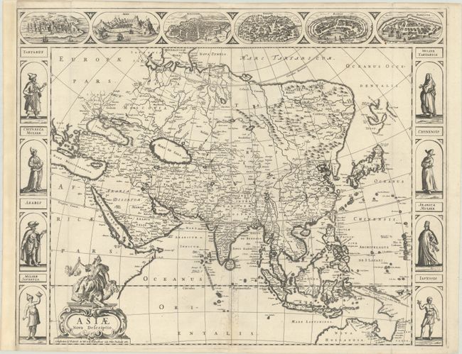
Auction 187, Lot 601
Subject: Asia
Wit, Frederick de
Asiae Nova Descriptio, 1660
Size: 22.2 x 17.4 inches (56.4 x 44.2 cm)
Estimate: $1,600 - $1,900
De Wit's Carte-a-Figures Map of Asia
Sold for: $1,200
Closed on 4/27/2022
65 lots
Page 1 of 2