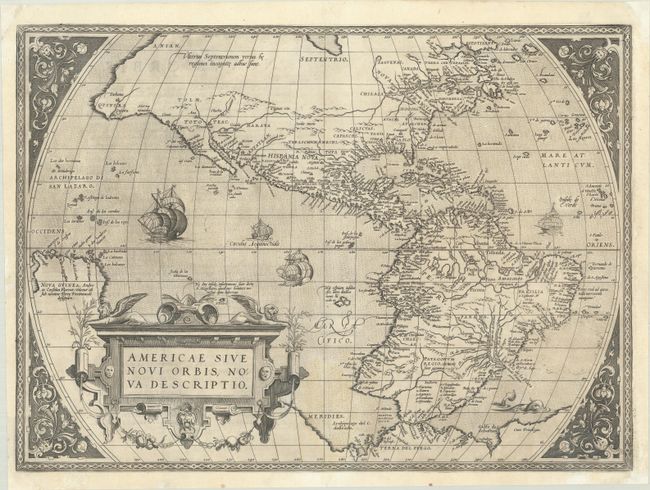
Subject: Western Hemisphere - America
Period: 1571 (published)
Publication: Theatrum Orbis Terrarum
Color: Black & White
Size:
20.1 x 14.6 inches
51.1 x 37.1 cm
This is one of the most famous maps of America, and one that had enormous influence on the future cartography of the New World. Frans Hogenberg engraved this map, and it is primarily based on Gerard Mercator's great multi-sheet world map of 1569. The most recognizable features of the map are the bulbous Chilean coastline and the exaggerated breadth of the North American continent. North America shows a lengthy St. Lawrence River reaching across the continent to nearly meet the fictitious, westward flowing Tiguas Rio. The strategically placed title cartouche hides the unknown South Pacific and therefore most of the conjectural great southern continent, which is shown attached to both New Guinea and Tierra del Fuego.
This is from the uncommon first plate (second state), published in the second Latin edition of 1571. This plate had a relatively short life and was published only between 1570 and 1575.
References: Burden #39.2; Goss (NA) #11; Van den Broecke #9.2.
Condition: A
A dark, early impression on a sheet with a small coat of arms watermark, a faint stain at bottom center, and light printer's ink residue. There are professional repairs to a few small wormholes in the image with a couple of tiny stipple marks replaced in facsimile, as well as repairs to several small chips and tears confined to the blank margins.