Showing Featured Lots(remove filter)
Showing results for:Auction 170
Catalog Archive
74 lots
Page 1 of 2
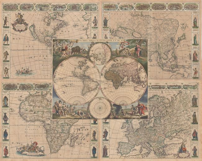
Auction 170, Lot 7
Subject: World & Continents
Wit, Frederick de
[Lot of 5] Nova Orbis Tabula, in Lucem Edita [and] Nova Totius Americae Descriptio [and] Asiae Nova Descriptio [and] Nova Africa Descriptio [and] Nova Europae Descriptio, 1660-70
Size: See Description
Estimate: $11,000 - $13,000
A Stunning Set of Carte-a-Figures Maps
Unsold
Closed on 11/14/2018
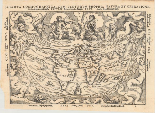
Auction 170, Lot 9
Subject: World
Apianus, Peter Bienewitz
Charta Cosmographica, cum Ventorum Propria Natura et Operatione, 1553
Size: 10.8 x 7.4 inches (27.4 x 18.8 cm)
Estimate: $4,000 - $4,750
Apianus' Popular Cordiform World Map
Sold for: $2,750
Closed on 11/14/2018
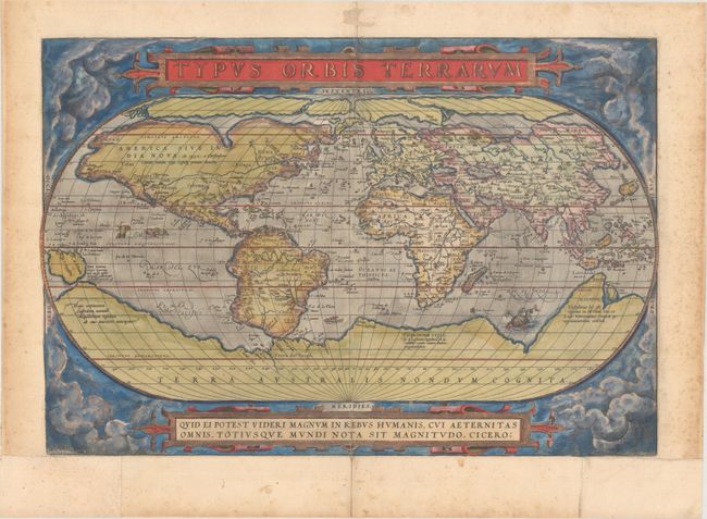
Auction 170, Lot 11
Subject: World
Ortelius, Abraham
Typus Orbis Terrarum, 1571
Size: 19.7 x 13.3 inches (50 x 33.8 cm)
Estimate: $5,500 - $6,500
Ortelius' Famous World Map - First Plate
Sold for: $4,000
Closed on 11/14/2018
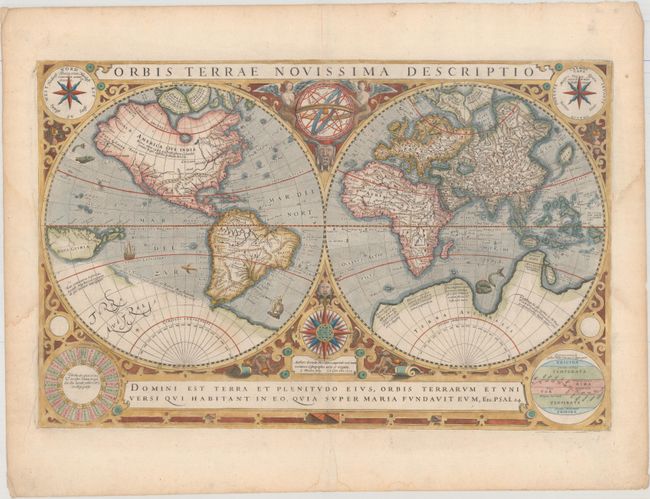
Auction 170, Lot 12
Subject: World
Hondius/Le Clerc
Orbis Terrae Novissima Descriptio, 1633
Size: 19.9 x 12.9 inches (50.5 x 32.8 cm)
Estimate: $5,500 - $6,500
Le Clerc's Decorative World Map Engraved by Hondius
Unsold
Closed on 11/14/2018
Auction 170, Lot 13
Subject: World
Camoens, Luis de
[Untitled - World], 1639
Size: 15.4 x 7.8 inches (39.1 x 19.8 cm)
Estimate: $4,750 - $6,000
A Scarce Spanish World Map
Unsold
Closed on 11/14/2018
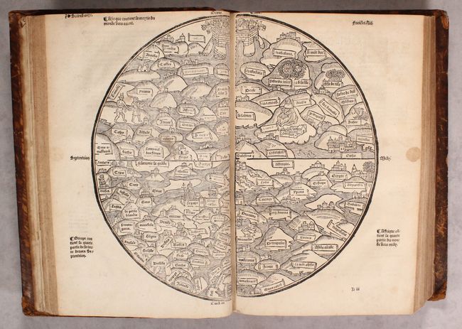
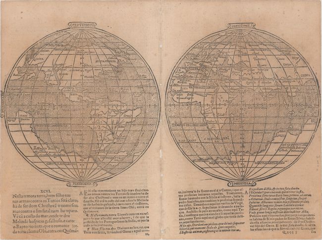
Auction 170, Lot 45
Subject: Ancient World & Holy Land
[Ancient World & Palestine Maps in book] La Mer des Histoires..., 1543
Size: 13.5 x 9.3 inches (34.3 x 23.6 cm)
Estimate: $28,000 - $35,000
Rare Medieval Maps of the World and Palestine
Unsold
Closed on 11/14/2018
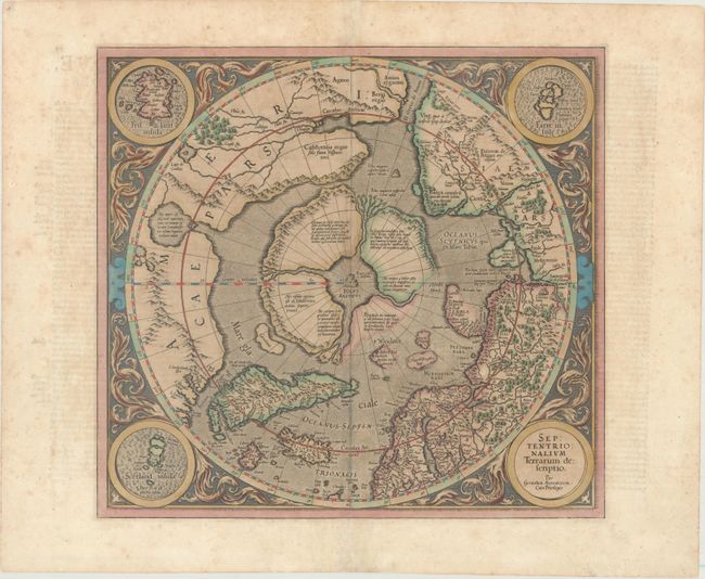
Auction 170, Lot 50
Subject: North Pole
Mercator/Hondius
Septentrionalium Terrarum Descriptio, 1628
Size: 15.6 x 14.6 inches (39.6 x 37.1 cm)
Estimate: $2,000 - $2,300
The First Printed Map Devoted to the Arctic
Sold for: $1,500
Closed on 11/14/2018
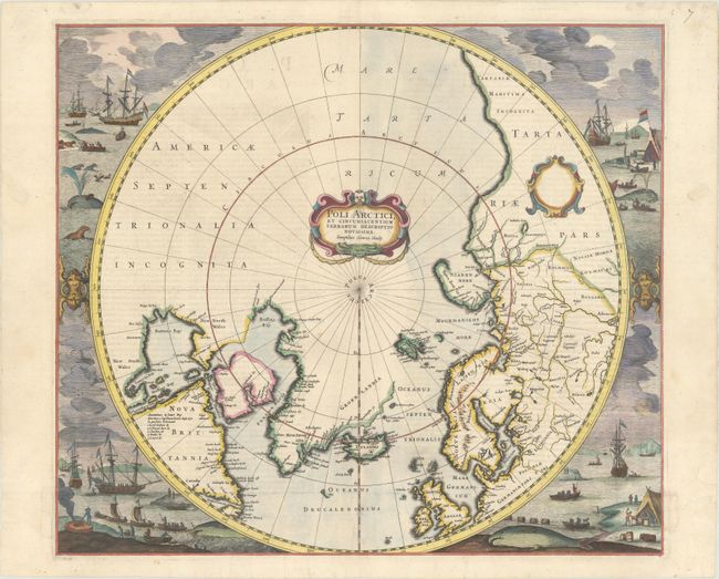
Auction 170, Lot 51
Subject: North Pole
Hondius, Henricus
Poli Arctici, et Circumiacentium Terrarum Descriptio Novissima, 1637
Size: 19.4 x 17 inches (49.3 x 43.2 cm)
Estimate: $2,200 - $2,500
Magnificent Polar Map Surrounded by Whaling Scenes
Sold for: $1,350
Closed on 11/14/2018
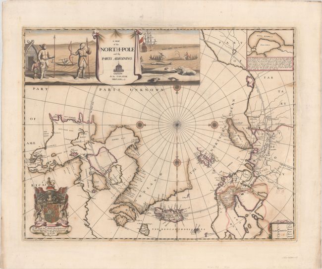
Auction 170, Lot 53
Subject: North Pole
Pitt, Moses
A Map of the North-Pole and the Parts Adioining, 1680
Size: 23.1 x 18 inches (58.7 x 45.7 cm)
Estimate: $3,000 - $3,750
Beautiful English Map of the North Pole
Unsold
Closed on 11/14/2018
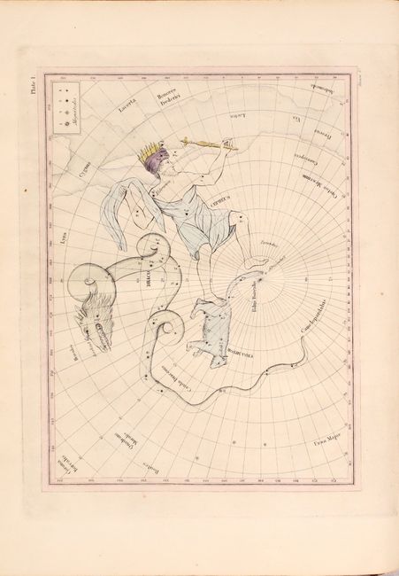
Auction 170, Lot 58
Subject: Celestial Atlas
Finley, Anthony
Astronomical Recreations: or Sketches of the Relative Position and Mythological History of the Constellations, 1824
Size: 8.8 x 11 inches (22.4 x 27.9 cm)
Estimate: $1,600 - $2,000
An Early American Celestial Atlas
Sold for: $1,100
Closed on 11/14/2018
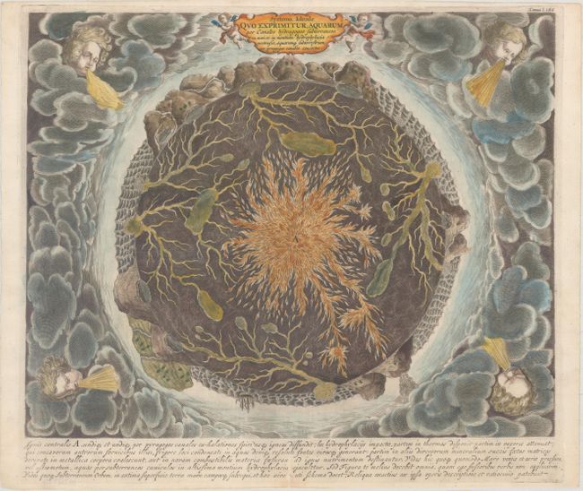
Auction 170, Lot 63
Subject: Cartographic Miscellany, Earth
Kircher, Athanasius
Systema Ideale quo Exprimitur, Aquarum per Canales Hydragogos Subterraneos ex Mari et in Montium Hydrophylacia..., 1682
Size: 16 x 12.9 inches (40.6 x 32.8 cm)
Estimate: $1,600 - $1,900
Fascinating Cross-Section of the Earth
Unsold
Closed on 11/14/2018
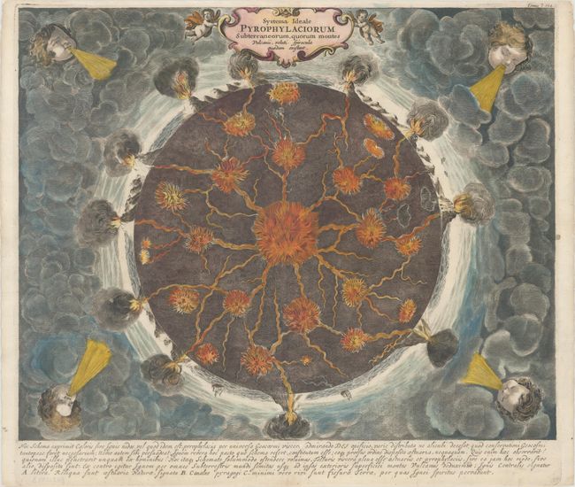
Auction 170, Lot 64
Subject: Cartographic Miscellany, Earth
Kircher, Athanasius
Systema Ideale Pyrophylaciorum Subterraneorum, Quorum Montes Vulcanii, Veluti Spiracula Quaedam Existant, 1682
Size: 16.2 x 13.1 inches (41.1 x 33.3 cm)
Estimate: $1,600 - $1,900
Fascinating Cross-Section of the Earth's Interior
Sold for: $1,100
Closed on 11/14/2018
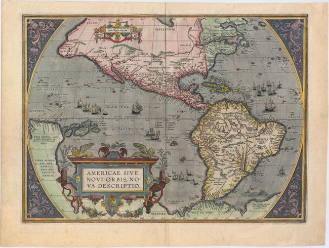
Auction 170, Lot 69
Subject: Western Hemisphere - America
Ortelius, Abraham
Americae sive Novi Orbis, Nova Descriptio, 1587
Size: 19.2 x 14 inches (48.8 x 35.6 cm)
Estimate: $6,000 - $7,500
Ortelius' Influential Map of the New World
Sold for: $4,500
Closed on 11/14/2018
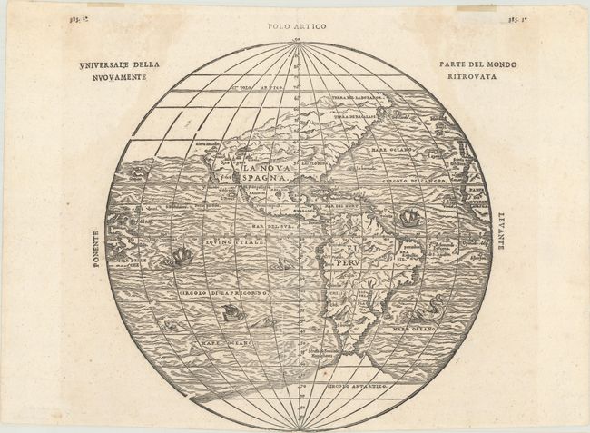
Auction 170, Lot 71
Subject: Western Hemisphere - America
Gastaldi/Ramusio
Universale Della Parte del Mondo Nuovamente Ritrovata, 1606
Size: 10.5 x 10.6 inches (26.7 x 26.9 cm)
Estimate: $3,500 - $4,250
The First Printed Map to Reflect Coronado's Explorations in the Southwest
Sold for: $2,500
Closed on 11/14/2018
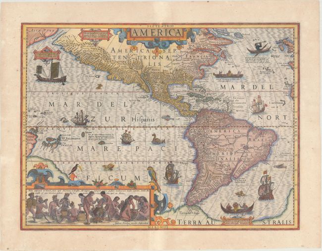
Auction 170, Lot 72
Subject: Western Hemisphere - America
Hondius, Jodocus
America, 1623
Size: 19.7 x 14.7 inches (50 x 37.3 cm)
Estimate: $3,500 - $4,250
Hondius' Important Map of the Americas
Sold for: $1,900
Closed on 11/14/2018
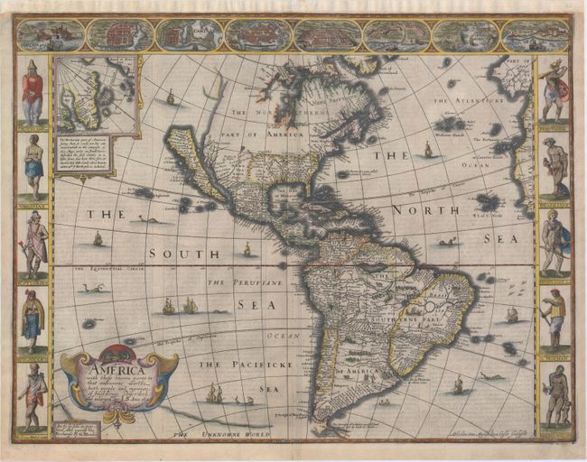
Auction 170, Lot 73
Subject: Western Hemisphere - America
Speed, John
America with Those Known Parts in That Unknowne Worlde Both People and Manner of Buildings Discribed and Inlarged, 1626
Size: 20.3 x 15.4 inches (51.6 x 39.1 cm)
Estimate: $7,500 - $9,000
Speed's Popular Carte-a-Figures Map of the Americas - First State
Sold for: $5,500
Closed on 11/14/2018
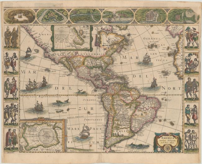
Auction 170, Lot 75
Subject: Western Hemisphere - America
Hondius/Jansson
America Noviter Delineata, 1645
Size: 21.9 x 16.3 inches (55.6 x 41.4 cm)
Estimate: $7,000 - $8,500
Jansson's Rare Carte-a-Figures Map of the Americas in Full Original Color
Unsold
Closed on 11/14/2018
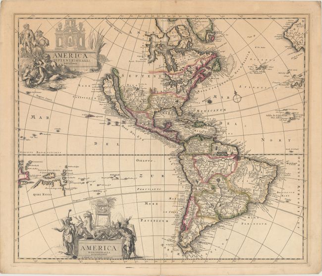
Auction 170, Lot 79
Subject: Western Hemisphere - America
Schenk, Pierre
America Septentrionalis. Novissima / America Meridionalis. Accuratissima, 1695
Size: 22.1 x 18.8 inches (56.1 x 47.8 cm)
Estimate: $1,600 - $1,900
Uncommon Map Featuring Two Figurative Title Cartouches
Unsold
Closed on 11/14/2018
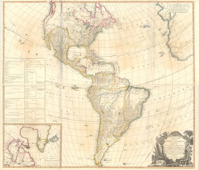
Auction 170, Lot 89
Subject: Western Hemisphere - America
Laurie & Whittle
[On 4 Sheets] A New Map of the Whole Continent of America, Divided into North and South and West Indies. Wherein Are Exactly Described the United States of North America..., 1794
Size: 46.6 x 20.2 inches (118.4 x 51.3 cm)
Estimate: $1,000 - $1,300
Impressive Four-Sheet Map Featuring Two Possible Locations for a River of the West
Sold for: $600
Closed on 11/14/2018
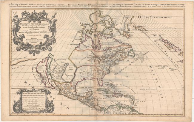
Auction 170, Lot 92
Subject: Colonial North America
Sanson/Mortier
Amerique Septentrionale Divisee en ses Principales Parties, ou sont Distingues les uns des Autres les Estats..., 1696
Size: 34.2 x 21.1 inches (86.9 x 53.6 cm)
Estimate: $1,800 - $2,200
Showing the Island of California
Sold for: $1,100
Closed on 11/14/2018
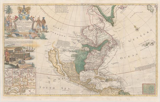
Auction 170, Lot 97
Subject: Colonial North America
Moll, Herman
To the Right Honourable John Lord Sommers Baron of Evesham ... This Map of North America According to ye Newest and Most Exact Observations..., 1755
Size: 38.3 x 23.1 inches (97.3 x 58.7 cm)
Estimate: $5,500 - $7,000
Unrecorded Edition of Moll's Famous "Codfish Map" of North America Updated to Reflect the French & Indian War
Sold for: $4,000
Closed on 11/14/2018
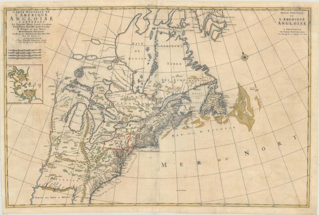
Auction 170, Lot 126
Subject: Colonial Eastern United States & Canada
Mortier, Pierre
Carte Nouvelle de l'Amerique Angloise Contenant la Virginie, Mary-Land, Caroline, Pensylvania Nouvelle Iorck. N: Iarsey N: France, et les Terres Nouvellement Decouerte..., 1700
Size: 35.4 x 23.4 inches (89.9 x 59.4 cm)
Estimate: $1,900 - $2,200
A Map Showing Fascinating Geographic Misconceptions
Unsold
Closed on 11/14/2018
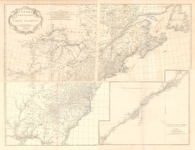
Auction 170, Lot 128
Subject: Colonial Eastern United States & Canada
Anville, Jean Baptiste Bourguignon d'
[On 4 Sheets] Canada Louisiane et Terres Angloises, 1755
Size: 22 x 18.8 inches (55.9 x 47.8 cm)
Estimate: $1,400 - $1,700
D'Anville's Spectacular Map of Eastern Seaboard
Unsold
Closed on 11/14/2018
Auction 170, Lot 131
Subject: Colonial Eastern United States & Canada
Sotzmann, Daniel Friedrich
Die Vereinigten Staaten von Nord-America. Nach der von Wm. Faden 1783 herausgegebenen Charte / Les Etats Unis de l'Amerique Septentrionale d'Apres la Carte de Wm. Faden Publiee a Londres en 1783..., 1785
Size: 10 x 7.6 inches (25.4 x 19.3 cm)
Estimate: $600 - $800
Rare, Multi-Lingual Reduced Version of Faden's Map of 1783
Sold for: $550
Closed on 11/14/2018
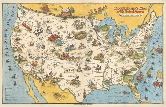
Auction 170, Lot 154
Subject: United States
Bootlegger's Map of the United States, 1931
Size: 33.9 x 21.4 inches (86.1 x 54.4 cm)
Estimate: $1,200 - $1,500
McCandlish's Humorous Prohibition Map in Hand Color
Sold for: $750
Closed on 11/14/2018
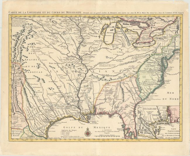
Auction 170, Lot 158
Subject: Colonial Eastern United States, Louisiana Territory
Delisle/Covens & Mortier
Carte de la Louisiane et du Cours du Mississipi Dressee sur un Grand Nombre de Memoires Entr'autres sur ceux de Mr. le Maire, 1730
Size: 23.4 x 17.3 inches (59.4 x 43.9 cm)
Estimate: $2,000 - $2,300
Delisle's Influential Map of the Louisiana Territory
Unsold
Closed on 11/14/2018
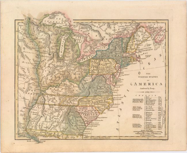
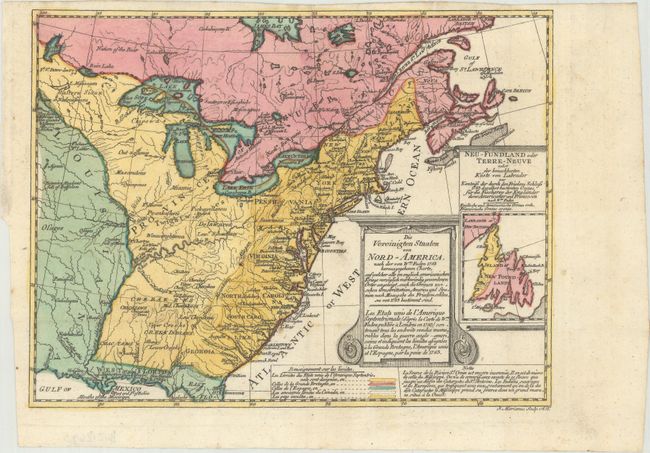
Auction 170, Lot 160
Subject: Eastern United States, Franklin
Wilkinson, Robert
The United States of America Confirmed by Treaty. 1783, 1812
Size: 11.3 x 9.8 inches (28.7 x 24.9 cm)
Estimate: $900 - $1,100
Early Map of the United States Featuring Franklinia and the Indiana Land Company
Sold for: $600
Closed on 11/14/2018
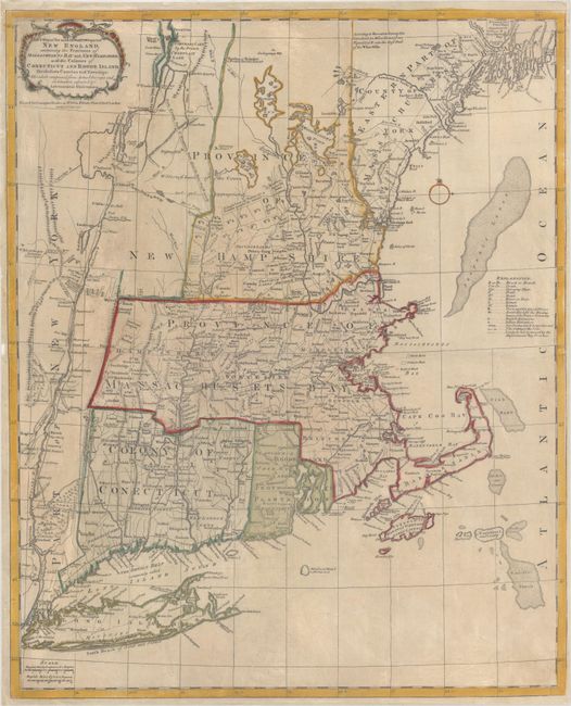
Auction 170, Lot 169
Subject: Colonial New England United States
Bowles, Carrington
A Map of the Most Inhabited Part of New England, Containing the Provinces of Massachusets Bay and New Hampshire, with the Colonies of Conecticut and Rhode Island..., 1771
Size: 20.4 x 25.1 inches (51.8 x 63.8 cm)
Estimate: $3,000 - $4,000
Reduced-Size Edition of Jefferys' Influential Map of New England
Sold for: $1,500
Closed on 11/14/2018
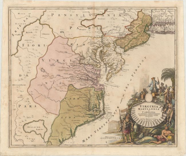
Auction 170, Lot 173
Subject: Colonial Mid-Atlantic United States
Homann, Johann Baptist
Virginia Marylandia et Carolina in America Septentrionali Britannorum Industria Excultae Repraesentatae, 1730
Size: 22.9 x 19.2 inches (58.2 x 48.8 cm)
Estimate: $1,600 - $2,000
Map Created to Promote German Immigration to the New World
Sold for: $1,200
Closed on 11/14/2018
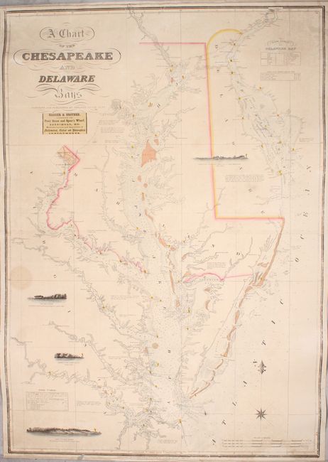
Auction 170, Lot 179
Subject: Mid-Atlantic United States, Chesapeake & Delaware Bays
Lucas, Fielding
A Chart of the Chesapeake and Delaware Bays, 1852
Size: 28.1 x 40.3 inches (71.4 x 102.4 cm)
Estimate: $5,500 - $7,000
Scarce Sea Chart of the Chesapeake and Delaware Bays
Unsold
Closed on 11/14/2018
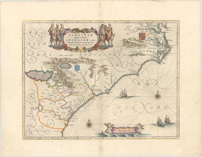
Auction 170, Lot 181
Subject: Colonial Southeast United States
Blaeu, Willem
Virginiae Partis Australis, et Floridae Partis Orientalis, Interjacentiumq Regionum Nova Descriptio, 1642
Size: 19.9 x 15.1 inches (50.5 x 38.4 cm)
Estimate: $1,100 - $1,400
Blaeu's Decorative Map of the Southeast
Sold for: $800
Closed on 11/14/2018
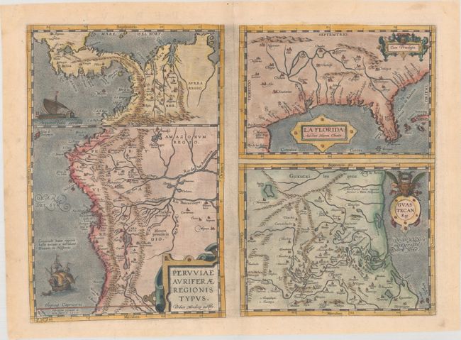
Auction 170, Lot 186
Subject: Southern United States, Central America & Peru
Ortelius, Abraham
Peruviae Auriferae Regionis Typus [on sheet with] La Florida [and] Guastecan Reg., 1584
Size: 18.1 x 13.1 inches (46 x 33.3 cm)
Estimate: $1,100 - $1,400
Features the First Printed Map of the Southern United States
Sold for: $800
Closed on 11/14/2018
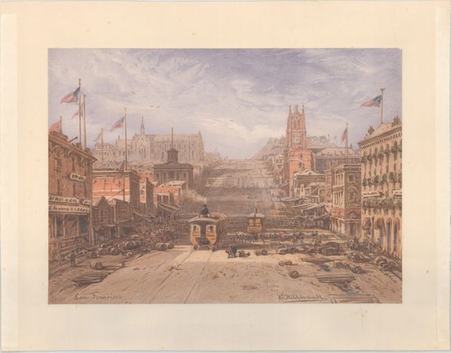
Auction 170, Lot 236
Subject: San Francisco, California
Hildebrandt, E.
San Francisco, 1864
Size: 15 x 10.8 inches (38.1 x 27.4 cm)
Estimate: $1,000 - $1,300
Lovely Chromolithograph of California Street in San Francisco
Sold for: $500
Closed on 11/14/2018
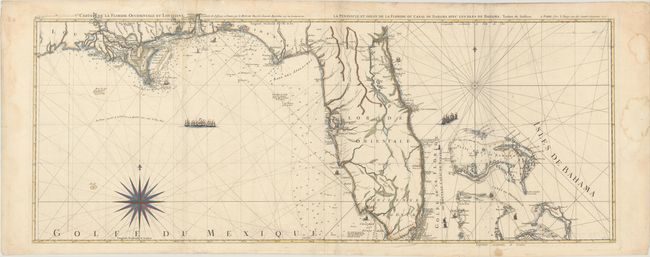
Auction 170, Lot 248
Subject: Florida
Le Rouge, George Louis
Carte de la Floride Occidentale et Louisiane / La Peninsule et Golfe de la Floride ou Canal de Bahama avec les Isles de Bahama, 1777
Size: 47.2 x 18.2 inches (119.9 x 46.2 cm)
Estimate: $1,800 - $2,100
Important Map of Florida and Its Coastlines
Sold for: $1,200
Closed on 11/14/2018
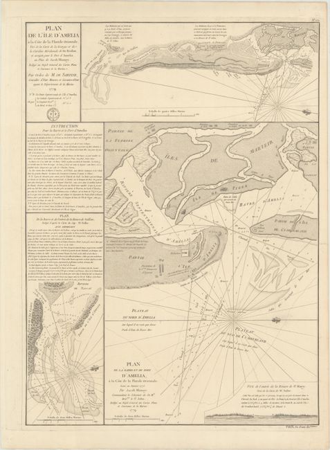
Auction 170, Lot 256
Subject: Amelia Island, Florida
Depot de la Marine
Plan de l'Ile d'Amelia... [on sheet with] Plan de la Barre et du Port d'Amelia... [and] Plan de la Barre et de l'Entree de la Riviere de Nassau..., 1779
Size: 17.1 x 23.3 inches (43.4 x 59.2 cm)
Estimate: $800 - $950
Issued for Use by the French Navy during the American Revolution
Sold for: $550
Closed on 11/14/2018
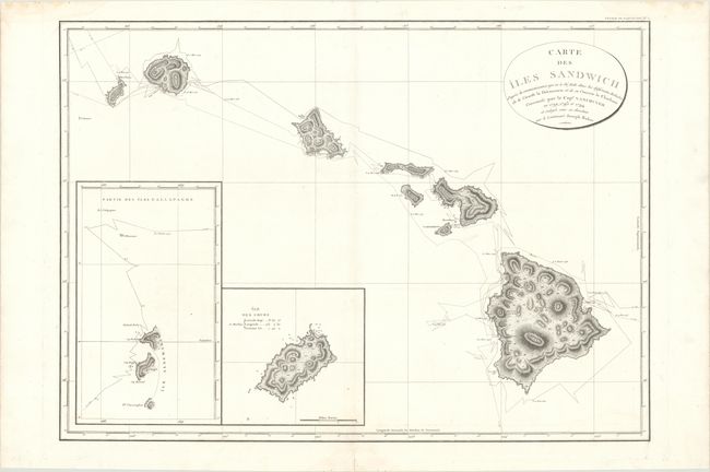
Auction 170, Lot 259
Subject: Hawaii
Vancouver, George (Capt)
Carte des Iles Sandwich d'Apres la Reconnoissance qui en a ete Faite dans les Differentes Relaches de la Corvelle la Decouverte et de sa Conserve le Chatham..., 1799
Size: 30.2 x 21.6 inches (76.7 x 54.9 cm)
Estimate: $1,400 - $1,700
Vancouver's Large Chart of Hawaii
Sold for: $700
Closed on 11/14/2018
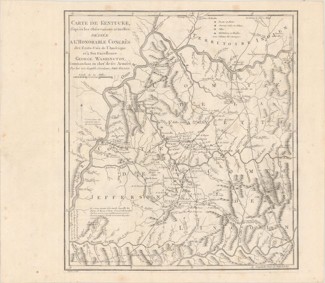
Auction 170, Lot 267
Subject: Kentucky
Filson, John
Carte de Kentucke, d'Apres les Observations Actuelles; Dediee a l'Honorable Congres des Etas-Unis de l'Amerique et a Son Excellence George Washington... [with] [2 Volumes] Lettres d'un Cultivateur Americain..., 1784
Size: 12.4 x 13.7 inches (31.5 x 34.8 cm)
Estimate: $2,400 - $3,000
The First Map of Kentucky
Sold for: $1,200
Closed on 11/14/2018
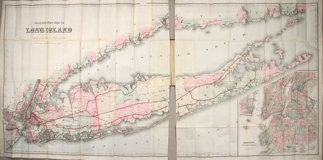
Auction 170, Lot 291
Subject: Long Island, New York
Colton, G.W. & C.B.
Colton's New Map of Long Island, 1886
Size: 64 x 30 inches (162.6 x 76.2 cm)
Estimate: $3,500 - $4,250
Monumental Map of Long Island in Mint Condition
Unsold
Closed on 11/14/2018
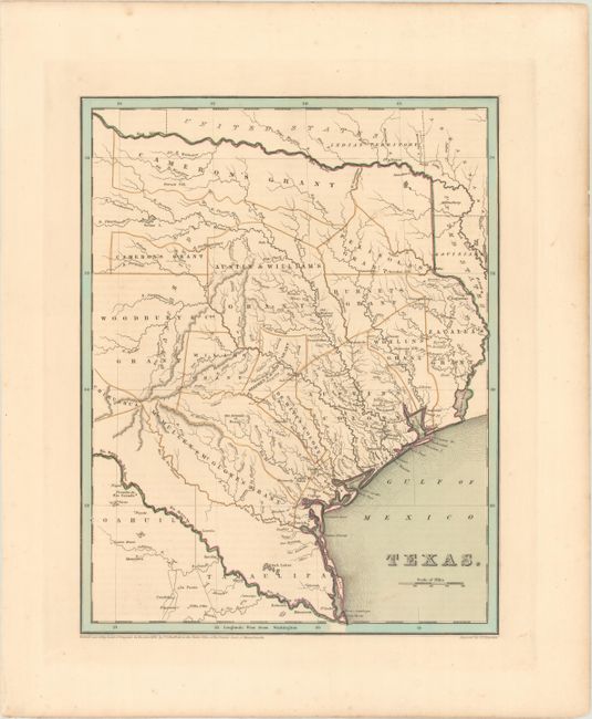
Auction 170, Lot 308
Subject: Texas
Bradford, Thomas Gamaliel
Texas, 1838
Size: 11.2 x 14.3 inches (28.4 x 36.3 cm)
Estimate: $2,000 - $2,400
Bradford's Republic of Texas
Sold for: $3,000
Closed on 11/14/2018
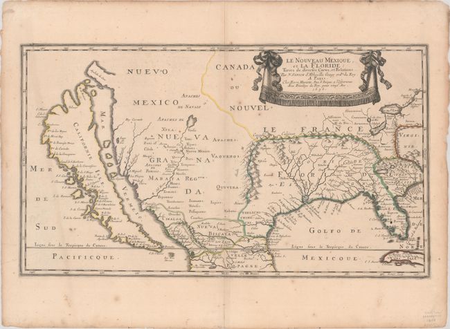
Auction 170, Lot 328
Subject: Colonial United States & Mexico
Sanson/Mariette
Le Nouveau Mexique, et la Floride: Tirees de Diverses Cartes, et Relations, 1656
Size: 21.4 x 12.2 inches (54.4 x 31 cm)
Estimate: $5,500 - $7,000
First Edition of Sanson's Important Map of the American Southwest
Sold for: $4,000
Closed on 11/14/2018
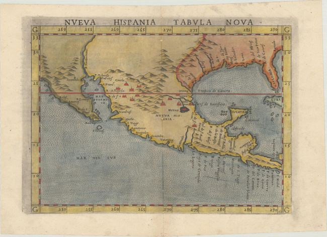
Auction 170, Lot 330
Subject: Southern United States & Mexico
Ruscelli, Girolamo
Nueva Hispania Tabula Nova, 1561
Size: 9.6 x 7 inches (24.4 x 17.8 cm)
Estimate: $1,300 - $1,600
A Foundation Map for the American Southwest
Sold for: $1,100
Closed on 11/14/2018
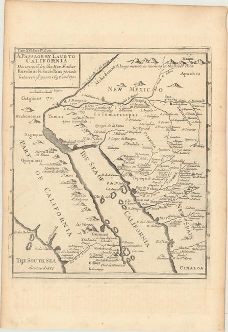
Auction 170, Lot 335
Subject: Southwestern United States & Mexico
Kino, Eusebio Francisco, SJ
A Passage by Land to California Discover'd by the Rev. Father Eusebius Francis Kino Jesuite Between ye Years 1698 and 1701 [with text], 1721
Size: 8 x 9.1 inches (20.3 x 23.1 cm)
Estimate: $1,000 - $1,300
Father Kino's Important Map of California
Unsold
Closed on 11/14/2018
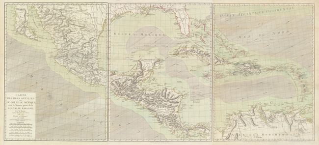
Auction 170, Lot 365
Subject: Gulf of Mexico & Caribbean
Bonne, Rigobert
[On 3 Sheets] Carte des Isles Antilles et du Golfe du Mexique; avec la Majeure Partie de la Nouvelle Espagne, 1786
Size: 19.5 x 25.9 inches (49.5 x 65.8 cm)
Estimate: $1,400 - $1,700
Scarce Large-Format Map in Full Original Color
Sold for: $1,000
Closed on 11/14/2018
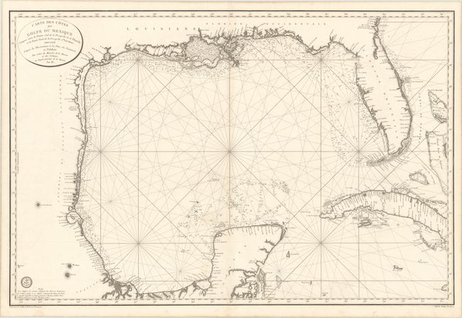
Auction 170, Lot 367
Subject: Gulf of Mexico & Cuba
Depot de la Marine
Carte des Cotes du Golfe du Mexique Compris Entre la Pointe Sud de la Presqu'Ile de la Floride et la Pointe Nord de la Presqu'Ile d'Yucatan…, 1800
Size: 35.9 x 23.8 inches (91.2 x 60.5 cm)
Estimate: $1,200 - $1,500
Important Map for the Texas Collector
Sold for: $1,300
Closed on 11/14/2018
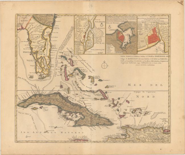
Auction 170, Lot 374
Subject: Florida, Cuba & Bahamas
Ottens, Reiner and Joshua
Nova Tabula Exhibens Insulas Cubam et Hispaniolam Vulgo S. Domingo Dictam Insulas Lucaias seu Bahamanas ac Peninsulam Floridae..., 1740
Size: 21.3 x 17.6 inches (54.1 x 44.7 cm)
Estimate: $2,000 - $2,400
Important map of the Florida Peninsula from the War of Jenkin's Ear
Sold for: $1,100
Closed on 11/14/2018
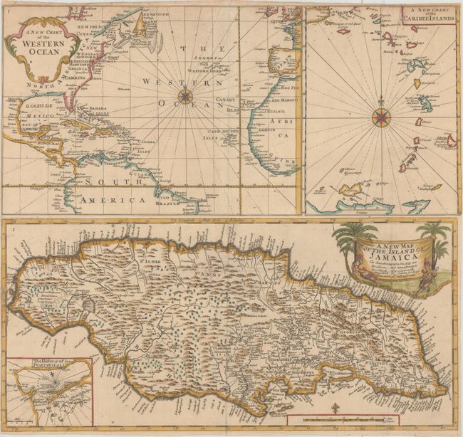
Auction 170, Lot 379
Subject: Jamaica, Caribbean
A New Map of the Island of Jamaica [on sheet with] A New Chart of the Western Ocean [and] A New Chart of the Caribee Islands , 1707
Size: 21.5 x 19.8 inches (54.6 x 50.3 cm)
Estimate: $800 - $1,000
Very Rare Map from Sir Hans Sloane's Account of Jamaica
Sold for: $1,000
Closed on 11/14/2018
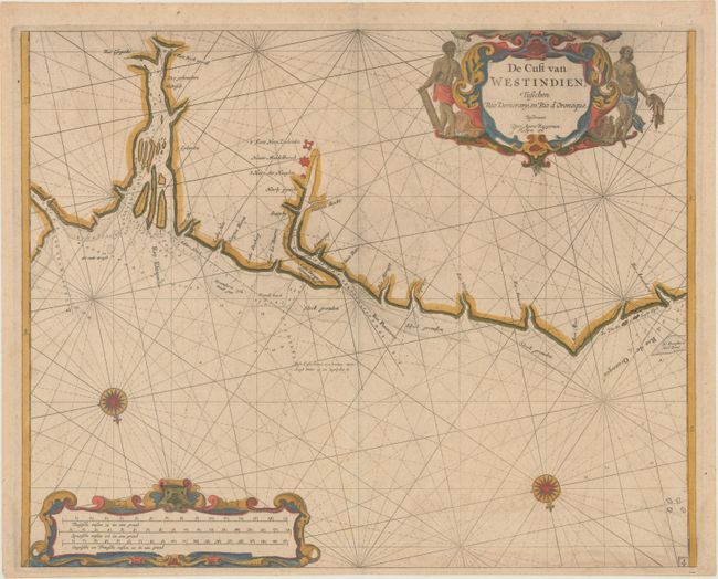
Auction 170, Lot 417
Subject: Guyana
Roggeveen, Arent
De Cust van Westindien, Tusschen Rio Demerary, en Rio d'Oronoque, 1685
Size: 20.1 x 16.1 inches (51.1 x 40.9 cm)
Estimate: $800 - $1,000
Extremely Rare Chart of Guyana by Roggeveen
Sold for: $475
Closed on 11/14/2018
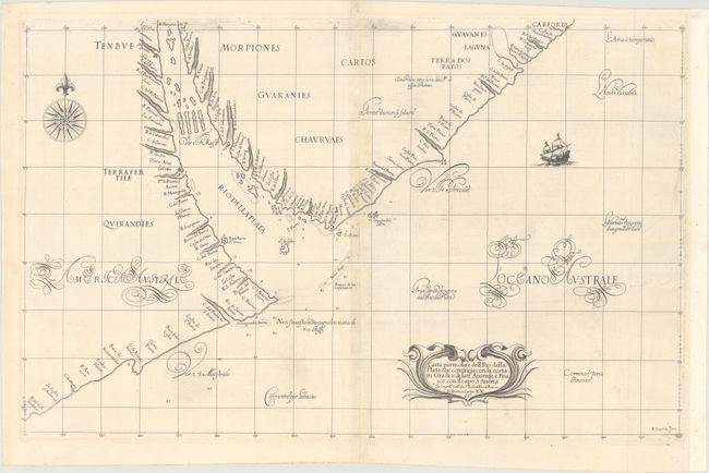
Auction 170, Lot 427
Subject: Argentina & Uruguay
Dudley, Robert (Sir)
Carta Particolare dell' Rio della Plata che Comincia con la Costa..., 1661
Size: 29.1 x 18.5 inches (73.9 x 47 cm)
Estimate: $1,400 - $1,700
Dudley's Rare Chart of the Rio de la Plata
Sold for: $850
Closed on 11/14/2018
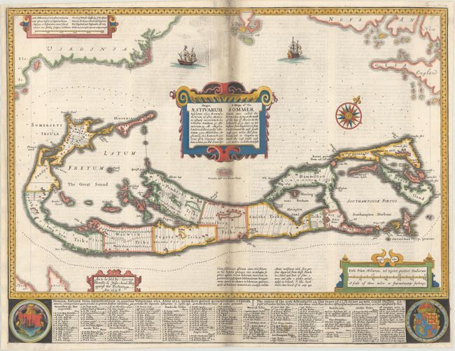
Auction 170, Lot 432
Subject: Bermuda
Speed, John
Mappa Aestivarum Insularum Alias Bermudas Dictarum... / A Mapp of the Sommer Islands Once Called the Bermudas..., 1626
Size: 20.6 x 15.8 inches (52.3 x 40.1 cm)
Estimate: $1,500 - $1,800
Speed's Foundation Map of Bermuda
Sold for: $800
Closed on 11/14/2018
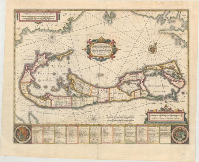
Auction 170, Lot 433
Subject: Bermuda
Hondius/Jansson
Mappa Aestivarum Insularum, Alias Barmudas Dictarum, ad Ostia Mexicani Aestuary Jacetium..., 1638
Size: 20.3 x 15.5 inches (51.6 x 39.4 cm)
Estimate: $1,500 - $1,800
Map of Bermuda Based on Richard Norwood's Famous Survey
Sold for: $500
Closed on 11/14/2018
74 lots
Page 1 of 2