Subject: Colonial New England United States
Period: 1771 (dated)
Publication:
Color: Hand Color
Size:
20.4 x 25.1 inches
51.8 x 63.8 cm
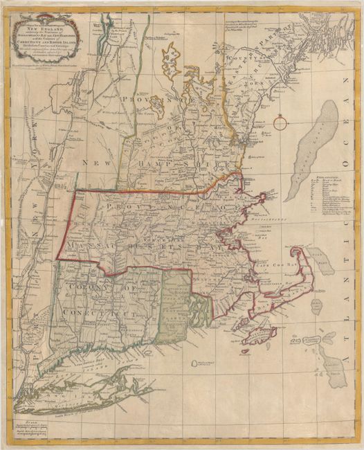
This is the second state of Bowles' one-sheet issue of Jefferys' influential 4-sheet map of New England. The map closely follows the second edition of Jefferys' map (1759), although the two insets of Fort Frederik and Boston Harbor are eliminated. Jefferys' map was first published in 1755 at the beginning of the French and Indian War, and became the most influential map of the region for the next several decades. The map was compiled by Bradock Mead (alias John Green) from influential contemporary sources. Bowles' reduced-size edition shows villages, towns, forts, roads, counties, watershed, mountains and topography, and information along the coast, including islands and bays. A fascinating map that presented up-to-date information on the region. In northern New Hampshire is a "double line of towns for a frontier against the Indians" with "wilderness lands of the Crown not yet appropriated" to the north, and a "French encroachment" even further north. Bowles' one-sheet issue is actually much rarer than Jefferys' 4-sheet map, and this is the first example that has been listed with OWA.
References: McCorkle #771.4; Sellers & Van Ee #810; Stevens & Tree (MCC-39) #32(b).
Condition: B+
A dark impression on paper with a fleur-de-lis coat of arms watermark, some printer's ink residue, light soiling, and narrow margins. There are professional repairs to a few small chips and tears in the blank margins.