Subject: Western Hemisphere - America
Period: 1606 (published)
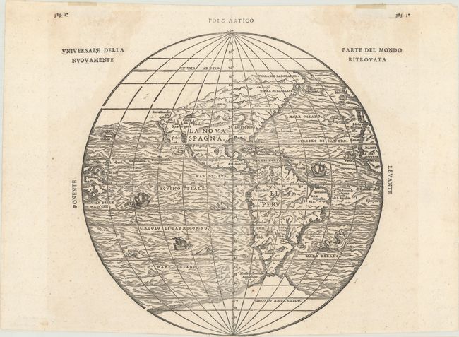
Publication: Navigationi et Viaggi, Vol. III
Color: Black & White
Size:
10.5 x 10.6 inches
26.7 x 26.9 cm
This extremely important map of the Americas includes the first mention of several names from the explorations of Coronado of 1540-42, including the elusive cities of Cibola and Quivera. The Sierra Nevadas appear for the first time, following the voyage of Juan Rodrequez Cabrillo in 1542. The map was originated by Gastaldi and is one of four he did for Ramusio. It leaves open the question of a land bridge from North America to Asia. This is the second issue from the second block, published in 1606. The first block, with identical geography, was destroyed in a fire at the printing establishment of Thomaso Guinti shortly after its publication in 1556. A nice example of this important and scarce map.
References: Burden #34; Wagner (NW) #35; Wheat (TMW) #9; Sabin #67742.
Condition: B+
A dark, crisp impression with a few tiny fold separations and one minor tear along the bottom centerfold that have all been professionally repaired on verso. The sheet has been trimmed at bottom with the words "Polo Antartico" missing (likely by the bookbinder). There are faint dampstains outside of the image at upper left and right, hinge tape along the top edge of the sheet, and a printer's crease to the left of the centerfold.