Subject: Gulf of Mexico & Cuba
Period: 1800 (dated)
Publication:
Color: Black & White
Size:
35.9 x 23.8 inches
91.2 x 60.5 cm
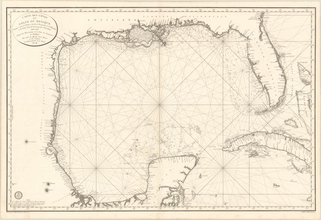
This is one of the earliest charts to name the bays of Galveston and Bernardo (now Matagorda) in Texas. This first French edition was published just one year after the map on which it was based and is nearly identical: Carta Esferica que Comprehende las Costas del Seno Mexicano by Depósito Hidrográfico de Marina of Spain, which was the prototype for maps of the Gulf for many years. Carta Esferica was the first chart of the Texas coast based on actual soundings and exploration, and outlined the coastline and the lower course of its rivers. The exploration was conducted by Jose Antonio de Evia in 1785-86, who named Galveston Bay after his patron, Bernardo de Galvez, the interim governor of Spanish Louisiana.
The chart extends from Florida to the Yucatan peninsula, and includes parts of Cuba and the Bahamas. A note at bottom left explains that the soundings are given in French fathoms, and includes a lettered guide to the composition of the Gulf floor as indicated on the map. Engraved by E. Collin with lettering by Besancon. The seal of the Depot de la Marine is at bottom left and Prix Deux Francs appears below neatline at right.
References: Phillips (Atlases) #590-67a; Streeter (Texas) #1030; cf. Martin & Martin, p. 105.
Condition: A
A nice impression on sturdy, watermarked paper with a hint of toning along the centerfold and the edges of the sheet.