Showing Featured Lots(remove filter)
Showing results for:Auction 169
Catalog Archive
63 lots
Page 1 of 2
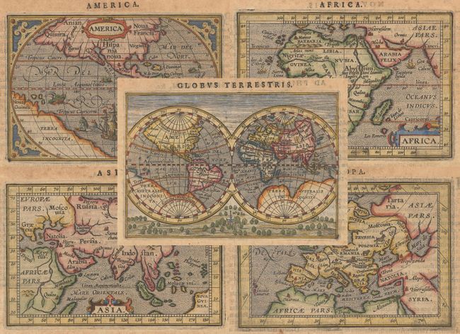
Auction 169, Lot 13
Subject: World & Continents
Ortelius/Coignet
[Lot of 5] Globus Terrestris [and] America [and] Africa [and] Asia [and] Europa, 1609
Size: 4.9 x 3.3 inches (12.4 x 8.4 cm)
Estimate: $1,800 - $2,200
Matching Set from Miniature Ortelius Atlas
Sold for: $1,200
Closed on 9/12/2018
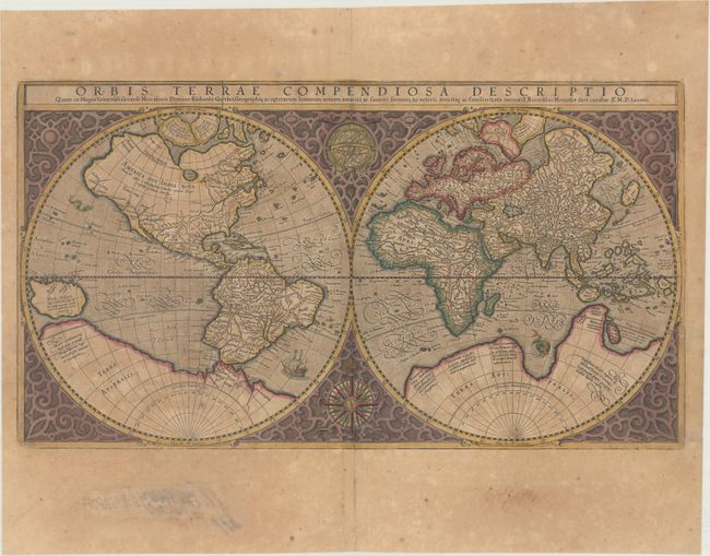
Auction 169, Lot 16
Subject: World
Mercator, Rumold
Orbis Terrae Compendiosa Descriptio quam ex Magna Universali Gerardi Mercatoris..., 1587
Size: 20.5 x 11.3 inches (52.1 x 28.7 cm)
Estimate: $3,750 - $4,500
Mercator's Double-Hemisphere World Map in Full Contemporary Color
Sold for: $2,750
Closed on 9/12/2018
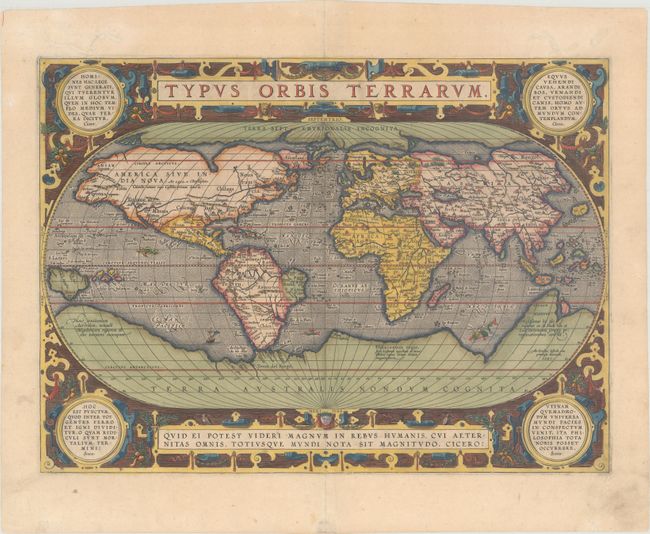
Auction 169, Lot 17
Subject: World
Ortelius, Abraham
Typus Orbis Terrarum, 1587
Size: 19.1 x 13.9 inches (48.5 x 35.3 cm)
Estimate: $6,000 - $7,500
Ortelius' Third World Map in an Oval Projection
Sold for: $4,500
Closed on 9/12/2018
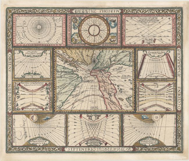
Auction 169, Lot 19
Subject: World
Ritter, Franz
[Untitled - World and Horological Diagrams], 1607
Size: 13.6 x 11.2 inches (34.5 x 28.4 cm)
Estimate: $3,250 - $4,250
Ritter's Unusual Sun-Dial World Map - First State
Sold for: $2,400
Closed on 9/12/2018
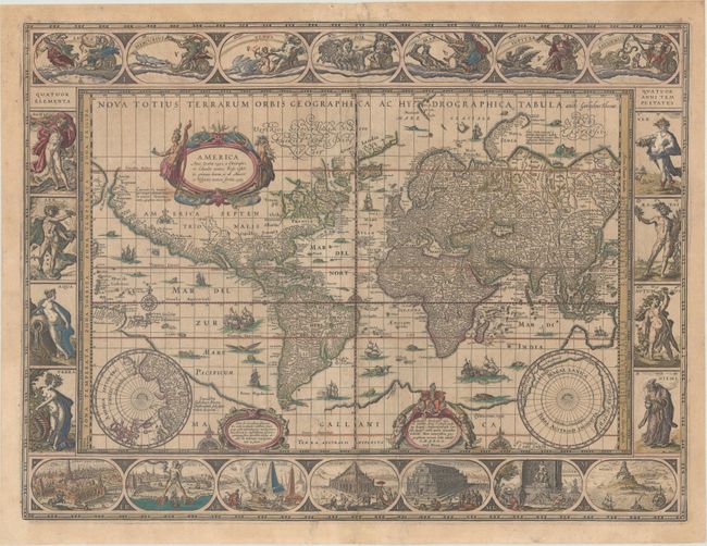
Auction 169, Lot 21
Subject: World
Blaeu, Willem
Nova Totius Terrarum Orbis Geographica ac Hydrographica Tabula, 1635
Size: 21.4 x 16.1 inches (54.4 x 40.9 cm)
Estimate: $9,500 - $11,000
Blaeu's Magnificent Carte-a-Figures World Map in Full Contemporary Color
Unsold
Closed on 9/12/2018
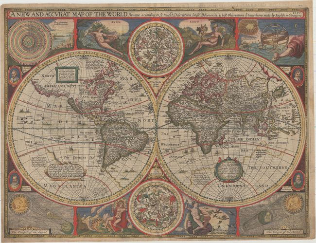
Auction 169, Lot 22
Subject: World
Speed, John
A New and Accurat Map of the World Drawne According to ye Truest Descriptions Latest Discoveries & Best Observations yt Have Beene Made by English or Strangers, 1651
Size: 20.6 x 15.6 inches (52.3 x 39.6 cm)
Estimate: $14,000 - $16,000
Speed's Double-Hemisphere World Map
Unsold
Closed on 9/12/2018
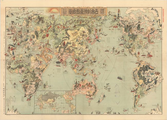
Auction 169, Lot 42
Subject: World
[Japanese Manga World Map - New Cartoon View of the World], 1924
Size: 40.8 x 28.1 inches (103.6 x 71.4 cm)
Estimate: $2,750 - $3,500
Fascinating Japanese Satirical Map Published After WWI
Sold for: $2,200
Closed on 9/12/2018
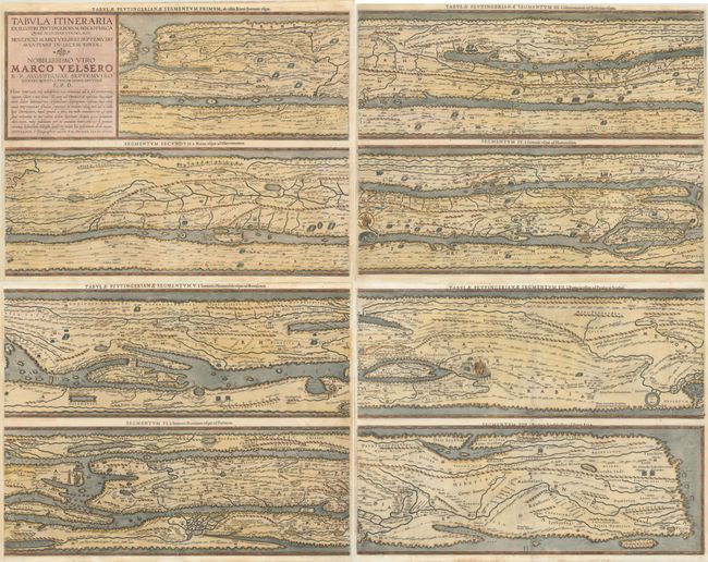
Auction 169, Lot 47
Subject: Ancient World
Ortelius, Abraham
[On 4 Sheets] Tabula Itineraria ex Illustri Peutingerorum Bibliotheca quae Augustae Vindel..., 1598
Size: 20.3 x 15.6 inches (51.6 x 39.6 cm)
Estimate: $5,000 - $6,000
Ortelius' Scarce Peutinger Table
Sold for: $3,500
Closed on 9/12/2018
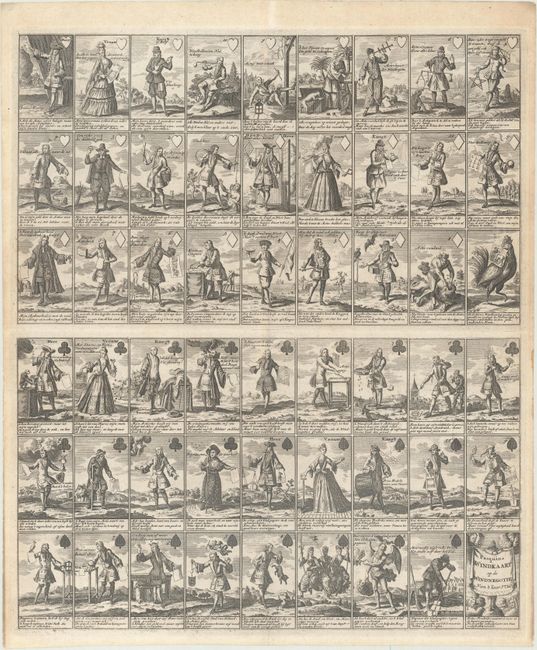
Auction 169, Lot 62
Subject: Cartographic Miscellany, Playing Cards
Anon.
Pasquins Windkaart. Op de Windnegotie van 't Iaar 1720, 1720
Size: 17.3 x 20.4 inches (43.9 x 51.8 cm)
Estimate: $1,600 - $1,900
Sheet of Playing Cards Satirizing the Mississippi Bubble
Unsold
Closed on 9/12/2018
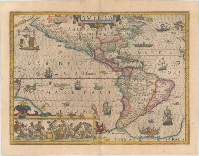
Auction 169, Lot 67
Subject: Western Hemisphere - America
Hondius, Jodocus
America, 1623
Size: 19.9 x 14.8 inches (50.5 x 37.6 cm)
Estimate: $3,500 - $4,250
Hondius' Important Map of the Americas in Full Contemporary Color
Sold for: $3,750
Closed on 9/12/2018
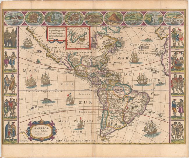
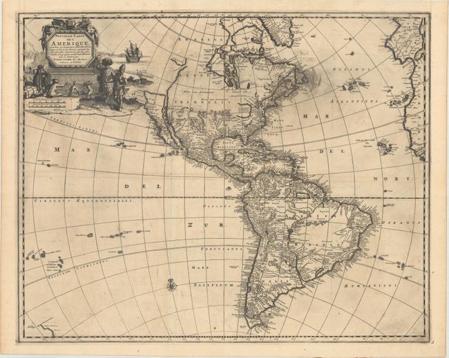
Auction 169, Lot 69
Subject: Western Hemisphere - America
Blaeu, Willem
Americae Nova Tabula, 1640
Size: 21.9 x 16.3 inches (55.6 x 41.4 cm)
Estimate: $5,000 - $6,500
Blaeu's Stunning Carte-a-Figures Map of the Americas in Full Contemporary Color
Unsold
Closed on 9/12/2018
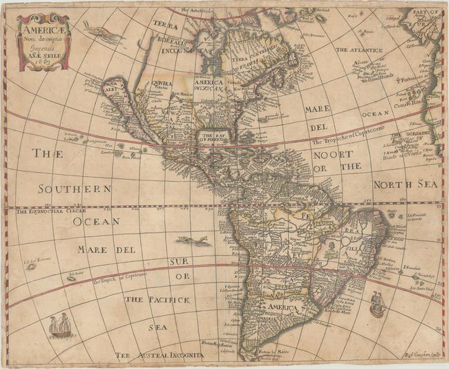
Auction 169, Lot 70
Subject: Western Hemisphere - America
Seile, Anae
Americae Nova Descriptio , 1663
Size: 16.3 x 13.1 inches (41.4 x 33.3 cm)
Estimate: $800 - $950
One of the Rare Antique Maps Published Exclusively by a Woman
Sold for: $600
Closed on 9/12/2018
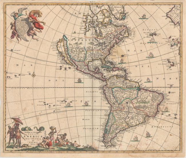
Auction 169, Lot 72
Subject: Western Hemisphere - America
Wit, Frederick de
Novissima et Accuratissima Totius Americae Descriptio, 1678
Size: 22.8 x 19.3 inches (57.9 x 49 cm)
Estimate: $1,300 - $1,600
De Wit's Derivative of Visscher's Classic Map of the Americas with the Island of California
Sold for: $850
Closed on 9/12/2018
Auction 169, Lot 78
Subject: Western Hemisphere - America
Aa, Pieter van der
Nouvelle Carte de l'Amerique, avec Tous ses Royaumes, Etats, Iles, Ports, Bayes et Rivieres, Dressee Suivant les Plus Nouvelles Decouvertes par les Habiles Geographes..., 1720
Size: 21.1 x 17 inches (53.6 x 43.2 cm)
Estimate: $1,500 - $1,800
Scarce Map with Interesting Geographical Myths
Sold for: $1,100
Closed on 9/12/2018
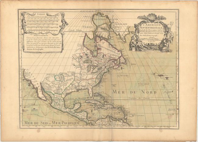
Auction 169, Lot 89
Subject: Colonial North America
Sanson/Mariette
Amerique Septentrionale par N. Sanson..., 1669
Size: 21.9 x 15.5 inches (55.6 x 39.4 cm)
Estimate: $2,200 - $2,500
Important Map for Great Lakes Collectors
Sold for: $1,400
Closed on 9/12/2018
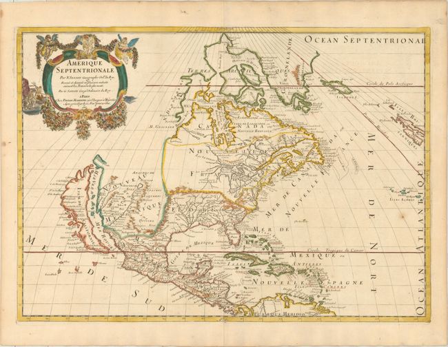
Auction 169, Lot 91
Subject: Colonial North America
Delisle, Guillaume
L'Amerique Septentrionale. Dressee sur les Observations de Mrs. de l'Academie Royale des Sciences..., 1700
Size: 23.8 x 17.9 inches (60.5 x 45.5 cm)
Estimate: $1,900 - $2,200
Delisle's Foundation Map of North America
Unsold
Closed on 9/12/2018
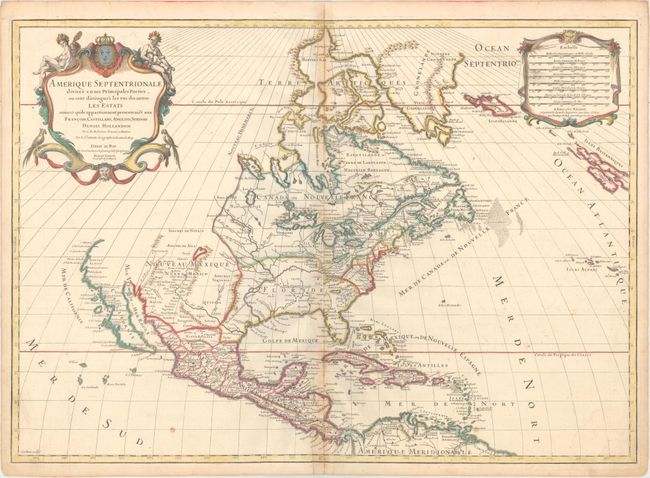
Auction 169, Lot 94
Subject: Colonial North America
Sanson/Jaillot
Amerique Septentrionale Divisee en ses Principales Parties, ou sont Distingues les uns des Autres les Estats..., 1719
Size: 25.3 x 18 inches (64.3 x 45.7 cm)
Estimate: $1,400 - $1,700
Sanson/Jaillot's Map of North America
Sold for: $800
Closed on 9/12/2018
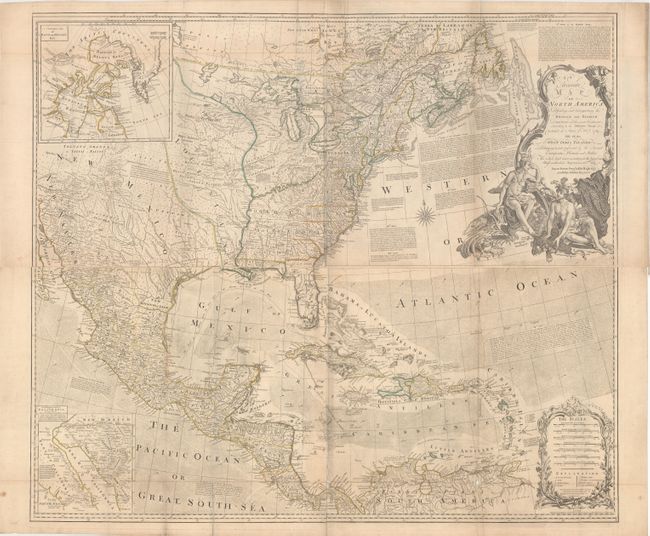
Auction 169, Lot 98
Subject: Colonial North America
Bowen & Gibson
[On 2 Sheets] An Accurate Map of North America. Describing and Distinguishing the British and Spanish Dominions on This Great Continent; According to the Definitive Treaty Concluded at Paris 10th Feby. 1763..., 1775
Size: 45.8 x 19.8 inches (116.3 x 50.3 cm)
Estimate: $3,250 - $4,000
Bowen & Gibson's Large Map of North America Issued Just Prior to the American Revolution
Unsold
Closed on 9/12/2018
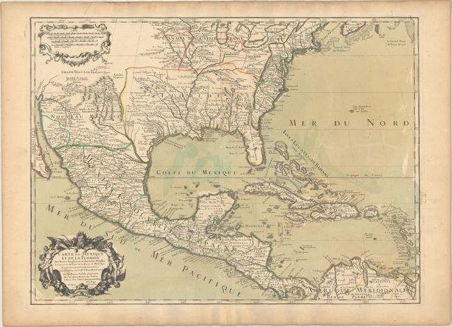
Auction 169, Lot 111
Subject: Colonial Eastern North America & West Indies
Delisle, Guillaume
Carte du Mexique et de la Floride des Terres Angloises et des Isles Antilles du Cours et des Environs de la Riviere de Mississipi..., 1703
Size: 25.5 x 18.6 inches (64.8 x 47.2 cm)
Estimate: $2,750 - $3,500
Landmark in American Cartography - First Printed Map to Accurately Depict the Mouth of the Mississippi River
Sold for: $2,000
Closed on 9/12/2018
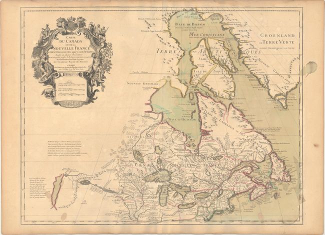
Auction 169, Lot 130
Subject: Colonial Northeastern United States & Canada, Great Lakes
Delisle, Guillaume
Carte du Canada ou de la Nouvelle France et des Decouvertes qui y ont ete Faites..., 1703
Size: 25.6 x 19.6 inches (65 x 49.8 cm)
Estimate: $2,200 - $2,500
Delisle's Seminal Map of Canada and the Great Lakes
Sold for: $1,600
Closed on 9/12/2018
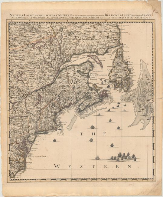
Auction 169, Lot 133
Subject: Colonial Northeastern United States & Canada
Popple/Covens & Mortier
Nouvelle Carte Particuliere de l'Amerique ou sont Exactement Marquees la Nouvelle Bretagne, le Canada ou Nouvelle France, la Nouvelle Ecosse, la Nouvelle Angleterre, la Nouvelle York..., 1741
Size: 20.5 x 22.4 inches (52.1 x 56.9 cm)
Estimate: $2,400 - $3,000
The Northeastern Sheet of the Reduced-Size Edition of Popple's Map
Unsold
Closed on 9/12/2018
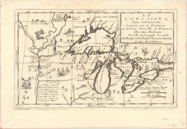
Auction 169, Lot 145
Subject: Colonial Central United States & Canada, Great Lakes
Coronelli, Vincenzo Maria
La Louisiana, Parte Settentrionalle, Scoperta Sotto la Protettione di Luigi XIV, Re di Francia, Etc., 1695
Size: 16.6 x 10.1 inches (42.2 x 25.7 cm)
Estimate: $3,500 - $4,250
Coronelli's Important Map of the Great Lakes & Upper Mississippi River Valley
Sold for: $4,000
Closed on 9/12/2018
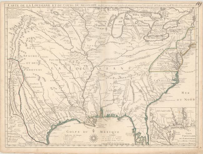
Auction 169, Lot 159
Subject: Colonial Eastern United States
Delisle, Guillaume
Carte de la Louisiane et du Cours du Mississipi Dressee sur un Grand Nombre de Memoires Entrautres sur ceux de Mr. le Maire, 1718
Size: 25.3 x 19.1 inches (64.3 x 48.5 cm)
Estimate: $6,000 - $7,500
A Foundation Map for the Mississippi Valley and the First Appearance of Texas on a Printed Map
Sold for: $4,000
Closed on 9/12/2018
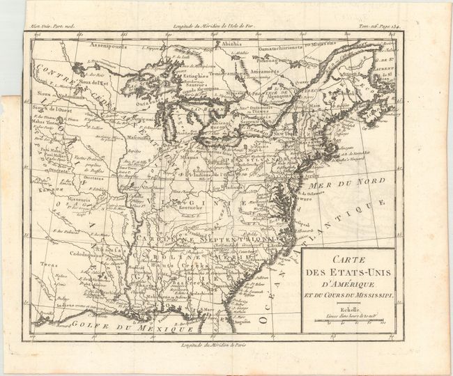
Auction 169, Lot 162
Subject: Eastern United States, Franklin
Brion de la Tour, Louis
Carte des Etats-Unis d'Amerique et du Cours du Mississipi, 1788
Size: 10.6 x 8.7 inches (26.9 x 22.1 cm)
Estimate: $900 - $1,100
One of the Earliest Maps to Feature the State of Franklin
Unsold
Closed on 9/12/2018
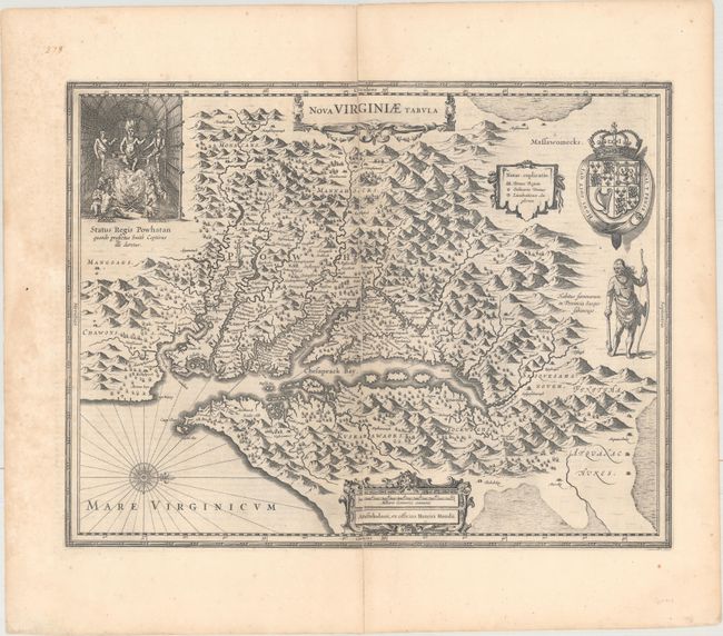
Auction 169, Lot 177
Subject: Colonial Mid-Atlantic United States
Hondius, Henricus
Nova Virginiae Tabula, 1652
Size: 19.4 x 15 inches (49.3 x 38.1 cm)
Estimate: $1,600 - $1,900
One of the Most Important 17th Century Maps of the Chesapeake Bay
Sold for: $1,200
Closed on 9/12/2018
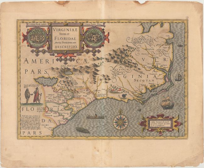
Auction 169, Lot 188
Subject: Colonial Southeast United States
Hondius, Jodocus
Virginiae Item et Floridae Americae Provinciarum, Nova Descriptio, 1628
Size: 19.2 x 13.6 inches (48.8 x 34.5 cm)
Estimate: $1,800 - $2,100
A Seminal Map of the Southeast and Early American Cartography
Sold for: $900
Closed on 9/12/2018
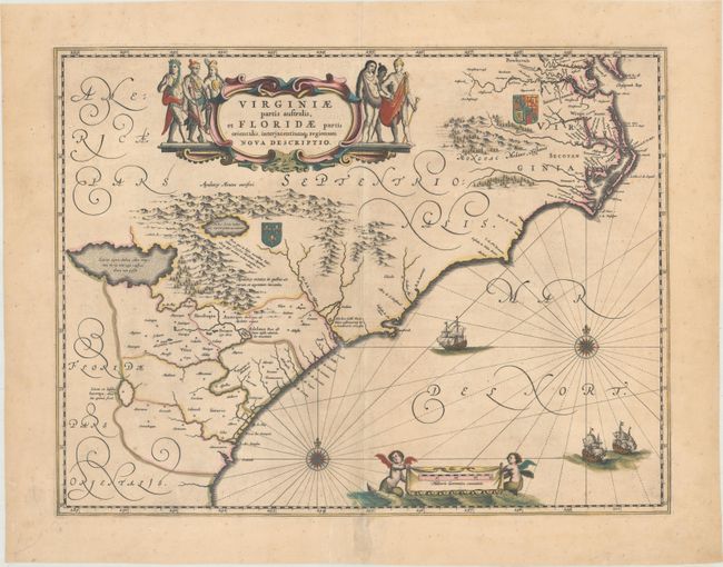
Auction 169, Lot 189
Subject: Colonial Southeast United States
Blaeu, Willem
Virginiae Partis Australis, et Floridae Partis Orientalis, Interjacentiumq Regionum Nova Descriptio, 1680
Size: 19.8 x 15.1 inches (50.3 x 38.4 cm)
Estimate: $1,100 - $1,400
Blaeu's Decorative Map of the Southeast
Sold for: $800
Closed on 9/12/2018
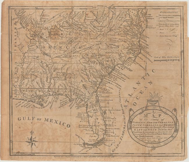
Auction 169, Lot 198
Subject: Southern United States, Franklin
Morse, Jedidiah (Rev.)
[Lot of 2] A Map of the States of Virginia, North Carolina, South Carolina and Georgia; Comprehending the Spanish Provinces of East and West Florida... [with] The American Geography..., 1789
Size: 14.4 x 12.3 inches (36.6 x 31.2 cm)
Estimate: $700 - $850
Rare First State of Purcell's Map Locating the Proposed State of Franklin
Sold for: $600
Closed on 9/12/2018
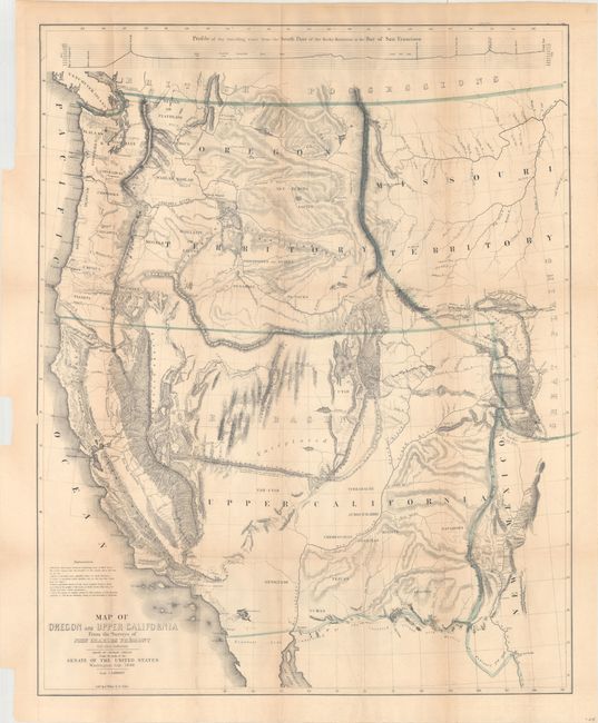
Auction 169, Lot 216
Subject: Western United States
Fremont/Preuss
Map of Oregon and Upper California from the Surveys of John Charles Fremont and Other Authorities, 1848
Size: 26.8 x 33.3 inches (68.1 x 84.6 cm)
Estimate: $1,500 - $1,800
Fremont's Map of the American West
Sold for: $1,100
Closed on 9/12/2018
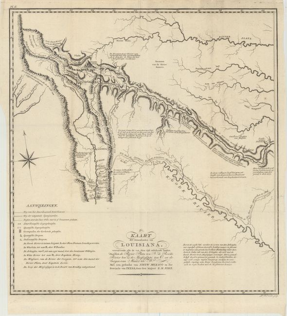
Auction 169, Lot 220
Subject: Southwestern United States
Pike, Zebulon
Kaart der Binnenlanden van Louisiana, Vervattende alle de tot dien tijd Onbekende Landen..., 1812
Size: 14.7 x 15.6 inches (37.3 x 39.6 cm)
Estimate: $2,500 - $3,250
A Cornerstone Map of Early Western Exploration
Unsold
Closed on 9/12/2018
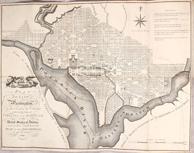
Auction 169, Lot 235
Subject: Washington, D.C.
Russell, John C.
Plan of the City of Washington in the Territory of Columbia... [bound in] An Historical Geographical, Commercial, and Philosophical View of the American United States, and of the European Settlements in America and the West-Indies... Vol. III, 1795
Size: 5.3 x 8.5 inches (13.5 x 21.6 cm)
Estimate: $2,750 - $3,500
Uncommon, Early Large-Format Map of Washington D.C.
Unsold
Closed on 9/12/2018
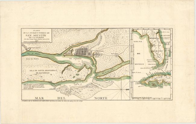
Auction 169, Lot 244
Subject: St. Augustine, Florida
Lopez de Vargas Machuca, Thomas (don)
Plano de la Ciudad y Puerto de San Agustin de la Florida, 1783
Size: 15.3 x 7.4 inches (38.9 x 18.8 cm)
Estimate: $700 - $1,000
Map Showing First Legally Sanctioned Free Black Community in US
Sold for: $500
Closed on 9/12/2018
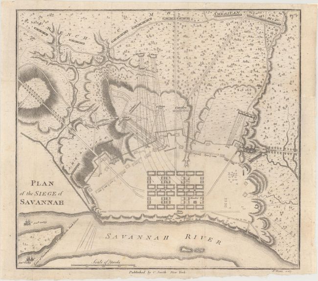
Auction 169, Lot 245
Subject: Savannah, Georgia, Revolutionary War
Smith, Charles
Plan of the Siege of Savannah, 1796
Size: 9.1 x 8.4 inches (23.1 x 21.3 cm)
Estimate: $1,400 - $1,700
Rare Revolutionary War Plan Showing the Siege of Savannah
Sold for: $1,600
Closed on 9/12/2018
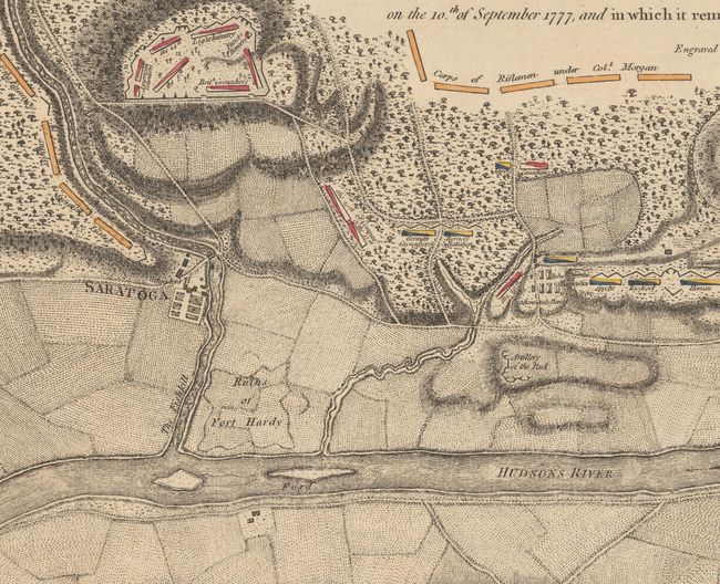
Auction 169, Lot 276
Subject: Colonial Saratoga, New York, Revolutionary War
Faden, William
Plan of the Position Which the Army Under Lt. Genl. Burgoine Took at Saratoga on the 10th of September 1777, and In Which It Remained Till the Convention Was Signed, 1780
Size: 18.7 x 8.6 inches (47.5 x 21.8 cm)
Estimate: $1,200 - $1,500
Important Revolutionary War Map of the 2nd Battle of Saratoga
Sold for: $700
Closed on 9/12/2018
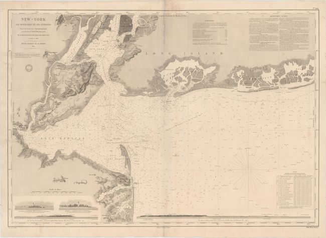
Auction 169, Lot 279
Subject: New York Bay & Bight
Depot de la Marine
New-York ses Mouillages et ses Atterages..., 1854
Size: 34.8 x 24.3 inches (88.4 x 61.7 cm)
Estimate: $1,400 - $1,700
Rare Large Chart of New York Bay and Bight
Sold for: $700
Closed on 9/12/2018
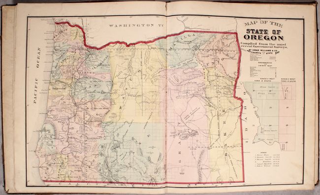
Auction 169, Lot 286
Subject: Oregon
Historical Atlas Map of Marion & Linn Counties Oregon..., 1878
Size: 14.5 x 17.6 inches (36.8 x 44.7 cm)
Estimate: $2,000 - $2,500
The First County Atlas for Oregon
Unsold
Closed on 9/12/2018
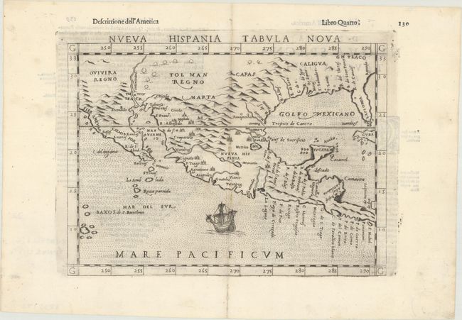
Auction 169, Lot 310
Subject: Southern United States & Mexico
Ruscelli, Girolamo
Nueva Hispania Tabula Nova, 1598
Size: 9.6 x 7.1 inches (24.4 x 18 cm)
Estimate: $1,200 - $1,500
A Foundation Map for the American Southwest
Sold for: $900
Closed on 9/12/2018
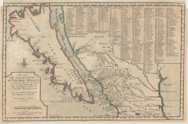
Auction 169, Lot 314
Subject: Southwestern United States & Mexico, California
Fer, Nicolas de
Cette Carte de Californie et du Nouveau Mexique, est Tiree de Celle qui a ete Envoyee par un Grand d'Espagne..., 1700
Size: 13.3 x 8.7 inches (33.8 x 22.1 cm)
Estimate: $950 - $1,200
De Fer's Important Map of the Island of California
Sold for: $650
Closed on 9/12/2018
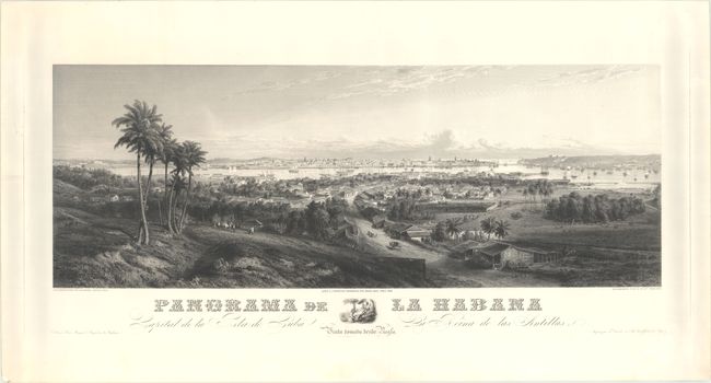
Auction 169, Lot 354
Subject: Havana, Cuba
Willmann, Edward
Panorama de la Habana Capital de la Isla de Cuba la Reina de las Antillas..., 1855
Size: 41.2 x 15.1 inches (104.6 x 38.4 cm)
Estimate: $2,400 - $3,000
Rare Panoramic View of Havana
Sold for: $1,800
Closed on 9/12/2018
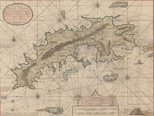
Auction 169, Lot 365
Subject: St. Thomas, US Virgin Islands
Keulen, Gerard van
Nieuwe en Aldereerste Afteekening van 't Eyland St. Thomas. Met alle Desselfs Havenen, Anker Plaatse..., 1719
Size: 39.3 x 23.4 inches (99.8 x 59.4 cm)
Estimate: $3,750 - $4,750
One of the Earliest Maps of St. Thomas
Sold for: $2,100
Closed on 9/12/2018
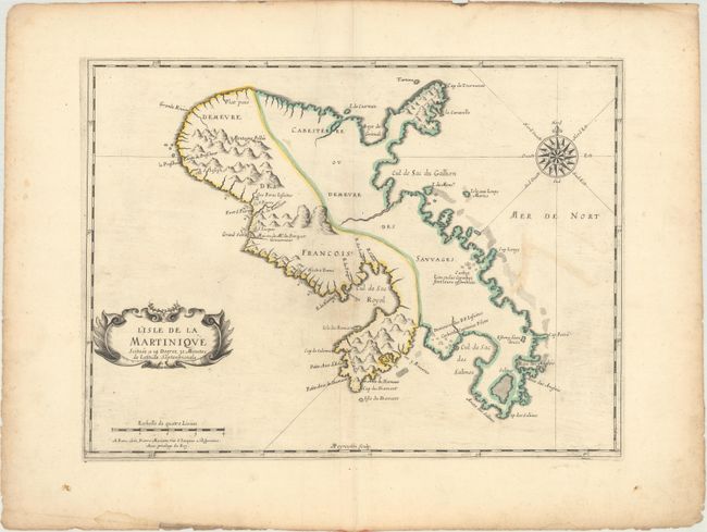
Auction 169, Lot 372
Subject: Martinique
Sanson/Mariette
L'Isle de la Martinique Scituee a 14 Degrez 30 Minutes de Latitude Septentrionale, 1650
Size: 17.1 x 12.6 inches (43.4 x 32 cm)
Estimate: $300 - $400
First Printed Folio Map of Martinique
Sold for: $150
Closed on 9/12/2018
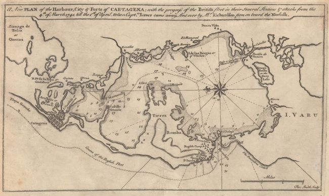
Auction 169, Lot 383
Subject: Cartagena, Colombia
A New Plan of the Harbour, City & Forts of Cartagena; with the Progress of the Britain Fleet in Their Several Stations & Attacks from the 4th of March 1741..., 1741
Size: 11.1 x 6.4 inches (28.2 x 16.3 cm)
Estimate: $1,000 - $1,400
Rare Broadside with First Known Published Engraving of Battle of Cartagena
Sold for: $1,100
Closed on 9/12/2018
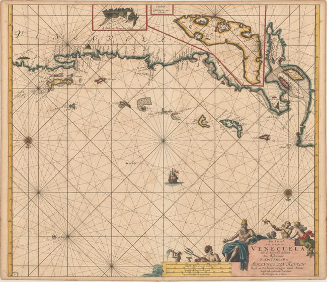
Auction 169, Lot 388
Subject: Venezuela
Keulen/Vooght
Pas-kaart vande Zee Kusten van Venecuela met de Byleggende Eylanden, 1700
Size: 23.1 x 20.2 inches (58.7 x 51.3 cm)
Estimate: $700 - $850
Superb Early Chart of the Venezuelan Coastline Including the ABC Islands
Sold for: $350
Closed on 9/12/2018
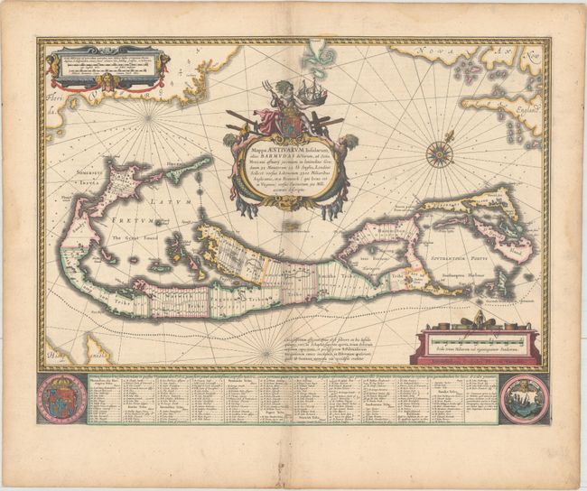
Auction 169, Lot 414
Subject: Bermuda
Blaeu, Willem
Mappa Aestivarum Insularum, Alias Barmudas Dictarum, ad Ostia Mexicani Aestuary..., 1638
Size: 20.9 x 15.9 inches (53.1 x 40.4 cm)
Estimate: $2,000 - $2,300
Map of Bermuda Based on Richard Norwood's Famous Survey
Sold for: $1,400
Closed on 9/12/2018
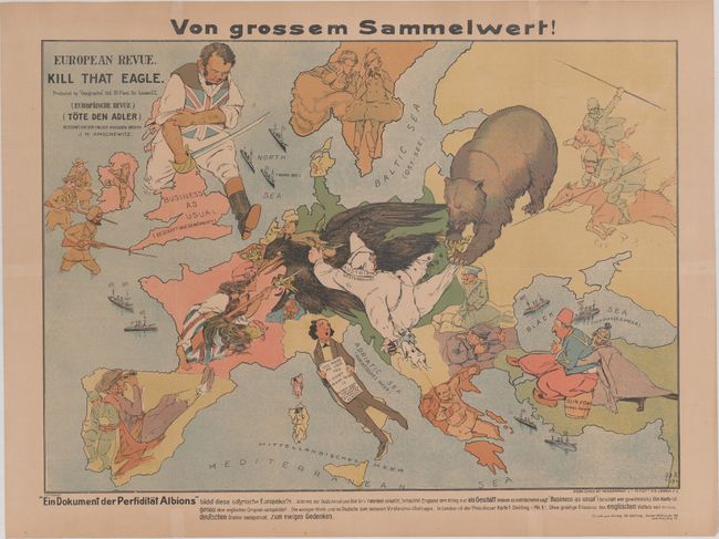
Auction 169, Lot 418
Subject: Europe, World War I
Geographia Map Co
European Revue. Kill That Eagle, 1914
Size: 25.4 x 18 inches (64.5 x 45.7 cm)
Estimate: $2,000 - $2,300
Rare Satirical Map of Europe at Start of World War I
Sold for: $1,500
Closed on 9/12/2018
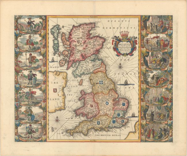
Auction 169, Lot 424
Subject: Britain
Jansson, Jan
Britannia Prout Divisa suit Temporibus Anglo-Saxonum, Praesertim Durante Illorum Heptarchia, 1741
Size: 20.4 x 16.4 inches (51.8 x 41.7 cm)
Estimate: $2,400 - $3,000
Jansson's Splendid Heptarchy Map
Unsold
Closed on 9/12/2018
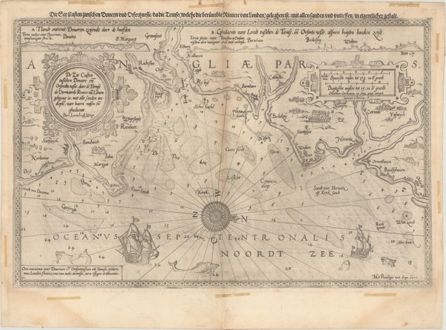
Auction 169, Lot 432
Subject: Southeastern England
Waghenaer, Lucas Jansz
De Zee Custen Tuschen Dovere en Orfordts Nesse, Daer de Teemse de Vermaerde Rivire va Lonen Gelegens is, met Alle Sanden Ondiepte, Naer Haren Wesen en Ghedaente, 1589
Size: 19.9 x 12.8 inches (50.5 x 32.5 cm)
Estimate: $1,000 - $1,300
Rare and Early Sea Chart of the English Coast Near Dover
Sold for: $600
Closed on 9/12/2018
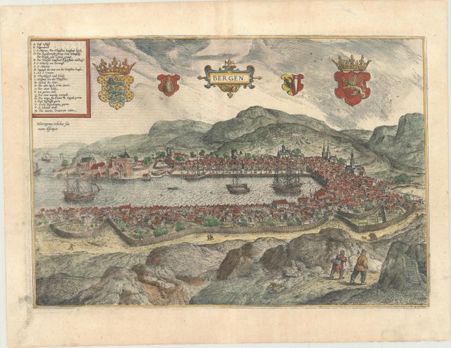
Auction 169, Lot 463
Subject: Bergen, Norway
Braun & Hogenberg
Bergen, 1620
Size: 18.9 x 12.9 inches (48 x 32.8 cm)
Estimate: $1,100 - $1,400
The Only Norwegian City Represented in Braun & Hogenberg's Book of City Views
Sold for: $800
Closed on 9/12/2018
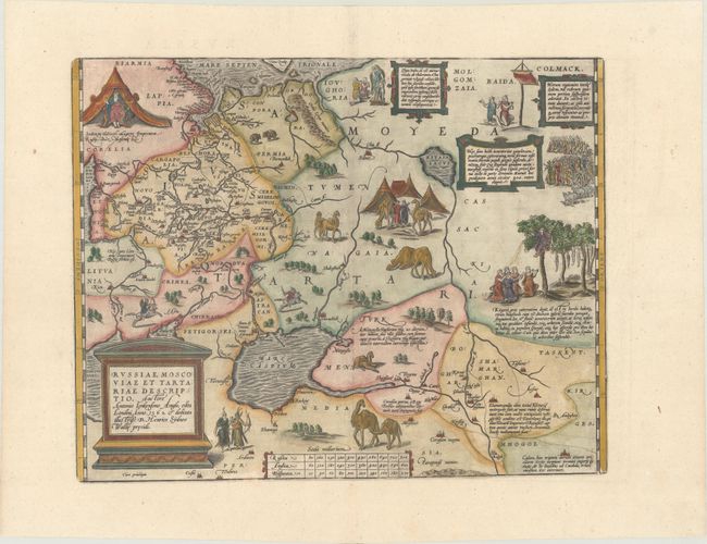
Auction 169, Lot 552
Subject: Russia, Eastern Europe & Central Asia
Ortelius, Abraham
Russiae, Moscoviae et Tartariae Descriptio. Auctore Antonio Ienkensono Anglo..., 1587
Size: 17.6 x 13.9 inches (44.7 x 35.3 cm)
Estimate: $2,000 - $2,300
Ortelius' Map of Russia with a Vignette of Ivan the Terrible
Sold for: $1,800
Closed on 9/12/2018
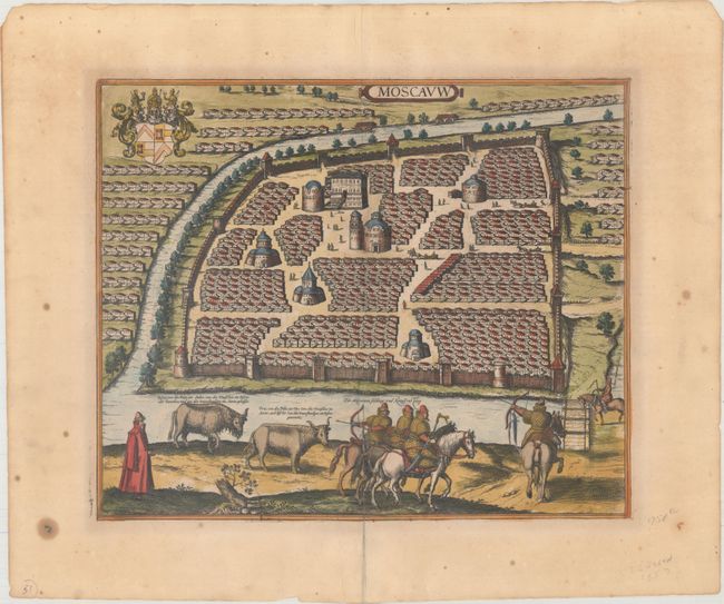
Auction 169, Lot 557
Subject: Moscow, Russia
Jansson, Jan
Moscauw, 1657
Size: 16.6 x 13.7 inches (42.2 x 34.8 cm)
Estimate: $2,300 - $2,750
Rare Jansson Edition of Early Braun & Hogenberg View of Moscow Before the Great Fire
Unsold
Closed on 9/12/2018
63 lots
Page 1 of 2