Subject: St. Augustine, Florida
Period: 1783 (dated)
Publication:
Color: Hand Color
Size:
15.3 x 7.4 inches
38.9 x 18.8 cm
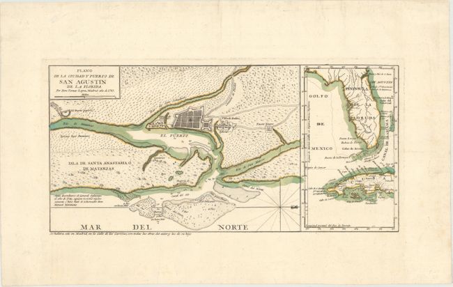
This scarce plan was published by one of the most distinguished Spanish cartographers of the eighteenth century, Lopez de Vargas Machuca (1730-1802), who was Geographer to the King of Spain. Oriented with north to the right, this bird's-eye plan depicts the fortified city of St. Augustine with Indian villages adjacent to the city. A road leads north to Fuerte Negro (Fort Mose) the first legally sanctioned free black community within the present-day borders of the United States. After being brought to Charleston, South Carolina by the British, enslaved Africans who escapeD made their way to St. Augustine, where they were given freedom by the Spaniards. Gracia Real de Santa Teresa de Mose (Fort Mose) was established in 1738 and became the first free black town in the US. At the end of the French and Indian War, the Treaty of Paris of 1763 ceded Florida to Britain, and the Spanish population of Florida, along with the free blacks of Fort Mose, were resettled in Cuba by the Spanish government. An inset map at right depicts Florida and western Cuba. A very uncommon map, as few Spanish maps were ever published.
References: Shirley (BL Atlases) T.LOP-3a, Vol. 2 #18.
Condition: A
Contemporary color on a bright sheet with wide margins and very faint foxing.