Showing Featured Lots(remove filter)
Showing results for:Auction 157
Catalog Archive
77 lots
Page 1 of 2
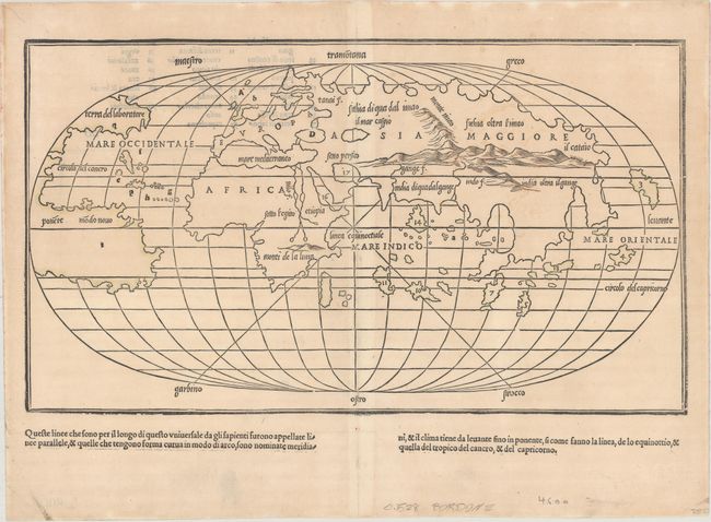
Auction 157, Lot 9
Subject: World
Bordone, Benedetto
[Untitled - World], 1528
Size: 14.9 x 8.5 inches (37.8 x 21.6 cm)
Estimate: $4,000 - $4,750
One of the Earliest World Maps on an Oval Projection
Sold for: $3,000
Closed on 5/4/2016
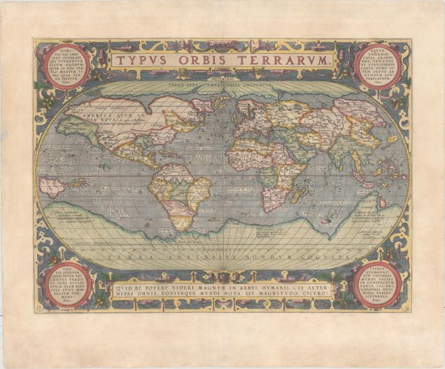
Auction 157, Lot 10
Subject: World
Ortelius, Abraham
Typus Orbis Terrarum, 1587
Size: 19.1 x 13.9 inches (48.5 x 35.3 cm)
Estimate: $7,000 - $8,500
Ortelius' Third World Map in an Oval Projection
Unsold
Closed on 5/4/2016
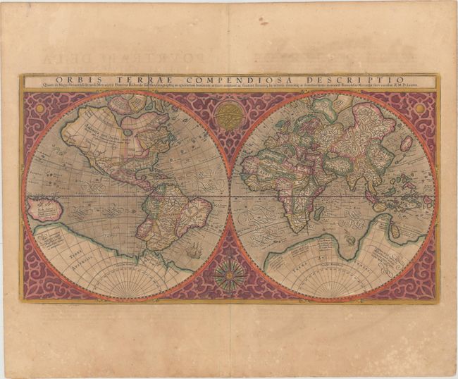
Auction 157, Lot 11
Subject: World
Mercator, Rumold
Orbis Terrae Compendiosa Descriptio quam ex Magna Universali Gerardi Mercatoris Domino Richardo Gartho..., 1587
Size: 20.6 x 11.3 inches (52.3 x 28.7 cm)
Estimate: $4,000 - $4,750
Mercator's Double-Hemisphere World Map in Full Original Color
Unsold
Closed on 5/4/2016
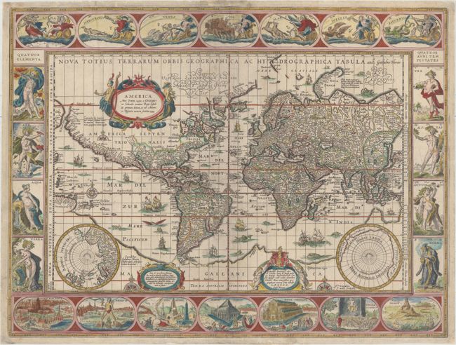
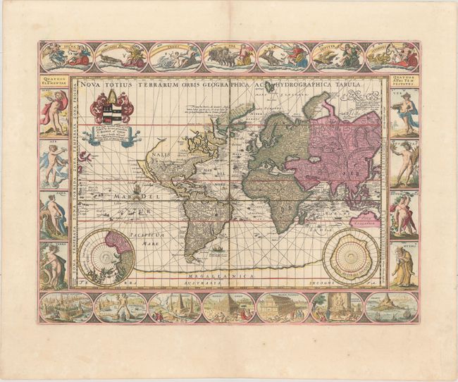
Auction 157, Lot 16
Subject: World
Blaeu, Willem
Nova Totius Terrarum Orbis Geographica ac Hydrographica Tabula, 1640
Size: 21.3 x 16.1 inches (54.1 x 40.9 cm)
Estimate: $12,000 - $14,000
Blaeu's Magnificent Carte-a-Figures World Map with Rare Blank Verso
Unsold
Closed on 5/4/2016
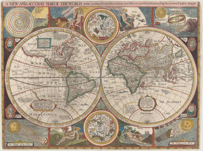
Auction 157, Lot 17
Subject: World
Walton, Robert
A New and Accurat Map of the World Drawne According to ye Truest Descriptions Latest Discoveries & Best Observations yt Have Beene Made by English or Strangers, 1659
Size: 20.6 x 15.5 inches (52.3 x 39.4 cm)
Estimate: $10,000 - $12,000
Pirated Edition of Speed's Map of the World
Unsold
Closed on 5/4/2016
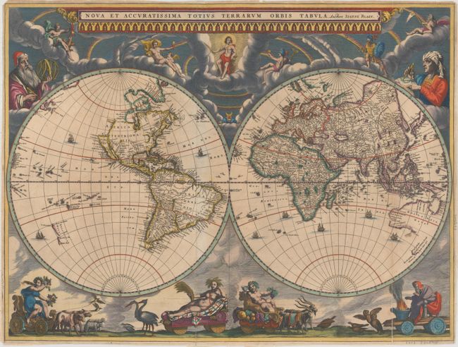
Auction 157, Lot 18
Subject: World
Blaeu, Johannes
Nova et Accuratissima Totius Terrarum Orbis Tabula, 1660
Size: 21.3 x 16.1 inches (54.1 x 40.9 cm)
Estimate: $14,000 - $17,000
Rare Blaeu Double-Hemisphere Map in Full Original Color
Sold for: $10,500
Closed on 5/4/2016
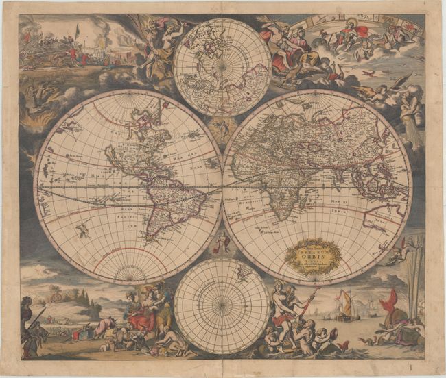
Auction 157, Lot 20
Subject: World
Pitt, Moses
Nova Totius Terrarum Orbis Geographica ac Hydrographica Tabula, 1680
Size: 21.1 x 15.7 inches (53.6 x 39.9 cm)
Estimate: $9,500 - $11,000
Pitt's Rare Carte-a-Figures Map with California as an Island
Sold for: $6,500
Closed on 5/4/2016
Auction 157, Lot 21
Subject: World
Danckerts, Justus
Nova Totius Terrarum Orbis Tabula, 1680
Size: 21.8 x 18.8 inches (55.4 x 47.8 cm)
Estimate: $3,500 - $4,250
Danckerts' Decorative Double-Hemisphere Map
Sold for: $2,200
Closed on 5/4/2016
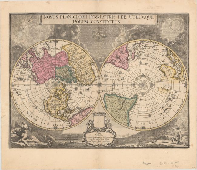
Auction 157, Lot 22
Subject: World
Blaeu/Valck
Novus Planiglobii Terrestris per Utrumque Polum Conspectus, 1695
Size: 21.1 x 15.9 inches (53.6 x 40.4 cm)
Estimate: $5,500 - $7,000
Superb World Map on a Polar Projection
Sold for: $2,750
Closed on 5/4/2016
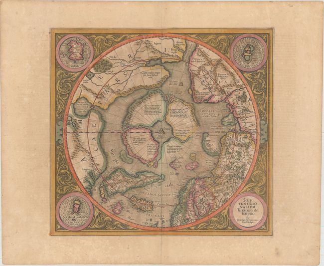
Auction 157, Lot 55
Subject: North Pole
Mercator/Hondius
Septentrionalium Terrarum Descriptio, 1619
Size: 15.4 x 14.5 inches (39.1 x 36.8 cm)
Estimate: $2,000 - $2,300
The First Printed Map Devoted to the Arctic in Full Original Color
Sold for: $2,000
Closed on 5/4/2016
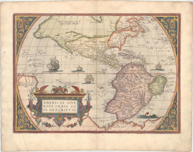
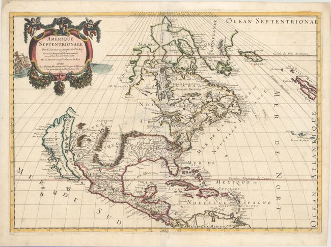
Auction 157, Lot 65
Subject: Western Hemisphere - America
Ortelius, Abraham
Americae sive Novi Orbis, Nova Descriptio, 1571
Size: 20 x 14.6 inches (50.8 x 37.1 cm)
Estimate: $6,000 - $7,000
Rare First Plate of Ortelius' Influential Map of the New World
Sold for: $3,500
Closed on 5/4/2016
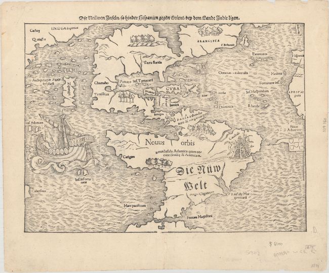
Auction 157, Lot 66
Subject: Western Hemisphere - America
Munster, Sebastian
Die Neuwen Inseln /so Hinder Hispanien Gegen Orient /bey dem Landt Indie Ligen , 1574
Size: 13.6 x 10.1 inches (34.5 x 25.7 cm)
Estimate: $5,500 - $7,000
One of the Most Important 16th Century Maps of the New World
Sold for: $3,500
Closed on 5/4/2016
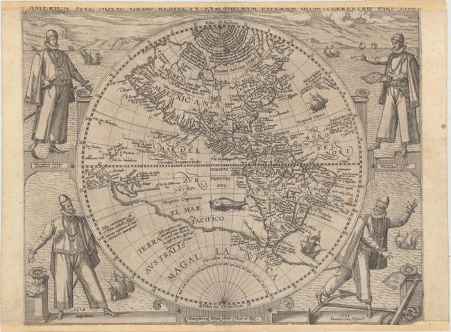
Auction 157, Lot 67
Subject: Western Hemisphere - America
Bry, Theodore de
America sive Novus Orbis Respectu Europaeorum Inferior Globi Terrestris Pars, 1596
Size: 15.8 x 12.5 inches (40.1 x 31.8 cm)
Estimate: $4,000 - $5,000
De Bry's Influential Map of the Americas
Unsold
Closed on 5/4/2016
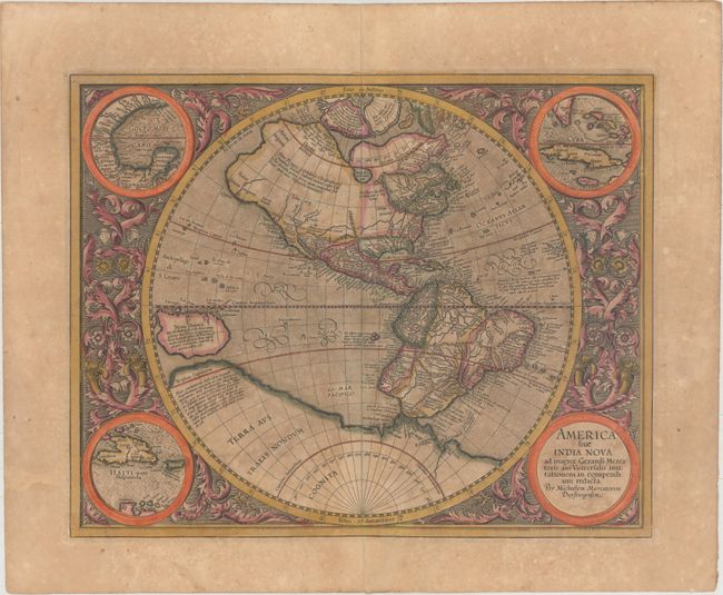
Auction 157, Lot 69
Subject: Western Hemisphere - America
Mercator/Hondius
America sive India Nova, ad Magnae Gerardi Mercatoris aui Universalis Imitationem in Compendium Redacta, 1619
Size: 18.1 x 14.5 inches (46 x 36.8 cm)
Estimate: $3,500 - $4,250
Mercator's Foundation Map for the Americas in Full Original Color
Unsold
Closed on 5/4/2016
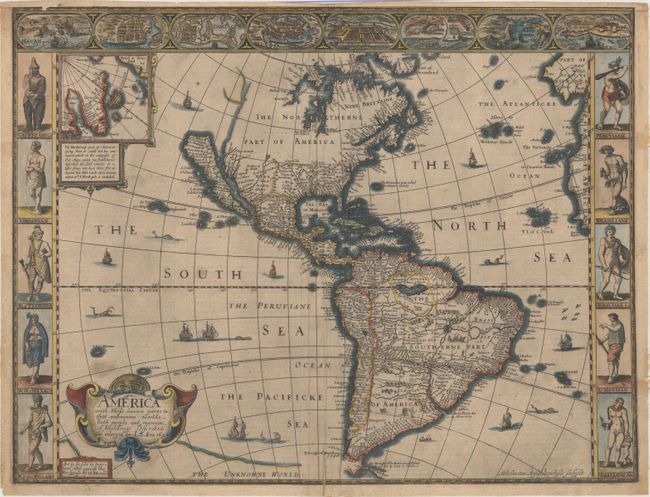
Auction 157, Lot 70
Subject: Western Hemisphere - America
Speed, John
America with Those Known Parts in That Unknowne Worlde Both People and Manner of Buildings Discribed and Inlarged, 1626
Size: 20 x 15.4 inches (50.8 x 39.1 cm)
Estimate: $4,500 - $5,500
Speed's Popular Carte-a-Figures Map of the Americas
Unsold
Closed on 5/4/2016
Auction 157, Lot 72
Subject: Western Hemisphere - America
Hondius, Jodocus
America, 1628
Size: 19.9 x 14.8 inches (50.5 x 37.6 cm)
Estimate: $3,000 - $3,750
Hondius' Important Map of the Americas
Sold for: $2,200
Closed on 5/4/2016
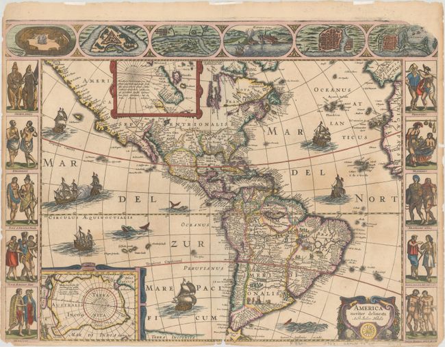
Auction 157, Lot 73
Subject: Western Hemisphere - America
Hondius/Jansson
America Noviter Delineata, 1632
Size: 21.6 x 16.1 inches (54.9 x 40.9 cm)
Estimate: $6,500 - $8,000
Jansson's Rare Carte-a-Figures Map of the Americas
Unsold
Closed on 5/4/2016
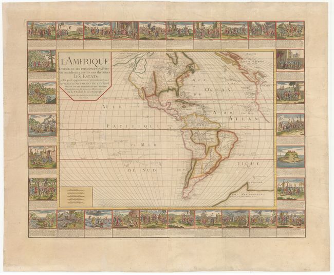
Auction 157, Lot 84
Subject: Western Hemisphere - America
Bailleul, Gaspard
L'Amerique Divisee en Ses Principales Parties ou sont Distingues les uns des Autres les Estats..., 1752
Size: 39.1 x 30.5 inches (99.3 x 77.5 cm)
Estimate: $19,000 - $22,000
Rare French Wall Map Featuring Vignettes of American History
Unsold
Closed on 5/4/2016
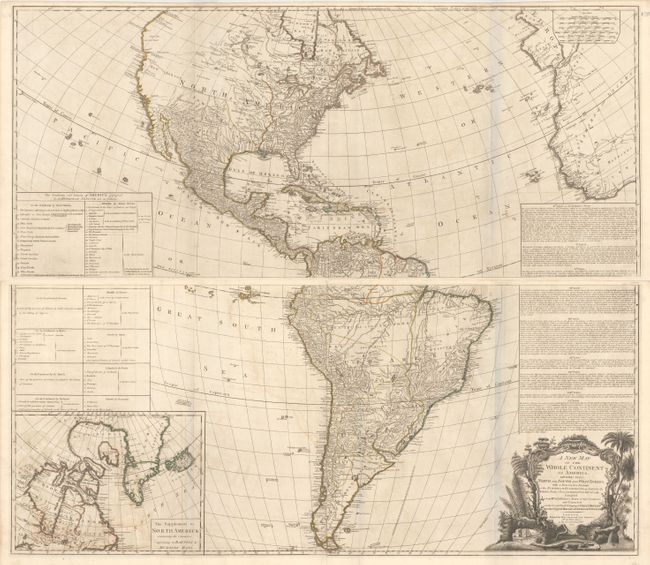
Auction 157, Lot 86
Subject: Western Hemisphere - America
Sayer & Bennett
[On 4 Sheets] A New Map of the Whole Continent of America, Divided into North and South and West Indies. With a Descriptive Account of the European Possessions, as Settled by the Definitive Treaty of Peace..., 1777
Size: 47 x 20.4 inches (119.4 x 51.8 cm)
Estimate: $2,200 - $2,500
Impressive Four-Sheet Map Featuring Two Possible Locations for a River of the West
Sold for: $1,600
Closed on 5/4/2016
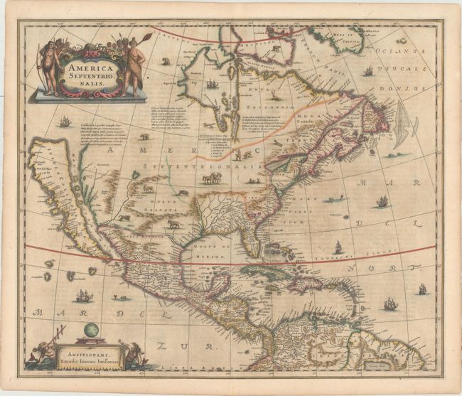
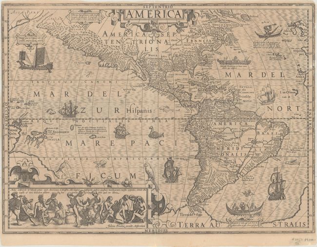
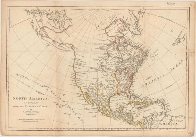
Auction 157, Lot 89
Subject: North America
Hondius/Jansson
America Septentrionalis, 1644
Size: 21.7 x 18.4 inches (55.1 x 46.7 cm)
Estimate: $2,750 - $3,750
One of the Most Important Maps Perpetuating the Myth of the Island of California
Sold for: $2,000
Closed on 5/4/2016
Auction 157, Lot 90
Subject: North America
Sanson/Mariette
Amerique Septentrionale, 1669
Size: 22 x 15.7 inches (55.9 x 39.9 cm)
Estimate: $2,400 - $3,000
Important Map for Great Lakes Collectors
Sold for: $2,400
Closed on 5/4/2016
Auction 157, Lot 93
Subject: North America
Moll, Herman
A New Map of the North Parts of America Claimed by France Under ye Names of Louisiana, Mississipi, Canada and New France with ye Adjoyning Territories of England and Spain..., 1720
Size: 40.3 x 24.3 inches (102.4 x 61.7 cm)
Estimate: $3,500 - $4,250
First State of Moll's Map of North America
Sold for: $2,500
Closed on 5/4/2016
Auction 157, Lot 99
Subject: North America
Sayer & Bennett
[Disbound] The American Military Pocket Atlas; Being an Approved Collection of Correct Maps, Both General and Particular, of the British Colonies; Especially Those Which Now Are, or Probably May Be the Theatre of War..., 1776
Size: See Description
Estimate: $10,000 - $12,000
A Significant Atlas of the American Revolution
Sold for: $6,500
Closed on 5/4/2016
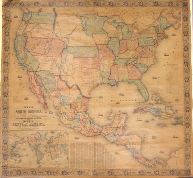
Auction 157, Lot 107
Subject: North America
Monk, Jacob
New Map of that Portion of North America, Exhibiting the United States and Territories, The Canadas, New Brunswick, Nova Scotia, and Mexico also Central America, and the West India Islands. Compiled from the Most Recent Surveys and Authentic Sources, 1854
Size: 59 x 55.8 inches (149.9 x 141.7 cm)
Estimate: $1,400 - $1,800
Large Wall Map Featuring an Enlarged Gold Region of California
Sold for: $850
Closed on 5/4/2016
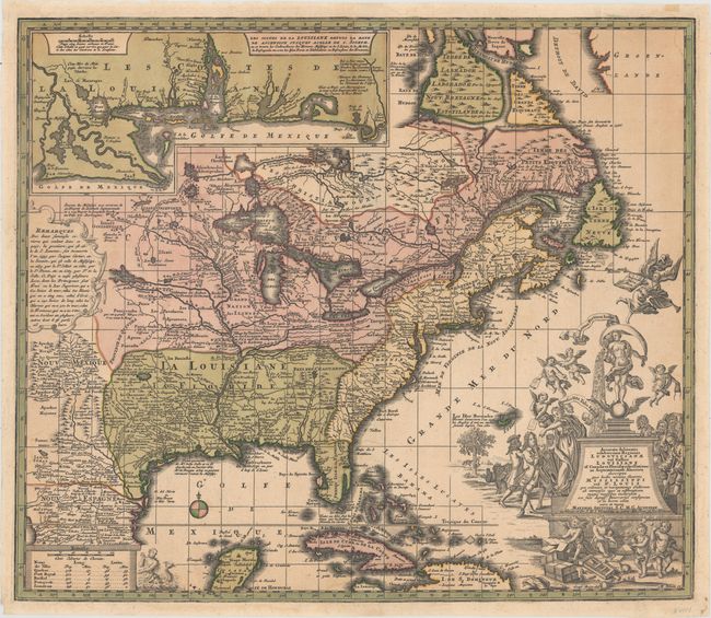
Auction 157, Lot 114
Subject: Colonial North America & Caribbean
Seutter, Matthias
Accurata Delineatio Celeberrimae Regionis Ludovicianae vel Gallice Louisiane ol. Canadae et Floridae Adpellatione in Septemtrionali America Descriptae..., 1728
Size: 22.8 x 19.6 inches (57.9 x 49.8 cm)
Estimate: $2,750 - $3,500
Map Focusing on the Mississippi River and the "Mississippi Bubble"
Sold for: $2,000
Closed on 5/4/2016
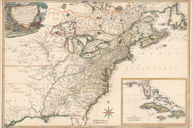
Auction 157, Lot 115
Subject: Colonial North America & Caribbean
Phelipeaux/Brion de la Tour
Carte Generale des Colonies Angloises, dans l'Amerique Septentrionale. Par M. Phelippeaux…, 1778
Size: 30 x 20.5 inches (76.2 x 52.1 cm)
Estimate: $2,750 - $3,500
Rare Separately-Issued Map of the Theater of the American Revolution
Sold for: $2,000
Closed on 5/4/2016
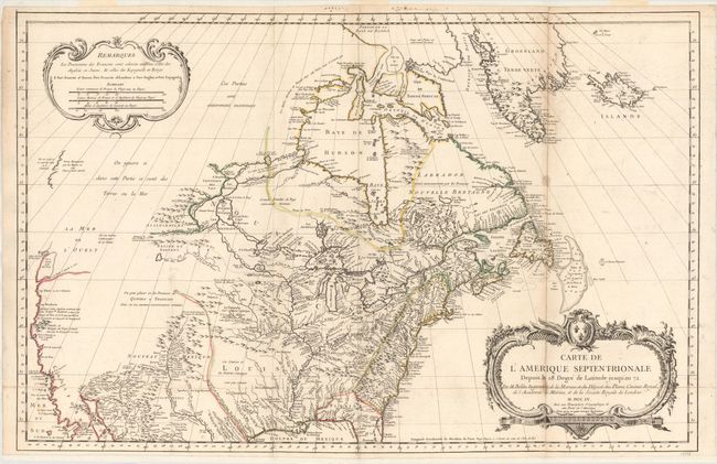
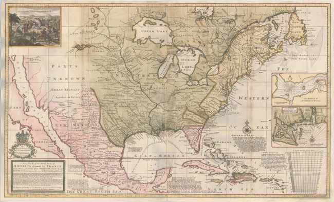
Auction 157, Lot 127
Subject: Colonial United States & Canada
Bellin, Jacques Nicolas
Carte de l'Amerique Septentrionale Depuis le 28 Degre de Latitude Jusqu'au 72, 1755
Size: 34 x 22 inches (86.4 x 55.9 cm)
Estimate: $1,500 - $1,800
NO RESERVE - Bellin's Important, Large Format Map of North America
Sold for: $950
Closed on 5/4/2016
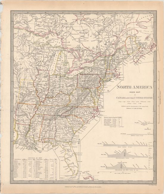
Auction 157, Lot 128
Subject: United States & Canada
SDUK Society for the Diffusion of Useful Knowledge
[Lot of 15 - North America], 1832-34
Size: 12.3 x 15.1 inches (31.2 x 38.4 cm)
Estimate: $950 - $1,200
Matching Set of North America SDUK Maps
Sold for: $1,200
Closed on 5/4/2016
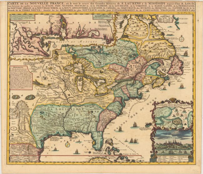
Auction 157, Lot 130
Subject: Colonial Eastern United States & Canada
Chatelain, Henry Abraham
Carte de la Nouvelle France, ou se voit le Cours des Grandes Rivieres de S. Laurens & de Mississipi Aujour d'hui S. Louis, aux Environs des Quelles se Trouvent les Etats, Pais, Nations, Peuples &c..., 1719
Size: 19.1 x 16.6 inches (48.5 x 42.2 cm)
Estimate: $2,200 - $2,500
One of the Most Informative 18th Century Maps of the French Possessions in North America
Sold for: $2,400
Closed on 5/4/2016
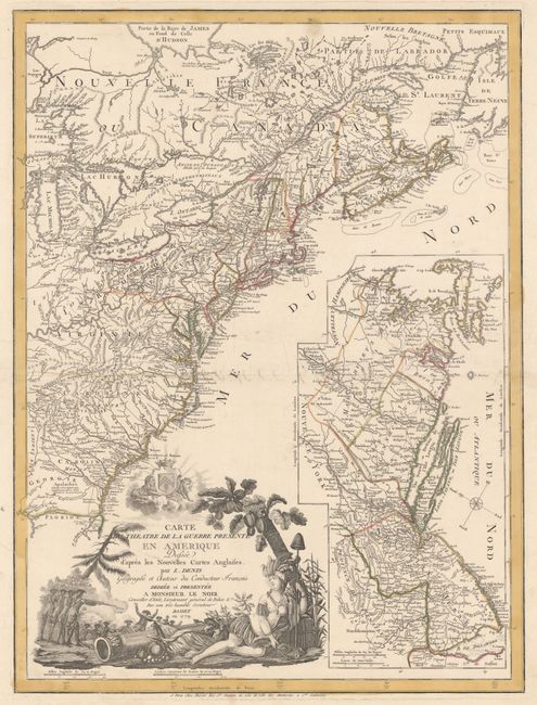
Auction 157, Lot 134
Subject: Colonial Eastern United States & Canada
Denis, Louis
Carte du Theatre de la Guerre Presente en Amerique Dressee d'Apres les Nouvelles Cartes Anglaises..., 1779
Size: 19.8 x 26.3 inches (50.3 x 66.8 cm)
Estimate: $4,750 - $6,000
Scarce American Revolutionary War Map
Sold for: $3,000
Closed on 5/4/2016
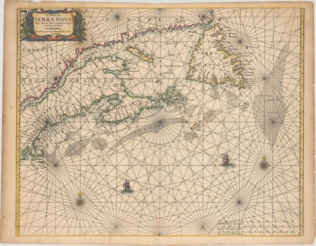
Auction 157, Lot 137
Subject: Canadian Maritimes & New England
Loon, Jan van
Pas-caerte van Terra Nova, Nova Francia, Nieuw Engeland en de Grote Rivier van Canada, 1666
Size: 21.2 x 16.8 inches (53.8 x 42.7 cm)
Estimate: $4,000 - $5,500
Very Influential Dutch Sea Chart of the Canadian Maritimes
Unsold
Closed on 5/4/2016
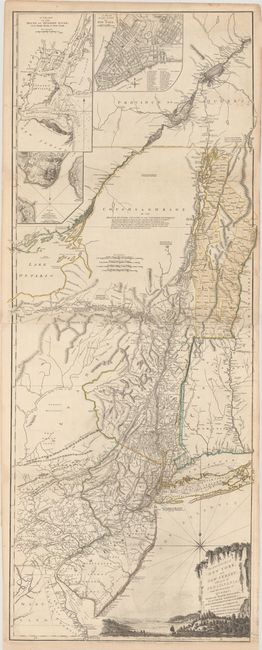
Auction 157, Lot 142
Subject: Colonial Northeastern United States & Quebec
Holland/Pownal
The Provinces of New York and New Jersey; with Part of Pensilvania, and the Province of Quebec, 1776
Size: 21.3 x 52.9 inches (54.1 x 134.4 cm)
Estimate: $5,500 - $7,000
Thomas Jefferys' Important Revolutionary War Period Map
Unsold
Closed on 5/4/2016
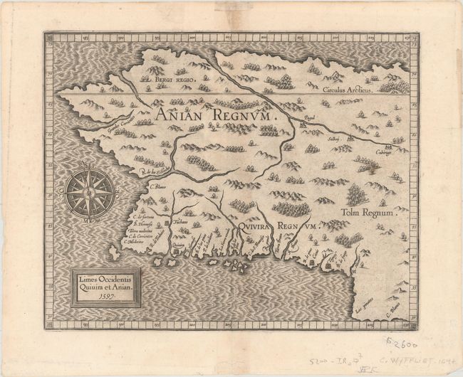
Auction 157, Lot 147
Subject: Alaska & Western Canada
Wytfliet, Cornelis
Limes Occidentis Quivira et Anian, 1597
Size: 11.4 x 9.2 inches (29 x 23.4 cm)
Estimate: $2,200 - $2,500
Early and Imaginary Map of Alaska and the Northwest Passage
Sold for: $1,500
Closed on 5/4/2016
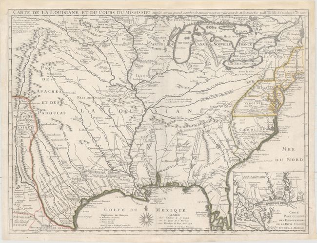
Auction 157, Lot 160
Subject: Colonial Eastern United States
Delisle, Guillaume
Carte de la Louisiane et du Cours du Mississipi Dressee sur un Grand Nombre de Memoires Entr'autres sur ceux de Mr. le Maire, 1718
Size: 25.5 x 19.2 inches (64.8 x 48.8 cm)
Estimate: $10,000 - $12,000
A Foundation Map for the Mississippi Valley and the First Appearance of Texas on a Printed Map
Sold for: $6,000
Closed on 5/4/2016
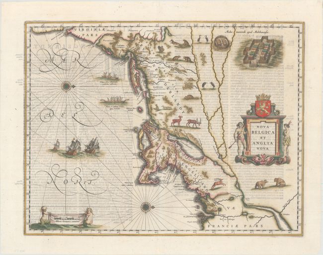
Auction 157, Lot 173
Subject: Colonial New England & Mid-Atlantic
Blaeu, Willem
Nova Belgica et Anglia Nova, 1642
Size: 19.9 x 15.3 inches (50.5 x 38.9 cm)
Estimate: $2,750 - $3,500
Important Map of Colonial New England and the Mid-Atlantic
Sold for: $2,000
Closed on 5/4/2016
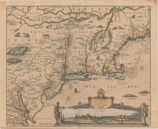
Auction 157, Lot 175
Subject: Colonial New England & Mid-Atlantic
Visscher, Nicolas
Novi Belgii Novaeque Angliae nec non Partis Virginiae Tabula Multis in Locis Emendata, 1684
Size: 21.8 x 18.4 inches (55.4 x 46.7 cm)
Estimate: $6,000 - $7,500
Visscher's Influential Map with Early View of New York City
Sold for: $4,500
Closed on 5/4/2016
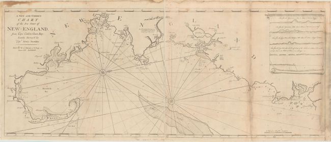
Auction 157, Lot 183
Subject: Colonial New England - United States
Mount & Page
[On 2 Sheets] A New and Correct Chart of the Sea Coast of New-England, from Cape Codd to Casco Bay..., 1764
Size: 23.1 x 18.7 inches (58.7 x 47.5 cm)
Estimate: $3,000 - $3,750
Rare Chart of the Coast of New England by Captain Barnsley
Unsold
Closed on 5/4/2016
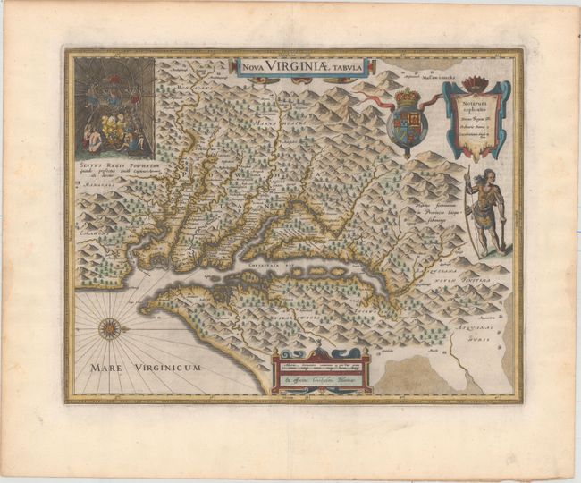
Auction 157, Lot 188
Subject: Colonial Mid-Atlantic United States
Hondius/Blaeu
Nova Virginiae Tabula, 1643
Size: 18.9 x 14.8 inches (48 x 37.6 cm)
Estimate: $2,400 - $3,000
One of the Most Important 17th Century Maps of the Chesapeake Bay
Sold for: $1,800
Closed on 5/4/2016
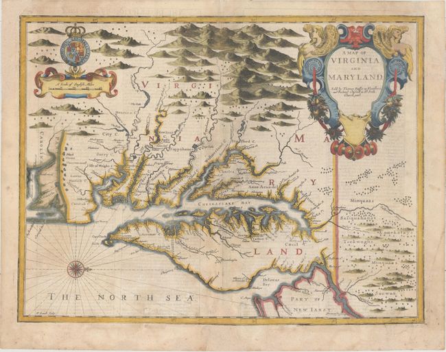
Auction 157, Lot 189
Subject: Colonial Mid-Atlantic United States
Speed/Lamb
A Map of Virginia and Maryland, 1676
Size: 19.6 x 15 inches (49.8 x 38.1 cm)
Estimate: $3,500 - $4,250
The First Printed Map to Draw Upon the Legendary Herrman Map of the Chesapeake Bay
Sold for: $2,500
Closed on 5/4/2016
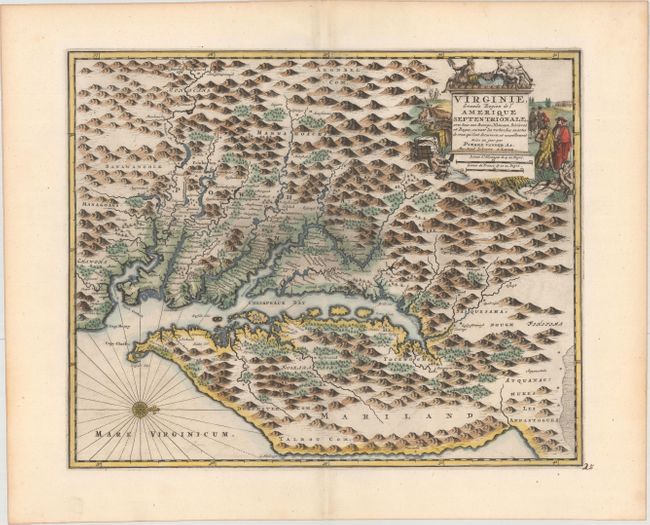
Auction 157, Lot 192
Subject: Colonial Mid-Atlantic United States
Aa, Pieter van der
Virginie, Grande Region de l'Amerique Septentrionale, avec tous Ses Bourgs, Hameaux, Rivieres et Bayes..., 1729
Size: 14.1 x 11.4 inches (35.8 x 29 cm)
Estimate: $1,900 - $2,200
Rare Derivative of John Smith's Map of the Chesapeake Bay
Unsold
Closed on 5/4/2016
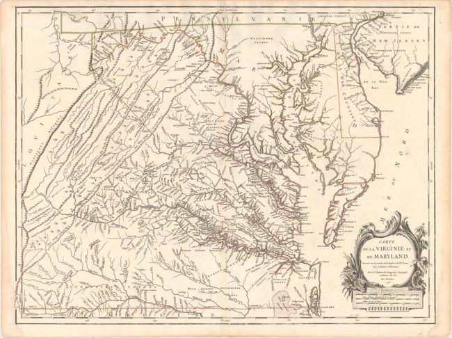
Auction 157, Lot 194
Subject: Colonial Mid-Atlantic United States
Robert de Vaugondy, Didier
Carte de la Virginie et du Maryland Dressee sur la Grande Carte Angloise de Mrs. Josue Fry et Pierre Jefferson..., 1755
Size: 25.4 x 19.1 inches (64.5 x 48.5 cm)
Estimate: $2,750 - $3,500
First State of Robert de Vaugondy's Essential Map of Virginia and Maryland
Sold for: $2,000
Closed on 5/4/2016
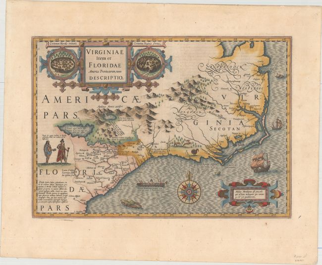
Auction 157, Lot 206
Subject: Colonial Southeast United States
Hondius, Jodocus
Virginiae Item et Floridae Americae Provinciarum, Nova Descriptio, 1638
Size: 19.2 x 13.6 inches (48.8 x 34.5 cm)
Estimate: $2,400 - $3,000
A Seminal Map of the Southeast and Early American Cartography
Sold for: $1,500
Closed on 5/4/2016
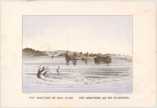
Auction 157, Lot 234
Subject: Mississippi River
Lewis, Henry
[Lot of 14 - Prints of the Mississippi River], 1856
Size: 7.8 x 5.4 inches (19.8 x 13.7 cm)
Estimate: $1,600 - $1,900
Rare, Early Color Plates of the Mississippi River
Sold for: $800
Closed on 5/4/2016
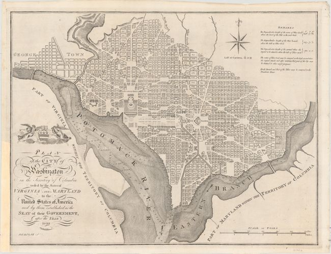
Auction 157, Lot 269
Subject: Washington, D.C.
Reid, John
Plan of the City of Washington in the Territory of Columbia Ceded by the States of Virginia and Maryland to the United States of America and by Them Established as the Seat of Their Government, After the Year 1800, 1796
Size: 20.7 x 15.8 inches (52.6 x 40.1 cm)
Estimate: $2,750 - $3,500
Rare, Early Large Format Map of Washington D.C.
Sold for: $2,000
Closed on 5/4/2016
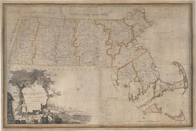
Auction 157, Lot 291
Subject: Massachusetts
Carleton, Osgood
Map of Massachusetts Proper Compiled from Actual Surveys Made by Order of the General Court, and Under the Inspection of Agents of Their Appointment , 1801
Size: 44.9 x 30.3 inches (114 x 77 cm)
Estimate: $12,000 - $14,000
Landmark Map of Massachusetts - First Edition of the First Official Map of the State
Unsold
Closed on 5/4/2016
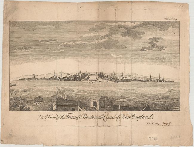
Auction 157, Lot 295
Subject: Boston, Massachusetts
A View of the Town of Boston the Capital of New England, 1787
Size: 9.2 x 4.9 inches (23.4 x 12.4 cm)
Estimate: $800 - $950
Rare Edition of Boston View with American Flag
Unsold
Closed on 5/4/2016
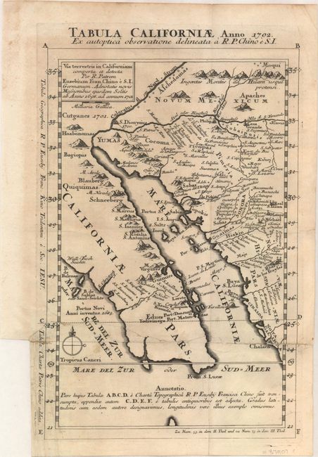
Auction 157, Lot 346
Subject: Southwestern United States & Mexico
Kino, Eusebio Francisco, SJ
Tabula Californiae, Anno 1702. Ex Autoptica Observatione Delineata a R.P. Chino e S.I., 1702
Size: 8.7 x 13.4 inches (22.1 x 34 cm)
Estimate: $1,600 - $2,000
NO RESERVE - Kino's Scarce Second Map of Lower California
Sold for: $500
Closed on 5/4/2016
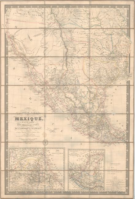
Auction 157, Lot 349
Subject: Western United States & Mexico, Texas, California
Brue, Adrien Hubert
Nouvelle Carte du Mexique, et d'une Partie des Provinces Unies de l'Amerique Centrale..., 1840
Size: 26 x 37.1 inches (66 x 94.2 cm)
Estimate: $6,000 - $7,500
Brue's Landmark Map of the West Featuring the Republic of Texas
Sold for: $2,740
Closed on 5/4/2016
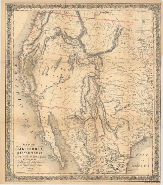
Auction 157, Lot 351
Subject: Western United States & Mexico
Colton, Joseph Hutchins
Map of California, Oregon, Texas, and the Territories Adjoining with Routes &c., 1849
Size: 18.1 x 20.8 inches (46 x 52.8 cm)
Estimate: $1,400 - $1,700
Colton's Map Depicting the Gold Region of California
Sold for: $2,000
Closed on 5/4/2016
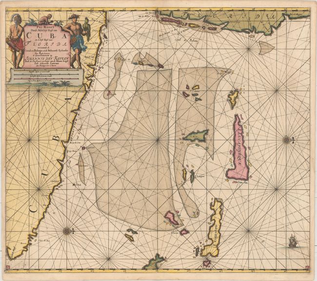
Auction 157, Lot 378
Subject: Cuba, Southeastern Florida, Bahamas
Keulen, Johannes van
Pas Kaart vande Noord Oost Kust van Cuba en d'Oost Kust van Florida Vervaatende de Canal van Bahama met de Bahaamse Eylanden..., 1695
Size: 23.1 x 20.3 inches (58.7 x 51.6 cm)
Estimate: $3,250 - $4,000
Van Keulen's Stunning Chart of Cuba and the Southeast Coast of Florida
Unsold
Closed on 5/4/2016
77 lots
Page 1 of 2