Subject: North America
Period: 1854 (dated)
Publication:
Color: Hand Color
Size:
59 x 55.8 inches
149.9 x 141.7 cm
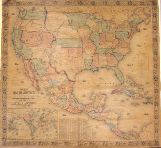
This majestic wall map was published just as the country was beginning to expand fully to the Pacific following the land gains after the Mexican War. The gold region in California is remarkably inaccurate with Auburn shown well north of Sacramento City and lying between it and the Marysville/Yuba City area. The Great Basin area is also inaccurate and roughly follows the Fremont model. Filled with wagon routes, explorer's trails, forts, Indian tribes, and much more. The middle of the country is occupied by the newly organized Kanzas Territory and Nebraska Territory, which stretches from the Missouri River to the Continental Divide. Also features very large, early configurations of Washington, Oregon, Utah and New Mexico territories. Indian Territory is composed of three named areas: Chah-Lahkee, Moscogee and Chahta. This edition also depicts the proposed Gadsden Purchase in present-day southern Arizona in red overprinting - an addition that we have not seen in other Monk examples. Below the main map image is a table of distances and a table of counties and towns with more than 1,200 names, as well as a large inset of the World on Mercator's projection. This spectacular wall map is embellished with decorative borders and numerous engraved sailing and steam/sail ships in the oceans. Printed and published by Hoen & Company, Baltimore. Original linen backing, rollers not present.
References: cf. Wheat (TMW) #794; cf. Wheat (GOLD) 243.
Condition: B+
The map is overall bright, mostly clean, and in very good condition. Typical for wall maps of this size, there are numerous small cracks and a few minor chips in the image as well as some chipping in the left and right blank margins. The varnish is toned, as to be expected. There are also a few damp stains confined to the left decorative border. An overall nice example.