Subject: Western United States & Mexico, Texas, California
Period: 1840 (dated)
Publication:
Color: Hand Color
Size:
26 x 37.1 inches
66 x 94.2 cm
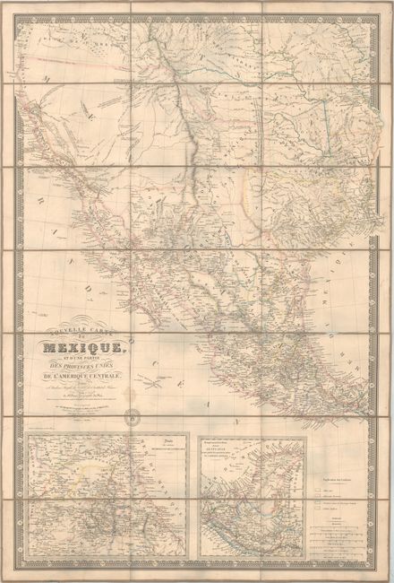
This is the fifth revised edition of Brue's 1834 landmark map of the West and presumably the first edition to depict the Republic of Texas. It was separately issued and published posthumously by Charles Picquet. The map is significant for its depiction of Jedediah Smith's travels in the Great Basin region, showing his route with a solid line from just south of Lac Teguayo (Great Salt Lake) southwest to approximately San Diego, north to R. Wimmelche near the San Joaquin River, and east back to Lac Teguayo, crossing over Mt. St. Joseph (Lassen Peak in northern California) along the way. Wheat describes the first edition of this map as "one of the foundation stones of western mapping" for "it was the first attempt to show the route of Smith's magnificent trek." In addition to Smith's route, the map shows the mythical Lac Timapanogos connecting to the Multnomah River and presumably on to the Pacific Ocean.
This 1840 example is also significant for its depiction of the Republic of Texas, which is shown in its smaller configuration along the Nueces River. A growing network of roads and wagon trails are depicted from the Red River to points south, and numerous settlements are named including San Antonio de Bexar, San Felipe de Austin, Houston, Nashville and Matagorda to name a few. The map shows a very early railroad connecting Galveston Bay to Columbia and also makes note of a Mexican Garrison just north of Tenoxtitlan. Includes inset maps of the eastern Mexican coast and Central America at bottom.
The map is surrounded by a decorative keyboard-style border that indicates longitude from Paris along with Picquet's seal to the right of the title cartouche. Dissected into 21 panels and backed with original linen.
References: cf. Wheat (TMW) #404; cf. Rumsey #5386.
Condition: B
Issued folding with original outline color. There is minor toning, faint offsetting, and several small worm tracks primarily in the right third of the image. A number of creases and unobtrusive cracks along the border and into the map image were likely the result of misfolds. There are two small damp stains to the right of the title with overall minor soiling.