Subject: Massachusetts
Period: 1801 (dated)
Publication:
Color: Hand Color
Size:
44.9 x 30.3 inches
114 x 77 cm
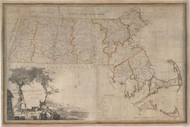
This important piece was the first official map of the state of Massachusetts. At the end of the American Revolution, it was necessary for states to conduct new surveys to create up-to-date maps for the purposes of commerce, settlement, and the further development of transportation networks. Neither the federal nor state governments possessed sufficient funds to support this endeavor, and states were therefore required to find creative ways to fund these updated maps. In 1790, Carleton Osgood proposed to the Massachusetts State Legislature that each town be held responsible for submitting newly surveyed plans of their township, which could then be assembled into a state map. The General Court of Massachusetts approved this plan in 1794, and towns began working on their surveys and plans, which were required to include both geographic and commercial information.
Of course this strategy was imperfect, as not all towns had surveyors, and many submitted incomplete or inaccurate plans. Despite these limitations, Carleton hired John Norman to engrave the map, which was completed in 1798. The General Court rejected the new map due to the numerous errors and poor execution, and Carleton and Norman were forced to sell the 400 copies they had printed elsewhere.
Undeterred, Carleton hired printers B. & J. Loring to publish a new edition. Engravers Joseph Callendar and Samuel Hill were employed to engrave new plates, which were completed in 1801, with 500 copies printed. The General Court accepted this new plan and endorsed it as the official plan for the state. A second edition was published in 1802, and a later edition appeared in 1822 by Amos Lay.
The map is based primarily on new surveys and depicts town and county boundaries, roads, academies, court houses, falls, bridges and more, which are identified in a key at bottom. Norfolk County, which was created in 1793 from the majority of Suffolk County, extends to include both counties. Although Suffolk County is not delineated, a note to the east of Boston explains that the county is comprised of the towns of Boston, Chelsea, Hingham and Hull. The dramatic title cartouche is surrounded by trees with a seaside village in the background, and features a Native American warrior and objects illustrating the important maritime industry.
Printed on four sheets, joined. The first state of this map is very rare and is typically found with significant condition issues.
References: McCorkle #M798.1; Phillips (America) p. 400; Ristow, pp. 89-92; Wheat and Brun #214.
Condition: B
There is moderate soiling, some small abrasions, and a number of cracks, as is typical with these types of wall maps. There are some small chips that have been professionally repaired, with the image skillfully replaced in facsimile, particularly in Worcester County. The map has been trimmed to just inside the neatline, with the entire neatline replaced in facsimile. Laid on old, but not original, linen.