Subject: Washington, D.C.
Period: 1796 (circa)
Publication: The American Atlas
Color: Black & White
Size:
20.7 x 15.8 inches
52.6 x 40.1 cm
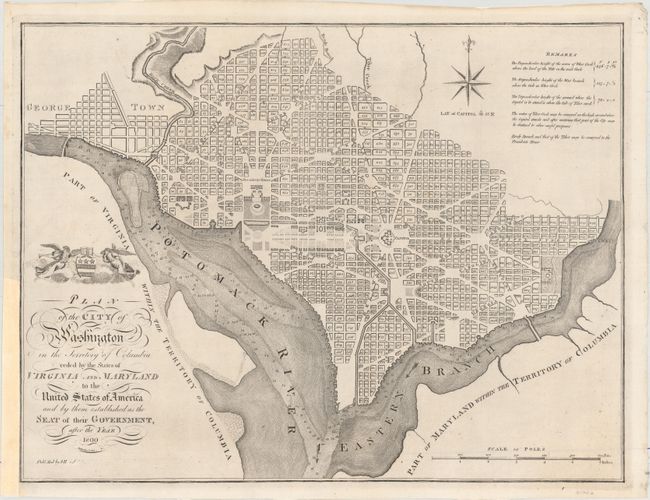
This map is based on the 1792 plan published by Andrew Ellicott. It is among the larger of the maps issued during the city's development. The plan shows the layout of streets including the long diagonals. Washington is bordered by the Potomack (Potomac) River and the Eastern Branch, now the Anacostia River. Georgetown, at the left and northwest of Rock Creek, is separately labeled. Reedy Branch and Tiber Creek are shown to the north outside of the street pattern. Each block is numbered. A few major buildings including the Capitol and the Presidents House are labeled; others are merely outlined. The proposed landscape design for the Mall is shown with considerable detail. Outline contours of docks and slips are shown along the rivers. Near the upper right is an eight-pointed compass indicator surmounted by a fleur-de-lys. Above the title is George Washington’s coat of arms supported by Fame and Liberty. At the lower right is a distance Scale of Poles. Remarks in the upper right lists the elevation of various locations in relation to the tide of Tiber Creek and how water could be provided to the city.
This is William Rollinson's version of the Ellicott plan of Washington that was published as part of John Reid's An American Atlas, which contained the maps to accompany William Winterbotham's An Historical, Geographical, Commercial and Philosophical View of the American United States. This is the second state of the Reid plan, as evidenced by the erasure of "Wayland and C. Smith 1795" from the imprint at bottom left.
References: Phillips (DC) #PW 34; Phillips (M) p. 1005; Baynton-Williams, “Plans of Washington, D.C.”, MapForum.com, Issue 12, map 13b; Howes #W581.
Condition: B+
A crisp impression on watermarked paper. Issued folding, now pressed and professionally backed in tissue to reinforce the folds. A binding trim at bottom left has been replaced with paper, and an associated binding tear that enters 2" into a blank area above the title cartouche has been professionally repaired.