Subject: Colonial North America & Caribbean
Period: 1778 (dated)
Publication:
Color: Hand Color
Size:
30 x 20.5 inches
76.2 x 52.1 cm
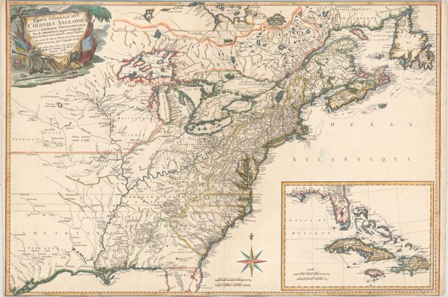
This is the second edition of a rare map issued when the Treaty of Alliance between France and the United States brought heightened awareness of the American Revolution to the French public. The map was first issued in 1777 with the title, Carte Detaillee des Possessions Angloises dans l'Amerique Septentrionale. The geography remains the same, covering the eastern half of North America from Hudson Bay to the Gulf of Mexico and includes an inset of southern Florida, the Bahamas, and the Greater Antilles. Based on the great Mitchell map of 1755, it presents very good detail of the colonies, cities and towns, forts, roads, Indian villages and tribal territory, and along the coastlines it depicts shoals and banks. Georgia is oddly shaped and incorporates much of present-day northern Florida. North Carolina and Virginia are shown with their boundaries extending west off the map. The information regarding the Indian territories and trading paths west of the Appalachian Mountains is excellent. A military scene with cannons and banners forms the title cartouche. Published by Esnauts and Rapilly. All editions are rarely seen on the market.
References: McCorkle #778.12; Sellers & Van Ee #151.
Condition: B
A clean and bright example with a crisp impression on watermarked paper. The top and bottom margins have been trimmed to the neatline and there are professional minor repairs on the centerfold. With the exception of the trimmed margins this would be an "A" example.