Subject: Mid-Atlantic United States, Civil War
Period: 1861 (dated)
Publication:
Color: Printed Color
Size:
28.1 x 18.1 inches
71.4 x 46 cm
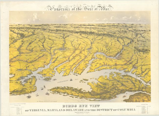
This scare bird's-eye view was one of six Confederate "Seat of War" maps produced by Bachmann and is taken from an "aerial" perspective in the Atlantic Ocean. Noted as "drawn from nature," the beautiful view depicts the region from Portsmouth and Suffolk north to Baltimore and Washington. It locates Richmond, Ft. Monroe, Petersburg, Fredericksburg, Harper's Ferry, and many more. Battle sites are marked by crossed swords, including the earliest Civil War land battles at Bunker Hill, Romney, and Laurel Hill in present-day West Virginia, along with sites in northern Virginia including Fairfax, Vienna, and Bull Run. This is the second state of the map as evidenced by the billowing smoke around Manassas battlefield. Sailboats and steamships fill the Chesapeake and Delaware bays and two tables of distances are located below the view. Published by Bachmann at 115 & 117 Nassau St., New York. Sheet size measures 31.2 x 22.6".
Reps concluded that "No finer artist of city views worked in America than John Bachmann. Unfortunately, there is no artist about whom less is known."
References: Reps (Views) p. 160; Stephenson (Civil War) #3; Stephenson & McKee p. 239; Wooldridge p. 261-2.
Condition: B+
On a bright sheet that has been remargined at left. There are minor edge tears along the top and bottom sheet edges that have been closed on verso with archival tape.