Showing Featured Lots(remove filter)
Filtered by Category:United States(Show All Categories)
Showing results for:Auction 138
Catalog Archive
27 lots
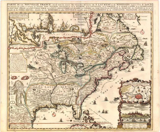
Auction 138, Lot 133
Subject: Colonial United States and Canada
Chatelain, Henry Abraham
Carte de la Nouvelle France, ou se voit le cours des Grandes Rivieres de S. Laurens & de Mississipi Aujour d'hui S. Louis, Aux Environs des-quelles se trouvent les Etats, Pais, Nations, Peuples &c., 1719
Size: 19 x 16.5 inches (48.3 x 41.9 cm)
Estimate: $2,500 - $3,250
Sold for: $1,900
Closed on 12/7/2011
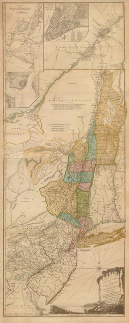
Auction 138, Lot 140
Subject: Colonial Northeast and Quebec
Sayer & Bennett
The Provinces of New York, and New Jersey; with Part of Pensilvania, and the Province of Quebec. Drawn by Major Holland…, 1776
Size: 20.5 x 53 inches (52.1 x 134.6 cm)
Estimate: $5,500 - $6,500
Thomas Jefferys' Important Revolutionary War Period Map
Unsold
Closed on 12/7/2011
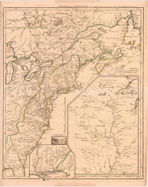
Auction 138, Lot 149
Subject: Eastern Colonial United States and Canada
Le Rouge, George Louis
Canada et Louisiane, 1755
Size: 19.8 x 24.3 inches (50.3 x 61.7 cm)
Estimate: $2,200 - $3,000
Unsold
Closed on 12/7/2011
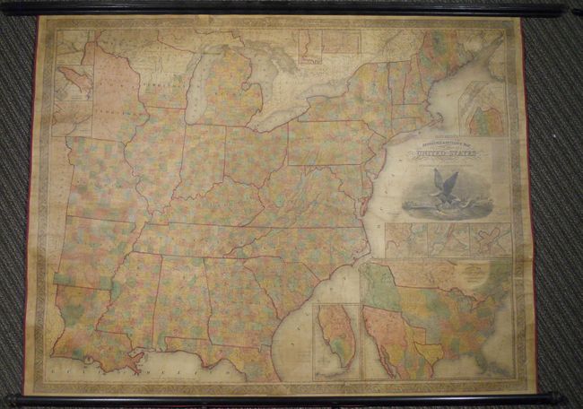
Auction 138, Lot 160
Subject: United States, Republic of Texas
Mitchell, Samuel Augustus
Mitchell's Reference & Distance Map of the United States, 1844
Size: 67 x 52.5 inches (170.2 x 133.4 cm)
Estimate: $6,000 - $8,000
Exceptional Wall Map Featuring the Independent Republic of Texas - 1844
Sold for: $3,000
Closed on 12/7/2011
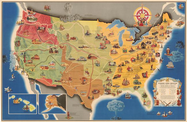
Auction 138, Lot 173
Subject: United States
Standard School Broadcast Pictorial Music - Map of the United States of America…, 1949
Size: 40 x 26 inches (101.6 x 66 cm)
Estimate: $400 - $500
Unusual Thematic Map of the United States
Sold for: $425
Closed on 12/7/2011
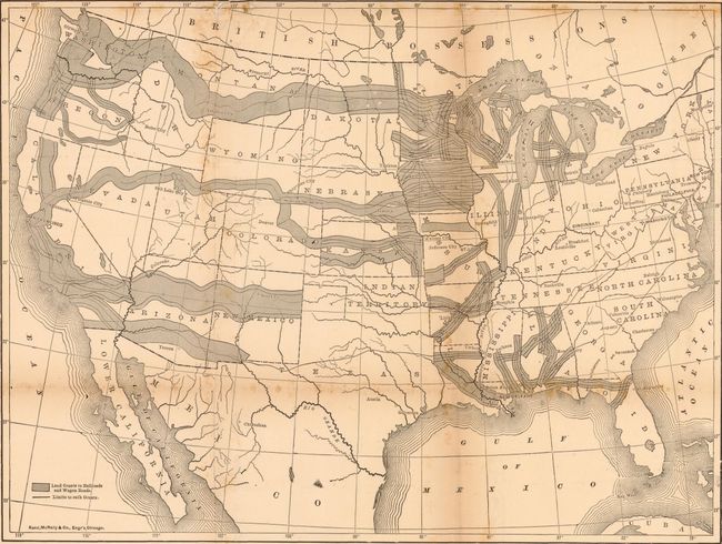
Auction 138, Lot 175
Subject: United States, Railroads
Rand McNally & Co.
How the Public Domain Has Been Squandered…, 1884
Size: 15.5 x 20.5 inches (39.4 x 52.1 cm)
Estimate: $750 - $900
Superb Example of Political Propaganda and Thematic Mapping
Sold for: $450
Closed on 12/7/2011
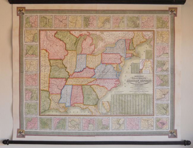
Auction 138, Lot 186
Subject: Eastern United States
Mitchell, Samuel Augustus
Mitchell's National Map of the American Republic or United States of North America, Together with Maps of the Vicinities of Thirty-Two of the Principal Cities and Towns in the Union, 1843
Size: 47 x 38 inches (119.4 x 96.5 cm)
Estimate: $2,400 - $3,000
Remarkable Example of Mitchell's Wall Map
Unsold
Closed on 12/7/2011
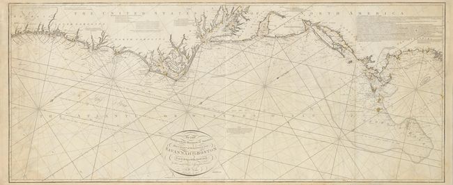
Auction 138, Lot 188
Subject: Eastern United States
Norie, John William
To the Independent Mariners of America, This Chart of their Coast from Savannah to Boston is most Respectfully Dedicated…, 1852
Size: 61 x 25.3 inches (154.9 x 64.3 cm)
Estimate: $2,400 - $3,000
Unsold
Closed on 12/7/2011
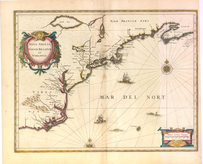
Auction 138, Lot 190
Subject: Colonial New England and Mid-Atlantic
Jansson, Jan
Nova Anglia Novum Belgium et Virginia, 1636
Size: 20 x 15.3 inches (50.8 x 38.9 cm)
Estimate: $1,900 - $2,200
Jansson's influential map of the East Coast
Unsold
Closed on 12/7/2011
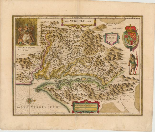
Auction 138, Lot 196
Subject: Colonial Mid-Atlantic
Hondius, Henricus
Nova Virginiae Tabula, 1639
Size: 19.5 x 15 inches (49.5 x 38.1 cm)
Estimate: $2,400 - $3,000
One of the most important 17th century maps of the Chesapeake Bay
Sold for: $1,700
Closed on 12/7/2011
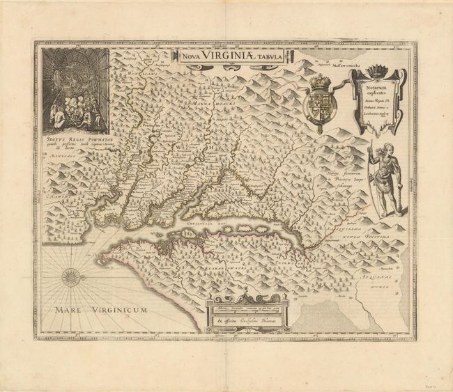
Auction 138, Lot 197
Subject: Colonial Mid-Atlantic
Hondius/Blaeu
Nova Virginiae Tabula, 1642
Size: 19 x 15 inches (48.3 x 38.1 cm)
Estimate: $2,750 - $3,500
One of the Most Important 17th Century Maps of the Chesapeake Bay
Unsold
Closed on 12/7/2011
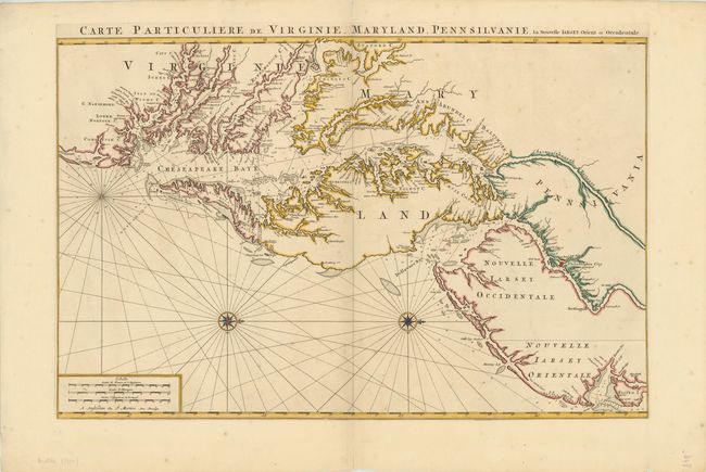
Auction 138, Lot 200
Subject: Colonial Mid-Atlantic
Jaillot/Mortier
Carte Particuliere de Virginie, Maryland, Pennsilvanie, la Nouvelle Iarsey Orient et Occidental, 1700
Size: 31.5 x 20.5 inches (80 x 52.1 cm)
Estimate: $7,000 - $9,000
One of the Most Beautiful Charts of Maryland and the Chesapeake Bay
Unsold
Closed on 12/7/2011
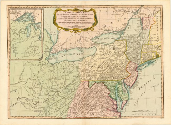
Auction 138, Lot 207
Subject: Mid-Atlantic United States & Great Lakes
Laurie & Whittle
A New and General Map of the Middle Dominions Belonging to the United States of America, viz. Virginia, Maryland, the Delaware-Counties, Pennsylvania, New Jersey &c. with the Addition of New York, & of the Greatest Part of New England…, 1794
Size: 26 x 18.8 inches (66 x 47.8 cm)
Estimate: $1,500 - $1,800
Laurie & Whittle's Popular Map Depicting the "New" United States
Sold for: $1,200
Closed on 12/7/2011

Auction 138, Lot 218
Subject: Colonial South
Gerritsz/De Laet
Florida, et Regiones Vicinae, 1630
Size: 14 x 11.3 inches (35.6 x 28.7 cm)
Estimate: $3,750 - $4,500
De Laet's Important Map of the South
Sold for: $3,000
Closed on 12/7/2011
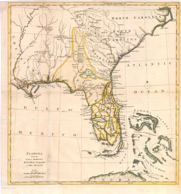
Auction 138, Lot 220
Subject: Southern United States
Jefferys, Thomas
Florida from the Latest Authorities, 1763
Size: 14 x 15 inches (35.6 x 38.1 cm)
Estimate: $1,300 - $1,500
Scarce, Important Map Showing the New British Possession of Florida
Sold for: $2,200
Closed on 12/7/2011
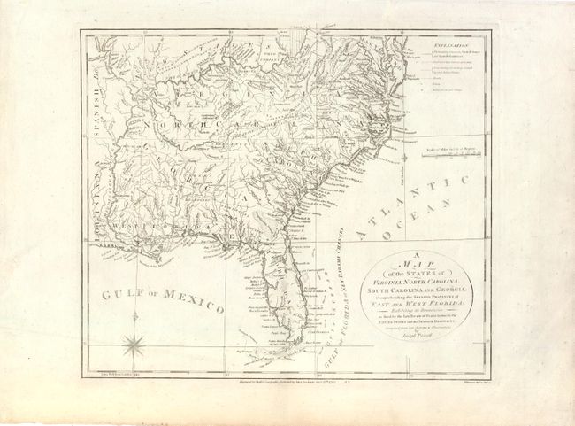
Auction 138, Lot 221
Subject: Southern United States
Purcell, Joseph
A Map of the States of Virginia, North Carolina, South Carolina and Georgia: Comprehending the Spanish Provinces of East and West Florida: Exhibiting the Boundaries as Fixed by the Late Treaty of Peace Between the United States and the Spanish Dominions, 1792
Size: 14.5 x 12.5 inches (36.8 x 31.8 cm)
Estimate: $800 - $1,000
An Early Map Locating the Proposed State of Franklin
Sold for: $800
Closed on 12/7/2011
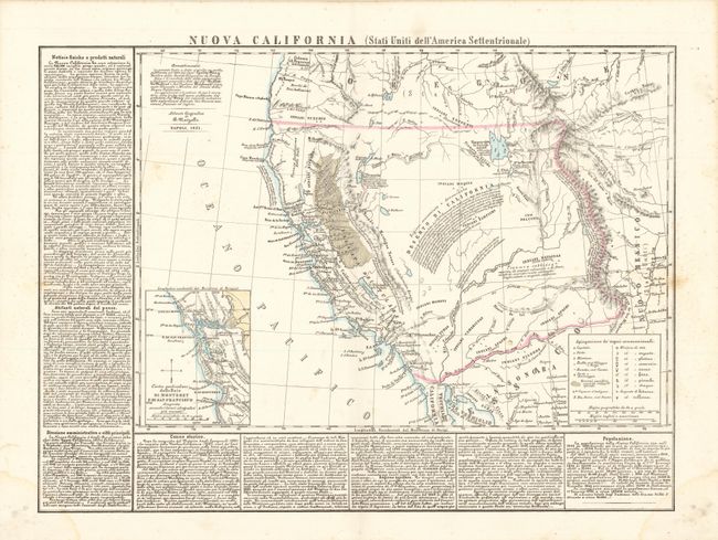
Auction 138, Lot 237
Subject: Western United States
Marzolla, Benedetto
Nuova California (Stati Uniti dell'America Settentrionale), 1851
Size: 23.3 x 17 inches (59.2 x 43.2 cm)
Estimate: $1,600 - $2,000
A Collector's Item for the California Gold Rush Region
Unsold
Closed on 12/7/2011
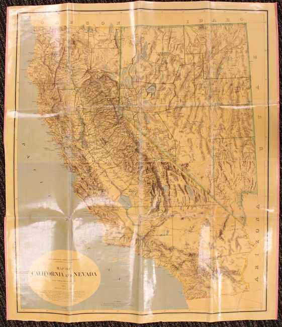
Auction 138, Lot 248
Subject: Western United States, California, Nevada
Map of California and Nevada, 1874
Size: 34 x 40.5 inches (86.4 x 102.9 cm)
Estimate: $1,000 - $1,300
Important Map from the First Scientific Survey of California
Sold for: $700
Closed on 12/7/2011
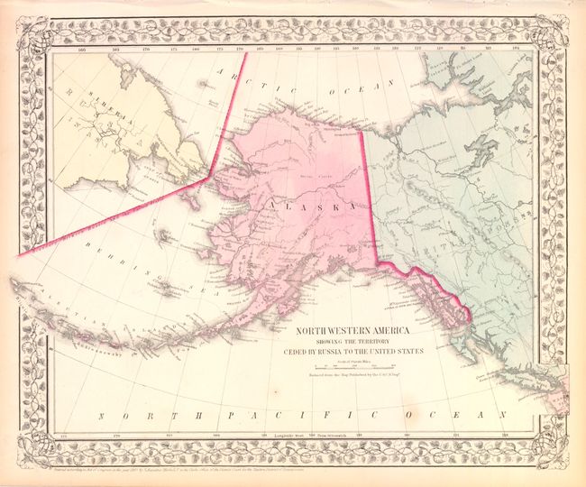
Auction 138, Lot 265
Subject: Alaska
Mitchell, Samuel Augustus
North Western America Showing the Territory Ceded by Russia to the United States, 1867
Size: 14.3 x 11.5 inches (36.3 x 29.2 cm)
Estimate: $100 - $130
One of the First Atlas Maps of Alaska Territory
Sold for: $75
Closed on 12/7/2011
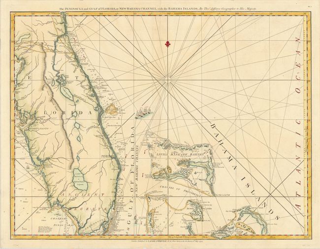
Auction 138, Lot 286
Subject: Florida
Jefferys/Laurie & Whittle
The Peninsula and Gulf of Florida, or New Bahama Channel, with the Bahama Islands, 1794
Size: 24.8 x 19 inches (63 x 48.3 cm)
Estimate: $1,600 - $2,000
Sold for: $1,000
Closed on 12/7/2011
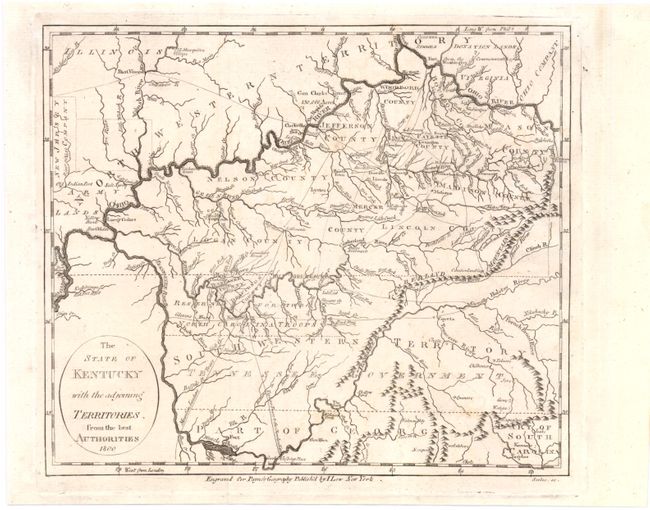
Auction 138, Lot 299
Subject: Kentucky & Tennessee
Payne, John
The State of Kentucky with the Adjoining Territories from the Best Authorities, 1800
Size: 8.5 x 7.5 inches (21.6 x 19.1 cm)
Estimate: $350 - $450
Nice example showing Bounty Land Grants
Sold for: $275
Closed on 12/7/2011
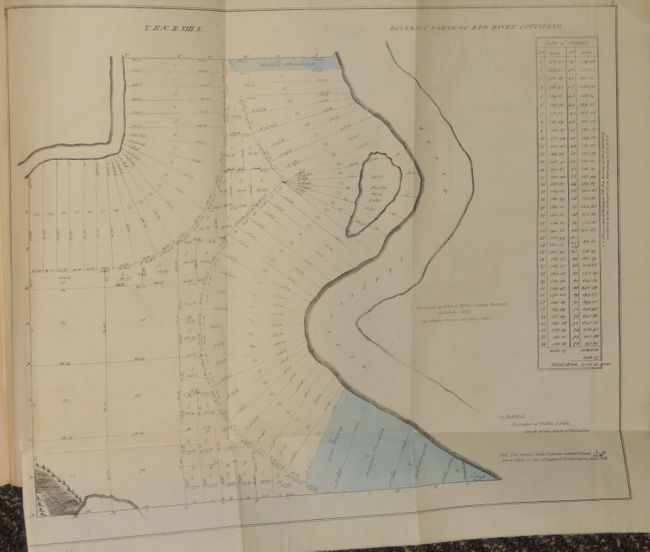
Auction 138, Lot 301
Subject: Louisiana
Third Report from the Select Committee on Emigration from the United Kingdom, 1827
Size: 8.5 x 13.2 inches (21.6 x 33.5 cm)
Estimate: $1,500 - $2,200
Rare Parliamentary Report Regarding Emigration from Britain to the United States
Sold for: $850
Closed on 12/7/2011
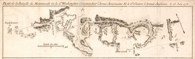
Auction 138, Lot 312
Subject: Monmouth, New Jersey
Plan de la Bataille de Montmouth ou le Gl. Washington Commandait l'Armee Americaine et le Gl. Clinton l'Armee Anglaise, le 28 Juin 1778, 1782
Size: 15.3 x 4.3 inches (38.9 x 10.9 cm)
Estimate: $1,400 - $1,700
An Important Battle Plan of the American Revolution
Sold for: $1,000
Closed on 12/7/2011
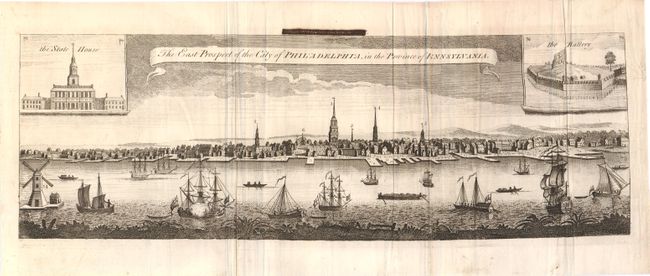
Auction 138, Lot 330
Subject: Philadelphia, Pennsylvania
London Magazine
The East Prospect of the City of Philadelphia, in the Providence of Pennsylvania, 1761
Size: 19.5 x 6.5 inches (49.5 x 16.5 cm)
Estimate: $750 - $1,000
Rare Early City View of Philadelphia
Sold for: $500
Closed on 12/7/2011
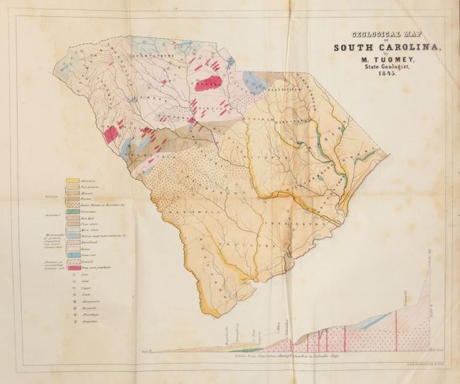
Auction 138, Lot 336
Subject: South Carolina
Tuomey, Michael
Geological Map of South Carolina, by M. Tuomey, State Geologist, 1845, 1848
Size: 9 x 10.5 inches (22.9 x 26.7 cm)
Estimate: $375 - $450
Early Geological Map of South Carolina
Unsold
Closed on 12/7/2011
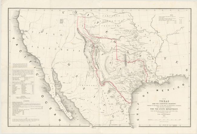
Auction 138, Lot 338
Subject: Texas, Southwestern United States
Emory, William Hemsley
Map of Texas and the Countries Adjacent: Compiled in the Bureau of the Corps of Topographical Engineers …, 1844
Size: 32.5 x 21.3 inches (82.6 x 54.1 cm)
Estimate: $6,000 - $9,000
First US Government Issued Map of the Republic of Texas
Sold for: $3,750
Closed on 12/7/2011
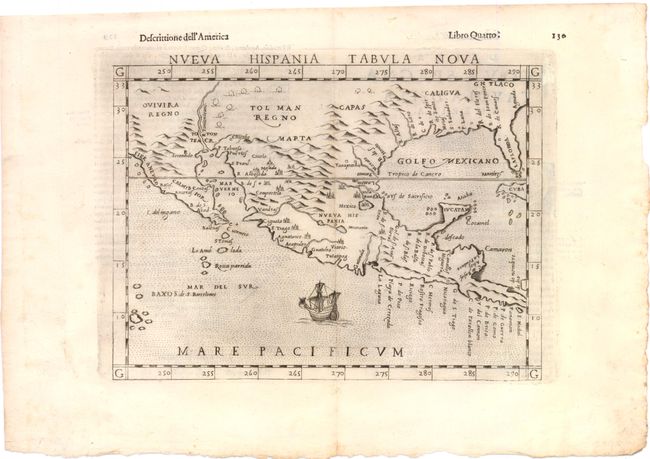
Auction 138, Lot 363
Subject: Southwest United States & Mexico
Ruscelli, Girolamo
Nueva Hispania Tabula Nova, 1598
Size: 9.8 x 7.5 inches (24.9 x 19.1 cm)
Estimate: $1,100 - $1,300
A Foundation Map for the American Southwest
Sold for: $800
Closed on 12/7/2011
27 lots