Subject: Texas, Southwestern United States
Period: 1844 (dated)
Publication:
Color: Hand Color
Size:
32.5 x 21.3 inches
82.6 x 54.1 cm
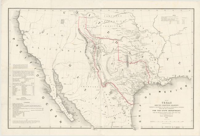
This is a very important map in the history of Texas as it is the first United States government issued map to recognize the boundaries of an independent Republic of Texas. This map, along with other treaty documents supporting the annexation of Texas, was sent by John Tyler to the Senate for approval. However, the Senate failed to ratify the treaty. Texas' annexation became a major presidential issue in 1844, when Democrat James K. Polk won easily with the slogan of "The reoccupation of Oregon and the reannexation of Texas". Due to the heightened awareness of the issue, six thousand additional copies of the map were ordered by the Senate. This is the large format edition - not to be confused with the smaller version.
The map itself is mostly a copy of the Arrowsmith map of 1841 with additional information compiled from sources listed in a table at lower left. The western and southern boundary of Texas is the Rio Grande and extends northward to just south of South Pass, which created a very elongated panhandle. The eastern boundary follows the Red River and Sabine River. Emory's ample boundaries place Sante Fe in Texas and El Paso (Passo del Norte) some 30 miles too far north; an error that would be repeated on Disturnell's "Treaty Map" of 1847. Many trails and roads are shown including Gregg's routes of 1839 and 1840, the Chihuahua Trail and the old Santa Fe Road to name a few. Several Indian relocations are shown in the region north of Texas along with the Proposed Ne-bras-ka Territory. The areas west of Texas are void of much inland detail outside of two large unnamed lakes in the Great Basin region. The Russian Establishment on Bodega Bay is noted. Ironically, Emory had never even been to Texas, but he was able to patch together information from other explorations like Fremont and Kearney to compile this remarkable map.
References: Wheat (TMW), #478; Martin & Martin, #33.
Condition: B
Nice dark impression on bright paper with a few small, faint spots. Issued on two joined sheets and folded. There are four quarter-sized holes and a 1x3" hole at center which have been expertly restored in facsimile. The map is backed with Japanese tissue to repair some minor splits, which do not distract.