Showing Featured Lots(remove filter)
Filtered by Category:United States(Show All Categories)
Showing results for:Auction 137
Catalog Archive
30 lots
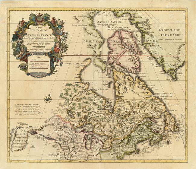
Auction 137, Lot 140
Subject: Colonial United States & Canada
Delisle/Covens & Mortier
Carte du Canada ou de la Nouvelle France et des Decouvertes qui y ont ete faites…, 1730
Size: 22.5 x 19.5 inches (57.2 x 49.5 cm)
Estimate: $1,300 - $1,600
One of the most influential maps of Canada, the Great Lakes and Upper Midwest
Unsold
Closed on 9/14/2011
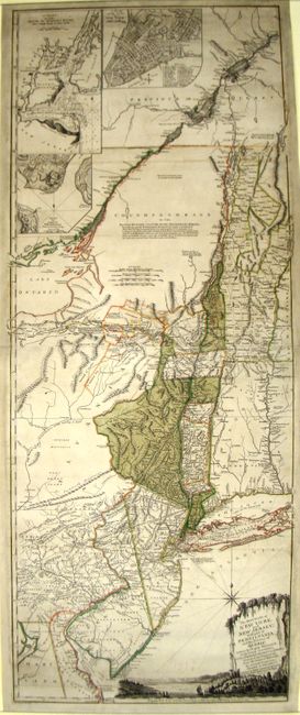
Auction 137, Lot 144
Subject: Colonial Northeast and Quebec
Holland/Pownal
The Provinces of New York, and New Jersey; with Part of Pensilvania, and the Province of Quebec. Drawn by Major Holland…, 1777
Size: 20 x 52.3 inches (50.8 x 132.8 cm)
Estimate: $4,000 - $5,000
Rare German Edition of an Important Revolutionary War Period Map
Sold for: $2,600
Closed on 9/14/2011
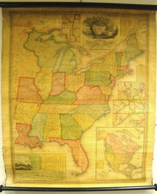
Auction 137, Lot 160
Subject: United States
Mitchell, Samuel Augustus
Map of the United States by J.H. Young, 1833
Size: 35 x 44 inches (88.9 x 111.8 cm)
Estimate: $1,400 - $1,800
Rare, Early Edition Mitchell Wall Map
Unsold
Closed on 9/14/2011
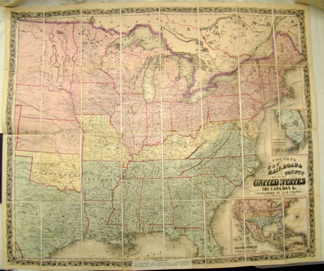
Auction 137, Lot 167
Subject: United States
Colton, Joseph Hutchins
Colton's New Railroad & County Map of the United States, 1862
Size: 39.5 x 33 inches (100.3 x 83.8 cm)
Estimate: $1,000 - $1,200
Rare Colton Civil War Map for a British Audience
Sold for: $1,200
Closed on 9/14/2011
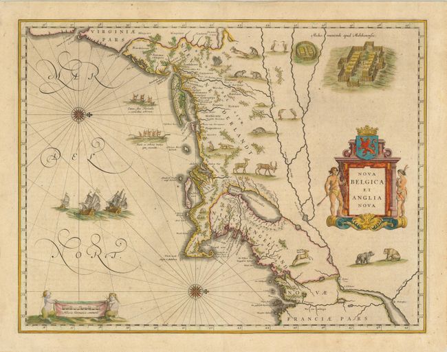
Auction 137, Lot 192
Subject: Colonial New England and Mid-Atlantic
Blaeu, Willem
Nova Belgica et Anglia Nova, 1638
Size: 20 x 15.3 inches (50.8 x 38.9 cm)
Estimate: $3,250 - $4,000
Important Map of Colonial New England and Mid Atlantic
Sold for: $3,250
Closed on 9/14/2011
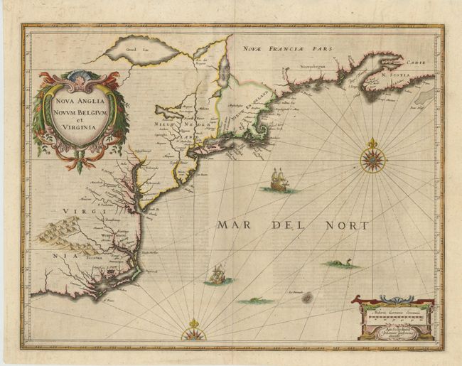
Auction 137, Lot 193
Subject: Colonial New England and Mid-Atlantic
Jansson, Jan
Nova Anglia Novum Belgium et Virginia, 1649
Size: 20 x 15.3 inches (50.8 x 38.9 cm)
Estimate: $1,900 - $2,200
Jansson's influential map of the East Coast
Sold for: $1,300
Closed on 9/14/2011
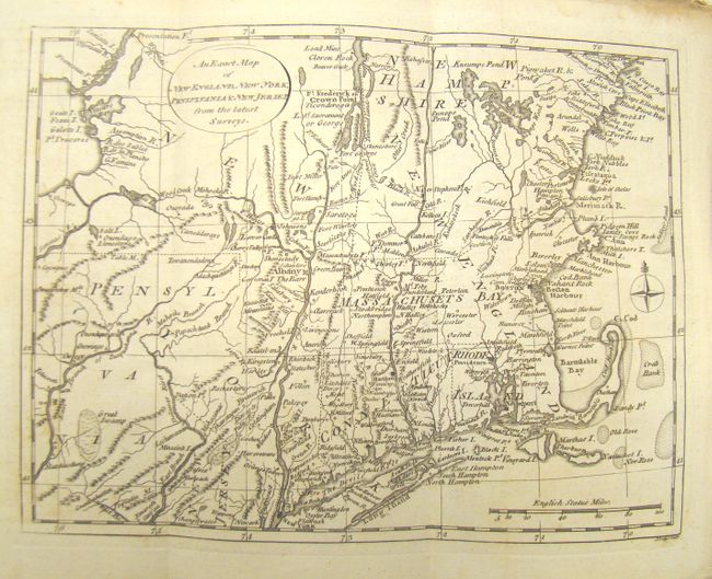
Auction 137, Lot 197
Subject: Colonial New England and Mid-Atlantic
Lodge, John
An Exact Map of New England, New York, Pennsylvania & New Jersey From the Latest Surveys, 1777
Size: 6.5 x 9.5 inches (16.5 x 24.1 cm)
Estimate: $475 - $600
Uncommon Revolutionary War Map
Sold for: $350
Closed on 9/14/2011
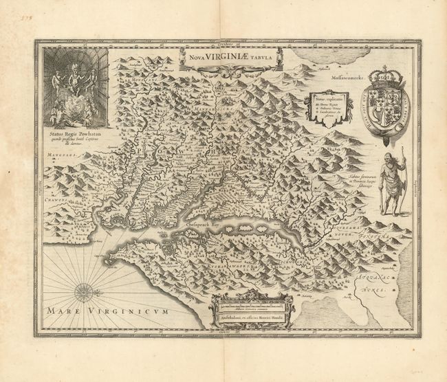
Auction 137, Lot 204
Subject: Colonial Mid-Atlantic
Hondius, Henricus
Nova Virginiae Tabula, 1630
Size: 19.5 x 15 inches (49.5 x 38.1 cm)
Estimate: $2,300 - $3,000
Unsold
Closed on 9/14/2011
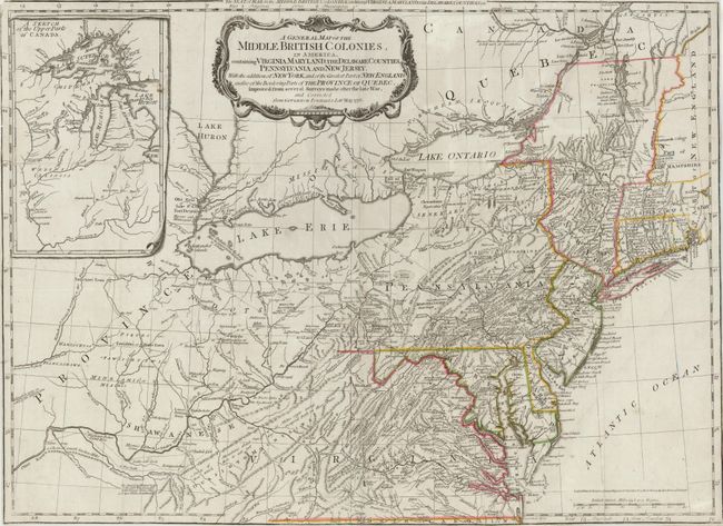
Auction 137, Lot 207
Subject: Colonial Mid-Atlantic
Sayer & Bennett
A General Map of the Middle British Colonies, in America, containing Virginia, Maryland, the Delaware Counties, Pennsylvania and New Jersey. With the Addition of New York, and of the Greatest Part of New England…, 1776
Size: 26 x 19 inches (66 x 48.3 cm)
Estimate: $2,200 - $3,000
Important Map of the Seat of War
Sold for: $2,000
Closed on 9/14/2011
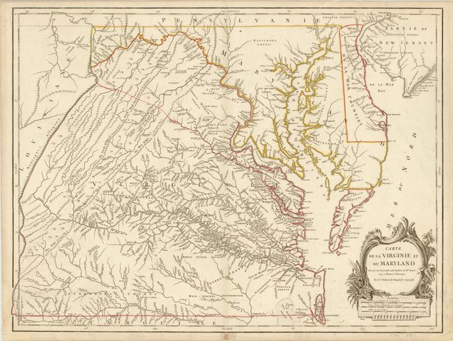
Auction 137, Lot 209
Subject: Colonial Mid-Atlantic
Robert de Vaugondy, Didier
Carte de la Virginie et du Maryland Dressee sur la Grande Carte Angloise de Mrs. Josue Fry et Pierre Jefferson…, 1793
Size: 25.5 x 19.3 inches (64.8 x 49 cm)
Estimate: $3,000 - $3,750
An Essential Map of Virginia and Maryland
Sold for: $2,200
Closed on 9/14/2011
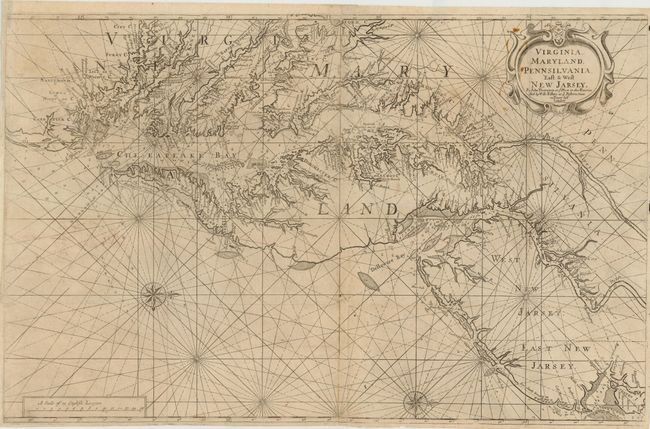
Auction 137, Lot 210
Subject: Mid-Atlantic United States
Thornton, John
Virginia, Maryland, Pennsilvania, East & West New Jarsey, 1698
Size: 31.5 x 20 inches (80 x 50.8 cm)
Estimate: $6,000 - $7,500
Scarce First Edition English Chart of the Chesapeake and Delaware Bays
Sold for: $6,500
Closed on 9/14/2011
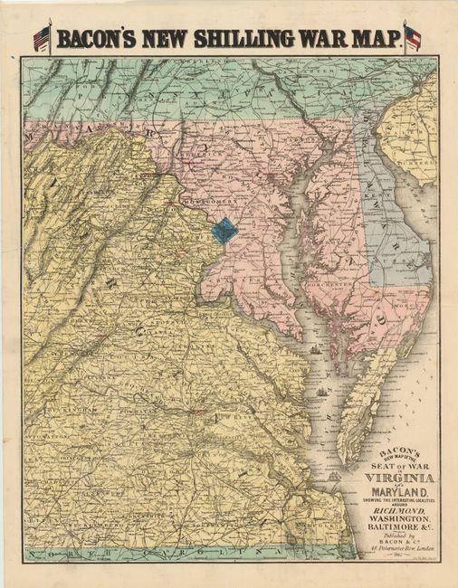
Auction 137, Lot 215
Subject: Mid-Atlantic United States
Bacon, G. W. & Company
Bacon's New Map of the Seat of War in Virginia and Maryland. Showing The Interesting Localities Around Richmond, Washington, Baltimore &c.…, 1862
Size: 18 x 22 inches (45.7 x 55.9 cm)
Estimate: $1,000 - $1,300
Rare British Civil War Map
Sold for: $950
Closed on 9/14/2011
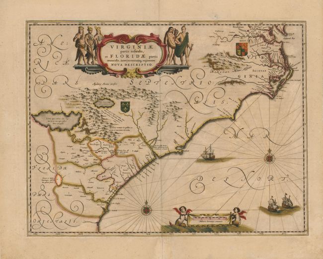
Auction 137, Lot 218
Subject: Colonial Southeast
Jansson, Jan
Virginiae Partis Australis, et Floridae Partis Orientalis, Interjacentiumq Regionum Nova Descriptio, 1645
Size: 19.8 x 15.2 inches (50.3 x 38.6 cm)
Estimate: $1,500 - $1,800
Unsold
Closed on 9/14/2011
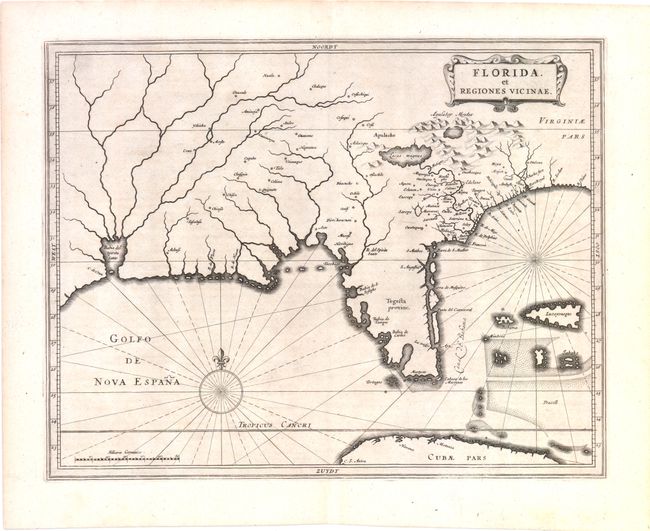
Auction 137, Lot 227
Subject: Colonial South
Gerritsz/De Laet
Florida, et Regiones Vicinae, 1630
Size: 14 x 11.3 inches (35.6 x 28.7 cm)
Estimate: $3,750 - $4,500
Unsold
Closed on 9/14/2011
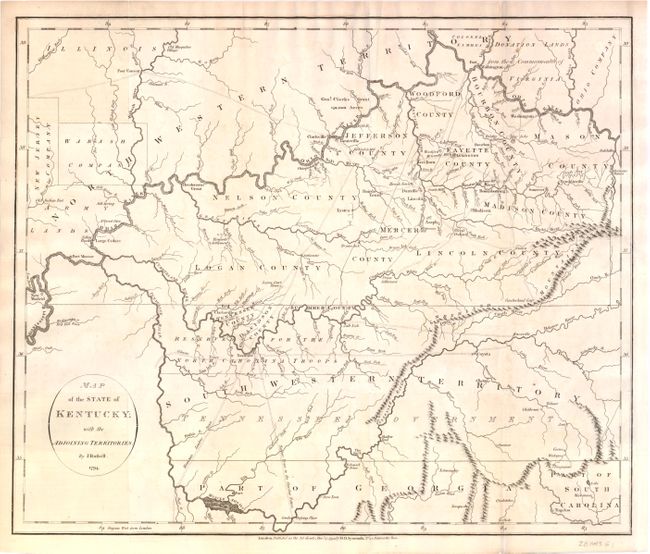
Auction 137, Lot 233
Subject: Kentucky and Tennessee
Russell, John C.
Map of the State of Kentucky; with the Adjoining Territories., 1794
Size: 17.8 x 15 inches (45.2 x 38.1 cm)
Estimate: $1,000 - $1,300
An Important Map of the Trans-Appalachian Frontier
Unsold
Closed on 9/14/2011
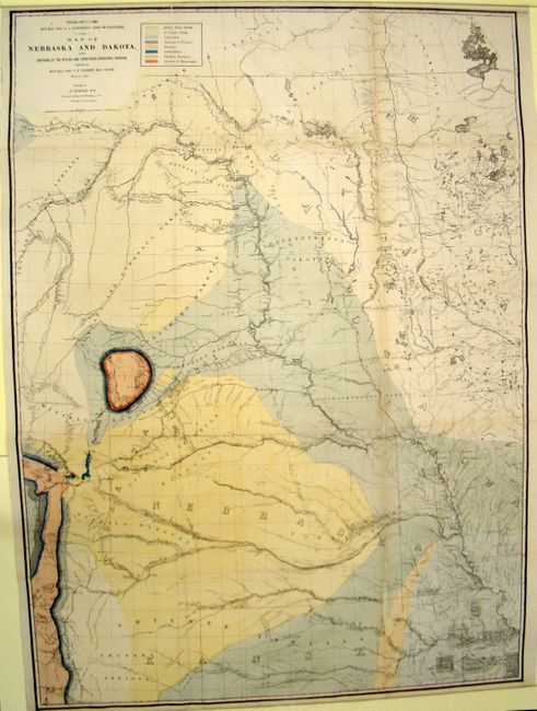
Auction 137, Lot 245
Subject: Upper Midwest United States
Warren, Lieut. G. K.
Map of Nebraska and Dakota, and Portions of the States and Territories Bordering Thereon…, 1867
Size: 31.5 x 43.5 inches (80 x 110.5 cm)
Estimate: $600 - $800
An Early Geological Map Focused on the Black Hills and Front Range
Sold for: $450
Closed on 9/14/2011
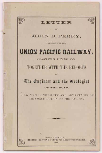
Auction 137, Lot 257
Subject: Western United States
Map of the Routes of the Union Pacific Railroads with Their Eastern Connections [with] Letter of John D. Perry, President of the Union Pacific Railway…, 1868
Size: 18 x 7 inches (45.7 x 17.8 cm)
Estimate: $400 - $500
Rare Union Pacific Railroad Pamphlet and Map
Sold for: $150
Closed on 9/14/2011
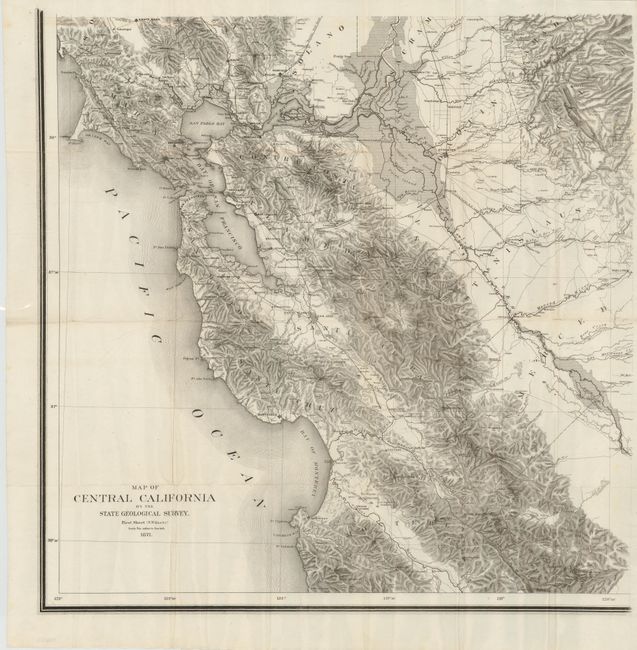
Auction 137, Lot 280
Subject: California
Map of Central California by the State Geological Survey - First Sheet (S.W. Quarter), 1871
Size: 24 x 24 inches (61 x 61 cm)
Estimate: $2,500 - $3,250
Scarce Topographical Map of California
Sold for: $1,800
Closed on 9/14/2011
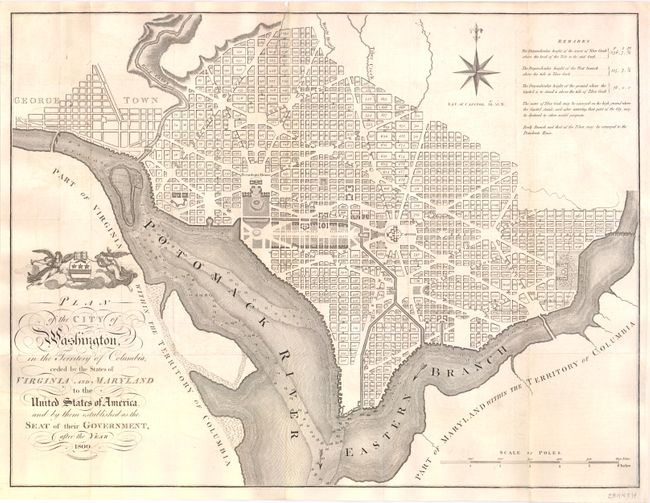
Auction 137, Lot 296
Subject: Washington, D.C.
Russell, John C.
Plan of the City of Washington, in the Territory of Columbia, Ceded by the States of Virginia and Maryland to the United States of America, and by Them Established as the Seat of Their Government, After the Year 1800, 1795
Size: 21 x 15.8 inches (53.3 x 40.1 cm)
Estimate: $3,500 - $4,500
Rare, Early Large Format Map of Washington D.C.
Sold for: $2,750
Closed on 9/14/2011
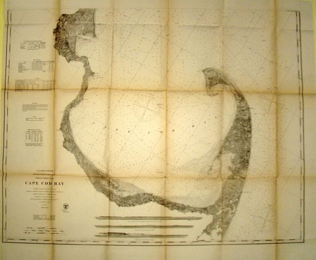
Auction 137, Lot 327
Subject: Massachusetts
U.S. Coast Survey
Coast Chart No. 10 - Cape Cod Bay Massachusetts, 1872
Size: 39 x 31.5 inches (99.1 x 80 cm)
Estimate: $300 - $400
Sold for: $220
Closed on 9/14/2011
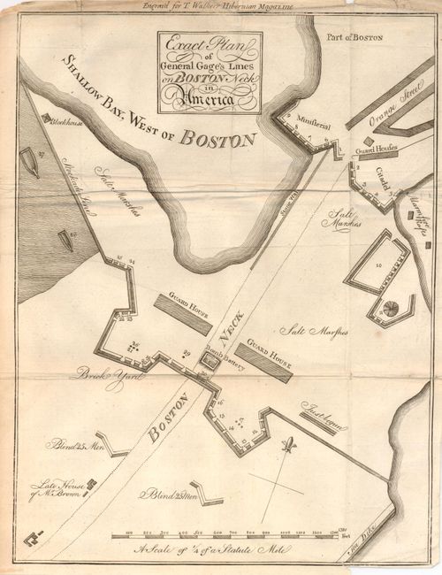
Auction 137, Lot 332
Subject: Boston, Massachusetts
Anon.
Exact Plan of General Gage's Lines on Boston Neck in America, 1775
Size: 8.7 x 11.5 inches (22.1 x 29.2 cm)
Estimate: $800 - $1,200
Early Plan of Boston at the Beginning of the American Revolution
Unsold
Closed on 9/14/2011
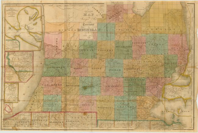
Auction 137, Lot 337
Subject: Michigan
Farmer, John
An Improved Edition of a Map of the Surveyed Part of the Territory of Michigan, 1836
Size: 31 x 21 inches (78.7 x 53.3 cm)
Estimate: $1,600 - $1,900
Sold for: $1,500
Closed on 9/14/2011
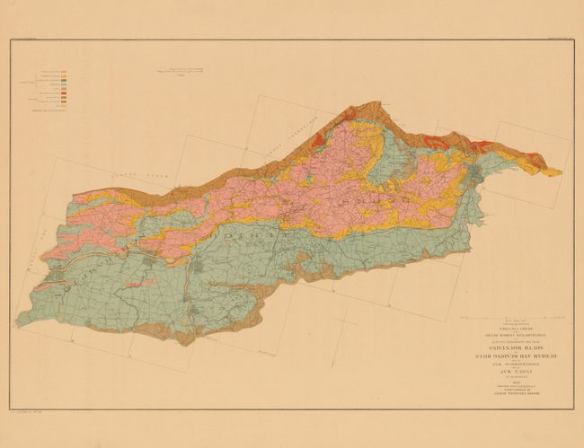
Auction 137, Lot 368
Subject: Pennsylvania
[Lot of 6] Second Geological Survey of Pennsylvania. Grand Atlas Division I, II, III, IV, V [and] VI, 1885
Size: 27 x 32 inches (68.6 x 81.3 cm)
Estimate: $2,000 - $3,000
Complete Set of the 2nd Geological Survey of Pennsylvania
Sold for: $1,000
Closed on 9/14/2011
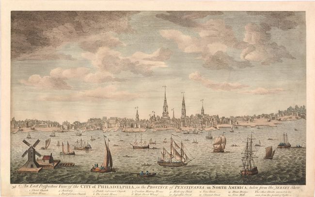
Auction 137, Lot 370
Subject: Philadelphia, Pennsylvania
Bowles, Carrington
An East Perspective View of the City of Philadelphia, in the Province of Pensylvania, in North America; Taken From the Jersey Shore., 1794
Size: 16.3 x 9.5 inches (41.4 x 24.1 cm)
Estimate: $5,000 - $8,000
A Rare, Early View of Philadelphia
Sold for: $3,500
Closed on 9/14/2011
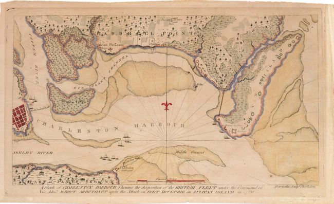
Auction 137, Lot 379
Subject: Charleston, South Carolina
Ramsay, David
A Sketch of Charleston Harbour Shewing the Disposition of the British Fleet under the Command of Vice Adm. Mariot Arbuthnot upon the Attack on Fort Moultrie on Sulivan Island in 1780, 1785
Size: 11.8 x 6.5 inches (30 x 16.5 cm)
Estimate: $1,400 - $1,700
Scarce Map of Charleston and the Battle at Fort Sullivan
Unsold
Closed on 9/14/2011
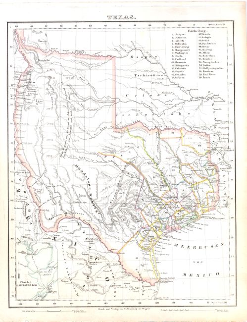
Auction 137, Lot 380
Subject: Texas
Flemming, Carl
Texas, 1845
Size: 12.5 x 16 inches (31.8 x 40.6 cm)
Estimate: $1,000 - $1,400
Scarce German Map Showing the Republic of Texas
Sold for: $950
Closed on 9/14/2011
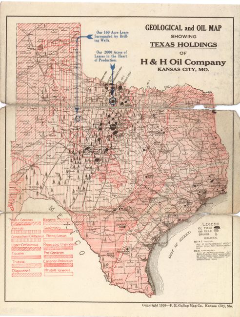
Auction 137, Lot 385
Subject: Texas
[Lot of 2] Geological and Oil Map Showing Texas Holdings of H&H Oil Company [and] Plat Showing The Refinery, Pipe Lines and Production of the H&H Oil Company, 1920
Size: 8 x 10 inches (20.3 x 25.4 cm)
Estimate: $400 - $600
Unique Texas Oil Map
Sold for: $250
Closed on 9/14/2011
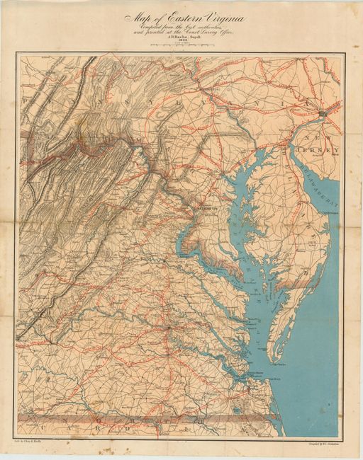
Auction 137, Lot 394
Subject: Virginia
Nicholson, W. L.
Map of Eastern Virginia Compiled From the Best Authorities and Printed at the Coast Survey Office, 1862
Size: 19 x 24.5 inches (48.3 x 62.2 cm)
Estimate: $900 - $1,100
Important Virginia Civil War Map
Unsold
Closed on 9/14/2011
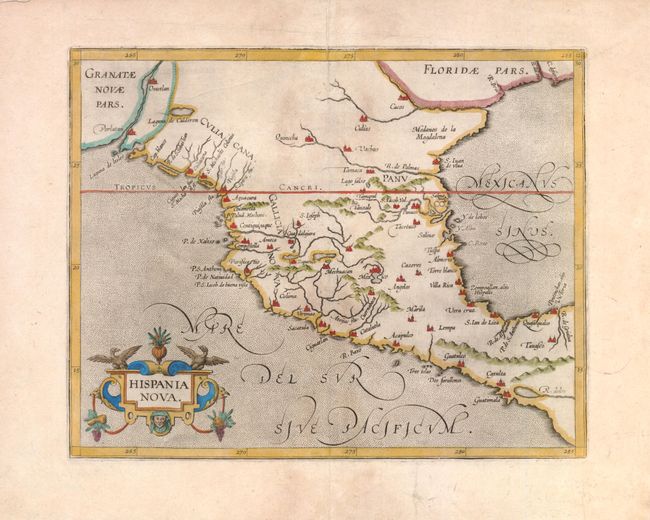
Auction 137, Lot 401
Subject: Southwest United States and Mexico
Wytfliet, Cornelis
Hispania Nova, 1597
Size: 11.4 x 9 inches (29 x 22.9 cm)
Estimate: $950 - $1,100
Early Map of the American Southwest and Mexico
Sold for: $650
Closed on 9/14/2011
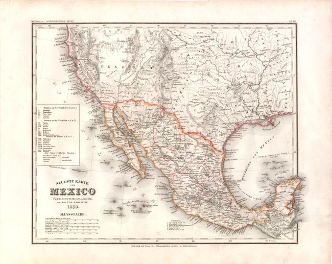
Auction 137, Lot 409
Subject: United States, Mexico & Utah
Meyer, Joseph
Neueste Karte von Mexico…, 1850
Size: 14.5 x 11.8 inches (36.8 x 30 cm)
Estimate: $300 - $400
Rare Map Showing Deseret
Sold for: $600
Closed on 9/14/2011
30 lots