Subject: Mid-Atlantic United States
Period: 1698 (circa)
Publication: The English Pilot
Color: Black & White
Size:
31.5 x 20 inches
80 x 50.8 cm
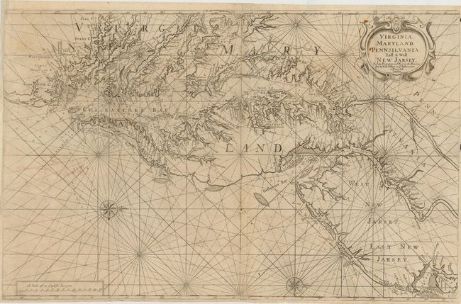
This scarce first edition navigational chart of the Chesapeake and Delaware Bays was the primary chart used by merchant vessels in these waters in the late 17th and early 18th centuries. It was originally issued by John Thornton and William Fisher in 1689 for inclusion in The English Pilot, The Fourth Book, which is considered the first great English sea atlas. The map was subsequently revised over the course of the next 100 years with reissues by Grierson in 1730 and Mount & Page in 1742. Thornton based his map on Augustine Herrman's 1673 map of the region. This two-sheet map is joined, as issued, and stretches from the Outer Banks to Staten Island. Oriented with west at top, it features two compass roses and a decorative cartouche, and highlights navigational information in the waters, such as water depths, shoals, and sandbars.
References: Stephenson & McKee, p. 40.
Condition: B+
Watermarked paper with a few very small holes at fold intersections have been professionally repaired on verso. Also some small stains near title cartouche and a few minute holes visible only when held up to light.