Subject: Colonial Mid-Atlantic
Period: 1776 (dated)
Publication: American Military Pocket Atlas
Color: Hand Color
Size:
26 x 19 inches
66 x 48.3 cm
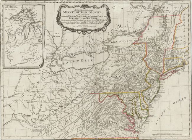
This is a later derivative of the seminal Lewis Evans map of the Middle British Colonies, which was one of the landmarks of American cartography. It has been updated to illustrate the Seat of War at the outbreak of the American Revolution from Governor Pownall's map of the same year. The map covers the region from Montreal and the lower end of Lake Huron to the North Carolina border, and from the Falls of the Ohio to Narragansett Bay, with an inset Sketch of the Upper Parts of Canada (Illinois Country). This map was an invaluable resource during the war and is filled with incredibly detailed information including provincial boundaries, courthouses, roads, trails, Indian villages and territories, forts, swamps, mines, portages, and distances between towns. Sayer and Bennett's imprint and the date, 15th Oct. 1776, just above the distance scale.
References: McCorkle #776.10; Sellers & Van Ee #714; Steven & Tree #30-f.
Condition: B
Old color with a few separations at fold intersections. A few fold separations have been professionally closed on verso, with the exception of a 1" separation near the center of map. Trimmed close to neatline on all sides, and minute loss of neatline in upper-left corner. A few faint pencil marks that do not distract.