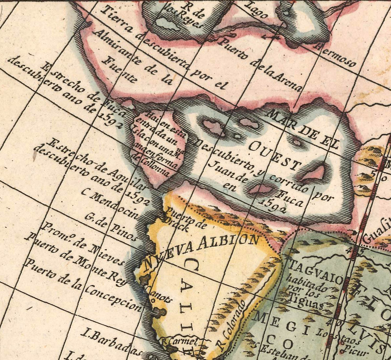
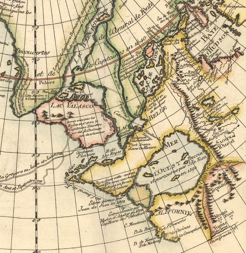
Through the Strait of Juan de Fuca into the Sea of the West, from Pedro Gendron’s La America Dispuesta Segun las Ultimas… (ca. 1756)
The Man Behind The Last Great Cartographic Myth: An Interview with Don McGuirk on the Sea of the West
by Joe McAlhany
Guillaume Delisle (1675-1726) may have ushered in a new era of scientific precision among French cartographers, but the great geographer was also inadvertently and indirectly responsible for one of the great cartographic myths of the 18th century: the Mer de l’Ouest (or the Sea of the West). This vast inland sea in the Pacific Northwest appeared on more than 200 printed maps from 1700 until 1810, the majority of them from French cartographers.Delisle had depicted the sea on some of his early manuscript maps but never included it on a published map; it would have violated his sense of scientific integrity to print a map with such a large, unverified geographical feature. Fellow Parisian cartographer Jean-Baptist Nolin did not share the same compunction—he plagiarized Delisle’s manuscripts and published the first printed map to feature the Sea of the West in 1700.
The Sea of the West only appeared on a small scattering of maps over the next five decades, until it was revived in 1750 by Delisle’s heirs, Philippe Buache (Guillaume’s son-in-law) and Joseph Nicolas Delisle (Guillaume’s half-brother). Their new representation of the Mer de l’Ouest, based on an apocryphal account of the voyage of Admiral de Fonte, brought controversy—and a slew of new maps featuring the spurious sea in a variety of formations. It was only after the Pacific Coast expeditions of Captains James Cook and George Vancouver in the late 18th century that the Sea of the West began to fade from maps.
We wanted to learn more about the history of this fascinating cartographic myth, so we reached out to Don McGuirk, the man behind The Last Great Cartographic Myth: Mer de l’Ouest, an authoritative online resource dedicated to the Sea of the West. At its center is a comprehensive cartobibliography describing 239 maps that show the Sea of the West. It also features an invaluable introduction that summarizes the history of the mapping of the Sea of the West and an English translation of Joseph Nicolas Delisle’s memoir, Nouvelles Cartes des Découvertes de l'Amiral de Fonte: et Autres Navigateurs (1753) (translated with the assistance of Jim Walker). The memoir includes Delisle’s translation of the Admiral de Fonte letter and commentary on his new outline of the Mer de l’Ouest. If you are even the least bit curious about the Sea of the West, McGuirk’s website is essential. But be forewarned—it’s easy to get lost searching for the Sea of the West.
OWA: Before we get into the Sea of the West, can you tell us a little about your background? How did you become interested in antique maps?
DM: I am a retired pediatrician. My first “antique maps” were purchased at age 10. On the back page of a comic book, there was an ad stating one could purchase three “antique maps” for two dollars! They were rather poor reproductions. I believe that one of these was an Ortelius world map. The next purchase was about 25 years later. I had recently moved to Denver. There was a small ad about an antique map store on Colfax run by Paul Mahoney on the bottom page of a Denver Medical Society publication. The spark was relit.
OWA: For those who may not have heard of it, what was the Sea of the West?
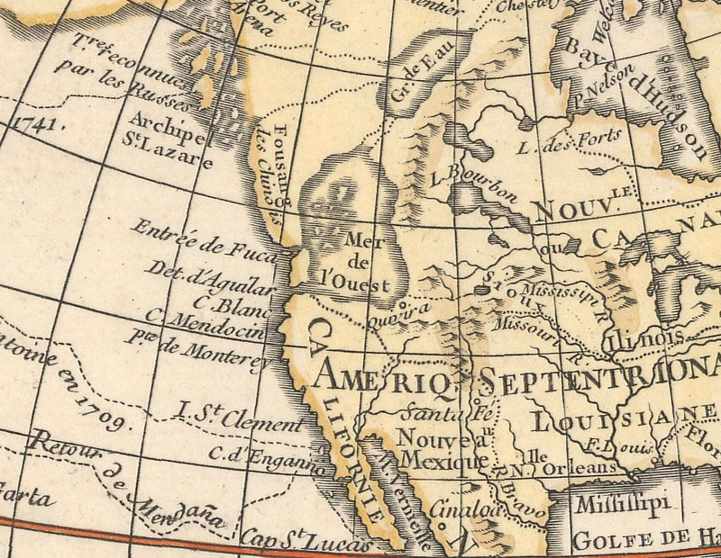
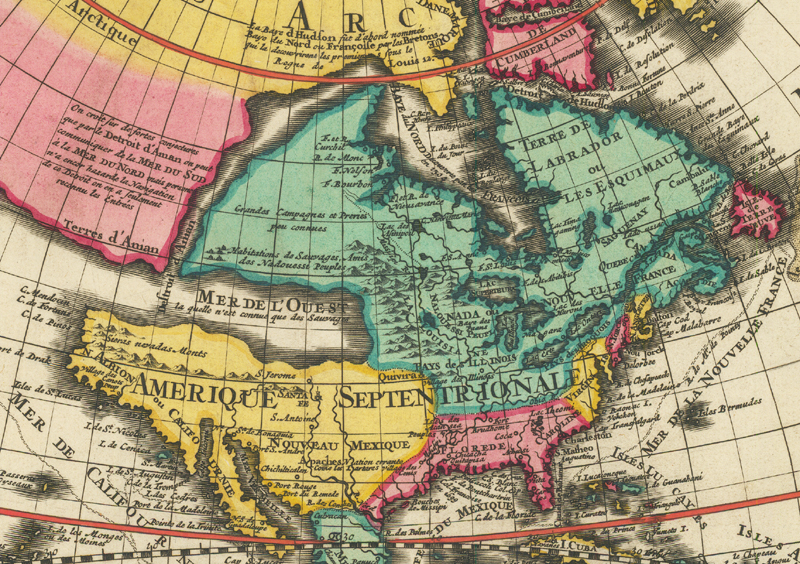
DM: The Sea of the West (or Mer de l’Ouest) was the Mediterranean Sea-sized cartographic myth appearing in the area of the present-day states of Washington, Oregon, Idaho, and Montana. This myth was first postulated by French cartographers, appearing on many printed maps from 1700 to as late as 1810.
As if the Mediterranean were in the Pacific Northwest, from Nolin’s Mappe Monde Carte Universelle de la Terre Dressee sur les Relations les Plus Nouvelles… (1755)
OWA: What ignited your interest in the Sea of the West?
DM: I became interested in cartographic myths about 1990. I was fascinated by how some of the brightest minds of their times could be so wrong in their presentations. What information had they used to come to these very incorrect conclusions? It soon became clear that the most misunderstood of these myths was the Mer de l’Ouest.
OWA: Can you remember the first time you noticed it on a map?
DM: If memory serves, the first map was Carte des Nouvelles Découvertes au Nord de la Mer du Sud (dated 1750, published ca. 1752) by Philippe Buache and Joseph Nicolas Delisle.
First siting: detail of the Mer de l’Ouest from Buache and J. N. Delisle’s Carte des Nouvelles Découvertes au Nord de la Mer du Sud (1752)
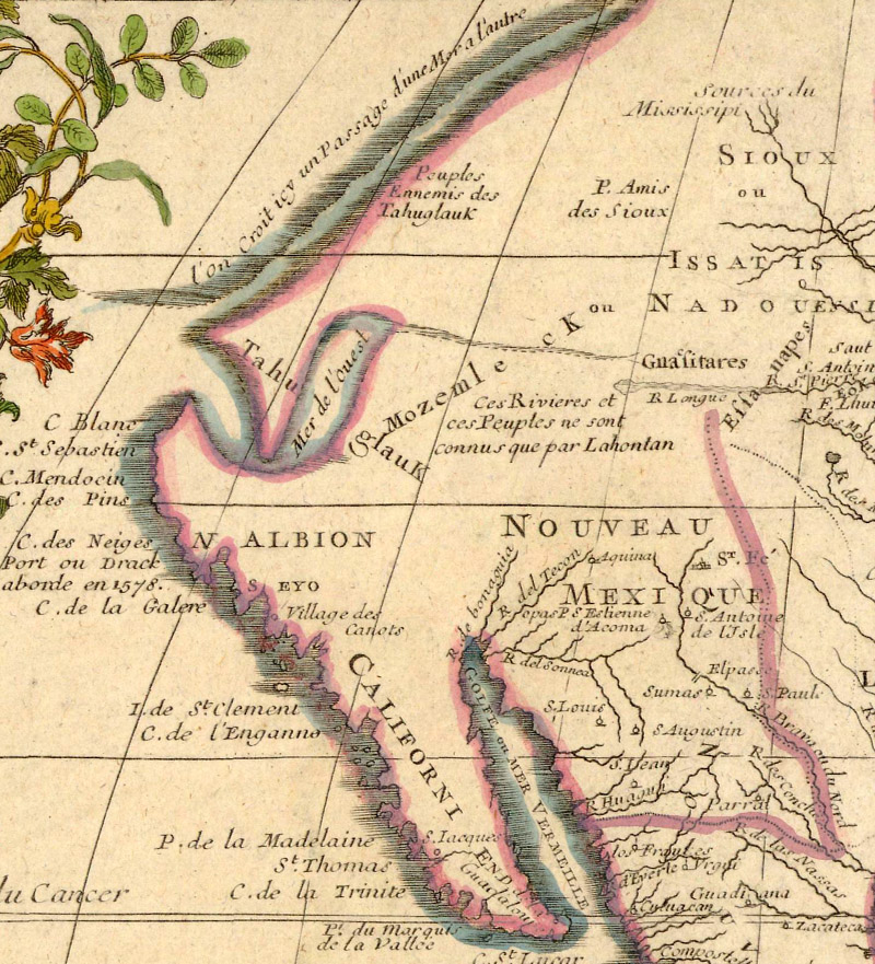
OWA: On your website, you mention early North American cartographic myths like the Sea of Verrazzano and the “branch of the South Sea” on the Yale manuscript map. How are these cartographic misconceptions related to the Sea of the West?
DM: My sense is that these are three different cartographic myths all based on the same hopeful thought that just over the horizon there is a vast sea that will make it easier to get to Asia and its treasures.
OWA: You trace the Mer de l’Ouest myth back to manuscript maps by Guillaume Delisle, but note that he never included it on a printed map. Why did he omit it from his printed work?
DM: Guillaume’s maps were known for their accuracy. His manuscript maps noted the Mer de l’Ouest was “not yet discovered” but “known to the natives.” Guillaume did produce small manuscript handbooks, including small manuscript maps, and a globe, and gave them to aristocrats in the hope that it would spur on further western discoveries in French Canada. An often-unknown fact is that one of the objectives of the Canadian explorer Pierre Gaultier de Varennes, sieur de La Vérendrye was to discover this Mer de l’Ouest.
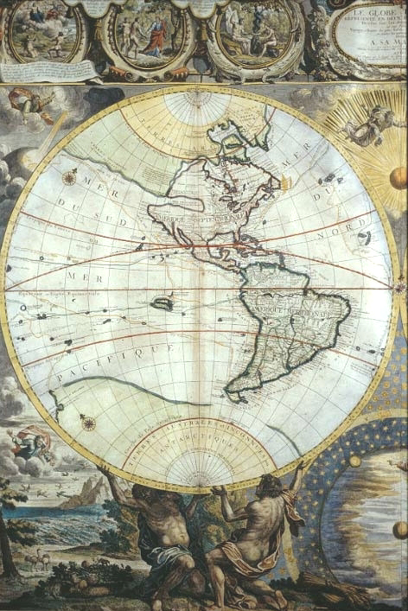
The Mer de l’Ouest makes its debut on a printed map, from Nolin’s Le Globe Terrestre Representé en Deux Plans-Hemispheres (1700)
OWA: What was the first printed map to depict the Mer de l’Ouest?
DM: The Mer de l’Ouest first appeared on a printed map in the year 1700. A contemporary of Guillaume Delisle named Jean Baptiste Nolin produced a very large and detailed map of the world, Le Globe Terrestre Representé en Deux Plans-Hemispheres. This map included a Mer de l’Ouest similar to those of Delisle. Apparently, Nolin had obtained one of Delisle’s manuscript globes and transferred its geography onto his wall map. This indiscretion did not go unnoticed by Delisle and led to a charge of plagiarism. Seven years later, Nolin was forced to turn over his plates to Delisle, allowing him to remove the “offending geography,” and Delisle was also allowed to destroy any of Nolin’s wall maps that he found.
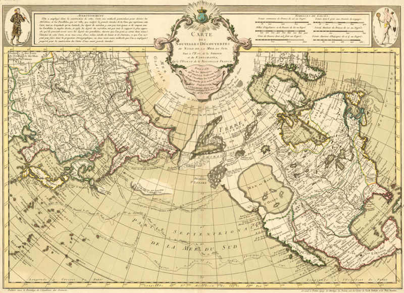
The map that resurrected the Mer de l’Ouest myth: Buache and J.N. Delisle’s controversial printed map of 1752
OWA: You said the J. N. Delisle/Buache map was likely the first time you saw the Mer de l’Ouest on a map. Their map is one of the key maps of the Sea of the West. What role did J. N. Delisle and Buache play in popularizing the myth?
DM: These two played a significant role in this endeavor. Before their manuscript map was presented to the Royal Academy of Sciences on April 8, 1750, and then published in 1752, only 15 maps and their varied states showed a Mer de l’Ouest. The myth was dying. They literally resurrected this myth and hundreds of maps with a Mer de l’Ouest followed.
When their map was first printed in 1752, there was an immediate uproar. People took sides. Some of the cartographers started to show the Sea of the West in various forms, while others said this is just hogwash and just ignored it. Some cartographers, like Kitchin, sort of played it both ways. They would have a landmass with Sea of the West written across it. So that was a good cheat.
But the geography on the Delisle/Buache map did not match the information they said it was based on, which was from the Admiral de Fonte myth. Their large Sea of the West extended too far to the north. They both recognized this and came to two different solutions.
For his part, J. N. Delisle resolved the issue in his map, Carte Génerale des Découvertes de l’Amiral de Fonte et Autres Navigateurs Espanols Anglois et Russes, pour la Recherche du Passage a l Mer du Sud (1753). This map significantly decreases the size of the Mer de l’Ouest. Of interest, this map can be placed over the map that he and Buache created to correct the errors. An example of this being done can be found in the British Library. This recreation has been incorrectly identified in the past as a variant of the original map.
J. N. Delisle’s corrected Mer de l’Ouest, as seen on Didier Robert de Vaugondy’s copy of Carte Génerale des Découvertes de l’Amiral de Fonte… (1772)
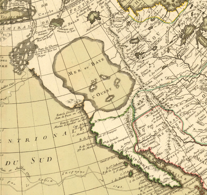
Another key map of the Sea of the West is Buache’s final correction of the original map. Buache struggled with his first attempts, leaving the northern shore of his Mer de l’Ouest undefined. He finally resolved the problem with several maps in 1755, including his map Mappemonde á l'Usage du Roy, which he attributed to his father-in-law, Guillaume Delisle. Many of the cartographers that followed chose one of these two formats for their own Mer de l’Ouest.
Buache’s revised sea, from his Mappemonde a l'Usage du Roy par Guillaume Delisle… (1755)
OWA: Can you give us a brief rundown on some of the most common configurations/models of the Sea of the West?
DM: There are basically five: 1. Guillaume Delisle’s large and long Mer de l’Ouest (1695). 2. The much smaller Mer de l’Ouest that Nolin used in his revised 1707 wall map. (Curiously, the Mer de l’Ouest there looks suspiciously like the westernmost coast on Guillaume Delisle’s 1708 Carte du Canada). 3. The large Mer de l’Ouest by Buache and J. N. Delisle (1750, first printed 1752). 4. J. N. Delisle’s Sea of 1753. 5. Buache’s 1755 Sea.
There are three others, but they appeared on only a few maps. Some cartographers just made up stuff (but didn’t they all?), presenting the Mer de l’Ouest in a pennant and pentagonal shape.
Nolin’s smaller Mer de l’Ouest, from his L'Amerique ou le Nouveau Continent Dressee sur les Memoires les Plus Nouveaux… (1720)
OWA: You have compiled an excellent digital reference on the Sea of the West that gets a lot of use here at OWA. What was the process of putting together The Last Cartographic Myth?
DM: The idea of a digital reference came from a conversation with Glen McLaughlin. He published a marvelous book on another cartographic myth, California as an island. I asked him what might have made his book better. He quickly replied, “If I could have presented larger images of the maps.”
In a printed format, that would be impossible. However, Jeremy Pool in Cambridge, MA (MapRecord Publications) had developed a computer program to digitalize the previously printed Antique Map Price Record. In conversation with him, he agreed that it would be possible to publish a cartobibliography using his software. He spent many hours refining it to meet this purpose.
The work was published in 2011 and has been “out of print” for many years. A fellow Mer de l’Ouest collector, Daniel “daan” Strebe, recently contacted me regarding obtaining a copy of the thumb drive the book was loaded onto. As I only had 2 personal copies available, I was hesitant. He proposed modifying the program so that it could be loaded onto the internet. With the help of Jeremy and daan’s son, Musashi, the book is now available to everyone at: https://sea-of-the-west.info/title
If someone asked me what I could have done better, it would have been to have a professional photographer to take the pictures. However, the cost would have been prohibitive considering the potential sales of the book. My wife, Di, and I did the best we could!
OWA: Could you tell us a little about the translation of the J. N. Delisle memoir that is an appendix on your site?
DM: I would recommend that people take a look at the Delisle memoir [Nouvelles Cartes des Découvertes de l'Amiral de Fonte: et Autres Navigateurs]. If you read through that, you really get an idea of the information that J. N. Delisle was dealing with and why he felt that this might all fit together with the Sea of the West, the Northwest Passage, and some additional geography.
OWA: What made you choose to call it The Last Great Cartographic Myth? It’s quite a striking title.
DM: It’s funny because one of the early book reviews said, “Well, there will be plenty more cartographic myths. Why did he choose that?” So this gives me a chance to answer that.
The reason I called it The Last Great Cartographic Myth was because of its size. It’s a huge sea—if you were to measure it out it would be larger than the Mediterranean Sea. California as an island is a great cartographic myth, and huge as far as landmass goes, but it preceded the Sea of the West. And if you look at maps of 1750 and beyond, you’ll see some mythical lakes and mountain ranges here and there, but you will never find a cartographical myth as large as the Mer de l’Ouest.
McGuirk’s favorite map, Mortier’s Mappe-Monde Geo-Hydrographique, ou Description Generale du Globe Terrestre et Aquatique en Deux Plans Hemispheres (ca. 1700) [Image courtesy of Barry Lawrence Ruderman Antique Maps Inc.]
OWA: Are there any personal favorites or curiosities from your cartobibliography that you would like to single out?
DM: My favorite map is the Pierre Mortier map, Mappe-Monde Geo-Hydrographique, ou Description Generale du Globe Terrestre et Aquatique en Deux Plans Hemispheres (ca. 1700; Shirley, Mapping of the World #621, plate 426), the earliest obtainable map showing a Mer de l’Ouest. Not only is it a beautiful map, with another cartographic myth (a speculative east coast of Australia), but the whole back story of how the scattered information that the Delisles received from French Canada culminated in the imagined cartography of the Mer de l'Ouest is fascinating.
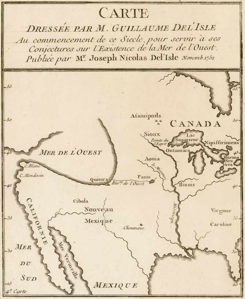
A favorite curiosity, which copied Guillaume Delisle’s manuscript maps: J. N. Delisle’s Carte Dressée par M. Guillaume Del'Isle au Commencement de ce Siecle, pour Servir à ses Conjectures sur l'Existence de la Mer de l'Ouest (c. 1753) [Image courtesy of Barry Lawrence Ruderman Antique Maps Inc.]
DM: Then there are two curiosity maps. A standard statement is that Guillaume Delisle never showed the Mer de l'Ouest on his printed maps. However, his half-brother, J. N. Delisle, did so in spades.
In 1753, J. N. Delisle published 2 maps that copied Guillaume Delisle manuscript maps. The first, Carte d’une Partie de l’Amerique Tirée des Manuscripts de M. Guill. Del'Isle ou l'on voit son Systeme en 1695…, copied a 1695 manuscript map showing a very early rendition of a Mer de l’Ouest. The second, Carte Dressée par M. Guillaume Del'Isle au Commencement de ce Siecle, pour Servir à ses Conjectures sur l'Existence de la Mer de l'Ouest, is a copy of a much later depiction of a Mer de l’Ouest (c. 1753), found in a memoir written by Guillaume.
We would like to thank Don for taking the time to share his expertise with us. There is no better guide through the tangled history of the Sea of the West. For those who would like to learn more about this fascinating cartographic myth, we highly recommend visiting The Last Great Cartographic Myth: Mer de l’Ouest. It is clearly a passion project, the end product of countless hours of hard work and diligent scholarship—and it is accessible to all for free, a generous gift to map enthusiasts, collectors, scholars, or whoever else happens to be curious about the huge imaginary body of water in the Pacific Northwest. Our upcoming September auction (September 1st - 15th) features over a dozen items that show the Sea of the West, including maps of the world, Western Hemisphere, North America, the North Pacific, and a small atlas. The catalog will go online on September 1st, and you can search “Sea of the West” or “Mer de l’Ouest” in the Search box—we always call out the Sea of the West when we spot it on a map.