A New View on the First Lithographed Map in the United States
by Jim Kissko
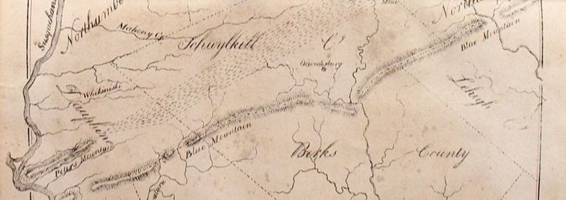
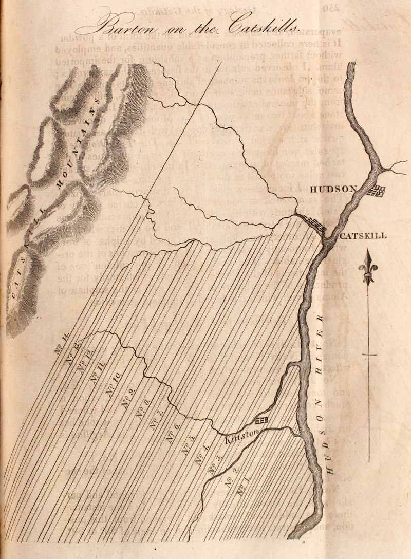
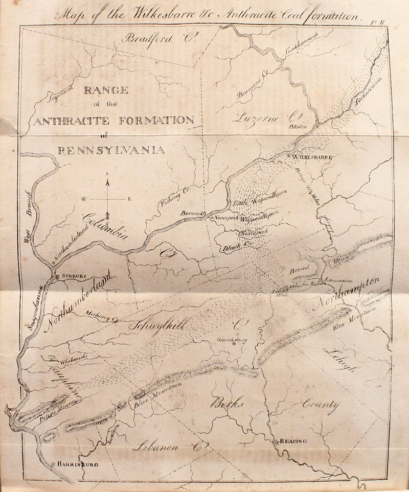
Conventional wisdom is that the first map lithographed and published in the United States is a small plan entitled “Barton on the Catskills” as noted in Ristow’s American Maps and Mapmakers (p.282) . It appeared in 1822 in Volume IV, Number 2 of Benjamin Silliman’s The American Journal of Science, and Arts. A review of a copy of Number 1 of the same volume has surfaced an earlier lithographed map, published in 1821, which apparently has escaped recognition until now. The new candidate is entitled Map of the Wilkesbarre &C Anthracite Coal Formation and shows the region from Harrisburg (Pennsylvania) north to Bradford County and east beyond Wilkes-Barre and Reading. It is larger and more detailed than the Catskills map.
Barton on the Catskills, previously recognized as the first lithographed map in the U.S. (Map measures 5.0 x 6.3")
After discovering the Wilkes-Barre map in Number 1, the key questions were whether the map was indeed a lithograph and whether it could be established clearly as preceding publication of the Catskills map. A review of the text of both issues of Volume IV provides strong support that the Wilkes-Barre map is a lithograph and that it was published toward the end of 1821 at least three months prior to the 1822 publication of the Catskills map.
Wilkesbarre &C Anthracite Coal Formation, the folding lithographic map that precedes the Barton map in Volume IV. (Map measures 8.0 x 9.6")
Evidence that the map is a lithograph. Prior researchers have referenced Editor Silliman’s article “Notice of the Lithographic Art,” which announces that: “All the drawings in the present number are printed on stone by Mssrs. Barnet & Doolittle, whom we are happy to introduce to our readers as artists in this comparatively new department.” This article begins on page 169 of Volume IV, Number 1, the same issue in which the Wilkes-Barre map appears. In Number 1 there are only three illustrations, with the Wilkes-Barre map designated as “Pl II.” The printer is not noted on the plates of Number 1, but Silliman’s statement that Barnet & Doolittle produced "all the drawings" in that issue on stone would appear to lend credence to the view that the Wilkes-Barre map was produced by Barnet & Doolittle and is indeed a lithograph.
The Catskills map appears as the first plate of Number 2. While it does not have a plate number or printer identified on the map itself, the next plate is identified as “Pl V” and does have the notation “From the lithgc press of B & D.” The Catskills map is logically the fourth plate of Volume IV. Interestingly, not all the plates in Number 2 are lithographs. This reinforces the view that Silliman’s claim in Number 1 that all the drawings “in the present number” are lithographs applies only to Number 1 of Volume IV.
Evidence that the Wilkes-Barre map was published first. While it was possible that Silliman published both issues of the volume at the same time, a practice not uncommon at the time, evidence from the text is sufficiently clear that Number 1 was published in 1821 with the Wilkes-Barre map and Number 2 was published separately in February, 1822.
The Wilkes-Barre map is referred to in the article on coal mines in Number 1. There is no editor’s footnote or other indication of its absence or delay in its publication. Given Silliman’s proud declaration that all the drawings (just three) in Number 1 were by the new process, it is unlikely he would have gone to press without one of the key features of the issue.
In addition, with the publication of Number 2, which completed Volume IV, a title page was provided for the volume dated 1822, and a preface dated February 15, 1822 contained the editor’s reflections on the publication’s past and future. Silliman noted that while the goal was to publish an issue quarterly, on average each volume had taken about seven months, and each number was published, “once in half that time.” From this we can infer that Number 1 was published around November 1, 1821. Support for this date is drawn from the text, which shows the latest dated communication of October 23, 1821. The latest dated communication in Number 2 is December 22, 1821. It is clear the two issues of Volume IV were published separately, with the 1821 Number 1 containing the Wilkes-Barre map preceding the 1822 Number 2 with the Catskills plan by approximately 3.5 months.
How did this map go unnoticed for so long? An explanation for the past oversight of the Wilkes-Barre map is given by Mott, who explained that Silliman’s Journal was struggling for survival at the time and its subscriber base was probably no more than 500 (p. 304). Therefore, surviving copies for review are scarce. In addition, it was not uncommon for subscribers to remove plates, one of the frustrations in dealing with early American periodicals. The copies reviewed by previous researchers simply may not have survived with all plates present. This distinct possibility is supported by a comment in Ristow’s earlier work on the development of lithography in the United States where he refers to the Barton map as ”the one map in the volume” (p. 105).
The evidence supports the Wilkes-Barre map as the first lithographed map in the United States and it is fascinating that it has been overlooked for some 200 years. Furthermore, the potential of the lithographic mapmaking process was more clearly demonstrated in the Wilkes-Barre map’s finer detail than in the more rudimentary Catskills plan. The inclusion of these maps in a well-respected journal marked the beginning of the lithographic revolution in the United States.
[Click here to view more details about Volume IV of The American Journal of Science, and Arts from Auction 182.]
Bibliography
Mott, Frank Luther, A History of American Magazines 1741-1850. NY: Appleton, 1930.
Ristow, Walter W., “Lithography and Maps, 1796-1850,” in Woodward, David. (ed.), Five Centuries of Map Printing. Chicago: University of Chicago Press, 1975.
Ristow, Walter W., American Maps and Mapmakers. Detroit: Wayne State University Press, 1985.
Wood, Charles B. III, “Prints and Scientific Illustration in America,” p. 178 in Morse, John D. (ed.), Prints in and of America to 1850. Winterthur Conference Report 1970. Charlottesville: University of Virginia Press, 1970.