Back to the Basics: 10 Things Every Map Collector Should Knowby Eliane Dotson
It's the beginning of a new year and time to start fresh and get back to the basics. Although many of you are experts who could certainly teach a master class in maps yourselves, I want to share with our newer customers some of the basics of antique maps that every collector should know. The more you know about key map terms, how maps were made, and what factors affect value, the better equipped you will be to create your own collection and take care of it for generations to come.
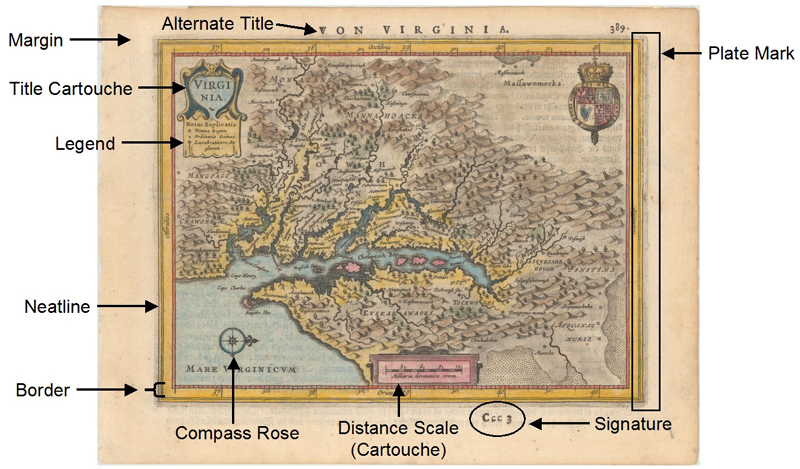
#1 - Know the Lingo There are many specialized terms used in the world of antique maps, and knowing them is the essential first step in understanding maps.
While most of these terms are self-explanatory, several deserve more explanation as they help distinguish states, editions, and reproductions, which will be discussed below. The plate mark is the impression that the engraved plate made when pressed onto paper to print the map. The plate mark can usually be felt by touch as an indentation in the paper, and there is also often some grayish ink residue along the edge of the plate mark that shows the physical size and shape of the plate. The signature is a separately printed element, usually composed of letters and/or numbers, that was added to aid the bookbinder in collating the maps into an atlas or book. Signatures can be on the recto (front) or verso (back) of the map. Maps that were bound into a folio-sized atlas were typically folded in half down the center of the map, which created a centerfold. Most folio-sized maps from the 16th-18th centuries will have a centerfold, which are still visible even if a map has been removed from an atlas and pressed flat.
#2 - Printing Methods A few decades after the invention of the printing press by Johannes Gutenberg circa 1439, printed maps began appearing on the market. (Maps that were not printed and were done by hand are called manuscript maps, and these represent a very small percentage of the maps available on the market.) Knowing the full process of how maps were printed isn't necessary; however, understanding the main characteristics related to different printing techniques is key to distinguishing reproductions from an original antique map. There were three main types of printing methods that were used over the centuries: relief, intaglio, and planographic.
With relief printing, a wood block or soft metal was used and all of the areas that were not to be printed were cut away, leaving raised lines (similar to a modern-day rubber stamp). Once the raised surfaces were inked and pressed onto paper, the printed areas would leave a slight indentation in the paper. This type of printing would not leave a plate mark and the lines it created would have an uneven distribution of ink with blunt ends.
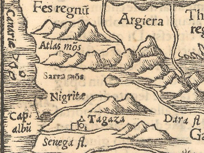
Text was often inserted using moveable type, which could be changed over time due to new information or discoveries. Relief printing is commonly called woodcut or woodblock and was the method of choice for mapmakers such as Hartmann Schedel, Martin Waldseemuller, Lorenz Fries, Sebastian Munster, and Benedetto Bordone.
The intaglio method, which includes engraving and etching, used soft metal such as copper or steel. The engraving process is somewhat opposite that of the relief method, since the image was cut into the metal and ink was rubbed into the engraved areas and cleaned off of the flat surface. When printed onto paper, the ink remained raised on the paper and the edge of the plate created a platemark.
One of the tell-tale signs of intaglio is that it produces lines that are crisp, distinct and continuous. The masters of the Golden Age of cartography all created copperplate engravings, including Ortelius, Mercator, Hondius, Blaeu, and Jansson.
The planographic method was invented in 1798 and is most commonly known as lithography. In this method, an image is drawn onto limestone or metal with a wax or grease crayon. The surface is then wetted and inked and then paper was pressed onto the inked surface. As a result both the paper and ink remain flat. This style permitted a more natural drawing style and created even finer detail, and is commonly found in 19th century atlases.
#3 - The Evolution of Paper Understanding the key attributes to papermaking and how it changed over time is also an important factor in avoiding reproductions or facsimiles. Until the late 18th century, the vast majority of maps were printed on handmade laid paper, which was made from linen and cotton rags. The paper was made on a wire screen mold that created chain lines both horizontally and vertically on the paper, which can be seen if you hold a sheet of laid paper up to light. Often shapes and names were added to the wire molds to create watermarks that identified the paper mill. Specific watermarks are attributable to certain cartographers or publishers and can help date a piece of paper and identify its source. Laid paper is characterized by long fibers that make the paper less prone to tears and by a textured and uneven surface caused by irregularities in the linen/cotton and the hand-made process.
In the 18th century the process was improved by using a much finer wire mesh mold that created a smooth surface and no chain lines (although watermarks were sometimes still incorporated) and was called wove paper. After the invention of the papermaking machine in 1807, the demand for paper increased and a less expensive method was sought. This resulted in the invention of wood pulp paper, which created a very smooth surface. However, due to the short fibers and presence of lignin in wood pulp, this type of paper had a tendency to tear and darken in color, thereby shortening the lifespan of the paper. As a result, 19th century maps are often more fragile and in poorer condition than their counterparts that are hundreds of years older. (Watermark image courtesy of Collecting Old Maps, Manasek, Griggs & Griggs.)
#4 - No Such Thing as Identical Twins If you've ever been to a map fair, then you've probably walked around the room and seen multiple examples of the same map. However more likely than not, there are differences in each of these examples, and some of these differences can cause a distinction in rarity, historical significance, and value. Although a woodblock or copperplate may have been printed hundreds or thousands of times, not every example will be the same. There are obvious differences such as imperfections in the paper, the impression (how well the ink image is transferred to the paper), the color applied to the map, or the condition of the map depending on how it was handled over time.
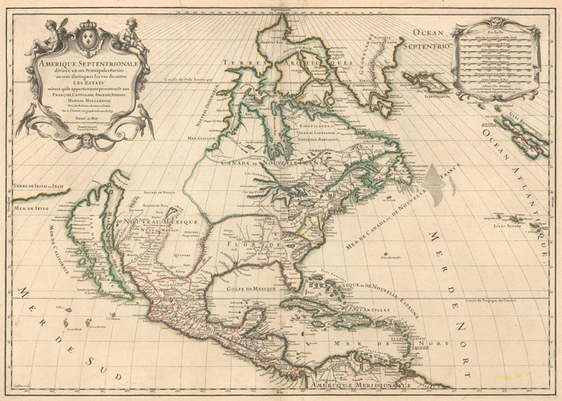
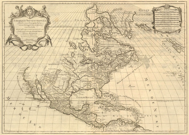
Yet there are other difference, such as the state or edition of a map, which can be more subtle. The term state is used for multiple versions of a single plate, on which changes have been made between printings. Because plates were both expensive and laborious to engrave, they were often updated with changes rather than scrapped and remade. These changes include major ones (such as new cartographic information, a re-engraved cartouche, or a new title) and minor ones (such as touch-ups to improve the image or an updated plate number). Major changes to the cartography on a plate will impact the value, although earlier states are not always the most valuable, as it depends on which state is more interesting or historically significant.
Second state of the Sanson/Jaillot map of North America, circa 1698, and showing the Island of California.
Fifth state of the Sanson/Jaillot map, published circa 1719, with the coast of California completely re-engraved.
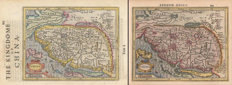
The term edition can be used in several ways. Most commonly it is used to describe a batch of impressions made from a plate and published at the same time. For instance, the maps in Ortelius' atlas, Theatrum Orbis Terrarum, appeared in many editions and can be identified by the text and page numbers that were printed on the verso of the maps. Sometimes the maps from different editions are identical, and sometimes changes were made to the plate and they represent different states. And occasionally, the plate got damaged or there were so many changes that it had to be replaced, which resulted in a new, re-engraved plate, which can be referred to as a new edition of the map. Similar to states, some editions can be more valuable than others, such as the first edition or an edition that is rarer than others.
Side-by side examples of the same map (same plate) published in two different editions - one in an English edition of Mercator's Atlas Minor and the other in a Latin edition.
#5 - Condition is King As with most collectibles, condition greatly impacts the value of a map. Flaws that are inherent to the process of papermaking, printing, and binding into book form generally do not decrease the value unless they are very distracting. These include printer's creases, binding trims, paper flaws, and minor offsetting of the ink. Defects that are confined to the blank margins and do not impact the printed image also do not impact value greatly. When considering condition, it is important to assess the severity of the flaw and the possibility that it will lead to further damage. For instance, foxing, light toning, soiling, small worm holes, fold separations, minor damp stains, and extraneous creases are very common in paper. As long as they aren't very visible and the paper is stable, they are not cause for concern.
However other issues can decrease the value of a map significantly, such as tears in the image, dark toning of the paper, heavy soiling or staining, or cracks in the paper, which can be caused by the acidity of wood pulp paper or the oxidation of some of the pigments used in the 16th-18th centuries. Fortunately most condition problems in maps can be improved or repaired by a professional paper conservator, thereby preventing further degradations and restoring the value of the map. In contrast, non-archival or poor repairs will further damage a map; it is better to leave a defect be than to make an inexperienced repair.
#6 - The Truth About Color Although most collectors prefer maps that are colored, as color can highlight the interesting geographical and decorative details, color does not always increase the desirability of a map. Some maps were not meant to be colored; in particular, maps from the late 15th through early 16th centuries were published in black ink without any color added. With these early maps, most collectors prefer that they remain in their original uncolored state. Starting in the 16th century, publishers would offer atlases sans color and made-to-order, providing affluent or important clientele with options to upgrade their copies.
Choices in color ranged from simple outline color, which means that only the borderlines were highlighted, to elaborate full color examples that only the wealthiest could afford. If color was added soon after the map was printed around the time of its publication, it is referred to as original or contemporary color. Maps that feature original color are a big draw for collectors, especially when the color is well-preserved. Later color (also called modern or recent color) was applied well after the map's publication. It's a broad term; later color could have been applied yesterday in a startling replica of the old style or hundreds of years ago in a sloppy, anachronistic hand. Because it tends to increase the value of the map, sellers will typically point out when they believe an example is in original color. If a map isn't advertised as being in original color, it is likely later color.
The only downside to original color is that is can suffer from oxidation, which refers to the chemical reaction that occurs when certain substances are exposed to oxygen. Verdegris, the green pigment used on early maps, oxidizes over many years to varying degrees. At its most mild, oxidation causes the green pigment to turn darker or slightly brown; however in severe situations the green pigment deteriorates the paper and causes brittleness and cracking. This can be most readily seen by holding the paper up to light, or by viewing the back of the map. While maps with well-preserved, original color are highly prized by collectors, they are less common on the market than their modern-colored counterparts.
#7 - Lies and White Lies Although forgeries are common in the art world, fortunately they are not a big problem for antique map collectors. However, collectors should always be on the lookout for restrikes, reproductions and forgeries. A restrike is a much later edition pulled from the original plate and will usually be printed on different paper or have some notation that it is a restrike. A reproduction is made for decorative purposes, typically on modern paper and sometimes in a larger or smaller format. Even though restrikes and reproductions were not created with the intent to deceive, they can be mistaken for the real thing. A forgery is a fake that is being passed off as real. Fortunately these aren't common in the map world and most are well documented in reference books.
There are a few key steps that anyone can use to verify that a map is authentic:
Examine the map outside of a frame. Many reproductions and restrikes will indicate that they are reprints, either in the blank margin below the map or on the back of the map, both of which are typically hidden in a frame.
Get a sense for the paper. The type of paper used should correspond with the time period when the map was printed. Holding the paper up to light can help get a sense of whether the texture and consistency are appropriate.
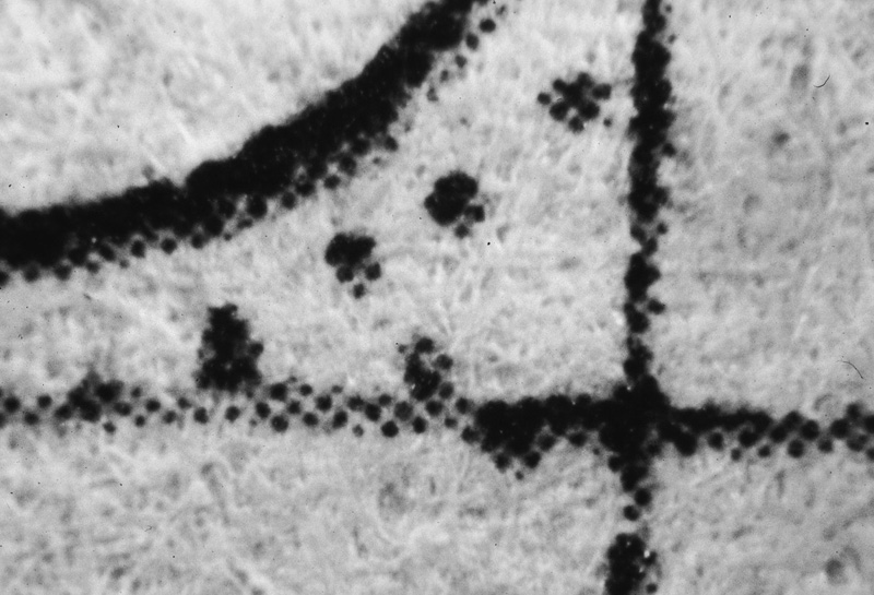
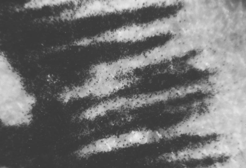
Use a magnifier. Even a 10x magnification of the map will betray a reproduction by inspecting the black ink lines. Most reproductions will have blurred lines, tiny specks of ink spattered around the lines, or the lines will be made up of tiny dots of ink.
Compare it with an original. It is not difficult to find an image of the same map on the internet, and by comparing the questionable map with a known original, you can spot differences. The two easiest features to compare are the fold lines and the plate mark; on a reproduction, these features will either be missing or will be added in a different location from the original.
Magnified examples of maps reproduced using modern printing methods. Note the lines made up of dots of ink at left, and the tiny spatters of ink surrounding the image at right. (Images courtesy of Collecting Old Maps, Manasek, Griggs & Griggs.)
#8 - How to Value a Map It's easier to figure out what to buy than to decide how much to pay. Determining what a map is worth is part science and part art. In general terms, a map is worth whatever the market indicates it is worth, so one way to get a sense for a map's value is to look at how much it has sold for in the past. Of course when comparing prices, you have to take into account the differences in condition, color, and the state of the different examples of the map, as each of these factors affects the price. Certain regions, cartographers, and collecting themes (like the Island of California) are more popular and therefore tend to sell for more. You must also take into consideration whether the comparable prices are auction results (also called hammer prices) or dealer prices, as the latter will typically be higher than auction results. Two great resources for map prices are RareBookHub.com and OldMaps.com, and values listed within the last 5-7 years are still considered relevant.
Some maps are uncommon and haven't appeared on the market in many years. For rare maps, you may not find any historical pricing, so you'll have to look at prices for similar maps. In these instances, compare maps that show the same geographical region, were published within 10 years of the map in question, and are similar in size. However, the rarer a map is, the more valuable it will likely be in relation to comparable maps. Ultimately the market will decide what these maps are worth, and if you come across a really rare piece, don't miss out. Some maps are quite common, while others are only offered on the market once every 10-20 years.
#9 - Write Your Autobiography While it may be tempting to follow the current trends in map collecting, it is not the best strategy for most collectors. A map collection should be personal. A map collection can be meaningful in many ways: it can trace your ancestry, showcase places you've traveled, or spark your intellectual curiosity about a particular time in history. There are so many different types of maps to collect that it can feel overwhelming if you take a shotgun approach.
Reference books can serve as an excellent way to narrow down your collecting area and determine what maps would be a good fit for your collection. There are books that cover geographic regions (like maps of the world, Holy Land, New England, etc.), specific collecting interests (like pictorial maps, railroad maps, Revolutionary War maps, etc.), or individual mapmakers.
Regardless of what you decide to collect, it is important to select a focal point and stick with it. Over time you can either further refine or even expand your area of interest depending on your time and budget.
#10 - Be a Map Custodian The fact that so many antique maps have survived for hundreds of years is incredible. Once you add a piece to your collection, you must take steps to preserve your historical artifact for generations to come. Maps should never be handled by the very edge of the paper, as that can cause tears; ideally you should pick up a map several inches from the edge of the paper, using both hands to provide adequate support. Paper clips, binder clips, post-it notes, and tape should never be used on antique paper, as they can damage the image or paper surface. If you must write notations on a map (preferably on the back), using a soft leaded pencil is fine.
Many collectors opt to frame their maps both to preserve and appreciate them. Maps should be framed by a professional using only acid-free, PH-neutral materials, reversible mounting adhesives, and sealed frames. Framed maps must be kept away from direct light sources and high humidity to prevent damage to the paper.
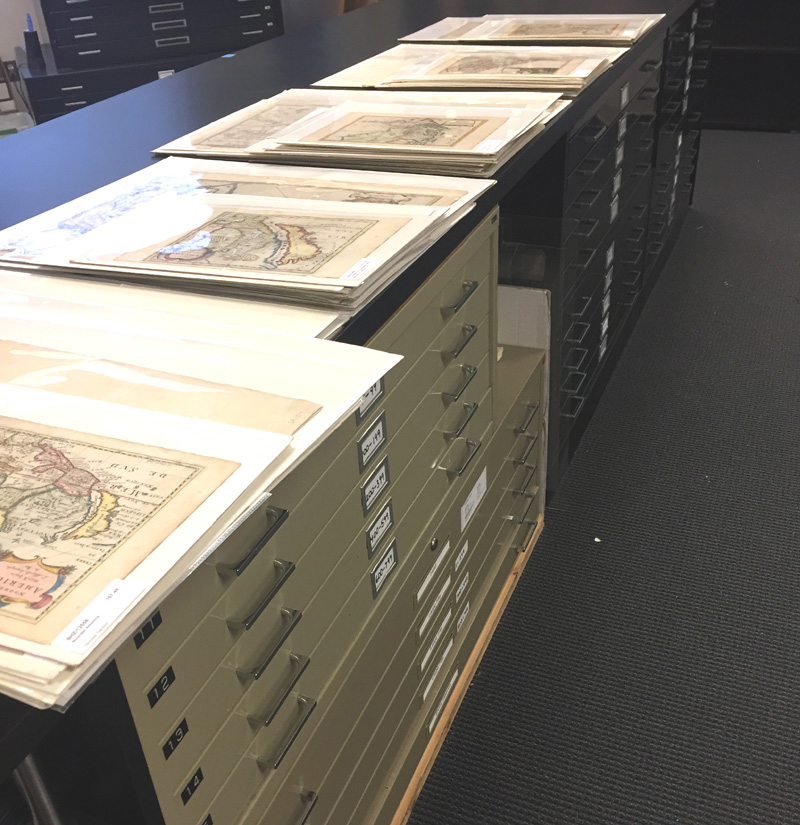
Once you've run out of wall space, there are other options for preserving maps. Companies such as Gaylord Archival and University Products sell archival sleeves and folders for storing maps, which can then be housed in a flat file, on an easel, or on any flat surface. Clear archival sleeves are an excellent choice for maps, as they protect the map from any tears or damage due to handling, while still allowing you to view both the front and back of the map.
Regardless of how you choose to store and display your maps, consider yourself a temporary custodian, whose responsibility is to ensure your collection's continued survival for the next few centuries.
Beyond the Basics Maps are prized by collectors around the globe for their beauty, historical significance, and the stories they tell. While there are many reasons that people collect maps, collectors typically have one feature in common - an intellectual curiosity powered by a thirst for knowledge. Maps teach us about history, geography, politics, religion, and culture by taking us to another place and another time. Regardless of your reason for collecting maps, having a solid foundation on the basics can help you take your collection to the next level.
Of course this article gives just a brief overview of these topics. To find more information, please review one of the many excellent reference books on collecting maps. Here are three of our favorites:
Manasek, F.J., Curt Griggs & Marti Griggs. Collecting Old Maps. Clarkdale, Arizona: Old Maps Press, 2015.
Moreland, Carl & David Bannister. Antique Maps. Oxford: Phaidon Christie's, 1986.
Potter, Jonathan. Collecting Antique Maps. London: Studio Editions Limited, 1992.