With our auctions officially concluded for 2017, we wanted to share a brief overview of some of the highlights for the year. We believe that providing transparency to performance is not only useful as a guide to buying and selling for 2018, but also helps to establish openness and trust with our customers.
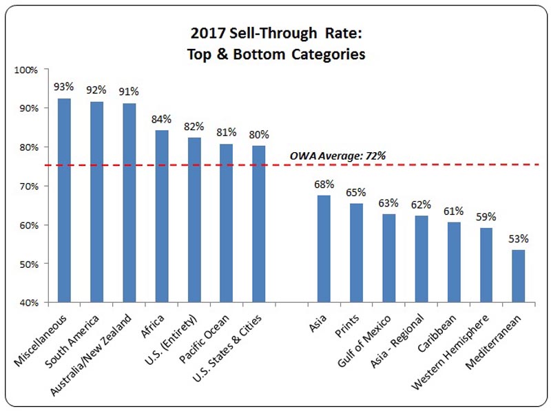
In a nutshell, while the political climate in the world appears to be increasingly volatile, our take on the microcosm of antique map collecting appears to be stable and relatively similar to 2016. Old World Auctions overall sell-through rate, which is defined as the number of items that sell as a percentage of the total number of items in the auction, was 72%. This is about 3% lower than last year, but above the industry average of 69% for antique maps, books, and ephemera categories as reported by Rare Book Hub (based on over 270,000 listings for 2017 through early December).
Our Customers
What sells best in our auctions is largely driven by where our bidders reside. For the year, 70% of bidders came from the United States, 5% from Canada, 3% each from the United Kingdom and Australia, and 2% each from Italy and the Netherlands. In total we had bidders from 50 different countries including Brunei, Croatia, Iceland, Jamaica, Kazakhstan, Malta, New Zealand, Panama, Saudi Arabia, South Africa, and Ukraine to name a few. We love getting the opportunity to work with people as diverse as our antique map offerings!
Trends by Geography
Since most of our customers are from the United States, it follows that two of our top performing categories in 2017 were maps of the entire US and maps of US states and cities. Also strong performers were maps of the continents of South America, Africa, and Australia. Our miscellaneous category, which consists of cartographic curiosities, puzzle maps, and game maps, has become very popular over the years and was the top performer in 2017. Other regions did not fare as well, including maps of the Mediterranean, Western Hemisphere, and Caribbean.
Some of the geographies that sold well in 2017 have been consistently strong over the last three years, both in terms of sell-through rates and high realized prices. These include maps of the entire United States, maps of individual US states and cities, atlases, reference books, and our miscellaneous category. Several map regions were not top performers in 2017 but have been on an upward trend over the last few years, such as those of the continents of South America, Europe and Africa, as well as maps of Central America, largely driven by maps of Panama. Some regions have exhibited consistently poor performance since 2015, including the Mediterranean, Gulf of Mexico, Western Hemisphere, Canada, and the Caribbean. Other categories used to have excellent sales results but have been on a downward trajectory in the last couple of years. Manuscripts and Incunabula used to be a very strong category for OWA, but have faltered in the last two years. Maps of Canada were solid performers 4-5 years ago, but have recently seen a decline.
Top Selling Items
We also reviewed our top individual performing lots, and not surprisingly, regional maps of the Americas comprise the majority of this list:
Auction 162 - Lot 308. Map of Texas and Parts of Adjoining Territories, by U.S Geological Survey, 1899. Sold for $950 -- 380% above the high estimate
Auction 165 - Lot 226. Topographical Map of the District of Columbia Showing the Projected Harbor Improvement…, by A. Boschke, 1880. Sold for $850 -- 370% above the high estimate
Auction 164 - Lot 369. To James Vernon Esqr...This Plate Representing the Taking of Porto Bello..., by William Henry Toms, 1740. Sold for $3500 -- 350% above the high estimate
Auction 162 - Lot 340. [A Map of the British Empire in America (Sheet 18) - Central America], by Henry Popple, 1733. Sold for $2000 -- 333% above the high estimate
Auction 165 - Lot 737. [Untitled - The First Sighting of the Pacific Ocean], by Theodore de Bry, 1631. Sold for $750 -- 326% above the high estimate
Auction 161 - Lot 342. West Point New York, by U.S. Coast and Geodetic Survey, 1883. Sold for $1000 -- 267% above the high estimate
Auction 164 - Lot 216. A Diagram of a Portion of Oregon Territory, by U.S. Government, 1852. Sold for $800 -- 267% above the high estimate
Auction 165 - Lot 205. [Lot of 4 Irrigation Rights Maps - Kern County, CA], by U.S. Government, 1877. Sold for $650 -- 260% above the high estimate
Auction 163 - Lot 387. [Sheets 5 and 6] Map of the Territory of the United States, West of the Mississippi River…, by U.S. Army, 1879. Sold for $2500 -- 250% above the high estimate
Auction 164 - Lot 128. Map of the United States, by Effingham Wilson, 1833. Sold for $550 -- 239% above the high estimate
Looking Forward
We are living in strange times with a very unsettled political world coupled with financial markets reaching all time highs. However, based upon several years of consistent performance, we believe antique map collecting will continue to be stable for 2018. Due in part to our favorable sell-through rates, consignment requests continue to exceed our allotted space. This means that we can be more selective in the material we offer at auctions, with the end results being better quality, more interesting pieces in our catalogs. Similar to 2017, we are scheduling five auctions for next year in February, March, May, September and November. Our auction calendar is now posted on the website with exact dates.
We would like to thank all of you for supporting Old World Auctions over the years. We are fortunate to get to work with wonderful people and to spend most of our days pouring over old maps. We wish you all a Happy New Year and great things for 2018!
Cities Around the World: The Plans and Views of Braun & Hogenbergby Joe McAlhany
We can never walk the streets of the London or Moscow or Amsterdam that existed 450 years ago, but we do have the next best thing: the ornate and evocative city plans of Georg Braun and Frans Hogenberg. What makes their plans so special is their ability to capture not just the broad layout of a city, but its essence. They go beyond the specific details of geography, landscape, and architecture to give us a taste of each city's unique economy, culture, and soul. Braun and Hogenberg gave the world a true gift with their Civitates Orbis Terrarum: an intimate impression of hundreds of cities that have since been transformed by time.
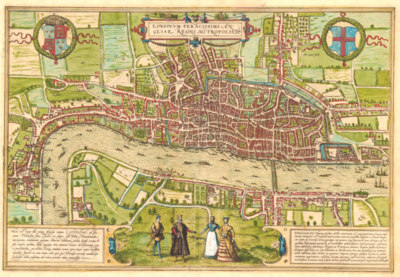
Londinum Feracissimi Angliae Regni Metropolis, the first plan in Braun and Hogenberg's Civitates Orbis Terrarium.
The Civitates Orbis Terrarum was the first truly modern city atlas. It spans six volumes and consists of 363 plates featuring plans and views of more than 450 towns and cities, along with some heraldic plates and one map (covering Denmark). Volume I was published in 1572; the sixth and final volume was published in 1617. Each volume was published in Latin, German, and French editions. John Goss, an authority on antique maps, atlases, and travel books, describes the Civitates as "a celebration of the European city" and "one of the great books of the world." Four centuries after the series' completion, its city plans and views continue to fascinate collectors, scholars, urbanists, architects, and history buffs.
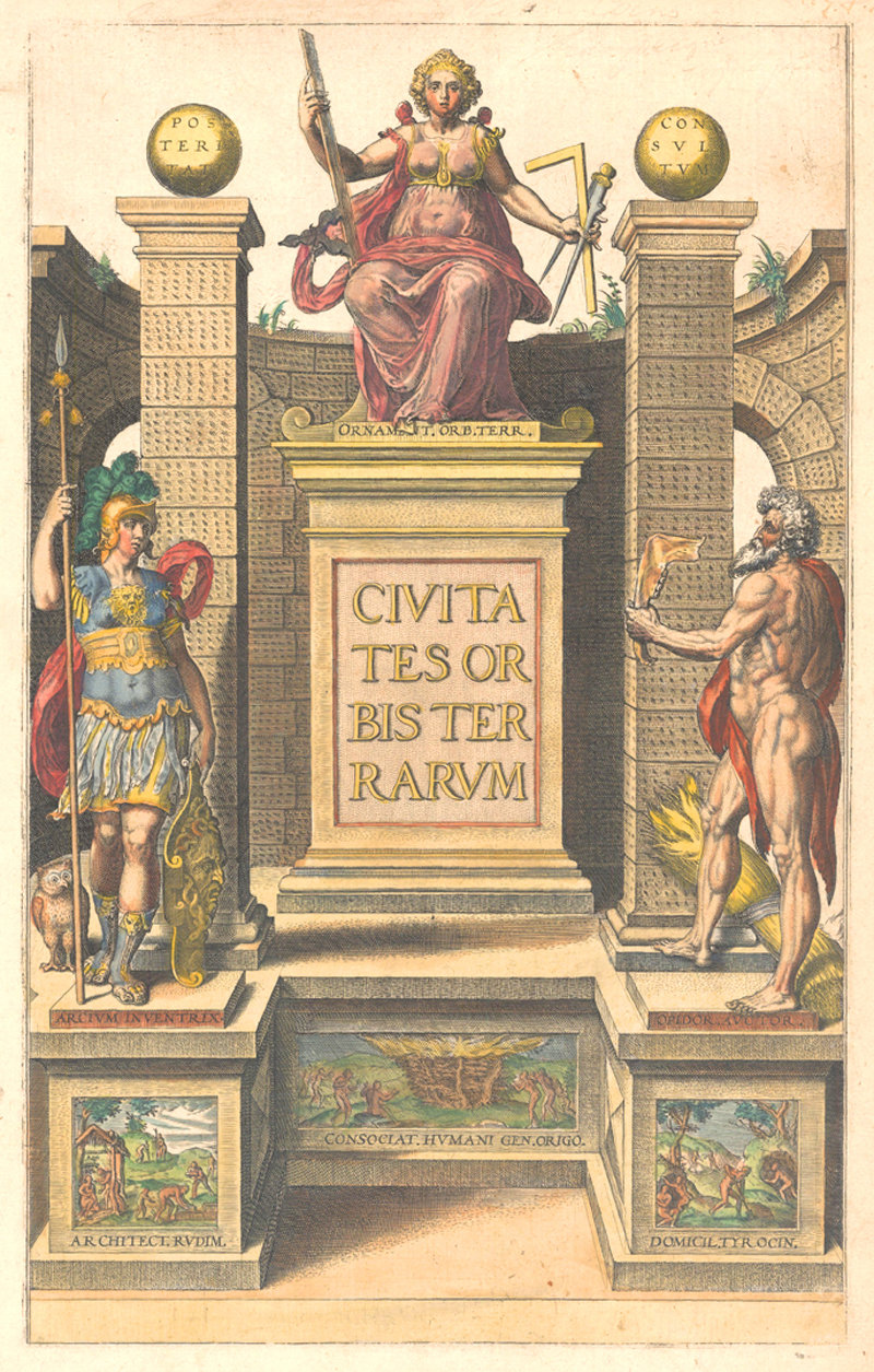
Decorative title page from Volume I of a Latin edition.
Advances in printmaking, etching, and copperplate engraving techniques at the end of the 16th century set the stage for the Civitates, while a growing mastery of perspective and geometry made its stunning bird's-eye views possible. There were city plans before the Civitates, but they were often either large-scale, separately-issued pieces intended to decorate the estates of the wealthy and powerful, or so inaccurate as to border on the fantastical. Hartmann Schedel's Nuremberg Chronicle (published in 1493) and Sebastian Münster's Cosmographia (1544) were both massively ambitious works containing many small-format woodcut city plans, but neither had the range, accuracy, or focus of the Civitates. The Nuremberg Chronicle, for instance, included numerous cities printed from the exact same block, while the Cosmographia only featured 74 city plans across its 1,200 pages -- and more than a third of those were just focused on Germany.
Braun and Hogenberg kept the focus almost exclusively on cities and in over six volumes were able to include just about every major town and city on the European radar. Their copperplate views and plans were a different breed from Schedel and Münster's woodcuts. Although towns and cities were depicted from a variety of angles, Braun preferred oblique bird's-eye views, stating that "towns should be drawn in such a manner that the viewer may look into all the roads, and streets and see also the buildings and open spaces." Centuries before Google Maps, Braun and Hogenberg attempted to provide both a comprehensive view and a street-level experience.
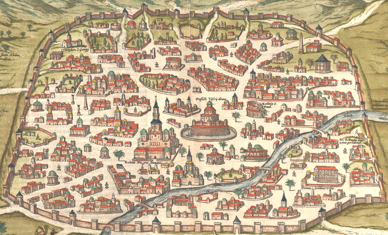
The fortifications, mosques, ruins and gardens of Damascus, from Damascus, Urbs Nobilissima ad Libanum Montem, Totius Syriae Metropolis.
They were also skilled at documenting the economy and culture of these towns and cities. One does not have to read Braun's commentaries to get a feel for the industry and social structures of the towns; one only has to look at the plan itself. Fishing towns and bustling port cities are shown in glorious detail. Given the importance of waterways to the trade of the era, Braun and Hogenberg were rigorous about their depictions of rivers and the vessels that traversed them. On land, the streets often teem with people from various walks of life: peasants, laborers, merchants, aristocrats. There are often figures in the foreground showcasing the customary local fashions. These diligent recordings of local dress earned the Civitates the reputation as one of the greatest costume books of all time.
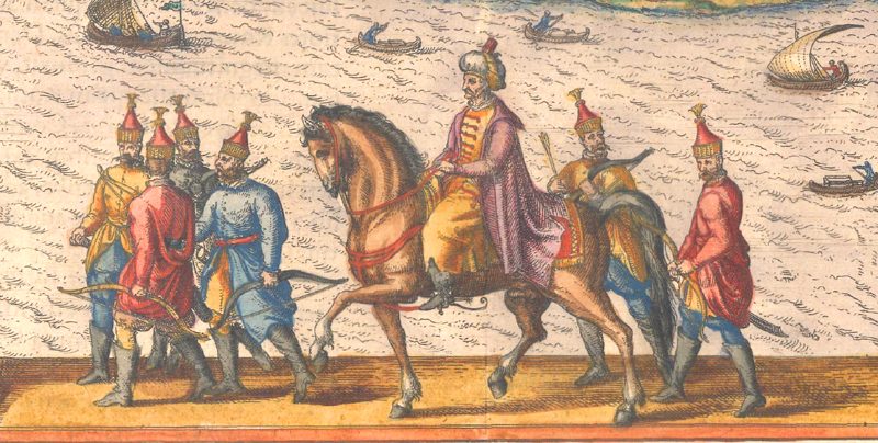
Turks from the foreground of Braun and Hogenberg's beautiful plan of Constantinople, Byzantium, nunc Constantinopolis.
But Braun's aim with these costumed figures had a more strategic dimension as well. He was paranoid about "blood-thirsty Turks" plundering his work for military secrets during their campaigns in southeastern Europe and believed, mostly erroneously, that their Muslim faith prevented them from looking upon drawings of fellow human beings. Although it can be hard to tell from many of the peaceful, idyllic views, the Civitates was published during a time of violence and conflict. Although Hogenberg concurrently engraved horrific war scenes for the Geschichtsblätter, the chaos and gore of the Eighty Years' War is largely absent from the city atlas (although Braun's anger over the conflicts kicked up by the Reformation and Counter-Reformation did gradually seep into his commentaries).
So how did the expansive, epochal Civitates come together, and who were the men behind it? Initially, the series may have been the idea of etcher and engraver Frans Hogenberg, but it was chief editor Georg Braun who took on the Herculean task of shaping the work. The Civitates was a colossal collaboration, drawing on hundreds of sources, both classical and contemporary. Braun established correspondences with map-makers, artists, town officials, and even his own readers. As Braun wrote in the preface to the 1576 German edition of Volume II, "Should anyone not find their home town or native city in either of these first two books, however, I would kindly invite them to draw it from life and send it to me." He compiled information from all of these connections to assemble the best city atlas possible.
Born in Cologne in 1541, Braun was likely the son of a glass-maker. In 1558, he started his education with the Jesuits. Although he eventually left the Order, he completed his studies in theology and became an assistant priest in 1565. That same year, he started work as a private tutor to the son of Heinrich Suderman, a politician and merchant with a large and useful network of social contacts. The first two volumes of the Civitates, published in 1572 and 1575, came together under Suderman's roof, with help from his many contacts.
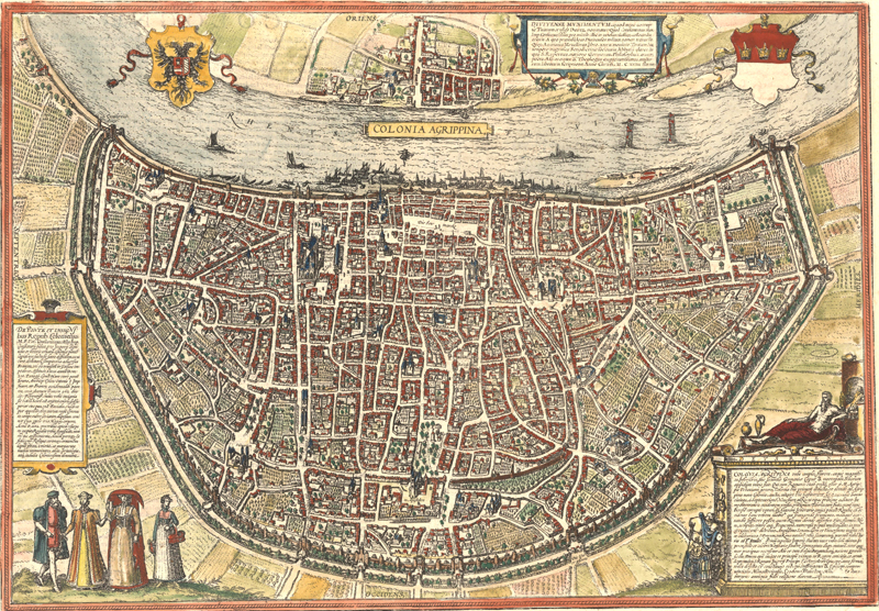
Colonia Agrippina, showing the birthplace of Braun (and the Civitates).
Braun lived with the Sudermans until 1577, when he was fortunate enough to be given a canonry at the collegiate college of St. George, which afforded him the time to throw himself into his work on the subsequent volumes of the atlas. By the time he was appointed dean of the church of St. Maria ad Gradus in 1585, his dedication to editing the Civitates was becoming something of a problem. In the preface to Volume IV, published in 1588, he confesses that he had been accused of neglecting his priestly duties for his secular interests. But he continued in his role as editor, encouraged by the influx of submissions from his growing network of collaborators, at least until the ultimate volume, published in 1617, which does not include his name. He died in 1622.
Braun's principle partner on the project, the esteemed engraver Frans Hogenberg, was born in Mechelen in 1535. His father Niklaus was an engraver who died just four years after the birth of his son. But Hogenberg and his older brother Remigius still learned their father's trade under the tutelage of their stepfather, the cartographer Hendrik Terbruggen. He worked for Mercator, engraving his large world map of 1569, and Ortelius, contributing engravings to his Theatrum Orbis Terrarum. When he relocated to Cologne to flee persecution for his Protestant faith, he revolutionized the city's printing and publishing industry by essentially bringing copperplate engraving to town. Hogenberg's work on the Civitates and Geschichtsblätter made him a success. Although he died in Keulen in 1590, before the completion of the Civitates, his son Abraham followed in his footsteps, contributing engravings to the final two volumes and publishing Volume VI along with Antonius Hierat.
Although the Civitates is credited to Braun and Hogenberg, its six volumes are in actuality the product of countless contributors, among them Heinrich von Rantzau, Danish governor of the Duchies of Schleswig and Holstein, who supplied maps, plans, and descriptions, primarily of Denmark; Simon van den Neuvel, an engraver who worked on Volumes II and III; and Jacob van Deventer, who was behind 48 of the plan views in Volumes III and IV. Abraham Ortelius's Theatrum Orbis Terrarum, the first modern atlas, originally printed in 1570, was a source of inspiration for the work; the Civitates is in many ways a companion to Ortelius's atlas, and the two are often found together, bound as a set. But Ortelius wasn't just an inspiration: he was peers with both Braun and Hogenberg and corresponded with and advised Braun throughout the process of assembling the city atlas. He is even credited with submitting preliminary drawings in the preface to the first German edition!
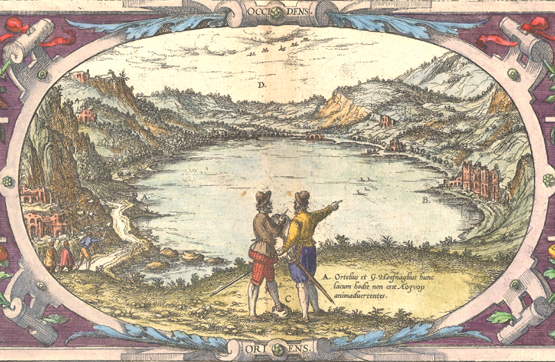
Hoefnagel and Ortelius discussing the ancient context to the name of Lake Averno from an untitled view of the Grotto of the Cumaean Sibyl.
Perhaps the most important of all of Braun and Hogenberg's collaborators is Joris Hoefnagel, the extraordinarily well-traveled artist whose 67 prospects helped to shape the work. He included himself in the foreground of many of his contributions, sometimes with Ortelius, who took Hoefnagel along on a trip through Italy. It is generally believed that Hoefnagel himself contributed the descriptions for many of the French and Spanish towns he drew for the Civitates. After his death in 1600, his son Jakob continued work on plates for the series.
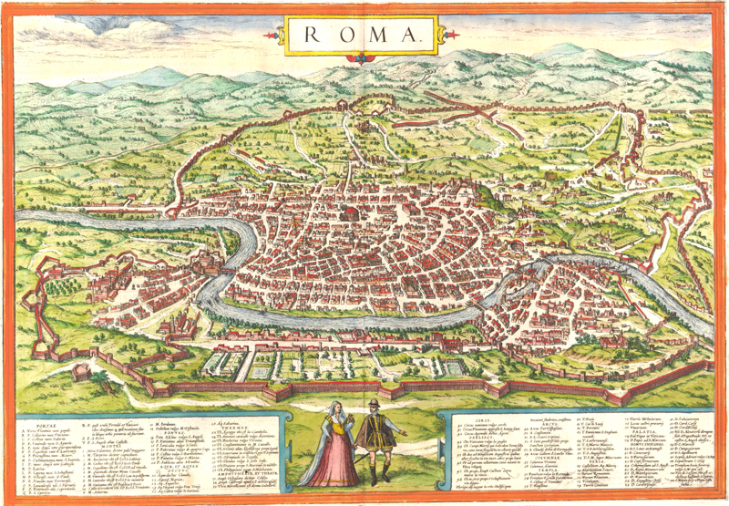
Roma.
The number of people who contributed to the Civitates Orbis Terrarum could seemingly fill an entire city. The product of their combined effort and wisdom ignited a vogue for townbooks that continued unabated into the 1700s -- and the enthusiasm for their city plans still has not died down. Over the course of a century, Braun and Hogenberg's plates were acquired by Joannes Jansson, Frederick de Wit, Pieter van der Aa, and Covens and Mortier, and they were copied by many others. To this day, map enthusiasts, history buffs, and collectors continue to be drawn to their beauty, detail, and historical significance. As influential architect and urbanist Rem Koolhaas suggests in his foreword to Taschen's excellent 2008 reprint of the Civitates, Braun and Hogenberg's city plans preserve the moment when European society transitioned from "a feudal/religious order to a more mercantile, market-driven modernity." Perhaps that is why the plans and views endure: they provide a snapshot of the cities of the world just as they were beginning to become what they are today.
References
Elliot, James, "Braun & Hogenberg and After: The Town Plans of the 17th Century," British Library, https://www.bl.uk/picturing-places/articles/braun-and-hogenberg-and-after-the-town-plans-of-the-17th-century (accessed 11/30/17).
Füsell, Stephan (editor), Civitates Orbis Terrarum – Cities of the World, Taschen GmbH, 2008.
Goss, John, The City Maps of Europe – 16th Century Town Plans from Braun & Hogenberg, Rand McNally, 1991.