Somewhere between myth and mistake lies the island of California, perhaps the most famous and conspicuous cartographic fallacy in the world of antique maps. Even novice map collectors have surely come across examples of this fantastical geographical error in their browsing. It is hard to miss, so peculiar it seems to the modern eye: a vaguely carrot- or rocket-shaped land mass detached from the western coast of North America, floating in the Pacific Ocean. Once the initial novelty of an insular California fades, the questions begin: where did this misconception start? How did it evolve and persist? When and how did it finally end?
Before California was established as an actual place, it was a fantasy invented by Garci Rodríguez de Montalvo, a Castilian author of chivalric romances. In 1510 Montalvo published Las sergas de Esplandián, his addition to the chronicles of Amadís de Gaula. The work was an international hit, translated into a number of languages, and an influence on Don Quixote, the novel, and Don Quixote, the character, who admires and models himself after Amadís. In the story Montalvo describes an island paradise "to the right hand of the Indies" populated only by Amazonian black women, protected by griffins, and larded with gold. The name of this island of wonders: California.
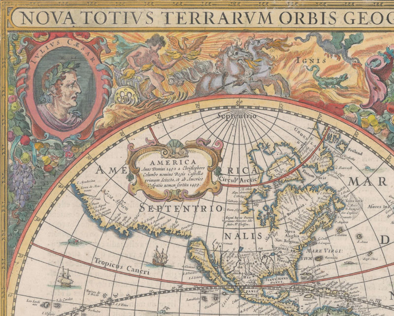
Henricus Hondius, Nova Totius Terrarum Orbis Geographica ac Hydrographica Tabula, 1630.
The Spanish explorers in New Spain were familiar with Montalvo's tale and seduced by the idea of an island like his California. One such explorer was the madly ambitious conquistador Hernán Cortés, who in 1533 sent an expedition north along the coast of New Spain to locate a trio of lost ships. One of the expedition's two ships, the Concepción, was taken over by its mutinous pilot, Fortún Ximénez, a man who, according to Dora Beale Polk, was "as obsessed as Cortés with the dream of island paradises." Ximénez steered the ship to a site near present-day La Paz and became the first European to land in Baja California. Before he had an opportunity to draft a report or map the area, Ximénez was slain by natives. Surviving crew members brought back word of the land that they mistook for an island. Following up on their reports, Cortés himself began exploring the Baja California region in May 1535. Traveling about 200 miles up both the gulf and Pacific coasts from Cabo San Lucas, Cortés determined that the land was indeed an island, in part because (per Polk) "nothing he saw on the voyage could have called into doubt the island theory." The "island" was given the name of California.
Surprisingly, the myth that California was an island was debunked pretty quickly -- at least temporarily. In the years following Cortes' journey up the coast, further explorations by Cortes' lieutenant Francisco de Ulloa (1539-40), Hernando de Alarcón (1540-41), and Melchor Díaz (1540-41) confirmed that in reality California was a peninsula. Other than an outlier of a map published in 1542 by Alonso de Santa Cruz that depicts the southern peninsula as an island called "ysla que descubrió el marqués del valle (Cortés)", most of the maps showing the region from the mid-to-late 16th century -- from the likes of Giovanni Batista Agnese, Gerard de Jode, Bolognini Zaltieri, and Ortelius and his successors Mercator and Hondius -- accurately depicted California as peninsular. The region was still widely referred to as California, like Montalvo's fictitious island, but it was not the bountiful island of which Cortés, Ximénez, and their Spanish backers had dreamed.
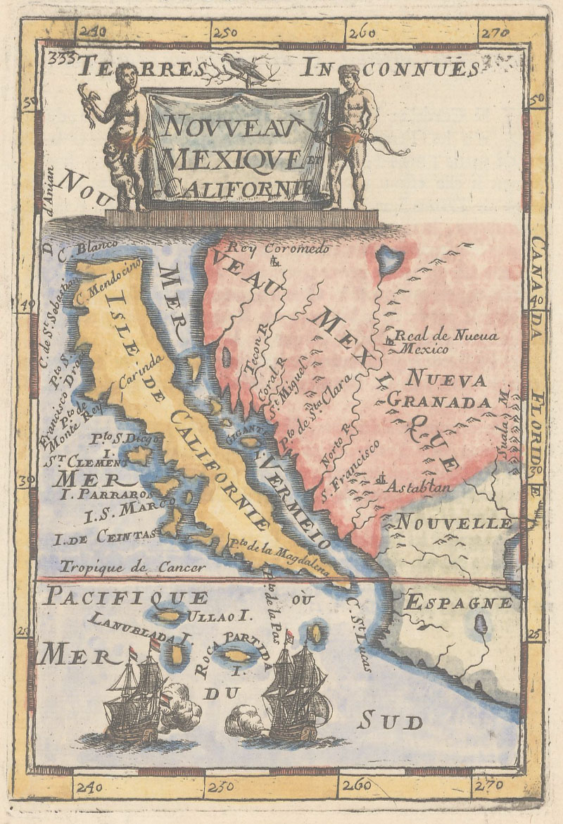
Alain Manesson Mallet, Nouveau Mexique et Californie, 1683.
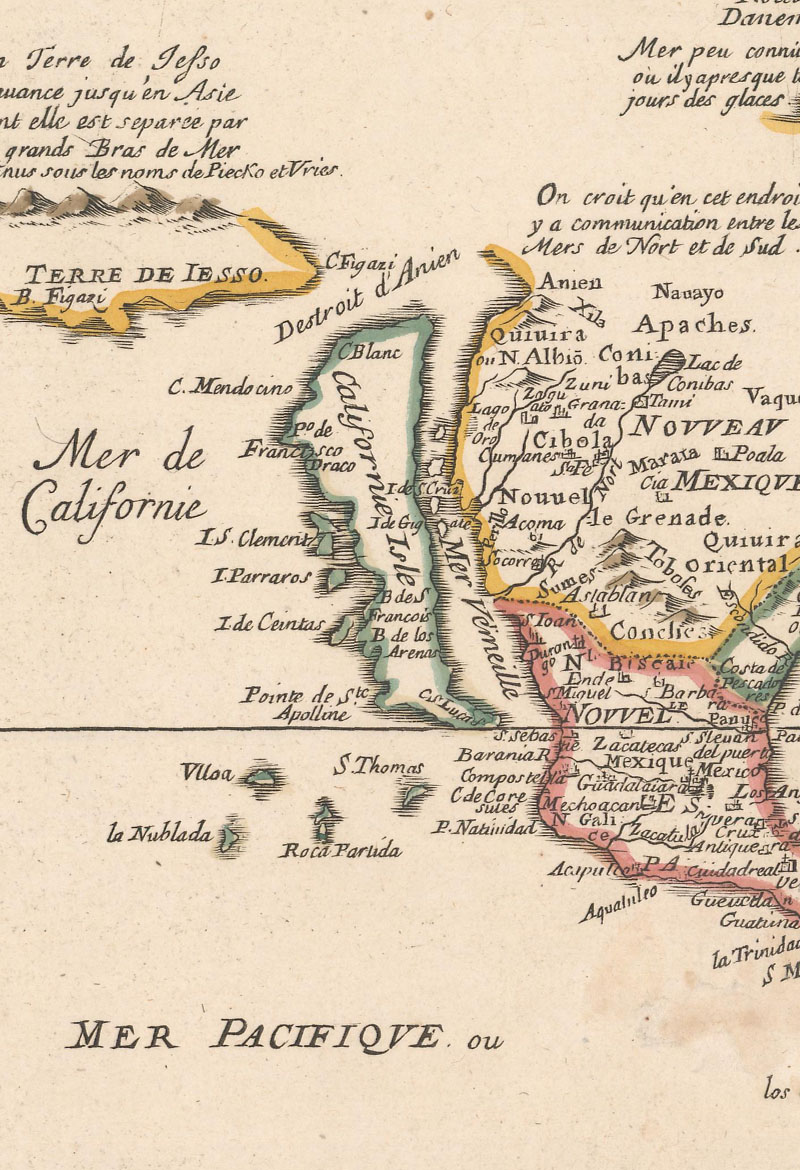
Pierre Duval, L'Amerique Autrement le Nouveau Monde et Indes Occidentales, 1684.
The myth of an insular California reemerged as the Spanish became fixated on discovering a more direct route between the trade centers in Asia and Europe, an obsession in part fueled by the paranoid belief that the English had already found a passage through North America called the Northwest Passage (from the east) or the Strait of Anián (from the west). Throughout the latter half of the sixteenth century, reports and rumors circulated that the Gulf of California was in fact a strait connected to the Strait of Anián, but one man is traditionally credited with popularizing this belief, and, by extension, the legend that California was an island: Friar Antonio de la Ascensión. Ascensión was an uneducated, inexperienced, and remarkably imaginative Barefoot Carmelite serving as an assistant cosmographer on the 1602 expedition of Sebastián Vizcaíno. Vizcaíno's mission was to establish a site for Spanish trade ships from the Philippines to regroup, restock on provisions, and avoid attacks from British privateers as well as to find the straits of California and Anián. According to Ascensión, the expedition located the latter; in an account of the journey written and published several years after the end of the mission, he asserts that the "Mar de Cortes" (the Gulf of California) "goes on to communicate with the ocean of the north by the Strait of Anián." Despite having no first-hand evidence that California was an island, Ascensión wrote, "I hold it to be very certain and proven that the whole Kingdom of California discovered on this voyage, is the largest island known or which has been discovered up to the present day." This wild conjecture took hold thanks to what Polk refers to as "uncritical repetition," and beginning in 1622, California began to regularly appear as an island on maps.
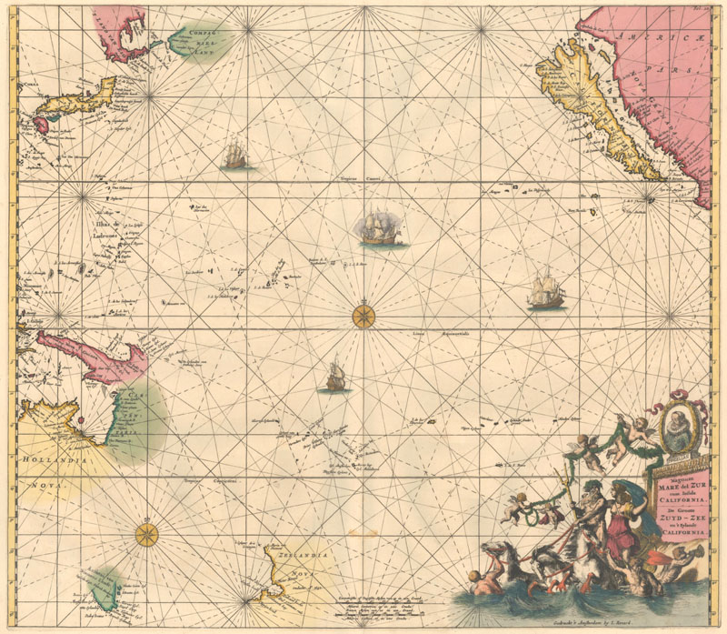
Renard/De Wit, Magnum Mare del Zur cum Insula California, 1715.
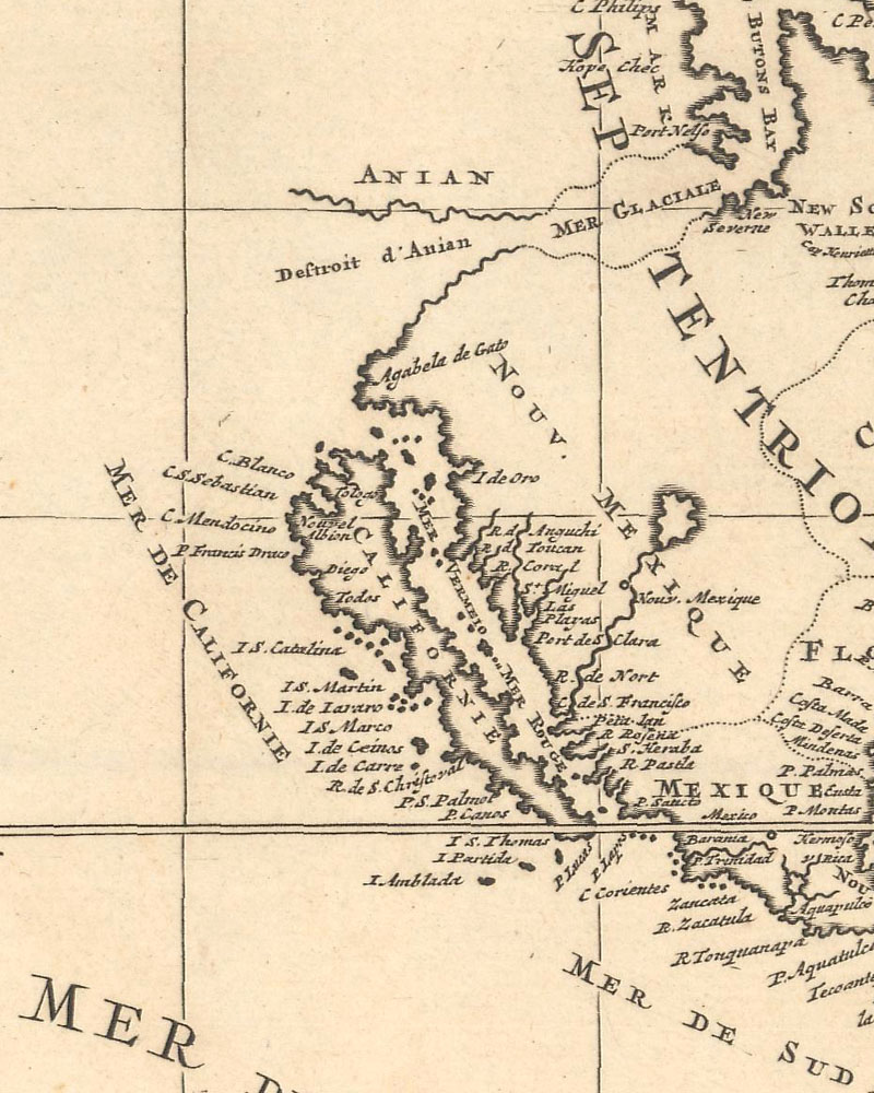
The first map to show California as an island appeared on the title page of Antonio de Herrera y Tordesillas's Descripcion des Indes Occidential. It was based on the map accompanying Ascensión's report to the Council of the Indies and the King of Spain in 1620, which was stolen from a Spanish vessel by the Dutch, who began to spread the California-as-an-island myth themselves. The simple map depicts the Americas without any interior detail, with California completely separated from the western coast of North America by a narrow strait. Early maps portraying the region by Abraham Goos (1624), Henry Briggs (1625), and John Speed (1626) showed the island with a flat northern coast. This model persisted until 1656, when Nicholas Sanson published his influential Audience de Guadalajara, Nouveau Mexique, Californie, &c., which popularized presenting the island with an indented northern coastline. Sanson based the geography on a map from Luke Foxe, an English explorer whose trip to find the Northwest Passage was perhaps most notable for its complete lack of casualties. A third cartographic variation on insular California emerged nearly a century later with George Matthaus Seutter's Nov. Orbis sive America Septentrionalis… (1740), which depicts the island narrowing considerably south of modern-day San Diego, almost to the point of splitting into two islands, reflecting a theory of Father Luis Velarde, another Jesuit missionary who theorized that California was two islands after questioning natives about the geography of the region.
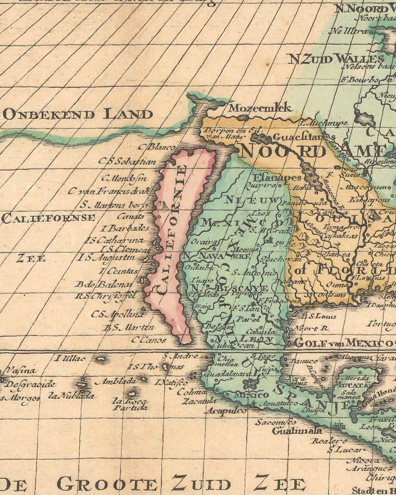
Glen McLaughlin's exhaustive and invaluable The Mapping of California as an Island: An Illustrated Checklist lists over 250 examples of maps featuring the supposed island, starting with Herrera y Tordesillas's 1622 title page and ending with a few nineteenth century Japanese maps, the latest of which was published in 1865, well after California had been explored, populated, and admitted as a state into the United States of America. How did this misconception persevere for more than two centuries? After Vizcaíno's expedition passed through the region, California remained an enigma for at least another century. Part of the problem was that the area was extremely difficult to explore by land or sea. Explorers in the region faced harsh weather, starvation, and disease, and the pay-off for their struggle was not immediately apparent -- this was not the fantasy land of riches Montalvo dreamed up. As Spain's status as a world power plummeted, they had fewer resources to pump into exploring and developing the region, and the population of colonists already there was too sparse to spread throughout such a massive area. Even after empirical evidence proved that California was attached to the continent, map publishers kept propagating the myth, whether out of ignorance, thriftiness (modifying a copperplate was a costly procedure), or, perhaps, a stubborn adherence to old lore.
It was the Jesuit missionary, explorer, and cartographer Eusebio Kino who definitively proved that California was a peninsula and not an island, although it took well over a century for his efforts to be widely recognized as the indisputable truth. Kino arrived in Baja in 1681 believing that California was a peninsula as he was taught during his education in Ingolstadt, but soon after his arrival in Mexico he switched to the dominant view that it was an island. Yet the more he saw of the region, the more he began to doubt the island theory. Unlike the Carmelites, who favored unchecked speculations to hard science, the Jesuits were deeply disciplined and scientific, and Kino was no exception. After he was relocated to present-day southern Arizona, Kino began investigating California's alleged insularity, driven by a general need to know the truth as well as a desire to find an easier way to communicate with and support his Jesuit brothers settled in Baja. From 1698 to 1701, Kino built the case that California was a peninsula, writing in 1701, "I have discovered with minute certainty and evidence, with mariner's compass and astrolabe in my hands, that California is not an island but a peninsula, or isthmus, and that in thirty-two degrees of latitude there is a passage by land to California, and that only to about that point comes the head of the Sea of California." In 1705 his map, Passage par Terre a la Californie…, was published. It was the first map to accurately depict the region, in particular the relative positions of the Colorado and Gila rivers and the correct localization of the rivers, valleys, and mountains of part of Sonora and Arizona.
Even after Kino's discovery, the world was slow to come around to the reality of California as a peninsula. Cartographer and publisher Herman Moll refused to acknowledge that it was not an island, writing in 1711, "I have had in my office mariners who have sailed around it." Many of Kino's own colleagues shrugged off his findings, although Jesuit brethren like Juan de Ugarte and Fernando Consag followed up on his work, the former traveling up the Gulf of California as far as his craft would allow in 1721, and the latter surveying the gulf completely in 1746. Consag's efforts led King Ferdinand VII to issue a royal decree in 1747 that stated in no uncertain terms that "California is not an island." Although it would take more than a hundred years after Ferdinand's decree for the island of California to completely disappear from maps, the number began to greatly decrease in the latter half of the eighteenth century.
Pierre Mortier, Carte Generale du Monde, ou Description du Monde Terrestre & Aquatique, 1700.
Jan de Lat, Kaartje van het Noorder-Deel van America, 1747.
The legend of an insular California may be long dead, but its legacy lives on today in antique maps. Collectors still find themselves fascinated by what W. Michael Mathes calls "possibly the most attractive phenomenon in the history of cartography," drawn to its strangeness, its romance, and what it says about cartography in the days before the Enlightenment, when outlandish speculation could be taken as fact if it was just repeated often enough. Perhaps because its early history was so intertwined with fantasy, California still has a mythical air about it to this day. After examining enough maps that show California as an island, it is not too hard to imagine the possibility of a Golden State adrift in the Pacific, its own isolated terrain, a world apart from the rest of the continent.
All of the map images that appear above will be listed in our August 31 - September 14 auction.
References:
Lindsey, Jennifer (ed.), "The Island of California – A Persistent Fallacy," Mercator's World, Volume 1, Number 2, Eugene, OR , 1996.
Mathes, W. Michael, "Traditional, Possible, and Desirable: Origins of the Island of California," Mercator's World, Volume 1, Number 6, Eugene, OR , 1996.
McLaughlin, Glen, The Mapping of California as an Island: An Illustrated Checklist, The California Map Society, 1995.
Polk, Dora Beale, The Island of California – A History of the Myth, The Arthur H. Clark Company, Spokane, Washington, 1991.
Warren, Bill, "When California Was an Island," Mercator's World, Volume 6, Number 3, Eugene, OR , May/June 2001.