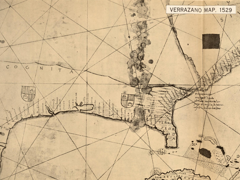
Giovanni da Verrazano (or Verrazzano) (1485-1528) was born near Florence, Italy, and settled in the port city of Dieppe, France around 1506. His first voyage to the Americas was on board the ship La Pensee, captained by Thomas Aubert, who explored the region around Newfoundland. After the circumnavigation of the globe by Ferdinand Magellan's crew, there was increased pressure for France to enter the lucrative trade business and compete with Spain and Portugal. In 1523, King Francis I commissioned Verrazano to set sail for the new world and explore the region between Florida and Newfoundland, with the purpose of finding a sea route to the Pacific Ocean. The following year, aboard the ship La Dauphine with sufficient provisions for an eight-month voyage, Verrazano headed for the Americas. Around March 1, 1524, Verrazano's ship landed near Cape Fear, North Carolina, around 34 degrees north. After a brief stay, he headed north along the Outer Banks, which Verrazano described as "an isthmus a mile in width and 200 long." Beyond the Outer Banks Verrazano was able to see Pamlico Sound, the largest lagoon along the eastern coast of the US. Verrazano mistook the Pamlico and Albemarle Sounds as the Pacific Ocean, and thus the myth of the Sea of Verrazano began.
In a letter to King Francis I, Verrazano describes this body of water:
"From the ship, was seen the oriental sea between the west and north. Which is the one, without doubt, which goes about the extremity of India, China and Cathay. We navigated along the said isthmus with the continual hope of finding some strait or true promontory at which the land would end toward the north in order to be able to penetrate to those blessed shores of Cathay. To which isthmus was given by the discoverer [the name] Verrazanio: as all the land found was named Francesco for our Francis."
Despite the existence of inlets to Pamlico and Albemarle Sounds, Verrazano likely overlooked them due to the coastal shoals in the area. Verrazano continued north past the Outer Banks, and although he also missed the entrances to the Chesapeake Bay and Delaware Bay, he became the first European to enter New York Bay and the Hudson River and describe them in detail. His ship again ventured north to Narragansett Bay, making landfall in Newport before heading to Cape Breton and Newfoundland. With his provisions dwindling, Verrazano decided to end the journey and headed back to Dieppe, France, arriving in early July, 1524.
Although he didn't succeed in finding a passage to the Pacific, Verrazano's geographical and topological description of his expedition remains the earliest known report of a continuous voyage along the eastern coast of North America. His crew frequently saw fires along the shore and other signs of Native Americans, and made landfall on numerous occasions to explore the land. They experienced encounters with several different Native American tribes, which Verrazano described in his report along with information on the flora and fauna. Most of the encounters were friendly with the exchanging of gifts, but Verrazano describes one tribe, believed to be around the coast of Maine, to be "full of crudity and vices, and were so barbarous that we could never make any communication with them." The primary surviving written account of Verrazano's voyage is a letter written in Italian by a scribe, with annotations apparently by Verrazano himself, and was written on July 8, 1524 from Dieppe. The letter is known as the Cèllere Codex, as it was discovered in the Library of Count Giulio de Cèllere, Rome, in 1909. Now housed at the Pierpont Morgan Library in New York, the letter was written to Francis I, and was likely a draft that was to be translated into French and dispatched to the king.
Image courtesy of David Rumsey Map Collection, from the Atlas of the Historical Geography of the United States, by Charles O. Paullin, Carnegie Institution of Washington, 1932.
Although there is no surviving map drawn by Verrazano depicting his voyage, his brother, cartographer Gerolamo da Verrazano, did create a large manuscript map of the world on vellum, currently in the possession of the Vatican Library. Gerolamo's map was created five years after his brother's voyage, and is one of the first maps to incorporate Giovanni's discoveries. The map depicts the Pacific Ocean extending to the eastern coast of North America around the location of the Carolinas, with an adjacent notation: "From this sea one beholds the western sea; there are six miles of land between the two."
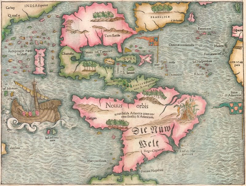
One of the earliest printed maps to depict the Sea of Verrazano is Sebastian Munster's map of the New World (along with his corresponding world map). The map was issued in Munster's edition of Ptolemy's Geographia from 1540 to 1578. The map depicts a large sea that nearly bisects North America, although the sea remains unnamed. Munster's Geographia proved to be very successful, appearing in forty editions and making this map one of the most widely circulated maps of the New World at the time. As a result, Munster's map served to popularize the belief in a Northwest Passage, thereby encouraging more exploration of the area by both the French and the British.
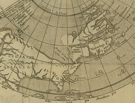
Another printed example of the Sea of Verrazano appears on Michael Lok's map of North America from 1582, published in Richard Hakluyt's rare publication, Divers Voyages Touching the Discoverie of America. It is believed that Lok used Gerolamo de Verrazano's manuscript. In the dedication, Hakluyt explains the source of the map as: "an old excellent mappe, which he [Verrazano] gave to king Henrie the eight, and is yet in the custodie of master Locke." The map clearly depicts the Pacific extending nearly to the Atlantic Ocean, separated only by a narrow isthmus around the 40th parallel north. At its closest point to the Atlantic, the sea is labeled "Mare de Verrazana 1524." Although Verrazano's sea had already been largely discredited, Lok's motivation in depicting it was due to his leadership in the movement to stimulate English colonization of the New World. Verrazano's Sea served as a promise of an easier passage to the Orient, a lucrative proposition for the British. Lok's map was one of the reasons that Roanoke Island, between Pamlico Sound and Albemarle Sound, was selected as the site for a new British colony, established by Sir Walter Raleigh in 1584.
Appearances of the false Sea of Verrazano appeared on maps for nearly 100 years, due primarily to three factors. First and foremost was a lack of exploration of the area. Distance, cost, rough seas, hostile Natives, the challenge of navigating an unknown land, and other elements all contributed to a deficiency of knowledge of the New World. Wishful thinking on the part of Europeans was clearly a second factor. The French and British in particular, who did not have routes to access the lucrative trade industry in the East, hoped for a way to gain access to trade. The third factor was politics, since perpetuating the myth allowed those promoting colonial expansion to secure investors and gain charters from a sovereign. Although Verrazano's expedition did not succeed in its ultimate goal of finding a Northwest Passage, it did serve an important purpose in encouraging exploration and colonization of the New World. Maps depicting the false Sea of Verrazano epitomize the evolving awareness of the geography of the Americas.
References:
Baynton-Williams, Ashley, Geographical Misconception: The False Sea of Verrazzano, MapForum Issue 1, London, Spring 2004.
Burden, Philip, The Mapping of North America, Raleigh Publications, London, 1996.
Cumming, W. P., The Southeast in Early Maps, The University of North Carolina Press, Chapel Hill, 1973.
Cumming, W. P., Skelton, R. A., & Quinn, D. B., The Discovery of North America, American Heritage Press, New York, 1972.
Fite, Emerson D. & Freeman, Archibald, A Book of Old Maps, Arno Press, New York, 1969.
Nebenzahl, Kenneth, Atlas of Columbus and the Great Discoveries, Rand McNally, Genoa, Italy, 1990.
William F. E. Morley, Verrazzano, Giovanni da, in Dictionary of Canadian Biography, vol. 1, University of Toronto/Université Laval, 2003–, accessed March 12, 2015, http://www.biographi.ca/en/bio/verrazzano_giovanni_da_1E.html.
History of Papermaking for Map Collectorsby Marti Griggs
This article is an excerpt from the new edition of Collecting Old Maps, by F.J. Manasek, revised and expanded by Marti and Curt Griggs. This highly anticipated reference work is an essential guide for map collectors of all types, with information on the basics of map collecting, the art of mapmaking, the history of printed maps over five centuries, identifying forgeries, understanding condition and conservation, building a map collection in the digital age, and much more. The book is profusely illustrated with full-color images from nearly 200 maps. The second edition of Collecting Old Maps can be pre-ordered now, with a special discount available through March 31, 2015. Please click here for more details. (Old World Auctions does not own or have a stake in Collecting Old Maps, and OWA has neither received nor been promised any form of compensation for any sales of Collecting Old Maps.)
An antique map is more than just a geographic image. It resulted from the collaborative efforts of explorers, surveyors, draftsmen, engravers and printers. But the paper on which it is printed is also an important part of the map. Thus, understanding the evolution of papermaking technology can add to our enjoyment of maps.
In the early European papermaking process, cellulose fibers were obtained from linen rags. The collection and distribution of rags to the paper mills was an industry in itself, similar to today’s recycling industry. Once at the mill, rag selection took a skilled eye to judge the quality and suitability of the old rags that would serve as the feedstock for high-grade paper.
This illustration from Diderot’s Encyclopédie shows women sorting rags. A carefully sorted batch with similar weight, color and so-called tenderness ensured predictable results during subsequent operations.
After sorting, the rags went through a long series of soaking, rinsing and washing cycles where a copious supply of clear, fresh water was critical. Prior to the use of bleach, in about 1800, whitening involved boiling the rags in a solution of soda ash or lye, which could take weeks to bring the rags to the desired whiteness.
The next step, called retting, gave paper its uniformity, softness and weight. This fermentation process could take up to a month and required a superb instinct combined with experience, not unlike the wizardry employed by a fine winemaker. If stopped too early the resulting paper was course and stiff, if left too long it resulted in a useless, wasted batch.
At this point, the rags were clean, whitened and degraded through fermentation, but still roughly in the form of cloth. The beating, or stamping, step took this solid mass through a progressive set of hammers to produce the slurry for the papermaker’s mold.
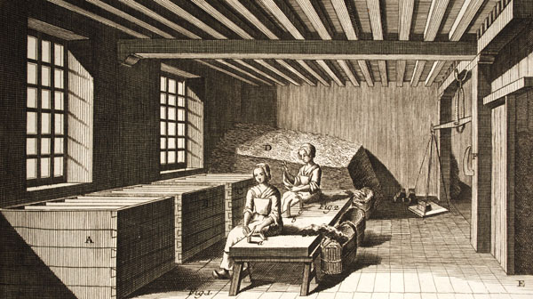
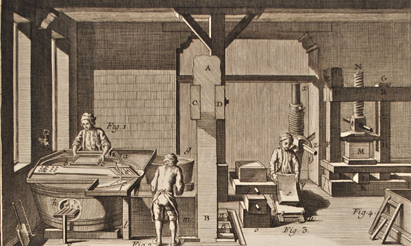
Forming the paper sheet required coordination between the vatman, coucher and the layman. The vatman dipped the paper mold and deckle frame into a vat of slurry to gather and evenly distribute the pulp on the mold. The vatman passed the mold to the coucher who removed the deckle and returned it to the vatman who fitted it to another mold. The coucher gently removed the wet, delicate sheet of paper from the mold and placed it between layers of felt to build up a pile called a post. The layman then put the post in a screw press to remove the water. This required several pressings, between which, the layman restacked the paper sheets interleaved with dry felt. The sheets were then hung to complete the drying process.
This illustration shows the vatman, coucher and layman at work. A skilled team could make a few thousand sheets in one day.
After drying, each sheet had to be sized to reduce absorbency, strengthen its fiber and make it suitable to hold ink and color. The sheet was dipped in a vat of gelatin and again hung up to dry. It was then burnished with a flat stone to close the pores of the paper and produce a smooth surface. Finally, the paper was complete and ready for the printer.
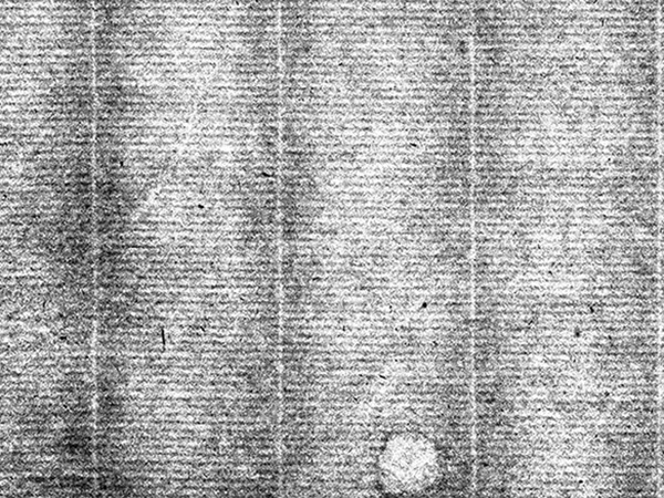
Paper was made in this manner for hundreds of years with minor technological improvements. The visible lines left by the paper mold and the uneven distribution of the long cellulose fibers characterize this type of paper, which is known as laid paper.
The distinct appearance of laid paper can most easily be seen when the paper is held up to a light. Chain lines are vertical; laid lines are horizontal. Note the irregularity of the lines and the visible flaws in the paper.
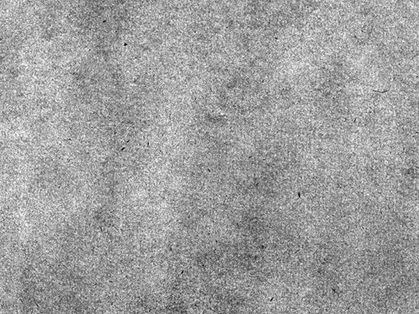
The development of wove paper in the latter part of the 18th century was a significant papermaking refinement. James Whatman, an English papermaker, developed a finer woven metal mesh mold that created paper with a much smoother surface. By the 1780s it was widely used in England, and by the turn of the century it was being incorporated at mills in France and America.
The mold used to produce wove paper is made of a very fine mesh which do not leave a distinctive impression in the paper. While the sheet is smoother than the laid paper, it still exhibits irregularity in the distribution of the cellulose fibers.
Even with this advancement, all paper was still being made by hand, one laborious sheet at a time. It was the invention of the papermaking machine in the early 1800s that revolutionized the papermaking industry. The machine used a fine mesh of woven wire around the outside of a drum that rotated slowly through a vat of paper slurry, gathering and consolidating the fiber as it rose out of the vat, where it was lifted off the mesh by an adjacent felt covered drum rotating in synchronization with the wire drum. It then passed through a series of drying cylinders into the calender section where the dried paper was smoothed in a series of hard pressure rollers.
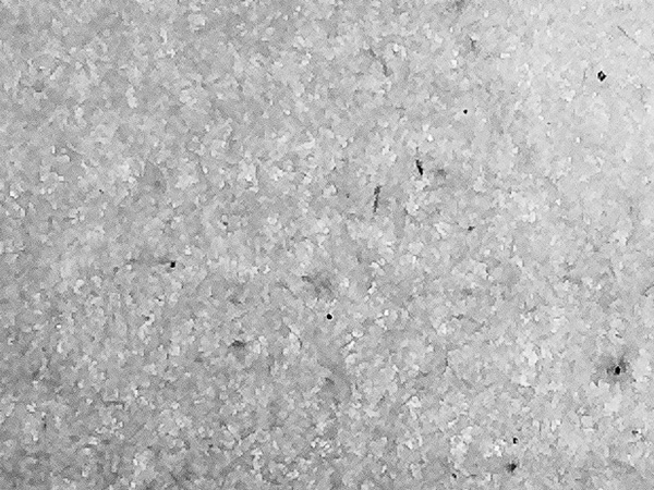
The Industrial Age gradually expanded the middle class, creating a growing market for virtually all things, including paper. The invention of the papermaking machine coincided with the increased demand for paper, but the continued use of rags was a bottleneck to the growing industry. A new and plentiful source of raw materials was urgently needed to sustain the new demand for paper. The search quickly turned to wood and by the middle of the 19th century methods were developed to use wood pulp for making paper.
Paper made from wood pulp is characterized by short fibers and a very smooth, uniform surface.
Understanding the papermaking process and close inspection of paper are important steps in dating a map, or suggesting a forgery. One of the first things a person should do when examining an old map is to carefully analyze the paper. Is the paper consistent with the date the map is purported to have been made? Is it laid or wove paper? Is it rag-based or wood-based? Occasionally paper may contain a most helpful dated watermark, but most of the time the type and construction of the paper will provide a rough idea of when it was made. These are the key points to remember:
Paper was principally rag-based until the middle of the 19th century.
Paper was laid paper until the last quarter of the 18th century.
Wove paper was the most common paper in the first half of the 19th century.
Machine-made, wood-based paper dominated the printing industry after about 1850.