Showing Featured Lots(remove filter)
Showing results for:Auction 184
Catalog Archive
77 lots
Page 1 of 2
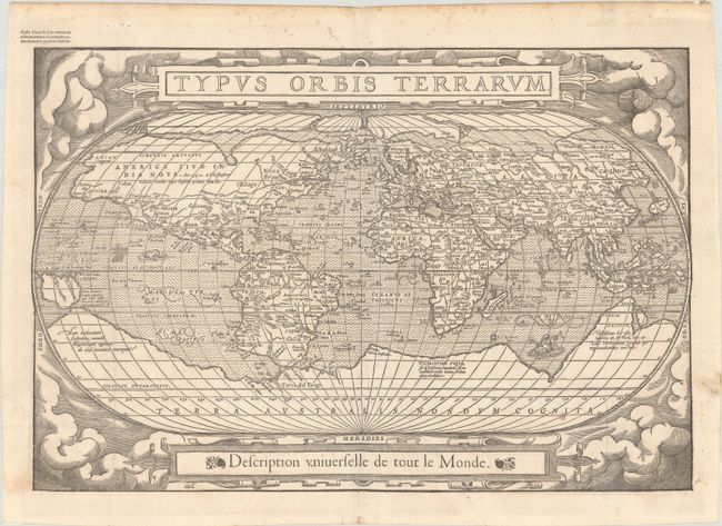
Auction 184, Lot 4
Subject: World
Belleforest, Francois
Typus Orbis Terrarum, 1575
Size: 19.6 x 13.2 inches (49.8 x 33.5 cm)
Estimate: $3,750 - $4,750
Scarce Woodcut Version of Ortelius’ World Map
Sold for: $2,500
Closed on 9/15/2021
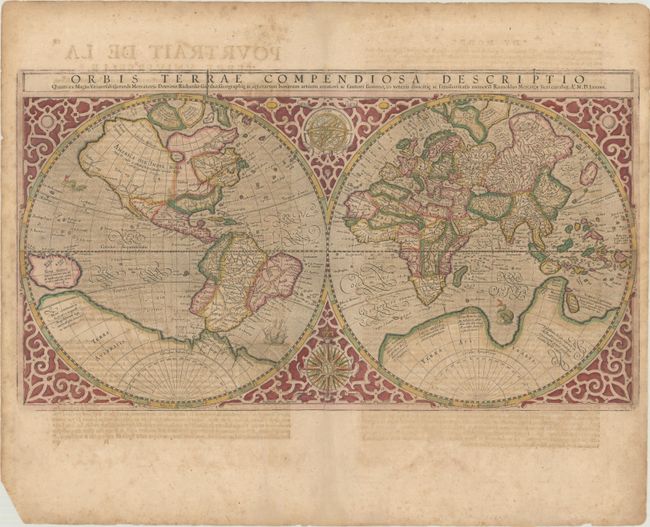
Auction 184, Lot 5
Subject: World
Mercator, Rumold
Orbis Terrae Compendiosa Descriptio quam ex Magna Universali Gerardi Mercatoris, 1587
Size: 20.8 x 11.4 inches (52.8 x 29 cm)
Estimate: $4,500 - $5,500
Mercator's Double-Hemisphere World Map in Full Contemporary Color
Sold for: $4,000
Closed on 9/15/2021
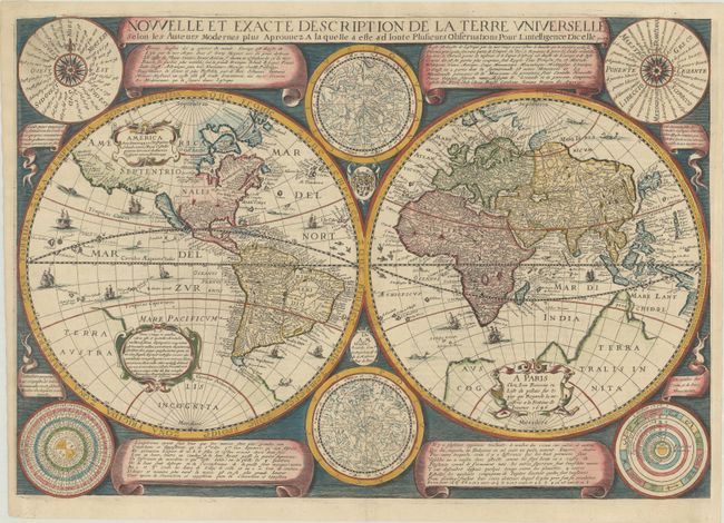
Auction 184, Lot 9
Subject: World
Boisseau, Jean
Nouvelle et Exacte Description de la Terre Universelle Selon les Auteurs Modernes Plus, 1646
Size: 21.6 x 15.1 inches (54.9 x 38.4 cm)
Estimate: $5,500 - $6,500
Decorative Map with California as an Island
Sold for: $4,000
Closed on 9/15/2021
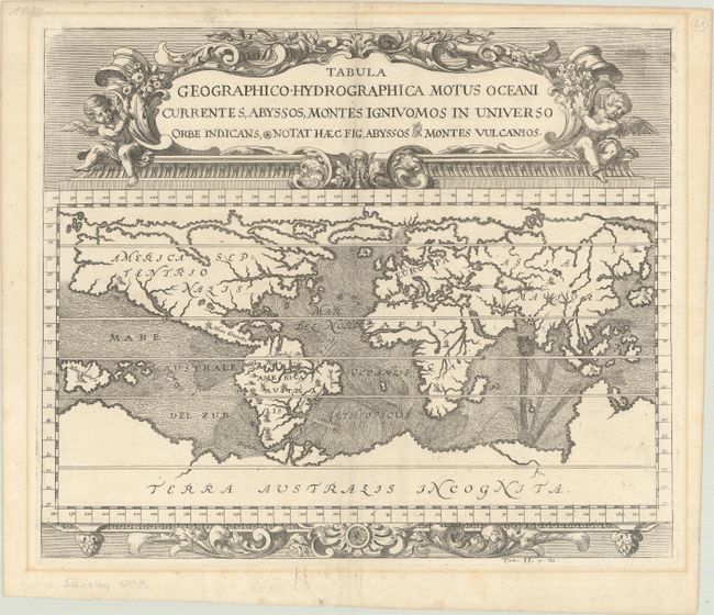
Auction 184, Lot 12
Subject: World
Zahn, Johannes
Tabula Geographico-Hydrographica Motus Oceani Currentes, Abyssos, Montes Igniuomos in Universo Orbe Indicans, Notat haec Fig. Abyssos Montes Vulcanios, 1696
Size: 16.6 x 13.9 inches (42.2 x 35.3 cm)
Estimate: $1,900 - $2,200
Early Example of Thematic Cartography
Unsold
Closed on 9/15/2021
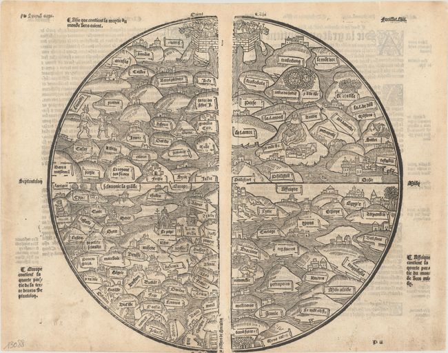
Auction 184, Lot 42
Subject: Ancient World
Anon.
[Untitled - Ancient World], 1553
Size: 12.9 x 11.9 inches (32.8 x 30.2 cm)
Estimate: $18,000 - $20,000
Rare Medieval World Map
Sold for: $13,500
Closed on 9/15/2021
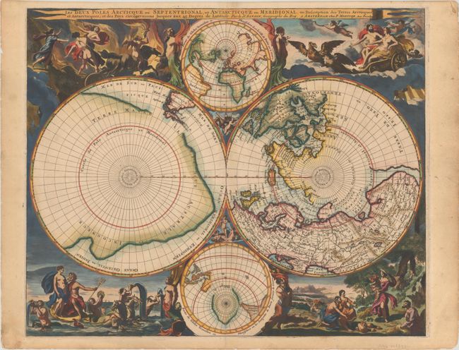
Auction 184, Lot 47
Subject: Polar
Sanson/Mortier
Les Deux Poles Arcticque ou Septentrional, et Antarcticque ou Meridional, ou Description des Terres Arctiques et Antarcticques..., 1720
Size: 20.9 x 17.2 inches (53.1 x 43.7 cm)
Estimate: $4,000 - $4,750
Mortier's Lavish Map of the Poles
Sold for: $3,000
Closed on 9/15/2021
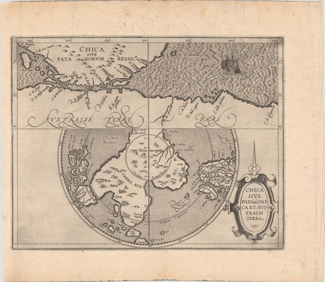
Auction 184, Lot 51
Subject: South Pole, Antarctica
Wytfliet, Cornelis
Chica sive Patagonica et Australis Terra, 1597
Size: 11.4 x 8.9 inches (29 x 22.6 cm)
Estimate: $1,600 - $1,900
Early Map of Terra Australis and the Strait of Magellan
Sold for: $1,700
Closed on 9/15/2021
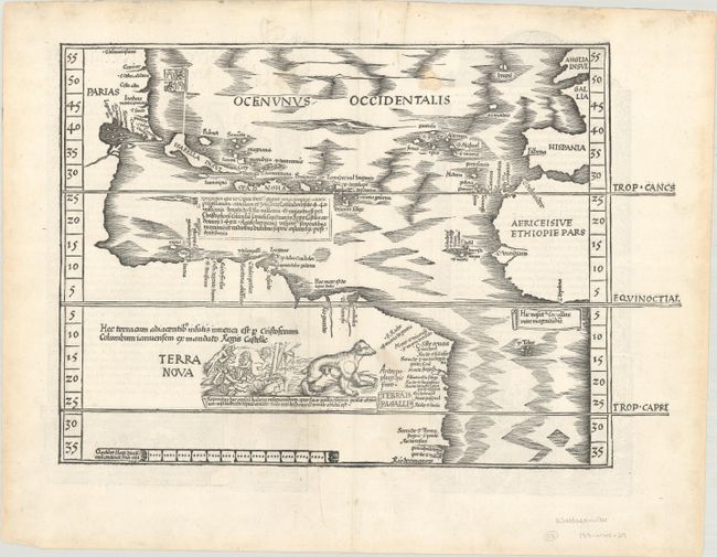
Auction 184, Lot 72
Subject: Western Hemisphere - America, Atlantic Ocean
Waldseemuller/Fries
[Title on Verso] Oceani Occidetalis seu Terre Nove Tabula, 1525
Size: 16.6 x 11.3 inches (42.2 x 28.7 cm)
Estimate: $8,000 - $9,500
The Waldseemuller/Fries "Admiral's Map"
Sold for: $9,500
Closed on 9/15/2021
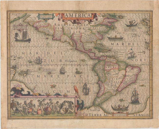
Auction 184, Lot 73
Subject: Western Hemisphere - America
Hondius, Jodocus
America, 1619
Size: 19.8 x 14.8 inches (50.3 x 37.6 cm)
Estimate: $3,000 - $3,750
Hondius' Important Map of the Americas in Full Contemporary Color
Sold for: $2,200
Closed on 9/15/2021
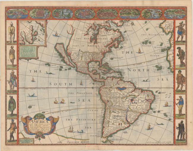
Auction 184, Lot 75
Subject: Western Hemisphere - America
Speed, John
America with Those Known Parts in That Unknowne Worlde Both People and Manner of Buildings Discribed and Inlarged, 1626
Size: 20.2 x 15.5 inches (51.3 x 39.4 cm)
Estimate: $7,000 - $8,500
Speed's Popular Carte-a-Figures Map of the Americas
Sold for: $5,000
Closed on 9/15/2021
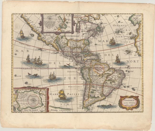
Auction 184, Lot 76
Subject: Western Hemisphere - America
Hondius, Henricus
America Noviter Delineata, 1631
Size: 19.8 x 14.8 inches (50.3 x 37.6 cm)
Estimate: $2,000 - $2,300
Hondius' Decorative Map of the Americas in Full Contemporary Color
Sold for: $1,400
Closed on 9/15/2021
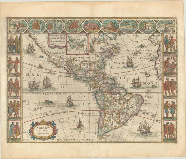
Auction 184, Lot 78
Subject: Western Hemisphere - America
Blaeu, Willem
Americae Nova Tabula, 1642
Size: 21.8 x 16.1 inches (55.4 x 40.9 cm)
Estimate: $4,750 - $6,000
Blaeu's Stunning Carte-a-Figures Map of the Americas in Full Contemporary Color
Sold for: $3,000
Closed on 9/15/2021
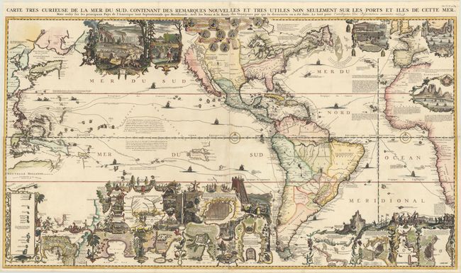
Auction 184, Lot 82
Subject: Western Hemisphere - America
Chatelain, Henry Abraham
Carte Tres Curieuse de la Mer du Sud Contenant des Remarques Nouvelles et Tres Utiles non Seulement sur les Ports et Iles de Cette Mer..., 1719
Size: 55.5 x 31 inches (141 x 78.7 cm)
Estimate: $13,000 - $16,000
Spectacular Wall Map Celebrating the New World
Sold for: $11,500
Closed on 9/15/2021
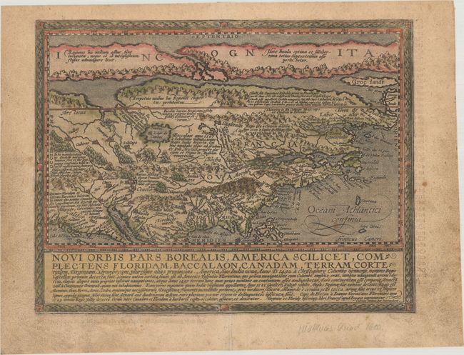
Auction 184, Lot 99
Subject: Colonial North America
Quad, Matthias von Kinckelbach
Novi Orbis Pars Borealis, America Scilicet, Complectens Floridam, Baccalaon, Canadam, Terram Corterialem, Virginiam..., 1600
Size: 11.6 x 9 inches (29.5 x 22.9 cm)
Estimate: $3,000 - $3,750
One of the Earliest Maps Devoted to North America
Sold for: $2,500
Closed on 9/15/2021
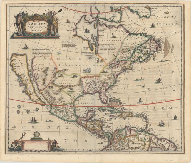
Auction 184, Lot 100
Subject: Colonial North America
Hondius/Jansson
America Septentrionalis, 1638
Size: 21.6 x 18.3 inches (54.9 x 46.5 cm)
Estimate: $2,750 - $3,500
One of the Most Important Maps Perpetuating the Myth of the Island of California - Rare First State
Sold for: $2,300
Closed on 9/15/2021
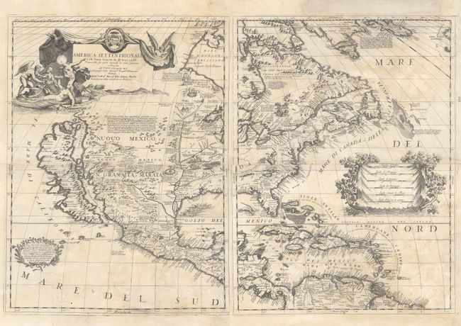
Auction 184, Lot 101
Subject: Colonial North America
Coronelli, Vincenzo Maria
[On 2 Sheets] America Settentrionale Colle Nuove Scoperte sin all' Anno 1688 Divisa Nelle sue Parti Secondo lo Stato Presente e Descritta..., 1688
Size: 17.9 x 23.8 inches (45.5 x 60.5 cm)
Estimate: $5,500 - $7,000
Coronelli's Stunning and Influential Map of North America with the Island of California
Sold for: $4,000
Closed on 9/15/2021
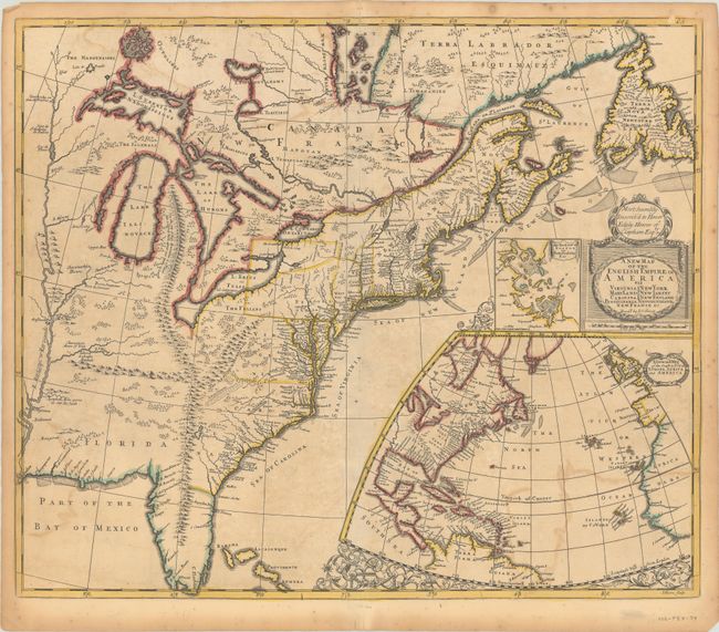
Auction 184, Lot 135
Subject: Colonial Eastern United States & Canada
Senex, John
A New Map of the English Empire in America viz Virginia Maryland Carolina Pennsylvania New York New Iarsey New England Newfoundland New France &c. , 1719
Size: 23.1 x 19.7 inches (58.7 x 50 cm)
Estimate: $2,000 - $2,300
Important Map of the American Colonies
Sold for: $1,500
Closed on 9/15/2021
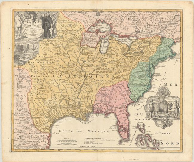
Auction 184, Lot 136
Subject: Colonial Eastern United States & Canada
Homann, Johann Baptist
Amplissimae Regionis Mississipi seu Provinciae Ludovicianae a R.P. Ludovico Hennepin Francisc Miss in America Septentrionali Anno 1687..., 1720
Size: 22.8 x 19.1 inches (57.9 x 48.5 cm)
Estimate: $2,400 - $3,000
Striking Map of Colonial America with Bison Vignette
Sold for: $1,300
Closed on 9/15/2021
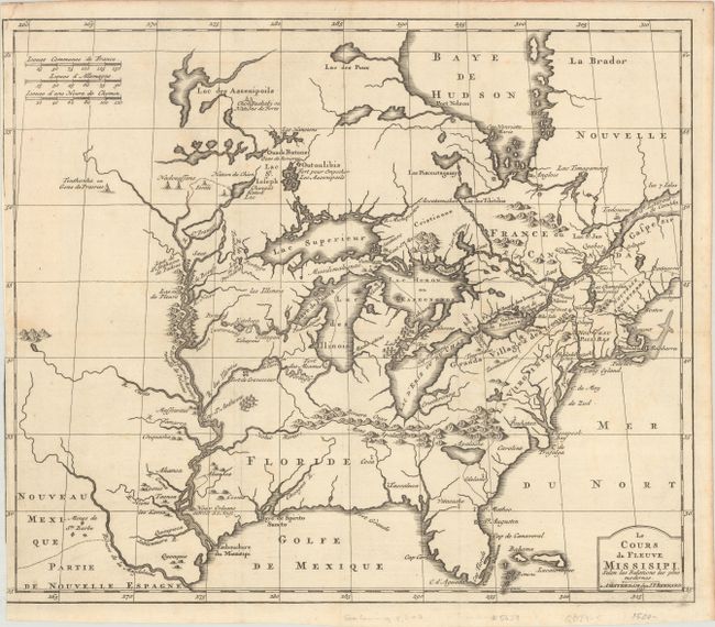
Auction 184, Lot 137
Subject: Colonial Eastern United States & Canada, Great Lakes
Bernard, Jean Frederic
Le Cours du Fleuve Missisipi, Selon les Relations les Plus Modernes, 1737
Size: 17.3 x 14.6 inches (43.9 x 37.1 cm)
Estimate: $1,600 - $1,900
Scarce and Desirable Early Hennepin Variant
Sold for: $1,200
Closed on 9/15/2021
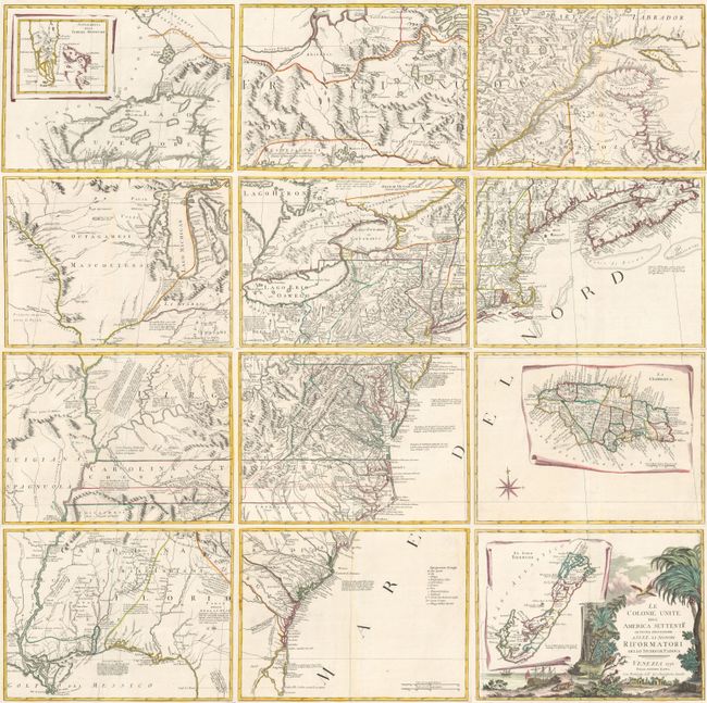
Auction 184, Lot 141
Subject: Colonial Eastern United States & Canada
Zatta, Antonio
[On 12 Sheets] Le Colonie Unite dell' America Settentrle. di Nuova Projezione... , 1778
Size: 16.7 x 12.5 inches (42.4 x 31.8 cm)
Estimate: $4,750 - $6,000
Impressive 12-Sheet Map of the New "United Colonies"
Sold for: $4,500
Closed on 9/15/2021
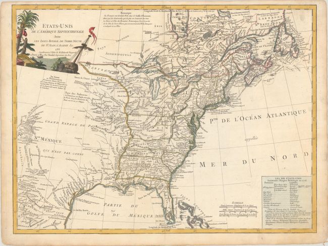
Auction 184, Lot 142
Subject: Eastern United States & Canada
Robert de Vaugondy/Boudet
Etats-Unis de l'Amerique Septentrionale avec les Isles Royale, de Terre Neuve, de St. Jean, l'Acadie &c., 1785
Size: 24.6 x 18.6 inches (62.5 x 47.2 cm)
Estimate: $1,100 - $1,400
First Reference to Michigan as a Land Division of the United States
Sold for: $550
Closed on 9/15/2021
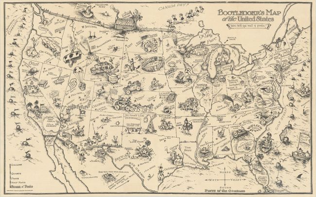
Auction 184, Lot 170
Subject: United States
Bootlegger's Map of the United States, 1926
Size: 33.9 x 21.3 inches (86.1 x 54.1 cm)
Estimate: $1,400 - $1,700
McCandlish's Humorous Prohibition Map
Sold for: $900
Closed on 9/15/2021
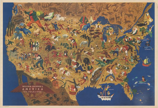
Auction 184, Lot 173
Subject: United States
William Gropper's America Its Folklore, 1946
Size: 32.7 x 22.3 inches (83.1 x 56.6 cm)
Estimate: $1,500 - $1,800
Map by Artist Blacklisted During McCarthy Era
Sold for: $1,700
Closed on 9/15/2021
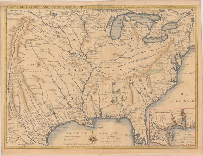
Auction 184, Lot 176
Subject: Colonial Eastern United States
Delisle, Guillaume
Carte de la Louisiane et du Cours du Mississipi Dressee sur un Grand Nombre de Memoires Entrautres sur ceux de Mr. le Maire, 1718
Size: 25.6 x 19.1 inches (65 x 48.5 cm)
Estimate: $5,500 - $7,000
A Foundation Map for the Mississippi Valley and the First Appearance of Texas on a Printed Map - First State
Sold for: $4,000
Closed on 9/15/2021
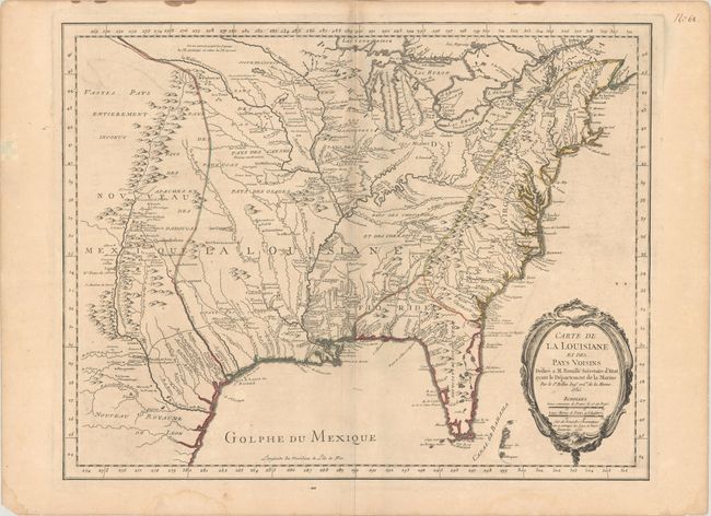
Auction 184, Lot 177
Subject: Colonial Eastern United States
Bellin, Jacques Nicolas
Carte de la Louisiane et des Pays Voisins Dediee a M. Rouille Secretaire d'Etat, Ayant le Departement de la Marine, 1755
Size: 24.1 x 18.8 inches (61.2 x 47.8 cm)
Estimate: $1,400 - $1,700
Bellin's Scarce French and Indian War-Era Map of the Colonial United States
Unsold
Closed on 9/15/2021
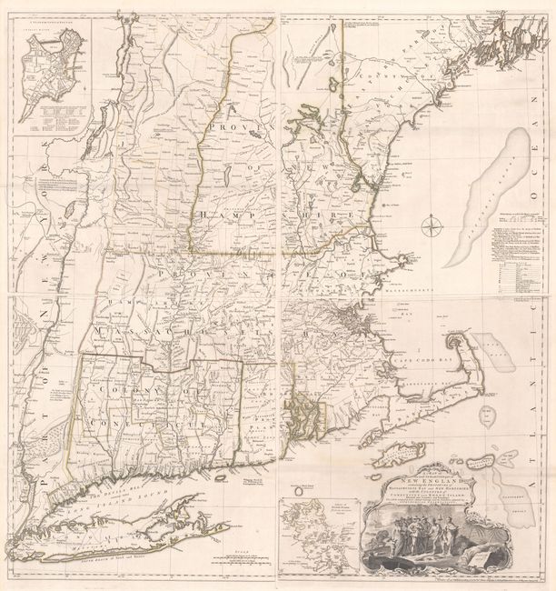
Auction 184, Lot 196
Subject: Colonial New England United States
Jefferys, Thomas
[On 4 Sheets] A Map of the Most Inhabited Part of New England, Containing the Provinces of Massachusets Bay and New Hampshire, with the Colonies of Conecticut and Rhode Island..., 1755
Size: 19.2 x 20.3 inches (48.8 x 51.6 cm)
Estimate: $8,000 - $9,500
Rare State of Jefferys' Influential Map of New England in Contemporary Color
Unsold
Closed on 9/15/2021
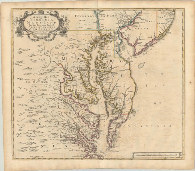
Auction 184, Lot 199
Subject: Colonial Mid-Atlantic United States
Browne/Senex
A New Map of Virginia Mary-land and the Improved Parts of Pennsylvania & New Jersey..., 1719
Size: 22 x 19.2 inches (55.9 x 48.8 cm)
Estimate: $3,000 - $3,750
Map of Chesapeake Bay Based on Landmark Herrman Map
Sold for: $1,900
Closed on 9/15/2021
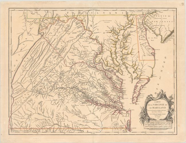
Auction 184, Lot 200
Subject: Colonial Mid-Atlantic United States
Robert de Vaugondy, Didier
Carte de la Virginie et du Maryland Dressee sur la Grande Carte Angloise de Mrs. Josue Fry et Pierre Jefferson, 1755
Size: 25.4 x 19.1 inches (64.5 x 48.5 cm)
Estimate: $2,200 - $2,500
First State of Robert de Vaugondy's Essential Map of Virginia and Maryland
Sold for: $2,300
Closed on 9/15/2021
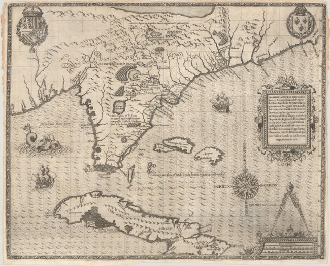
Auction 184, Lot 207
Subject: Colonial Southeast, Florida & Cuba
Bry, Theodore de
Floridae Americae Provinciae Recens & Exactissima Descriptio Auctore Iacobo le Moyne..., 1591
Size: 17.9 x 14.5 inches (45.5 x 36.8 cm)
Estimate: $12,000 - $15,000
De Bry's Influential Map of Colonial North America
Sold for: $9,000
Closed on 9/15/2021
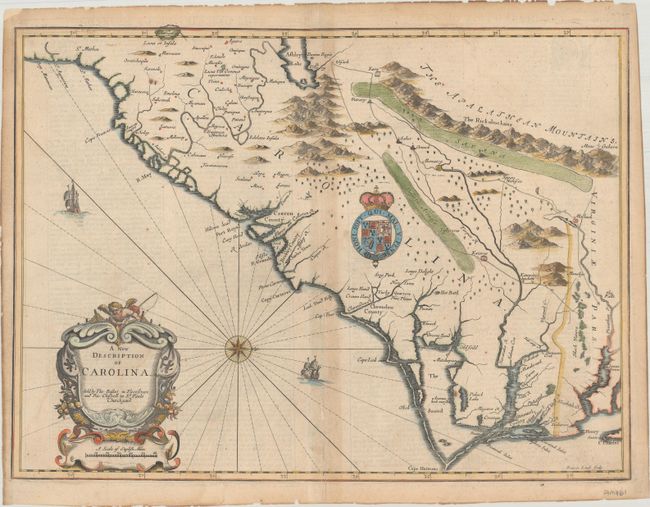
Auction 184, Lot 208
Subject: Colonial Southeast United States
Speed/Lamb
A New Description of Carolina, 1676
Size: 20.1 x 14.9 inches (51.1 x 37.8 cm)
Estimate: $2,400 - $3,000
Speed's Map of the Carolinas Based Upon the Lords Proprietor's Map
Unsold
Closed on 9/15/2021
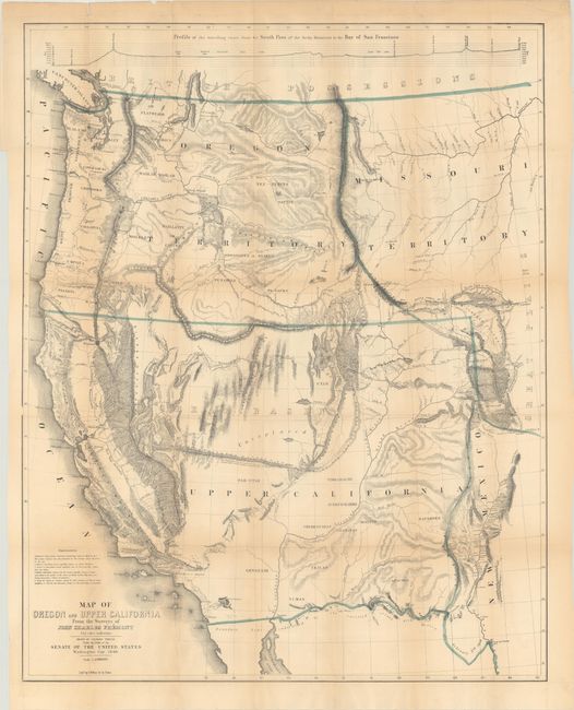
Auction 184, Lot 236
Subject: Western United States
Fremont/Preuss
Map of Oregon and Upper California from the Surveys of John Charles Fremont and Other Authorities [with report] Geographical Memoir upon Upper California..., 1848
Size: 26.5 x 33.1 inches (67.3 x 84.1 cm)
Estimate: $1,400 - $1,700
Fremont's Map of the American West with Report
Sold for: $1,500
Closed on 9/15/2021
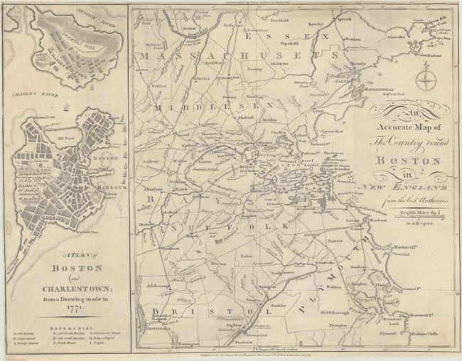
Auction 184, Lot 302
Subject: Boston, Massachusetts
Anon.
An Accurate Map of the Country Round Boston in New England from the Best Authorities [on sheet with] A Plan of Boston and Charlestown; from a Drawing Made in 1771, 1776
Size: 16.3 x 12.5 inches (41.4 x 31.8 cm)
Estimate: $1,200 - $1,500
Scarce Revolutionary War Map
Sold for: $1,200
Closed on 9/15/2021
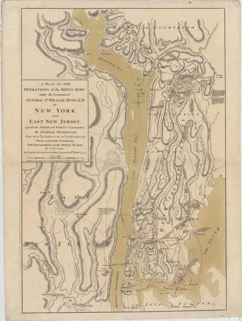
Auction 184, Lot 316
Subject: Colonial New York, Revolutionary War
Sauthier/Faden
A Plan of the Operations of the King's Army Under the Command of General Sr. William Howe, K.B. in New York and East New Jersey, Against the American Forces Commanded by General Washington..., 1777
Size: 19.3 x 28.7 inches (49 x 72.9 cm)
Estimate: $7,000 - $8,500
Important Revolutionary War Map of the Battle of White Plains
Unsold
Closed on 9/15/2021
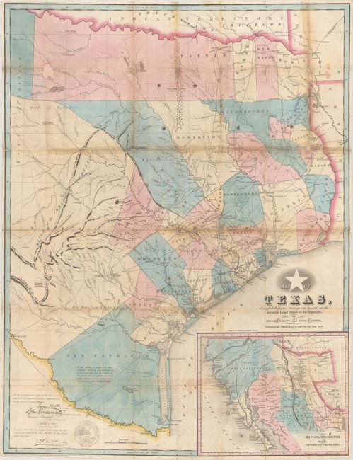
Auction 184, Lot 337
Subject: Republic of Texas
Sherman & Smith
Map of Texas, Compiled from Surveys on Record in the General Land Office of the Republic... [with] A New Guide to Texas..., 1845
Size: 24.2 x 31.5 inches (61.5 x 80 cm)
Estimate: $28,000 - $35,000
Hunt & Randel's Influential Map of the Republic Complete with Guide - Rare 1845 Edition
Sold for: $34,500
Closed on 9/15/2021
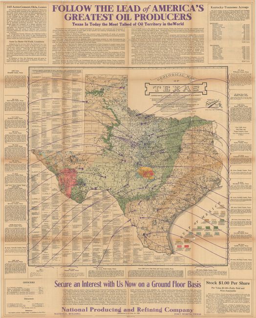
Auction 184, Lot 341
Subject: Texas, Oil Fields
Geological Map of Texas Showing Approximate Locations and Drilling Wells, Also Names of Companies Drilling, 1920
Size: 25.8 x 25.2 inches (65.5 x 64 cm)
Estimate: $300 - $500
Early and Rare Map Promoting Texas Oil
Sold for: $3,250
Closed on 9/15/2021
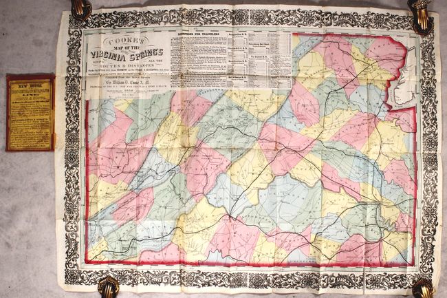
Auction 184, Lot 349
Subject: Virginia
Cooke's Map of the Routes to the Virginia Springs Giving All the Routes & Distances on the VA Central R.R. from Richmond..., 1858
Size: 20.5 x 28 inches (52.1 x 71.1 cm)
Estimate: $5,500 - $7,000
Rare Richmond Imprint Map Promoting Virginia Mineral Springs
Sold for: $3,000
Closed on 9/15/2021
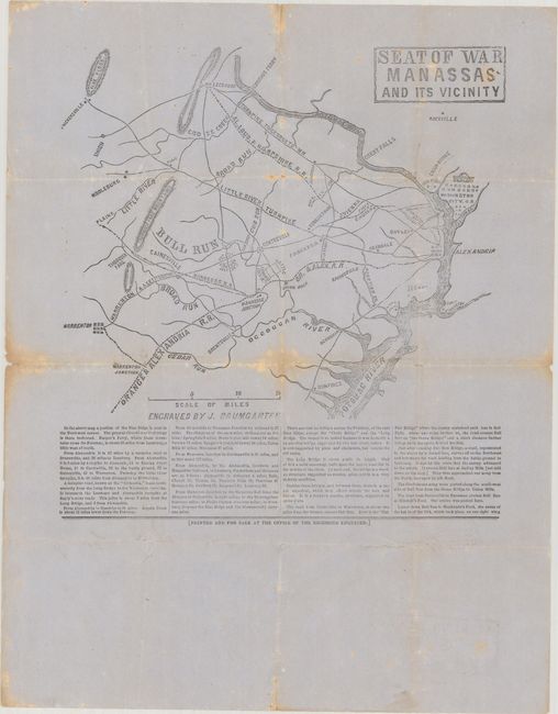
Auction 184, Lot 351
Subject: Northern Virginia, Civil War
Seat of War Manassas and Its Vicinity, 1861
Size: 9.8 x 10.4 inches (24.9 x 26.4 cm)
Estimate: $2,400 - $3,000
Confederate Broadside of the First Major Battle of the Civil War
Unsold
Closed on 9/15/2021
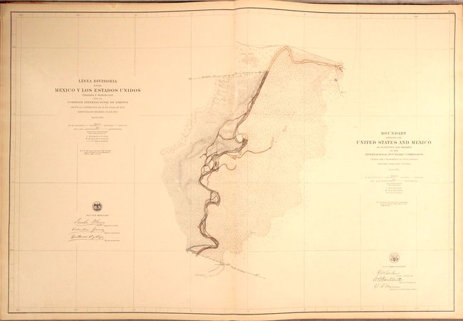
Auction 184, Lot 370
Subject: Southwestern United States & Mexico, Atlas
[2 Volumes] Boundary Between the United States and Mexico, as Surveyed and Marked by the International Boundary Commission... [and] Linea Divisoria Entre Mexico y los Estados Unidos..., 1898
Size: 22 x 29 inches (55.9 x 73.7 cm)
Estimate: $2,400 - $3,000
Mammoth Atlas Volumes from the Mexican Boundary Resurvey
Sold for: $1,600
Closed on 9/15/2021
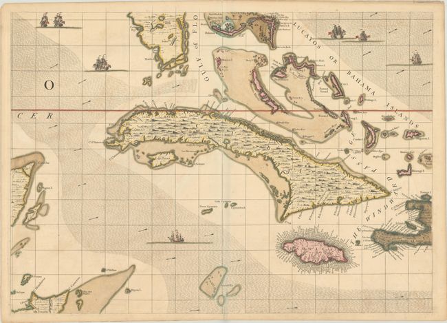
Auction 184, Lot 385
Subject: Greater Antilles
Popple, Henry
[A Map of the British Empire in America (Sheet 14) - Cuba, Bahamas, Jamaica], 1733
Size: 26.9 x 19.3 inches (68.3 x 49 cm)
Estimate: $2,000 - $2,300
Popple Sheet in Full Contemporary Color
Sold for: $1,700
Closed on 9/15/2021
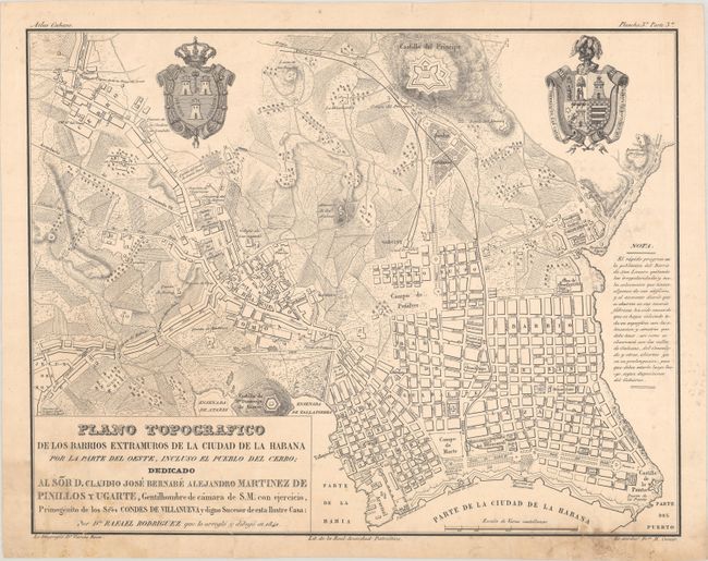
Auction 184, Lot 389
Subject: Havana & Batabano, Cuba
[Lot of 3] Plano Topografico de los Barrios Extramuros de la Ciudad de la Habana... [and] Plano Topografico del Puerto y Bahia de la Habana... [and] Plano Topografico Historico Estadistico del Pueblo del Batabano..., 1841
Size: 20 x 15.6 inches (50.8 x 39.6 cm)
Estimate: $4,000 - $4,750
Three Rare Maps from the First Cuban Atlas Published in Cuba
Sold for: $3,000
Closed on 9/15/2021
Auction 184, Lot 397
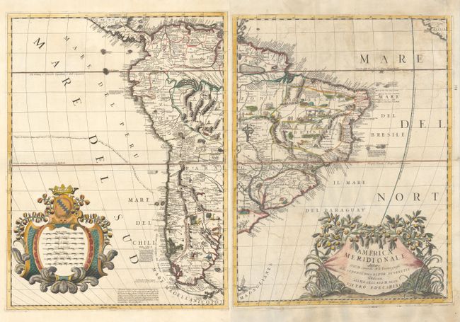
Subject: South America
Coronelli, Vincenzo Maria
[On 2 Sheets] America Meridionale, 1691
Size: 17.8 x 23.4 inches (45.2 x 59.4 cm)
Estimate: $1,500 - $1,800
Coronelli's Influential and Decorative Map of South America
Sold for: $900
Closed on 9/15/2021
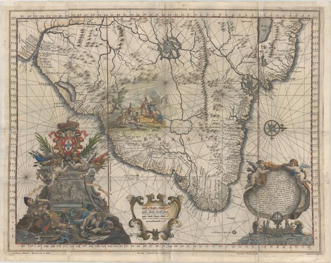
Auction 184, Lot 409
Subject: Brazil
Santa Teresa, J. J. de
Il Regno del Brasile Parte Nobilissima del Mondo Nuovo..., 1698
Size: 22.8 x 17.7 inches (57.9 x 45 cm)
Estimate: $1,500 - $1,800
A Rare Map of Brazil from the Santa Teresa
Sold for: $1,050
Closed on 9/15/2021
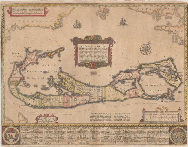
Auction 184, Lot 431
Subject: Bermuda
Speed, John
Mappa Aestivarum Insularum Alias Bermudas Dictarum... / A Mapp of the Sommer Islands Once Called the Bermudas..., 1626
Size: 20.7 x 15.8 inches (52.6 x 40.1 cm)
Estimate: $1,400 - $1,700
Speed's Foundation Map of Bermuda
Sold for: $1,200
Closed on 9/15/2021
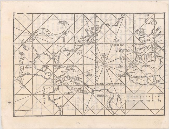
Auction 184, Lot 433
Subject: North Atlantic
De Medina, Pedro
Mundo Novo, 1554
Size: 6.9 x 4.7 inches (17.5 x 11.9 cm)
Estimate: $7,000 - $8,500
Extremely Rare Italian Edition of Medina's Map in Excellent Condition
Sold for: $5,000
Closed on 9/15/2021
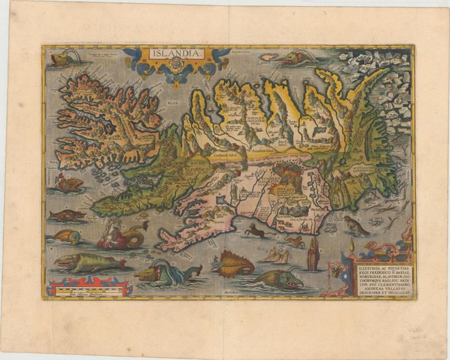
Auction 184, Lot 439
Subject: Iceland
Ortelius, Abraham
Islandia, 1585
Size: 19.3 x 13.3 inches (49 x 33.8 cm)
Estimate: $7,000 - $8,500
One of Ortelius' Most Decorative Maps Featuring Fantastical Sea Monsters
Sold for: $11,000
Closed on 9/15/2021
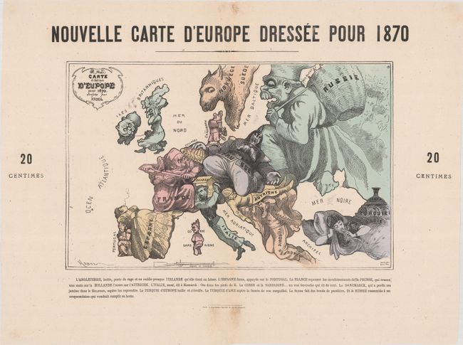
Auction 184, Lot 445
Subject: Europe
Nouvelle Carte d'Europe Dressee pour 1870 / Carte Drolatique d'Europe pour 1870, 1870
Size: 15.1 x 9.6 inches (38.4 x 24.4 cm)
Estimate: $1,400 - $1,700
Satirical Map at the Outset of the Franco-Prussian War
Sold for: $700
Closed on 9/15/2021
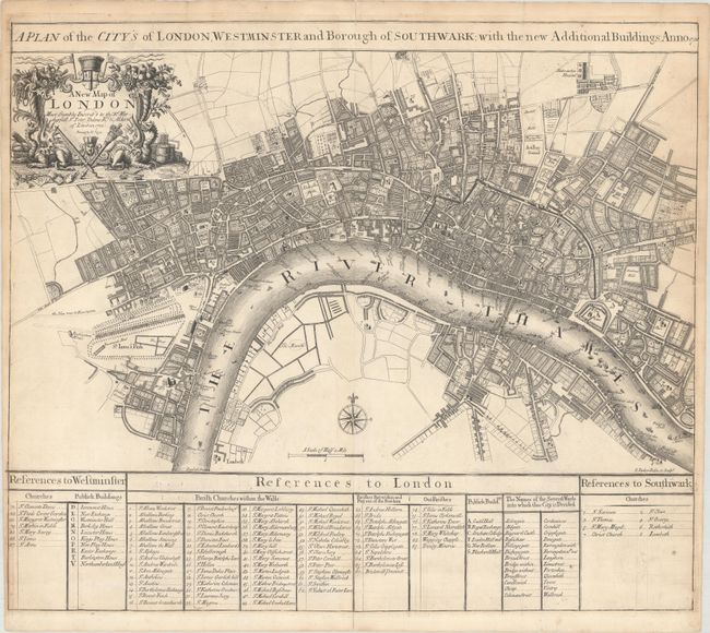
Auction 184, Lot 458
Subject: London, England
Senex, John
A New Map of London Most Humbly Inscrib'd to the Rt. Worshipfull Sr. Peter Delme Kt. & Aldermn of London, 1720
Size: 22.9 x 19.7 inches (58.2 x 50 cm)
Estimate: $1,600 - $1,900
Scarce Plan of London Published in the Only Edition of Senex's New General Atlas
Sold for: $1,100
Closed on 9/15/2021
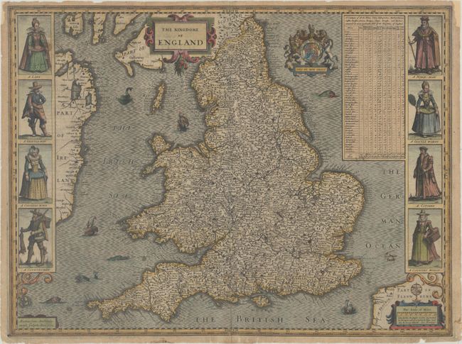
Auction 184, Lot 463
Subject: England & Wales
Speed, John
The Kingdome of England, 1632
Size: 20.3 x 15.2 inches (51.6 x 38.6 cm)
Estimate: $1,800 - $2,200
Speed's Carte-a-Figures Map of England and Wales
Sold for: $900
Closed on 9/15/2021
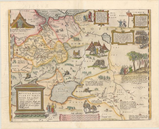
Auction 184, Lot 542
Subject: Russia, Eastern Europe & Central Asia
Ortelius, Abraham
Russiae, Moscoviae et Tartariae Descriptio. Auctore Antonio Ienkensono Anglo..., 1584
Size: 17.8 x 13.9 inches (45.2 x 35.3 cm)
Estimate: $1,600 - $1,900
Ortelius' Map of Russia with a Vignette of Ivan the Terrible
Sold for: $1,300
Closed on 9/15/2021
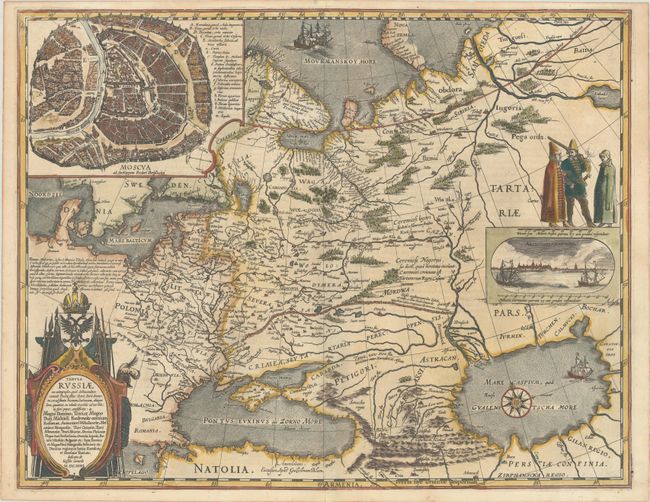
Auction 184, Lot 544
Subject: Russia in Europe
Blaeu, (Family)
Tabula Russiae ex Autographo, quod Delineandum Curavit Foedor Filius Tzaris Boris Desumta ... M.DC.XIIII, 1643
Size: 21.5 x 16.8 inches (54.6 x 42.7 cm)
Estimate: $1,800 - $2,100
Blaeu's Decorative Map of Russia
Sold for: $1,300
Closed on 9/15/2021
77 lots
Page 1 of 2