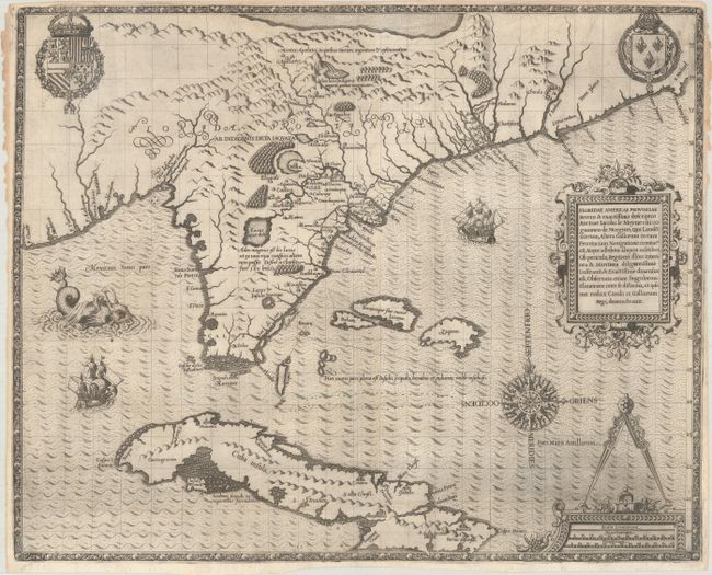
Subject: Colonial Southeast, Florida & Cuba
Period: 1591 (circa)
Publication: Grand Voyages, Part II
Color: Black & White
Size:
17.9 x 14.5 inches
45.5 x 36.8 cm
This copper engraving is from a remarkable series of publications, illustrating voyages of discovery and travels of exploration to various parts of the world. The project was begun by Theodore de Bry of Frankfurt, in 1590 and was to continue for another 54 years. They became known collectively as the Grands Voyages (to America and the West Indies) and the Petits Voyages (to the Orient and the East Indies). De Bry died after the first six parts of the Grands Voyages were completed. The project was completed initially by his widow and two sons, Johann Theodore de Bry and Johann Israel de Bry, then by Johann Theodore's son-in-law, Matthaus Merian, in 1624.
This is one of the most influential maps of colonial North America. De Bry purchased Jacques le Moyne's map from his widow to illustrate the early French colonial attempts in the region. Le Moyne accompanied the second expedition to Florida in 1564 where he recorded and mapped the region. The small settlement and Fort Carolina on St. John's River (called River May by the French) was destroyed by the Spanish and Le Moyne narrowly escaped. He made his way to London where he settled. Despite the fact that his map is not very accurate it was extremely influential; partially because Hondius copied it and included it in his editions of the Mercator Atlas, which had wide circulation and popularity. The map's inaccuracy is mainly in the longitude, which resulted in an extended eastward slant to the Atlantic coastline. Most of the information presented was derived from Indian sources including several spurious lakes. Many of these features were copied by subsequent cartographers for over 150 years. The large body of water at top is variously thought to be a representation of the Sea of Verrazzano (thought at the time to connect to the Pacific and provide a route to Asia) or the Great Lakes. The waterfall nearby is thought to be derived from Indian tales of Niagara Falls. The map is richly adorned with a superb compass rose, two fine cartouches, sailing ships, a fanciful sea monster, and the royal arms of Spain's Phillip II and France's Charles IX.
References: Burden #79; Cumming #14; Garratt (TMC) #G2; Pritchard & Taliaferro #3.
Condition: A
A dark impression, issued folding and now flattened on a bright sheet with minor extraneous creasing and narrow margins, as is commonly found with this map.