Catalog Archive
Auction 184, Lot 341

Early and Rare Map Promoting Texas Oil

"Geological Map of Texas Showing Approximate Locations and Drilling Wells, Also Names of Companies Drilling",

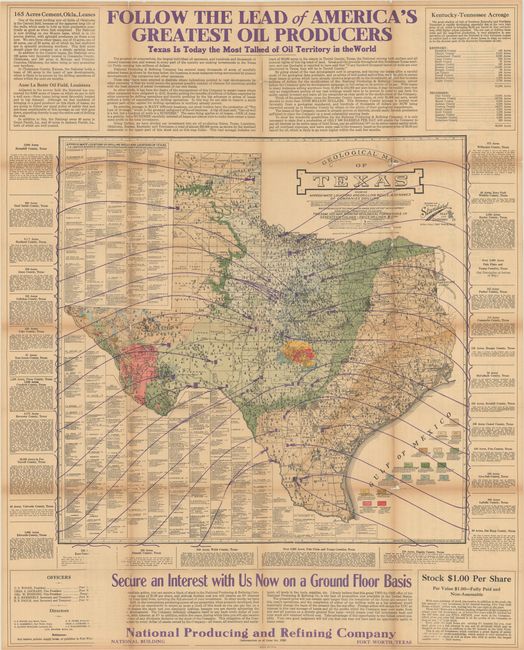
Subject: Texas, Oil Fields

Period: 1920 (dated)

Publication:

Color: Printed Color

Size:
25.8 x 25.2 inches
65.5 x 64 cm
Download High Resolution Image
(or just click on image to launch the Zoom viewer)

This large map focuses on the burgeoning oil and gas business in Texas, with surrounding text promoting the properties of the National Producing and Refining Company of Fort Worth. The banner above the map reads "Follow The Lead Of America’s Greatest Oil Producers/ Texas Is Today The Most Talked About Oil Territory In The World." The detailed geological map locates a huge number of Drilling Wild Cats (wells), each shown by individual, small oil derricks. A wide pallet of colors and texture indicate seventeen different geological types, with the oil and gas fields located and railroads delineated. A large table, occupying most of the left side, lists all of the oil drilling activity fields by county and drilling company keyed to the map. The verso has two large full pages of promotions under a headline: Secure an Interest in the Oil Profits of Texas/ Texas Produces 70,000,000 Barrels of Crude in 1919. Copyrighted in May 1920 by the Standard, Blue Print, Map & Engineering Company of Fort Worth. The full sheet with surrounding text measures 31.5 x 39.4".

This is a larger version of a map we listed in 2011 (click here for details).

References:

Condition: B

Issued folding on thin paper with light toning and numerous small splits and tears along the folds that have been partially closed on verso with archival tape. There is small loss at several fold junctions.

Estimate: $300 - $500

Sold for: $3,250

Closed on 9/15/2021

Archived