Showing Featured Lots(remove filter)
Showing results for:Auction 146
Catalog Archive
87 lots
Page 1 of 2
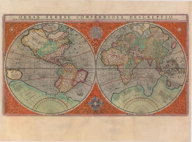
Auction 146, Lot 15
Subject: World
Mercator, Rumold
Orbis Terrae Compendiosa Descriptio…, 1587
Size: 20.7 x 11.4 inches (52.6 x 29 cm)
Estimate: $5,000 - $6,500
Mercator's Double-Hemisphere World Map
Unsold
Closed on 9/4/2013
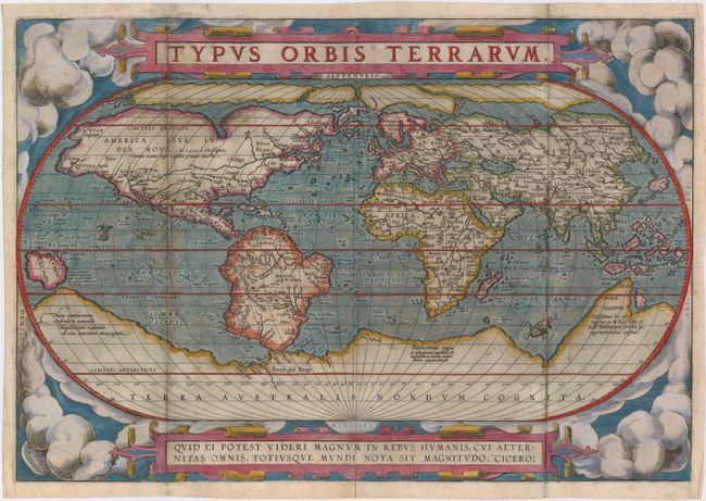
Auction 146, Lot 16
Subject: World
Ortelius, Abraham
Typus Orbis Terrarum, 1587
Size: 18.9 x 12.8 inches (48 x 32.5 cm)
Estimate: $7,000 - $9,000
Rare Second Plate of Ortelius' World Map
Sold for: $4,750
Closed on 9/4/2013
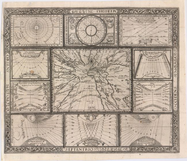
Auction 146, Lot 18
Subject: World
Ritter, Franz
[Untitled - World and Horological Diagrams], 1607
Size: 13.4 x 11.2 inches (34 x 28.4 cm)
Estimate: $3,000 - $3,750
Ritter's Unusual Sun-Dial World Map - First State
Unsold
Closed on 9/4/2013
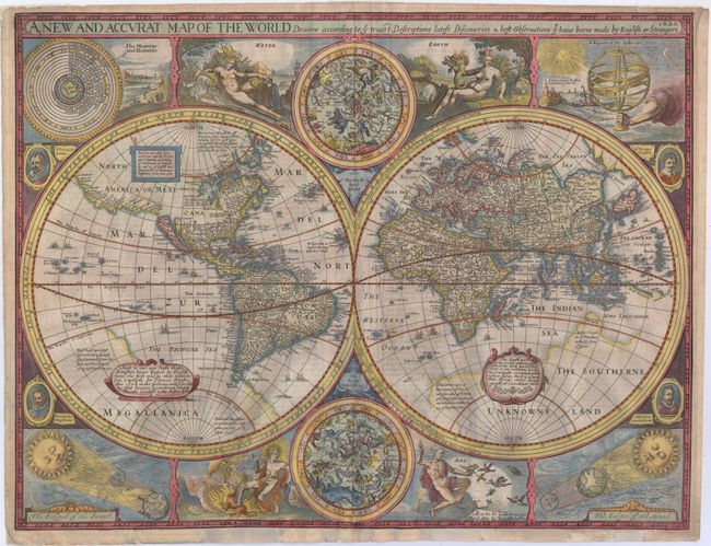
Auction 146, Lot 21
Subject: World
Speed, John
A New and Accurat Map of the World Drawne According to ye Truest Descriptions Latest Discoveries & Best Observations yt have beene Made by English or Strangers, 1626
Size: 20.5 x 15.8 inches (52.1 x 40.1 cm)
Estimate: $12,000 - $14,000
Speed's Double-Hemisphere World Map
Sold for: $12,500
Closed on 9/4/2013
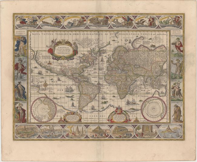
Auction 146, Lot 22
Subject: World
Blaeu, Willem
Nova Totius Terrarum Orbis Geographica ac Hydrographica Tabula, 1640
Size: 21.6 x 16.1 inches (54.9 x 40.9 cm)
Estimate: $13,000 - $15,000
Blaeu's Magnificent Carte-a-Figures World Map
Sold for: $8,000
Closed on 9/4/2013
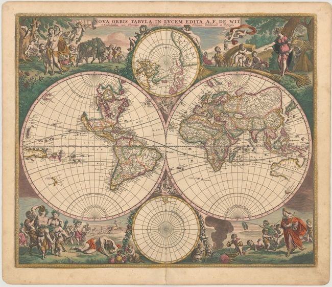
Auction 146, Lot 24
Subject: World
Wit, Frederick de
Nova Orbis Tabula, in Lucem Edita, 1688
Size: 22.3 x 18.8 inches (56.6 x 47.8 cm)
Estimate: $5,500 - $7,000
De Wit's Stunning Double-Hemisphere Map in Full Original Color
Sold for: $3,750
Closed on 9/4/2013
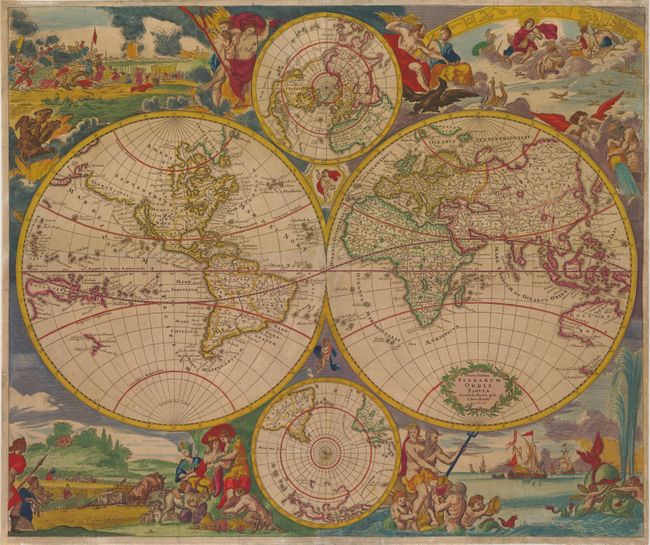
Auction 146, Lot 25
Subject: World
Danckerts, Justus
Nova Totius Terrarum Orbis Tabula Amstelodami per I. Danckerts cum Privil., 1685
Size: 23 x 19.3 inches (58.4 x 49 cm)
Estimate: $4,000 - $4,750
Sold for: $2,500
Closed on 9/4/2013
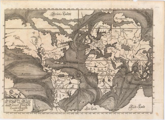
Auction 146, Lot 28
Subject: World
Happel, Everard Werner
Die Ebbe und Fluth auff einer Flachen Landt-Karten Furgestelt, 1687
Size: 11.4 x 8 inches (29 x 20.3 cm)
Estimate: $1,200 - $1,500
One of the Earliest Thematic World Maps
Unsold
Closed on 9/4/2013
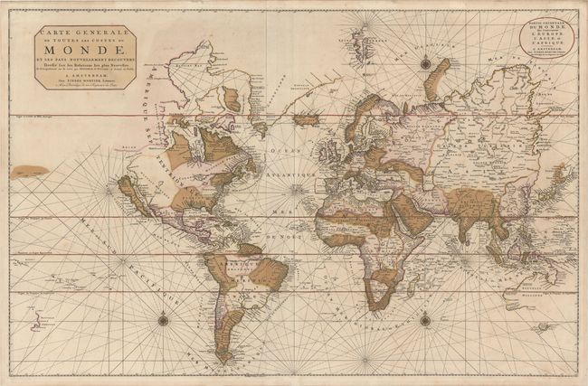
Auction 146, Lot 29
Subject: World
Mortier, Pierre
Carte Generale de Toutes les Costes du Monde, et les Pays Nouvellement Decouvert, Dressee sur les Relations les Plus Nouvelles..., 1700
Size: 35.6 x 23.1 inches (90.4 x 58.7 cm)
Estimate: $4,500 - $5,500
Large-Scale World Map with California as and Island and Interesting Great Lakes Formation
Unsold
Closed on 9/4/2013
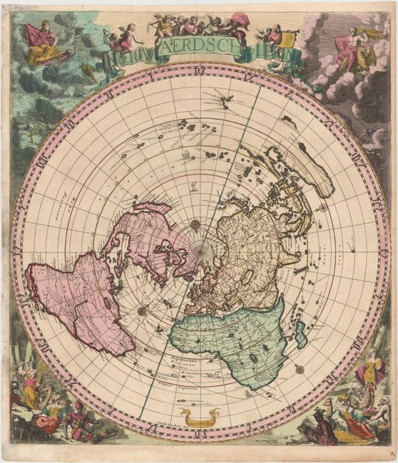
Auction 146, Lot 30
Subject: World
Robijn (Robyn), Jacobus
Nieuw Aerdsch Pleyn, 1700
Size: 20.5 x 23.3 inches (52.1 x 59.2 cm)
Estimate: $6,000 - $7,500
Rare World Map on a Singular Polar Projection
Sold for: $3,500
Closed on 9/4/2013
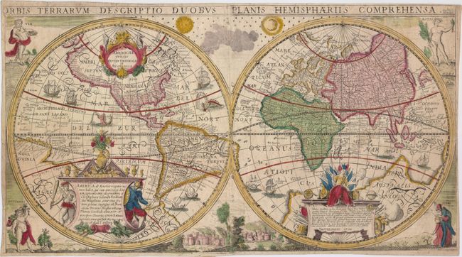
Auction 146, Lot 37
Subject: World
Anon.
Orbis Terrarum Descriptio Duobus Planis Hemisphaeriis Comprehensa, 1750
Size: 21.9 x 12 inches (55.6 x 30.5 cm)
Estimate: $3,750 - $4,500
Scarce, Decorative Double-Hemisphere World Map Based on Geelkercken and Hondius
Unsold
Closed on 9/4/2013
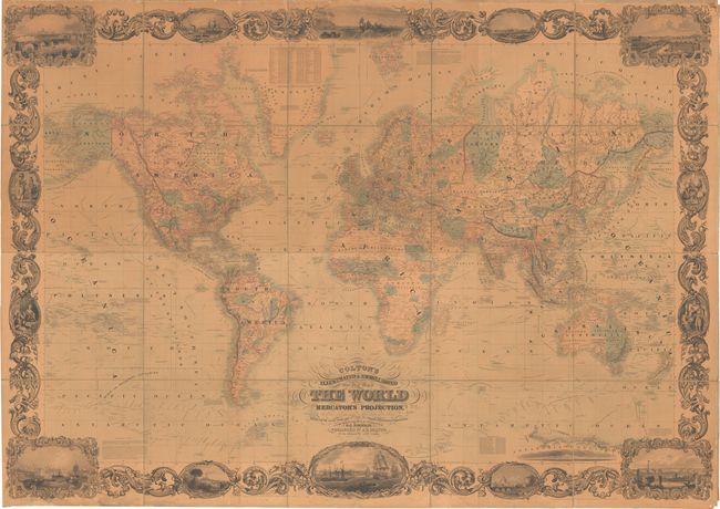
Auction 146, Lot 47
Subject: World
Colton, Joseph Hutchins
Colton's Illustrated & Embellished Steel Plate Map of the World on Mercator's Projection Compiled from the Latest & Most Authentic Sources…, 1854
Size: 77.5 x 55 inches (196.9 x 139.7 cm)
Estimate: $8,000 - $10,000
Unsold
Closed on 9/4/2013
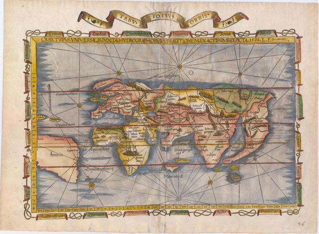
Auction 146, Lot 49
Subject: Ancient World
Fries, Lorenz
Orbis Typus Universalis Iuxta Hydrographorum Traditionem Exactissime Depicta, 1522
Size: 18.8 x 13.8 inches (47.8 x 35.1 cm)
Estimate: $6,000 - $7,500
Sold for: $4,500
Closed on 9/4/2013
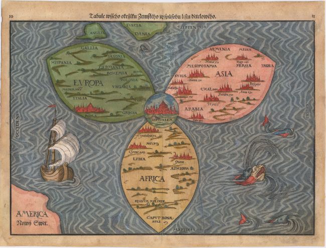
Auction 146, Lot 50
Subject: Ancient World
Bunting, Heinrich
Tabule Wsseho Ofrsslku Zemskeho W Spusobu Listu Detelowelo, 1592
Size: 14.3 x 10.5 inches (36.3 x 26.7 cm)
Estimate: $6,000 - $7,500
Rare Edition of Bunting's Clover Leaf Map of the Old World
Sold for: $4,500
Closed on 9/4/2013
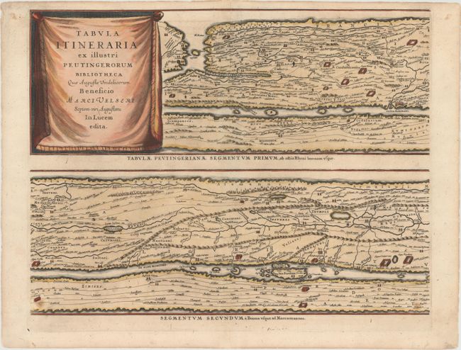
Auction 146, Lot 53
Subject: Ancient World
Jansson, Jan
[On 4 Sheets] Tabula Itineraria ex Illustri Peutingerorum Bibliotheca quae Augustae Vindelicorum Beneficio…, 1650
Size: 20.3 x 15.4 inches (51.6 x 39.1 cm)
Estimate: $3,500 - $4,250
Sold for: $2,750
Closed on 9/4/2013
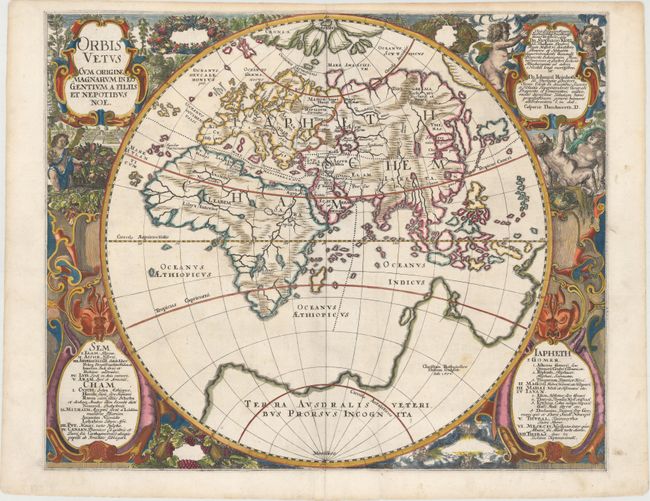
Auction 146, Lot 54
Subject: Ancient World
Danckwerth, Casper
Orbis Vetus Cum Origine Magnarum in eo Gentium A Filiis et Nepotibus Noe, 1651
Size: 21 x 17 inches (53.3 x 43.2 cm)
Estimate: $1,300 - $1,500
Sold for: $800
Closed on 9/4/2013
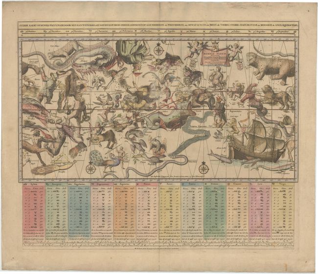
Auction 146, Lot 69
Subject: Celestial
Ottens, Reiner and Joshua
Sterre Kaert of Hemels Pleyn, Waer door men Kan Wete Hoe Laet..., 1756
Size: 22.8 x 18.5 inches (57.9 x 47 cm)
Estimate: $2,000 - $2,200
Unsold
Closed on 9/4/2013
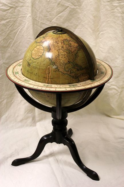
Auction 146, Lot 73
Subject: Globes
Cary, John
[12 Inch Globe] Cary’s New Terrestrial Globe Delineated from the Best Authorities…, 1800
Size: 17 x 24 inches (43.2 x 61 cm)
Estimate: $10,000 - $12,000
Magnificent Early Cary Brothers Globe
Unsold
Closed on 9/4/2013
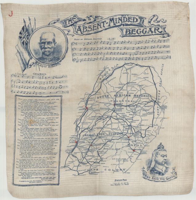
Auction 146, Lot 78
Subject: Cartographic Miscellany
[Map of South Africa] The Absent-Minded Beggar, 1900
Size: 17.7 x 18 inches (45 x 45.7 cm)
Estimate: $150 - $200
Sold for: $160
Closed on 9/4/2013
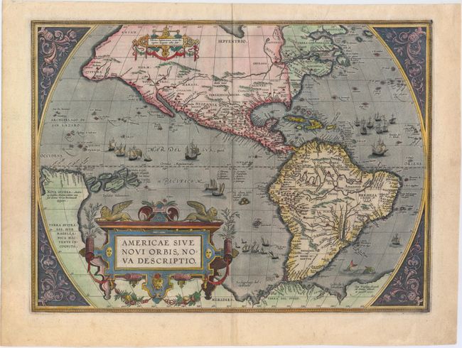
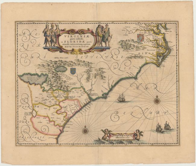
Auction 146, Lot 79
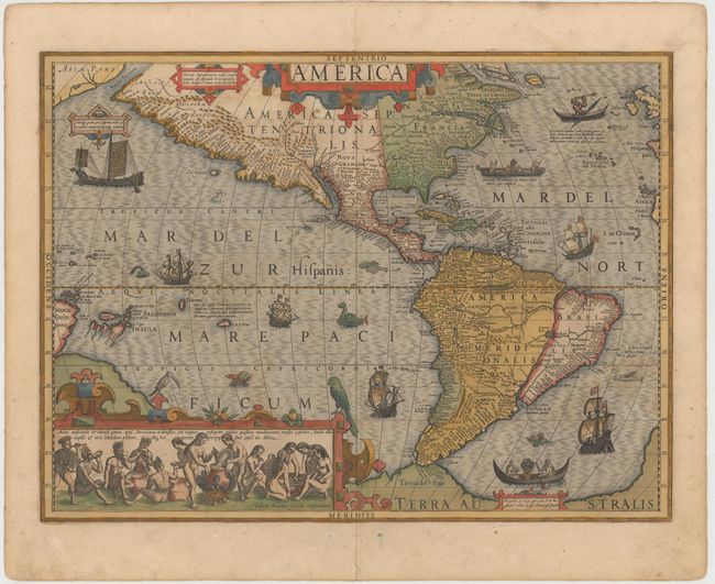
Subject: Western Hemisphere - America
Ortelius, Abraham
Americae sive Novi Orbis, Nova Descriptio, 1587
Size: 19.2 x 14 inches (48.8 x 35.6 cm)
Estimate: $6,000 - $7,500
Ortelius' Influential Map of the New World
Sold for: $4,500
Closed on 9/4/2013
Auction 146, Lot 81
Subject: Western Hemisphere - America
Hondius, Jodocus
America, 1619
Size: 19.7 x 14.7 inches (50 x 37.3 cm)
Estimate: $4,750 - $6,000
Hondius' Important Map of the Americas
Sold for: $4,250
Closed on 9/4/2013
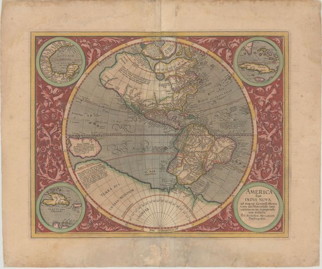
Auction 146, Lot 82
Subject: Western Hemisphere - America
Mercator, Michael
America sive India Nova ad Magnae Gerardi Mercatoris aui Universalis Imitationem in Compendium Redacta, 1633
Size: 18 x 14.5 inches (45.7 x 36.8 cm)
Estimate: $4,250 - $5,500
Unsold
Closed on 9/4/2013
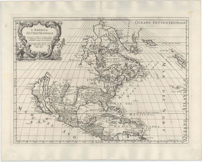
Auction 146, Lot 97
Subject: North America
Rossi, Giamcomo Giovanni
L'America Settentrionale, 1687
Size: 21.5 x 15.5 inches (54.6 x 39.4 cm)
Estimate: $2,300 - $2,750
Sold for: $1,300
Closed on 9/4/2013
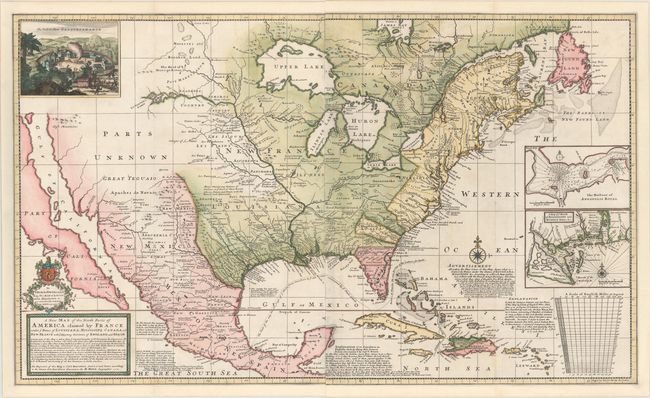
Auction 146, Lot 98
Subject: North America
Moll, Herman
A New Map of the North Parts of America Claimed by France under ye Names of Louisiana, Mississipi, Canada and New France with ye Adjoyning Territories of England and Spain, 1720
Size: 39.8 x 24.3 inches (101.1 x 61.7 cm)
Estimate: $5,500 - $7,000
First State of Moll's Map of North America
Sold for: $4,750
Closed on 9/4/2013
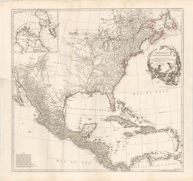
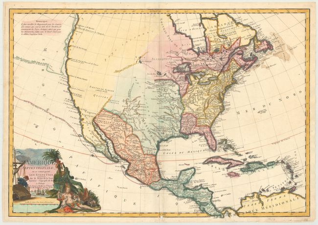
Auction 146, Lot 100
Subject: North America
Anville, Jean Baptiste Bourguignon d'
Amerique Septentrionale Publiee sous les Auspices de Monseigneur le Duc d'Orleans..., 1746
Size: 34.1 x 32.7 inches (86.6 x 83.1 cm)
Estimate: $1,900 - $2,200
Unsold
Closed on 9/4/2013
Auction 146, Lot 102
Subject: North America
Brion de la Tour, Louis
L'Amerique Septentrionale, ou se Remarquent les Etats Unis, 1783
Size: 28.8 x 20 inches (73.2 x 50.8 cm)
Estimate: $2,000 - $2,500
One of the Earliest Maps to Acknowledge the United States in the Title
Unsold
Closed on 9/4/2013
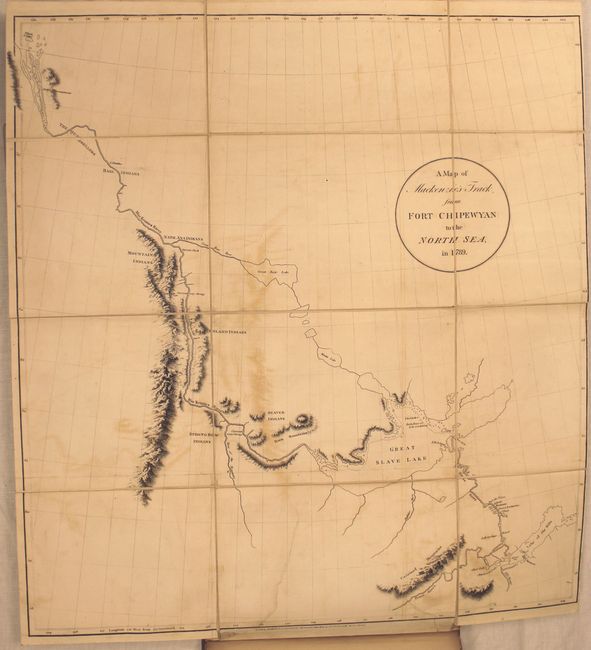
Auction 146, Lot 116
Subject: Canada
Mackenzie, Alexander
Voyages from Montreal, on the River St. Laurence, Through the Continent of North America, to the Frozen and Pacific Oceans; in the Years 1789 and 1793..., 1801
Size: 8.6 x 10.8 inches (21.8 x 27.4 cm)
Estimate: $6,000 - $7,000
First Edition of Mackenzie's Famous Account
Unsold
Closed on 9/4/2013
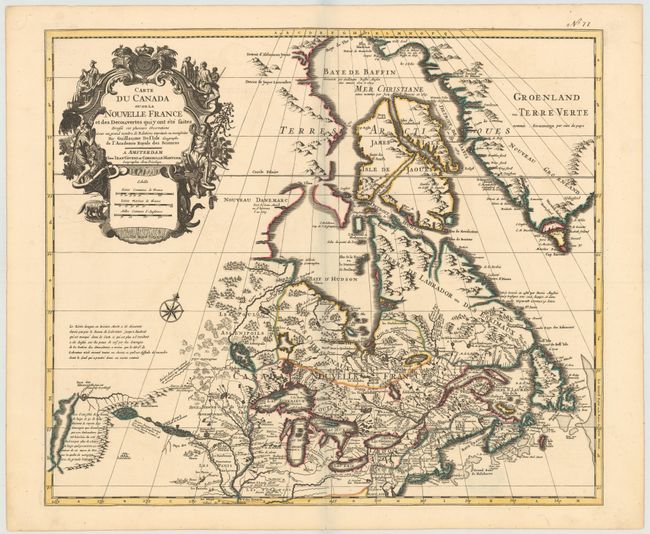
Auction 146, Lot 121
Subject: Colonial United States & Canada
Delisle/Covens & Mortier
Carte du Canada ou de la Nouvelle France et des Decouvertes quiy ont ete Faites..., 1730
Size: 22.6 x 19.3 inches (57.4 x 49 cm)
Estimate: $1,400 - $1,700
One of the most influential maps of Canada, the Great Lakes and Upper Midwest
Sold for: $1,300
Closed on 9/4/2013
Auction 146, Lot 150
Subject: Eastern United States
Brion de la Tour, Louis
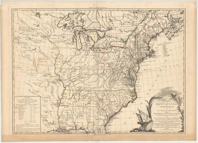
Carte des Etats-Unis d'Amerique et du Cours du Mississipi…, 1784
Size: 27.5 x 20 inches (69.9 x 50.8 cm)
Estimate: $3,000 - $3,750
One of the Earliest Maps of the New United States
Unsold
Closed on 9/4/2013
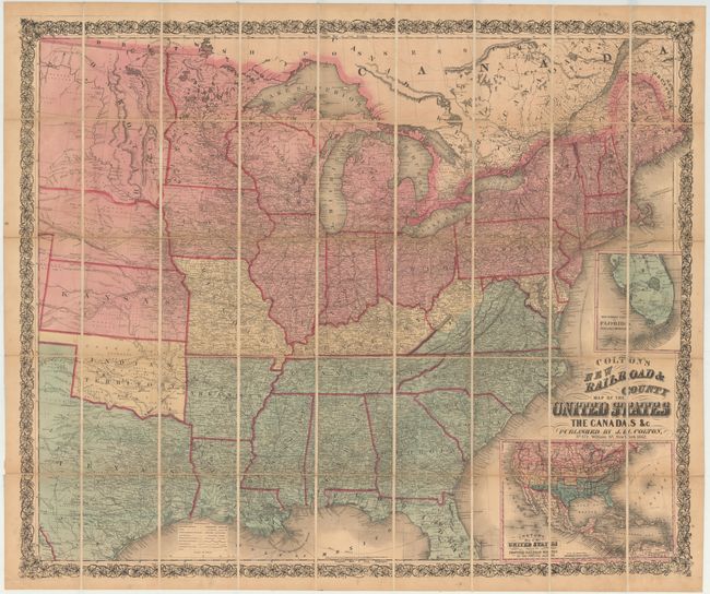
Auction 146, Lot 157
Subject: Eastern United States
Colton, Joseph Hutchins
Colton's New Railroad & County Map of the United States, 1862
Size: 39.5 x 33 inches (100.3 x 83.8 cm)
Estimate: $1,100 - $1,300
Rare Colton Civil War Map for a British Audience
Sold for: $700
Closed on 9/4/2013
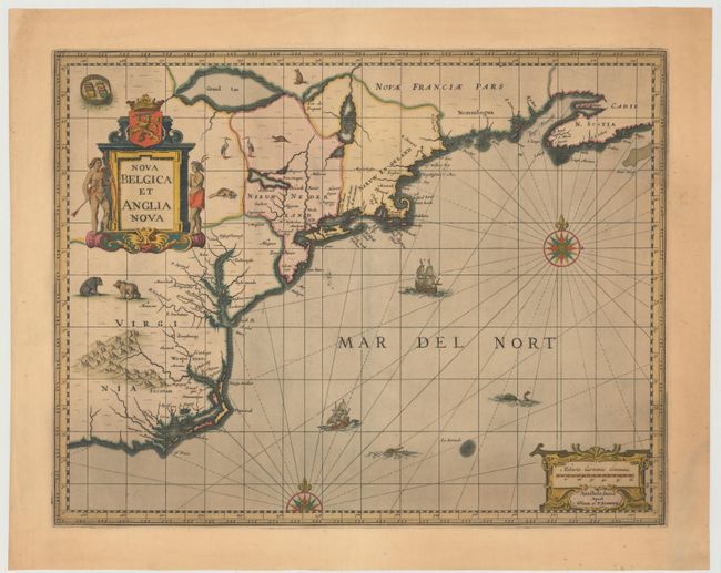
Auction 146, Lot 159
Subject: Colonial New England & Mid-Atlantic United States
Jansson/Valck & Schenk
Nova Belgica et Anglia Nova, 1694
Size: 19.5 x 15 inches (49.5 x 38.1 cm)
Estimate: $2,100 - $2,400
Jansson's Influential Map of the East Coast
Unsold
Closed on 9/4/2013
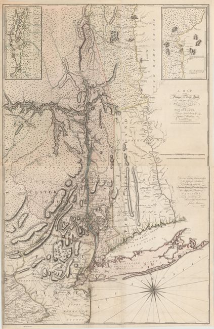
Auction 146, Lot 161
Subject: Colonial New England & Mid-Atlantic
Montresor, John
[On 2 Sheets] A Map of the Province of New York, with Part of Pensilvania, and New England..., 1775
Size: 36.2 x 28.5 inches (91.9 x 72.4 cm)
Estimate: $9,000 - $11,000
An Important Revolutionary War Period Map
Sold for: $5,500
Closed on 9/4/2013
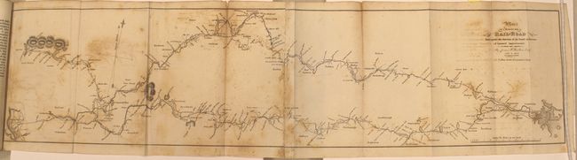
Auction 146, Lot 162
Subject: New England, Railroads
Report of the Board of Directors of Internal Improvements of the State of Massachusetts on the Practicability and Expediency of a Rail-Road from Boston to the Hudson River..., 1829
Size: 5.7 x 9.1 inches (14.5 x 23.1 cm)
Estimate: $800 - $1,000
Sold for: $500
Closed on 9/4/2013
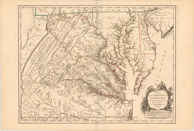
Auction 146, Lot 164
Subject: Colonial Mid-Atlantic United States, Virginia & Maryland
Robert de Vaugondy, Didier
Carte de la Virginie et du Maryland Dressee sur la Grande Carte Angloise de Mrs. Josue Fry et Pierre Jefferson, 1755
Size: 25.2 x 19.1 inches (64 x 48.5 cm)
Estimate: $3,250 - $4,000
An Essential Map of Virginia and Maryland
Sold for: $2,750
Closed on 9/4/2013
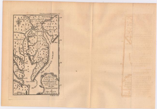
Auction 146, Lot 165
Subject: Colonial Mid-Atlantic United States
Mynde, James
A Map of That Part of America Where a Degree of Latitude Was Measured for the Royal Society by Cha: Mason & Jere: Dixon, 1769
Size: 3.9 x 6.6 inches (9.9 x 16.8 cm)
Estimate: $500 - $650
Rare First Issue of the Mason-Dixon Survey
Sold for: $850
Closed on 9/4/2013
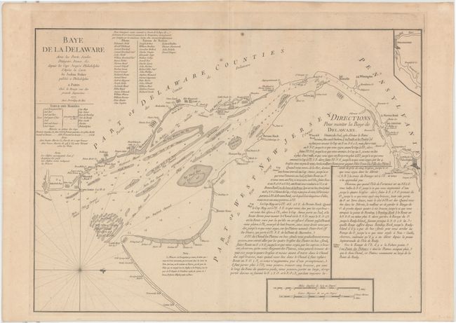
Auction 146, Lot 166
Subject: Colonial Mid-Atlantic, Delaware Bay
Le Rouge, George Louis
Baye de la Delaware avec les Ports, Sondes, Dangers, Bancs &c. depuis les Caps Jusqu'a Philadelphie…, 1777
Size: 25.8 x 19 inches (65.5 x 48.3 cm)
Estimate: $1,800 - $2,200
The Most Accurate Chart of Delaware Bay in the 18th Century
Unsold
Closed on 9/4/2013
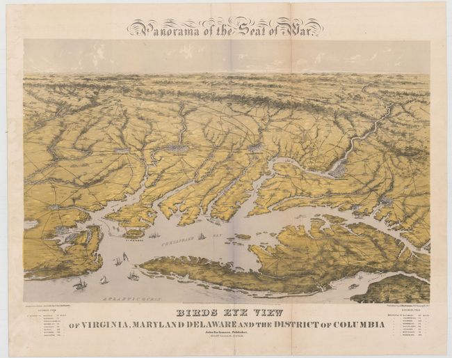
Auction 146, Lot 170
Subject: Mid-Atlantic, Civil War
Bachmann, John
Panorama of the Seat of War, Birds Eye View of Virginia, Maryland, Delaware, and the District of Columbia, 1861
Size: 27.8 x 18 inches (70.6 x 45.7 cm)
Estimate: $2,000 - $2,300
Sold for: $1,900
Closed on 9/4/2013
Auction 146, Lot 171
Subject: Colonial Southeast
Jansson, Jan
Virginiae Partis Australis, et Floridae Partis Orientalis, Interjacentiumque Regionum Nova Descriptio, 1647
Size: 19.8 x 15.2 inches (50.3 x 38.6 cm)
Estimate: $1,500 - $1,800
Unsold
Closed on 9/4/2013
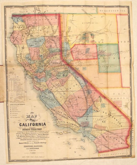
Auction 146, Lot 189
Subject: California, Nevada
Ransom & Doolittle
A New Map of the State of California and Nevada Territory..., 1863
Size: 21.5 x 26.3 inches (54.6 x 66.8 cm)
Estimate: $4,750 - $6,000
Early and Important Map of the Western Mining Districts
Unsold
Closed on 9/4/2013
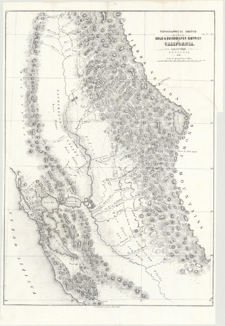
Auction 146, Lot 195
Subject: California
Ord, E. O. C.
Topographical Sketch of the Gold & Quicksilver District of California, 1848
Size: 15.5 x 21.5 inches (39.4 x 54.6 cm)
Estimate: $400 - $500
Sold for: $550
Closed on 9/4/2013
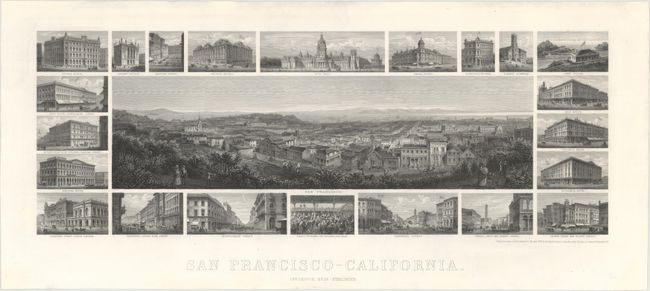
Auction 146, Lot 206
Subject: San Francisco, California
San Francisco - California, 1874
Size: 24.7 x 10.8 inches (62.7 x 27.4 cm)
Estimate: $4,000 - $5,000
Sold for: $2,600
Closed on 9/4/2013
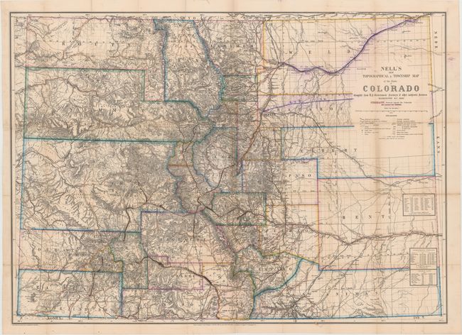
Auction 146, Lot 212
Subject: Colorado
Nell, Louis
Nell's New Topographical & Township Map of the State of Colorado…, 1880
Size: 37.8 x 27.5 inches (96 x 69.9 cm)
Estimate: $3,250 - $4,000
Louis Nell's First Edition Map of Colorado
Unsold
Closed on 9/4/2013
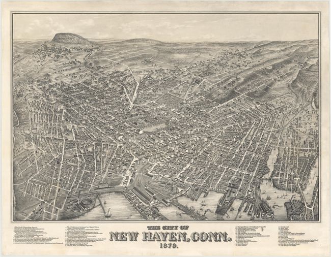
Auction 146, Lot 213
Subject: New Haven, Connecticut
Bailey, O. H. & Co.
The City of New Haven, Conn. 1879., 1879
Size: 37.4 x 25.7 inches (95 x 65.3 cm)
Estimate: $8,000 - $10,000
Extremely Rare View of New Haven and Yale College
Unsold
Closed on 9/4/2013
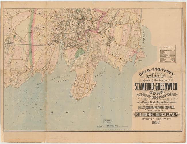
Auction 146, Lot 214
Subject: Southwest Connecticut
[On 3 of 4 Sheets] Road and Property Map Showing the Towns of Stamford and Greenwich Conn. Together with Surrounding Territory…, 1890
Size: 35.2 x 24.3 inches (89.4 x 61.7 cm)
Estimate: $1,600 - $1,900
Unsold
Closed on 9/4/2013
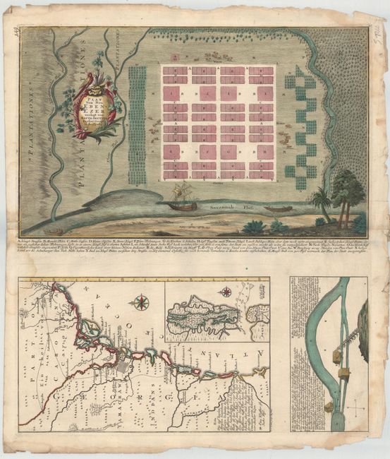
Auction 146, Lot 220
Subject: Georgia
Seutter, Matthias
Plan von Neu Ebenezer [on sheet with] [Untitled - Map of Southeast], 1747
Size: 19.8 x 12 inches (50.3 x 30.5 cm)
Estimate: $7,000 - $8,500
Rare Plan of Georgia Settlement New Ebenezer
Unsold
Closed on 9/4/2013
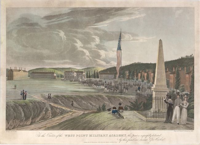
Auction 146, Lot 241
Subject: West Point Military Academy, New York
Catlin, George
[Looking South - Artillery Drill] To the Cadets of the West Point Military Academy This Print Is Respectfully Dedicated by Their Friend and Servant Geo. Catlin, 1828
Size: 18.3 x 13.2 inches (46.5 x 33.5 cm)
Estimate: $2,750 - $3,500
Sold for: $2,000
Closed on 9/4/2013
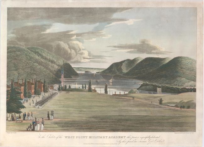
Auction 146, Lot 242
Subject: West Point Military Academy, New York
Catlin, George
[Looking North - Military Drill] To the Cadets of the West Point Military Academy This Print Is Respectfully Dedicated by Their Friend and Servant Geo. Catlin, 1828
Size: 18.3 x 13.2 inches (46.5 x 33.5 cm)
Estimate: $2,750 - $3,500
Sold for: $2,200
Closed on 9/4/2013
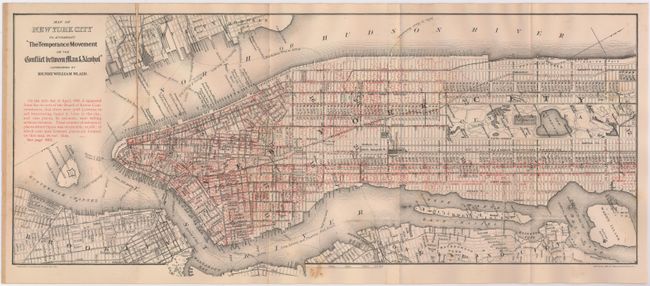
Auction 146, Lot 245
Subject: New York City, New York
[Lot of 2] Liquordom in New York City [and] Map of New York City to Accompany "the Temperance Movement or the Conflict Between Man & Alcohol", 1883-86
Size: See Description
Estimate: $150 - $200
Sold for: $75
Closed on 9/4/2013
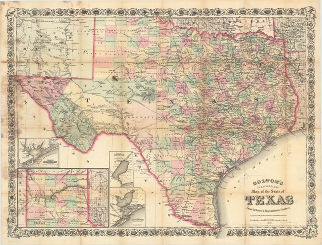
Auction 146, Lot 263
Subject: Texas
Colton, G.W. & C.B.
Colton's "New Medium" Map of the State of Texas from the Latest & Most Authentic Sources, 1879
Size: 25.5 x 19.3 inches (64.8 x 49 cm)
Estimate: $2,000 - $2,500
Rare Pocket Map of Texas
Unsold
Closed on 9/4/2013
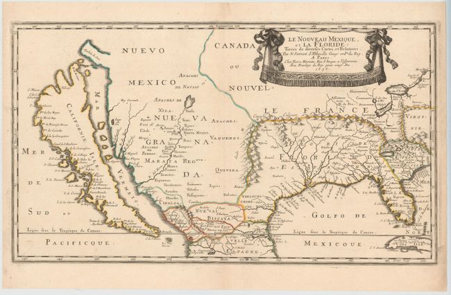
Auction 146, Lot 269
Subject: Colonial United States & Mexico
Sanson, Nicolas
Le Nouveau Mexique, et la Floride…, 1656
Size: 21.5 x 12.3 inches (54.6 x 31.2 cm)
Estimate: $5,500 - $7,000
First Edition of Sanson's Important Map of the American Southwest
Sold for: $4,000
Closed on 9/4/2013
87 lots
Page 1 of 2