Subject: Colonial New England & Mid-Atlantic
Period: 1775 (dated)
Publication:
Color: Hand Color
Size:
36.2 x 28.5 inches
91.9 x 72.4 cm
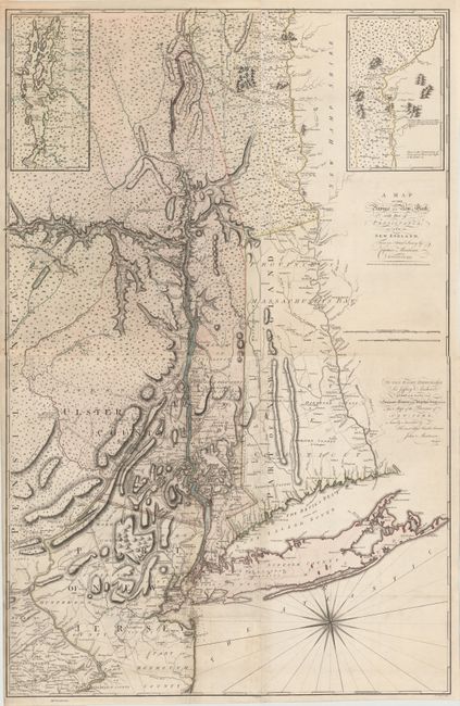
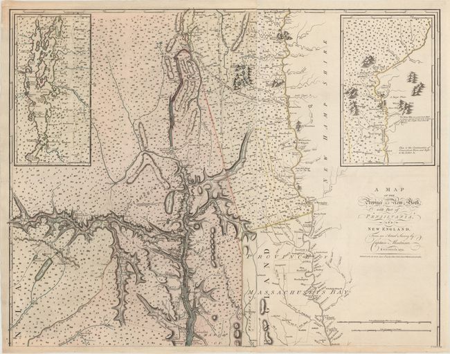
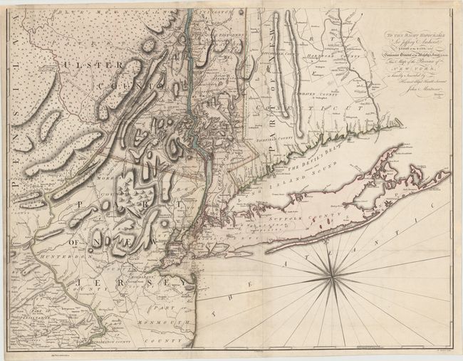
This map, issued during the Revolutionary War era, is one of the most detailed maps of the province of New York by a British military engineer. The map was created by actual surveys by John Montresor, who was trained by his father, an engineer in the British royal army. Montresor joined the 48th Regiment and served under General Braddock during the failed campaign against Fort Duquesne in 1756. In 1765 Montresor was commissioned by General Thomas Gage to compile a map of New York City in anticipation of unrest at the close of the French and Indian War. Shortly thereafter, Montresor returned to England with several draft maps of New York and the surrounding areas, and proceeded to work with the firm of John Rocque for engraving and printing. Although his map of New York City (A Plan of the City of New-York & its Environs) was published in 1767, Montresor's map of the province did not appear until 1775. His map of New York and the surrounding provinces was critical at the outbreak of the American Revolution for providing good information on the colonies for strategic and military planning.
The map covers the area from the Connecticut River west to the Hudson River and Mohawk Valley, and from Long Island north to Lake Champlain. The map shows counties, churches, forts, manors, roads and the names of some residents among its amazing details. The southwest sheet gives special attention to the boundary line between New York and New Jersey, which had been under contention since the Duke of York had granted New Jersey to Sir George Carteret and John, Lord Berkeley in 1664. Three different locations for the boundary line are indicated on Montresor's map, labeled as the "division line of 1719," the line "in favor of the Crown of the Province of New York," and the "more reputed jurisdiction line … for upwards of 50 years past." The boundary line was finally settled in 1764 and surveyed by Bernard Ratzer in 1769. Although Montresor was apparently aware of the official boundary line as evidenced by his own journals, he did not add the line to this map. The northwest sheet shows extensive detail of the river systems, lakes and topography in the region, with Lake Champlain depicted in a large inset. Both northern sheets are filled with miniature trees, symbolizing the vast forested areas. Montresor's map was also one of the first to show good detail of present-day Vermont, and included an inset on the northeast sheet showing the continuation of the Connecticut River into northern Vermont, noting the White Hills.
The map is dedicated to Sir Jeffrey Amherst, a general in the British Army and royal governor of Virginia from 1759 until 1768. Engraved by P. Andrews and published by Andrew Dury. This is the second state of four, with Tyionderogha or Tienderoga still located on the east bank and corrected to Ticonderoga. On four sheets, with the two northern sheets and the two southern sheets professionally joined. Size varies slightly. If fully joined, the map would measure 36.2 x 56.5".
References: Pritchard & Taliaferro #45; McCorkle #775.9, Sellers & van Ee #1066; Stevens & Tree #42(b).
Condition: A
A fine impression on watermarked paper. There is light soiling on bottom left sheet and a professionally repaired fold separation on Staten Island.