Subject: World
Period: 1700 (circa)
Publication: Le Neptune Francois
Color: Hand Color
Size:
35.6 x 23.1 inches
90.4 x 58.7 cm
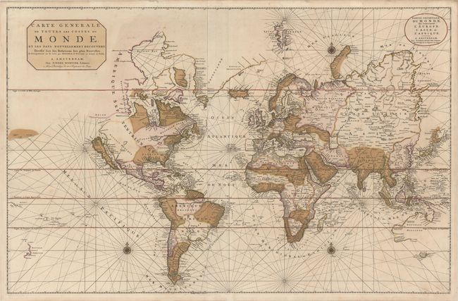
Fine example of this large world map on Mercator's projection, published in Mortier's counterfeit version of Le Neptune Francois in 1693. The original Neptune Francois was published in France by Hubert Jaillot in 1693, but Mortier re-engraved the maps the same year and published his version in Amsterdam with French, Dutch and English text. The known coastlines are accurate for the period but many interior details from recent discoveries have been omitted. The Great Lakes are depicted as a large Mer Douce with two smaller unnamed lakes. California is shown as an island on the Sanson model. This is the second state with Hudson Bay entirely re-engraved to now include three large islands and a distinctive Northwest Passage with Mer Glaciale extending through to the Detroit d' Anian, just to the north of California. The northeastern coast of Asia is truncated, but several promontories have been added. Australia is charted according to the discoveries of Tasman's voyages and many of the earlier Dutch discoveries. Two sheets joined, as issued.
References: Shirley #559.
Condition: B+
Original color with gilt highlights, minor soiling, and a few small cracks caused by the oxidation of the green pigment that have been archivally repaired.