Showing Featured Lots(remove filter)
Showing results for:Auction 141
Catalog Archive
89 lots
Page 1 of 2
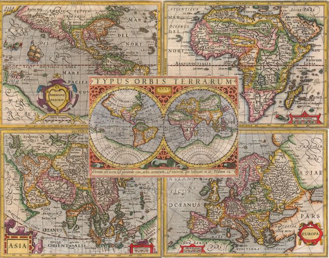
Auction 141, Lot 6
Subject: World & Continents
Mercator/Hondius
[Lot of 5] Typus Orbis Terrarum [and] Americae Descrip [and] Africae Descriptio [and] Asia [and] Europa, 1609
Size: 7.8 x 6 inches (19.8 x 15.2 cm)
Estimate: $2,400 - $3,000
Sold for: $3,250
Closed on 9/5/2012
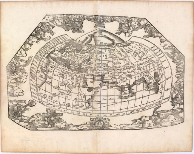
Auction 141, Lot 9
Subject: World
Waldseemuller/Fries
[Title on Verso] Tabula Moder. Gronlandiae et Russiae, 1525
Size: 18 x 11.1 inches (45.7 x 28.2 cm)
Estimate: $4,000 - $5,000
Very Rare Original Color
Sold for: $3,000
Closed on 9/5/2012
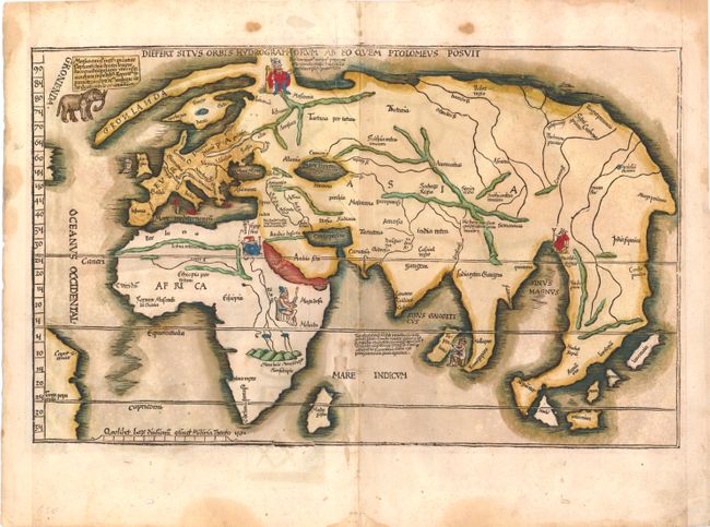
Auction 141, Lot 10
Subject: World
Ptolemy/Fries
[Untitled - World], 1535
Size: 18.2 x 11.7 inches (46.2 x 29.7 cm)
Estimate: $4,000 - $4,500
Unsold
Closed on 9/5/2012
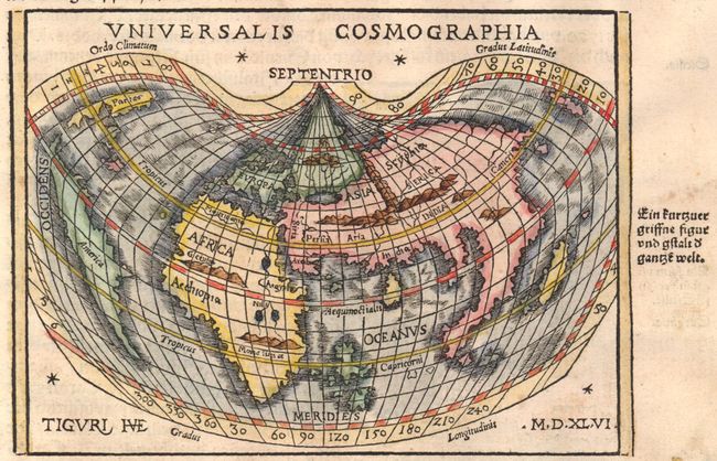
Auction 141, Lot 11
Subject: World
Honter, Jon Coronensis
Universalis Cosmographia, 1548
Size: 6.5 x 4.8 inches (16.5 x 12.2 cm)
Estimate: $1,400 - $1,700
Honter's Heart-Shaped Map of the World
Sold for: $1,000
Closed on 9/5/2012
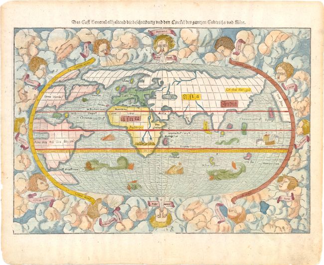
Auction 141, Lot 12
Subject: World
Munster, Sebastian
Das Erst General Inhaltend die Beschreibung und den Circkel des Gantzen Erdtrichs und More, 1550-78
Size: 15.1 x 10.5 inches (38.4 x 26.7 cm)
Estimate: $2,000 - $2,300
Sold for: $1,600
Closed on 9/5/2012
Auction 141, Lot 16
Subject: World
Ritter, Franz
[Untitled - World], 1613
Size: 9 x 9 inches (22.9 x 22.9 cm)
Estimate: $3,750 - $4,500
Ritter's Circular Sundial World Map
Unsold
Closed on 9/5/2012
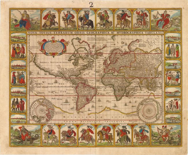
Auction 141, Lot 17
Subject: World
Visscher, Claes Janszoon
Nova Totius Terrarum Orbis Geographica ac Hydrographica Tabula Auctore N. I. Piscator, 1652
Size: 22.3 x 17.9 inches (56.6 x 45.5 cm)
Estimate: $15,000 - $18,000
Visscher's Rare Carte-a-Figures World Map
Sold for: $10,500
Closed on 9/5/2012
Auction 141, Lot 18
Subject: World
Arias Montanus, Benito
Benedict Arias Montanus Sacrae Geographiae Tabulam ex Antiquissimorum Cultor. Familiis a Mose Recensitis…, 1660
Size: 20.5 x 12.3 inches (52.1 x 31.2 cm)
Estimate: $6,500 - $7,000
Unsold
Closed on 9/5/2012

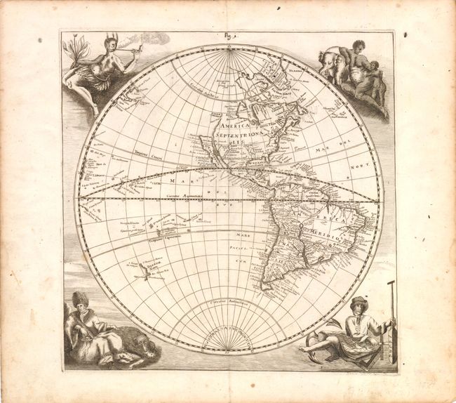
Auction 141, Lot 20
Subject: World
Wit, Frederick de
Nova Orbis Tabula, in Lucem Edita, 1688
Size: 22.3 x 18.8 inches (56.6 x 47.8 cm)
Estimate: $4,500 - $5,500
De Wit's Stunning Double-Hemisphere Map
Unsold
Closed on 9/5/2012
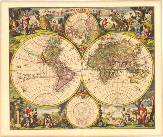
Auction 141, Lot 25
Subject: World
Valck, Gerard and Leonard
Orbis Terrarum Nova et Accurata Tabula, 1700
Size: 22.5 x 19 inches (57.2 x 48.3 cm)
Estimate: $6,500 - $7,500
Sold for: $3,900
Closed on 9/5/2012
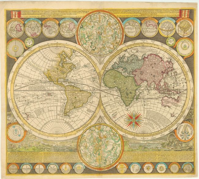
Auction 141, Lot 26
Subject: World
Zurner, Adam Friedrich
Planisphaerium Terrestre cum Utroque Coelesti Hemisphaerio, sive Diversa Orbis Terraquei..., 1700
Size: 23 x 20 inches (58.4 x 50.8 cm)
Estimate: $4,750 - $5,500
Unsold
Closed on 9/5/2012
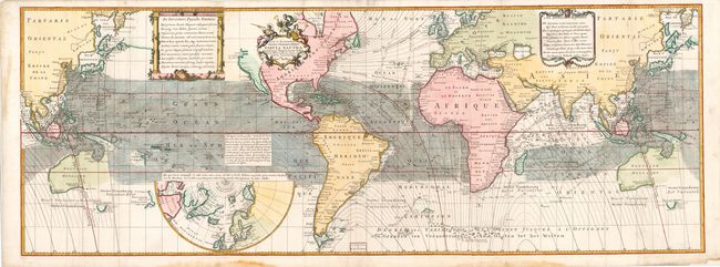
Auction 141, Lot 31
Subject: World
Halley, Edmund
Nova & Accuratissima Totius Terrarum Orbis Tabula Nautica Variatum Magneticarum Index Juxta Observationes Anno 1700 Habitas Constructa per Edm: Halley, 1740
Size: 56.5 x 20.5 inches (143.5 x 52.1 cm)
Estimate: $11,000 - $14,000
Halley's Rare World Map Depicting Trade Winds and Isogonic Lines
Sold for: $8,000
Closed on 9/5/2012
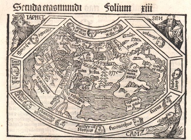
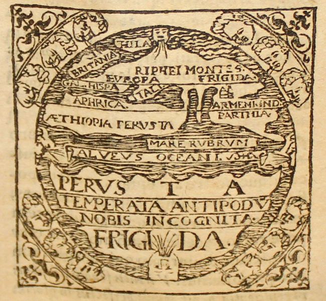
Auction 141, Lot 46
Subject: Ancient World
Schonsperger, Johann
Secunda Etas Mundi, 1496
Size: 5.8 x 4 inches (14.7 x 10.2 cm)
Estimate: $5,500 - $6,500
A Miniature Version of Schedel's Ancient World Map
Sold for: $3,000
Closed on 9/5/2012
Auction 141, Lot 48
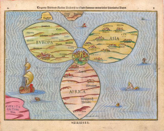
Subject: Ancient World
Bunting, Heinrich
Die Ganze Welt in ein Kleeblat / Welches ist der Stadt Hannover Meines Lieben Vaterlandes Wapen, 1581
Size: 14.3 x 10.5 inches (36.3 x 26.7 cm)
Estimate: $7,000 - $8,000
Bunting's Clover Leaf Map of the Old World
Sold for: $5,000
Closed on 9/5/2012
Auction 141, Lot 50
Subject: Ancient World
Macrobius, Ambrosius Aurelius Theodo
Macrobii Ambrosii Aurelii Theodosii, uiri Consularis, et Illustris, In Somnium Scipionis, Lib. II. Saturnaliorum. Lib. VII…, 1597
Size: 3.5 x 5 inches (8.9 x 12.7 cm)
Estimate: $1,600 - $1,800
Macrobius' Miniature Ancient World Map
Unsold
Closed on 9/5/2012
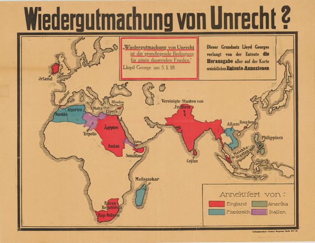
Auction 141, Lot 54
Subject: Eastern Hemisphere
Wiedergutmachung von Unrecht?, 1919
Size: 22.1 x 17.7 inches (56.1 x 45 cm)
Estimate: $1,000 - $1,500
Fascinating World War I Propaganda Map
Sold for: $750
Closed on 9/5/2012
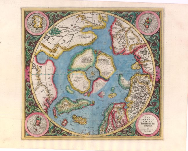
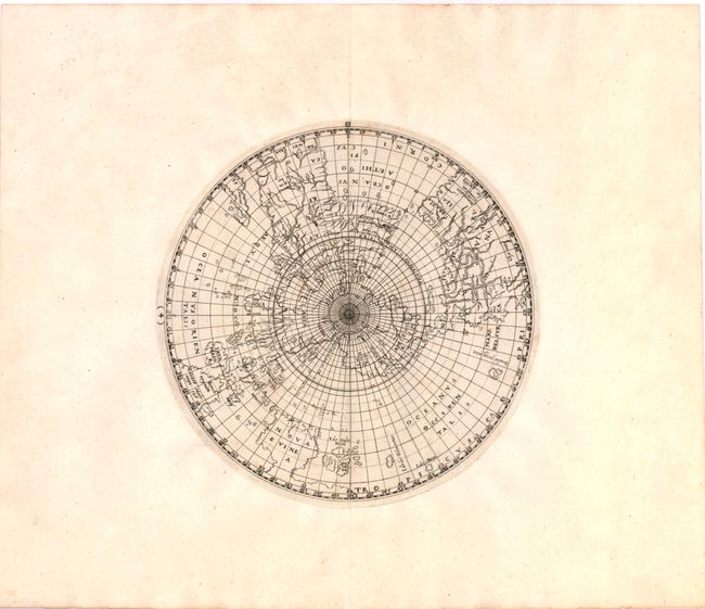
Auction 141, Lot 55
Subject: North Pole
Mercator, Gerard
Septentrionalium Terrarum Descriptio, 1606
Size: 15.5 x 14.8 inches (39.4 x 37.6 cm)
Estimate: $2,200 - $3,000
The First Printed Map Devoted to the Arctic
Sold for: $1,800
Closed on 9/5/2012
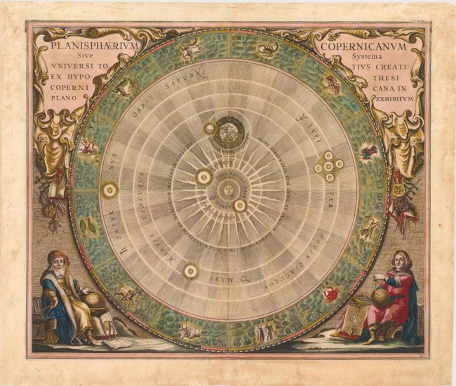
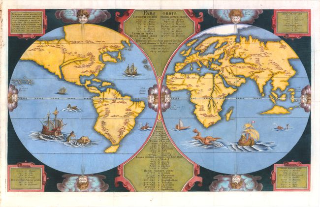
Auction 141, Lot 62
Subject: Solar System
Cellarius, Andreas
Planisphaerium Copernicanum sive Systema Universi Totius Creati ex Hypothesi Copernicana in Plano Exhibitum, 1661
Size: 20.8 x 17.5 inches (52.8 x 44.5 cm)
Estimate: $2,400 - $3,000
One of the Most Sought after Charts from this Famous Work
Sold for: $2,750
Closed on 9/5/2012
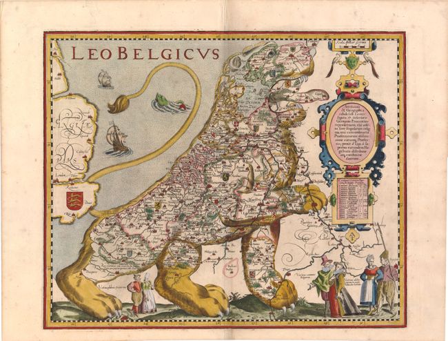
Auction 141, Lot 67
Subject: Cartographic Miscellany, Belgium and Netherlands
Keere, Pieter Van Den
Leo Belgicus, 1617
Size: 17.8 x 14.5 inches (45.2 x 36.8 cm)
Estimate: $19,000 - $24,000
The Most Popular of the "Lions of Belgium"
Sold for: $13,000
Closed on 9/5/2012
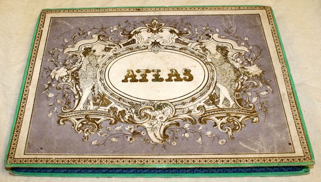
Auction 141, Lot 69
Subject: Puzzle Maps - World, Europe & France
Logerot, Auguste
[Puzzle] Atlas, 1850
Size: 12 x 9.3 inches (30.5 x 23.6 cm)
Estimate: $240 - $300
Complete 19th Century Puzzle Map Set in Original Box
Sold for: $150
Closed on 9/5/2012
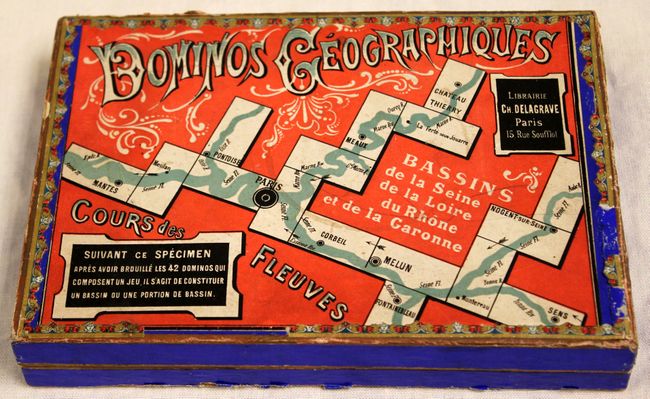
Auction 141, Lot 71
Subject: Game - Rivers in France
[Game] Dominos Geographiques, 1890
Size: 9 x 6.3 inches (22.9 x 16 cm)
Estimate: $275 - $350
Complete Domino Game in Original Box
Sold for: $170
Closed on 9/5/2012
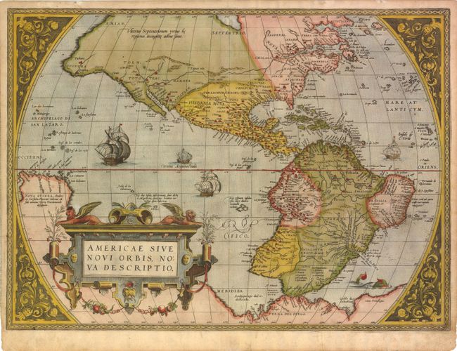
Auction 141, Lot 72
Subject: Western Hemisphere
Ortelius, Abraham
Americae sive Novi Orbis, Nova Descriptio, 1574
Size: 20 x 14.5 inches (50.8 x 36.8 cm)
Estimate: $6,000 - $7,000
First Plate of Ortelius' Influential Map of the New World
Sold for: $4,500
Closed on 9/5/2012
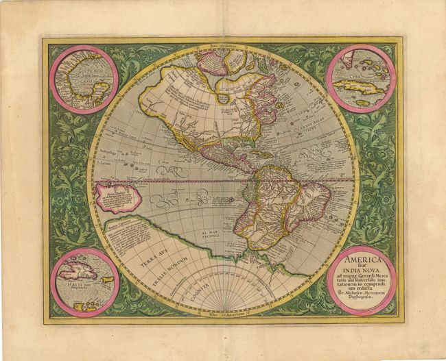
Auction 141, Lot 73
Subject: Western Hemisphere
Mercator, Michael
America sive India Nova ad Magnae Gerardi Mercatoris aui Universalis Imitationem in Compendium Redacta, 1613
Size: 18 x 14.5 inches (45.7 x 36.8 cm)
Estimate: $4,750 - $6,000
Sold for: $3,500
Closed on 9/5/2012
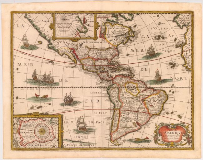
Auction 141, Lot 74
Subject: Western Hemisphere
Bertius/Tavernier
Carte de l'Amerique Corrigee, et Augmentee, dessus Toutes les Aultres cy devant Faictes par P. Bertius, 1627
Size: 20 x 15.2 inches (50.8 x 38.6 cm)
Estimate: $1,800 - $2,000
Sold for: $1,800
Closed on 9/5/2012
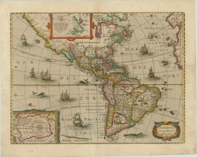
Auction 141, Lot 75
Subject: Western Hemisphere
Hondius, Henricus
America Noviter Delineata, 1631
Size: 19.9 x 15 inches (50.5 x 38.1 cm)
Estimate: $2,400 - $3,000
Sold for: $1,800
Closed on 9/5/2012
Auction 141, Lot 77
Subject: Western Hemisphere
Happel, Everard Werner
[Untitled - Western Hemisphere], 1687
Size: 11.3 x 11.5 inches (28.7 x 29.2 cm)
Estimate: $1,400 - $1,800
Unsold
Closed on 9/5/2012
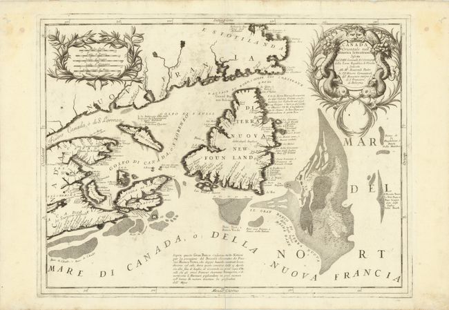
Auction 141, Lot 115
Subject: Eastern Canada
Coronelli, Vincenzo Maria
Canada Orientale nell'America Settentrionale…, 1695
Size: 24 x 18 inches (61 x 45.7 cm)
Estimate: $1,100 - $1,400
Sold for: $800
Closed on 9/5/2012
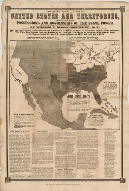
Auction 141, Lot 146
Subject: United States, Civil War
Map of the United States and Territories, Showing the Possessions and Aggressions of the Slave Power, 1856
Size: 26 x 42 inches (66 x 106.7 cm)
Estimate: $2,000 - $4,000
Fascinating and Rare Example of Political Propaganda and Thematic Mapping
Sold for: $4,750
Closed on 9/5/2012
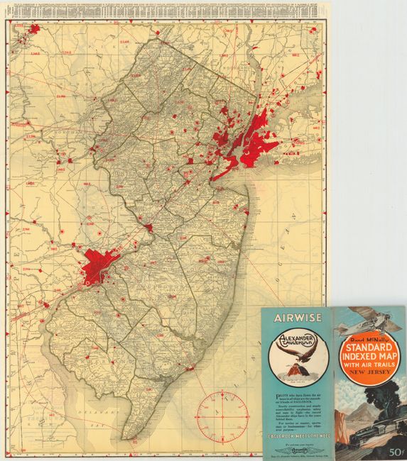
Auction 141, Lot 152
Subject: United States
Rand McNally & Co.
[Lot of 46] Rand McNally Standard Indexed Map with Air Trails, 1929-30
Size: 18.5 x 26 inches (47 x 66 cm)
Estimate: $1,200 - $1,500
Rare Rand McNally "Air Trails" Pocket Maps
Unsold
Closed on 9/5/2012
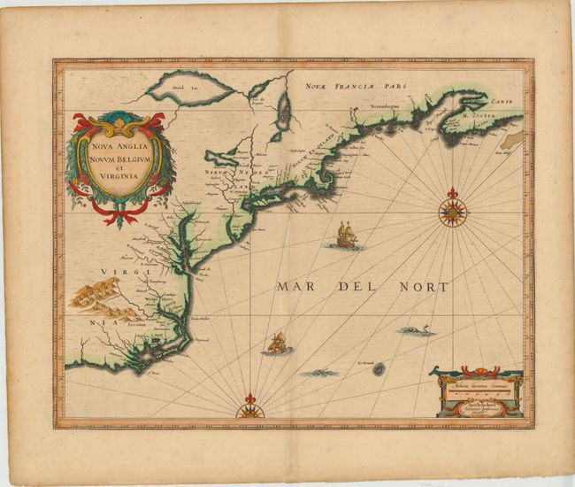
Auction 141, Lot 160
Subject: Colonial New England and Mid-Atlantic
Jansson, Jan
Nova Anglia Novum Belgium et Virginia, 1639-42
Size: 20 x 15.3 inches (50.8 x 38.9 cm)
Estimate: $2,000 - $2,300
Jansson's Influential Map of the East Coast
Unsold
Closed on 9/5/2012
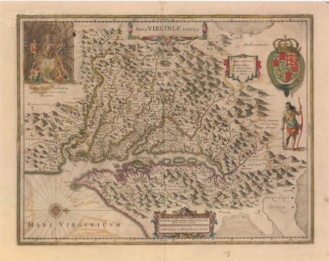
Auction 141, Lot 165
Subject: Colonial Mid-Atlantic
Hondius, Henricus
Nova Virginiae Tabula, 1647
Size: 19.5 x 15 inches (49.5 x 38.1 cm)
Estimate: $2,000 - $2,400
One of the Most Important 17th Century Maps of the Chesapeake Bay
Sold for: $1,500
Closed on 9/5/2012
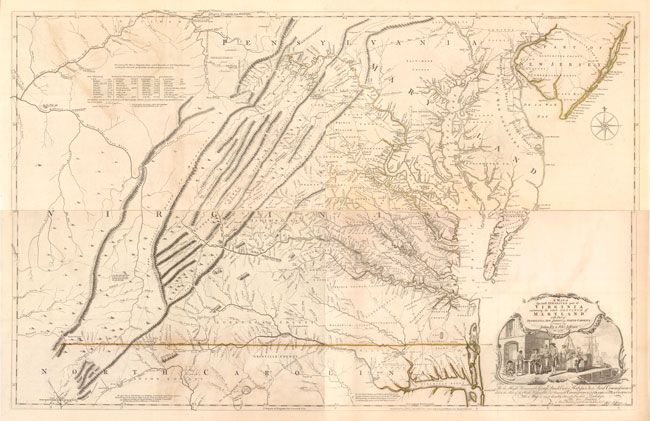
Auction 141, Lot 167
Subject: Colonial Virginia, Maryland
Fry, Joshua & Jefferson, Peter
A Map of the Most Inhabited Part of Virginia Containing the Whole Province of Maryland with Part of Pensilvania, New Jersey and North Carolina, 1775
Size: 48.5 x 31 inches (123.2 x 78.7 cm)
Estimate: $32,000 - $40,000
1775 Edition of the Landmark Fry-Jefferson Map of Virginia and Maryland
Sold for: $24,000
Closed on 9/5/2012
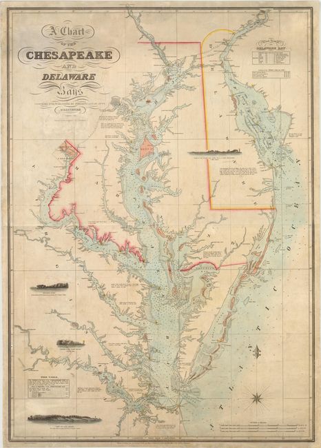
Auction 141, Lot 169
Subject: Mid-Atlantic United States, Chesapeake and Delaware Bays
Lucas, Fielding
A Chart of the Chesapeake and Delaware Bays, 1852
Size: 28.3 x 40 inches (71.9 x 101.6 cm)
Estimate: $8,000 - $10,000
Scarce Sea Chart of the Chesapeake and Delaware Bays
Unsold
Closed on 9/5/2012
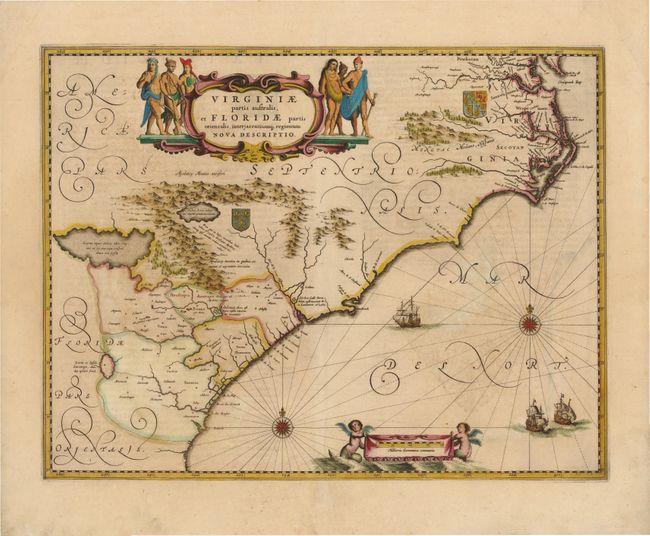
Auction 141, Lot 171
Subject: Colonial Southeast
Jansson, Jan
Virginiae Partis Australis, et Floridae Partis Orientalis, interjacentiumq Regionum Nova Descriptio, 1639
Size: 19.8 x 15.3 inches (50.3 x 38.9 cm)
Estimate: $1,600 - $1,800
Unsold
Closed on 9/5/2012
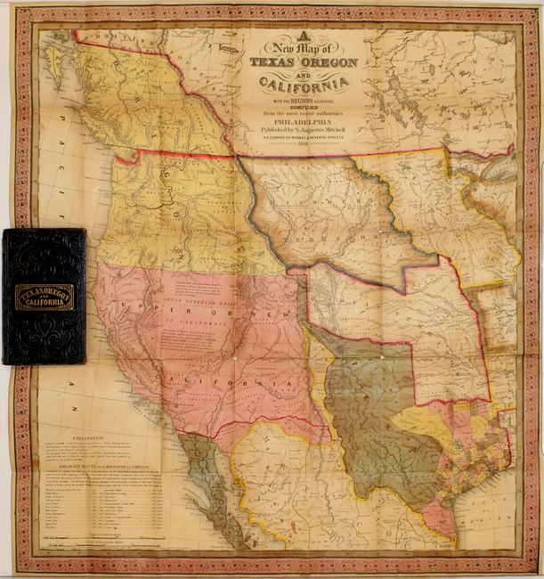
Auction 141, Lot 184
Subject: Western United States
Mitchell, Samuel Augustus
A New Map of Texas Oregon and California, 1846
Size: 19 x 21 inches (48.3 x 53.3 cm)
Estimate: $9,000 - $11,000
Mitchell's Famous Map Showing the New State of Texas
Unsold
Closed on 9/5/2012
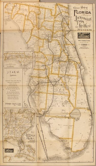
Auction 141, Lot 213
Subject: Florida
Matthews-Northrup Co
Correct Map of Florida Showing the Jacksonville Tampa and Key West System and Connections [with book] The Tarpon or "Silver King", 1889
Size: 15.5 x 27.5 inches (39.4 x 69.9 cm)
Estimate: $1,400 - $1,700
Sold for: $1,000
Closed on 9/5/2012
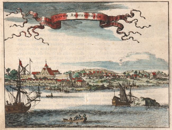
Auction 141, Lot 251
Subject: New York City, New York
Montanus, Arnoldus
Novum Amsterodamum, 1671
Size: 6.5 x 5 inches (16.5 x 12.7 cm)
Estimate: $550 - $650
One of the Earliest Views of New York City
Sold for: $600
Closed on 9/5/2012
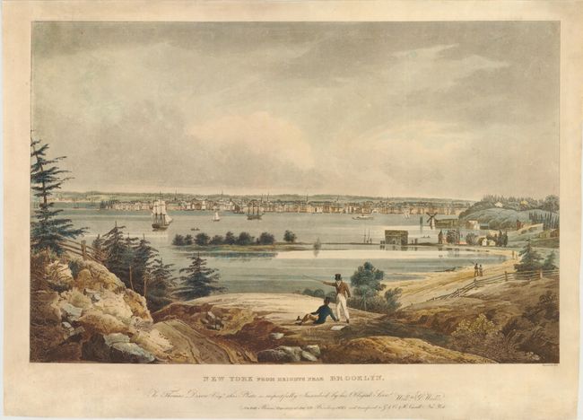
Auction 141, Lot 252
Subject: New York City, New York
New York from Heights Near Brooklyn, 1828
Size: 24.5 x 15.7 inches (62.2 x 39.9 cm)
Estimate: $2,000 - $2,500
One of the Most Beautiful Early 19th Century Views of NYC
Sold for: $1,600
Closed on 9/5/2012
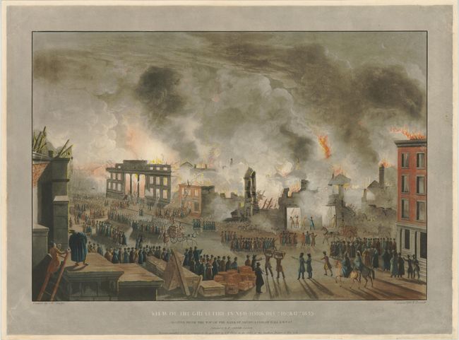
Auction 141, Lot 253
Subject: New York City, New York
[Lot of 2] View of the Great Fire in New-York, Decr. 16th. & 17th. 1835 [and] View of the Ruins After the Great Fire in New-York, Decr. 16th. & 17th. 1835, 1836
Size: 23.8 x 16.2 inches (60.5 x 41.1 cm)
Estimate: $2,750 - $3,500
Dramatic Views of the Great Fire of New York in 1835
Sold for: $1,400
Closed on 9/5/2012
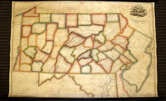
Auction 141, Lot 267
Subject: Pennsylvania
Melish, John
Map of Pennsylvania, Constructed from the County Surveys Authorized by the State; and other Original Documents...Corrected & Improved to 1826, 1826
Size: 73.5 x 42.5 inches (186.7 x 108 cm)
Estimate: $16,000 - $20,000
Melish's Greatest Published Work
Unsold
Closed on 9/5/2012
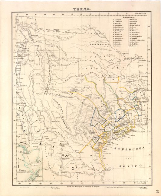
Auction 141, Lot 270
Subject: Texas
Flemming, Carl
Texas, 1845
Size: 12.6 x 15.8 inches (32 x 40.1 cm)
Estimate: $1,000 - $1,400
Scarce German Map Showing the Republic of Texas
Sold for: $700
Closed on 9/5/2012
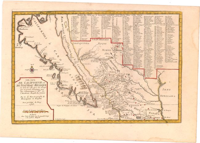
Auction 141, Lot 288
Subject: California, Southwest and Mexico
Fer, Nicolas de
Cette Carte de Californie et du Nouveau Mexique est Tiree de celle qui a ete Envoyee par un Grand d'Espagne pour etre Communiquee a Mrs. de l'Academie Royale des Sciences, 1705
Size: 13.5 x 9 inches (34.3 x 22.9 cm)
Estimate: $1,500 - $1,900
Sold for: $1,100
Closed on 9/5/2012
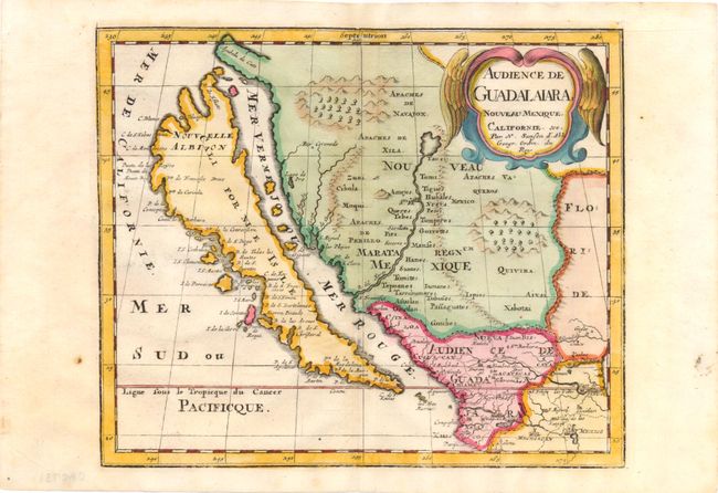
Auction 141, Lot 289
Subject: United States & Mexico, California
Sanson, Nicolas
Audience de Guadalaiara, Nouveau Mexique, Californie, &c., 1715
Size: 9.3 x 7.8 inches (23.6 x 19.8 cm)
Estimate: $950 - $1,100
Sold for: $650
Closed on 9/5/2012
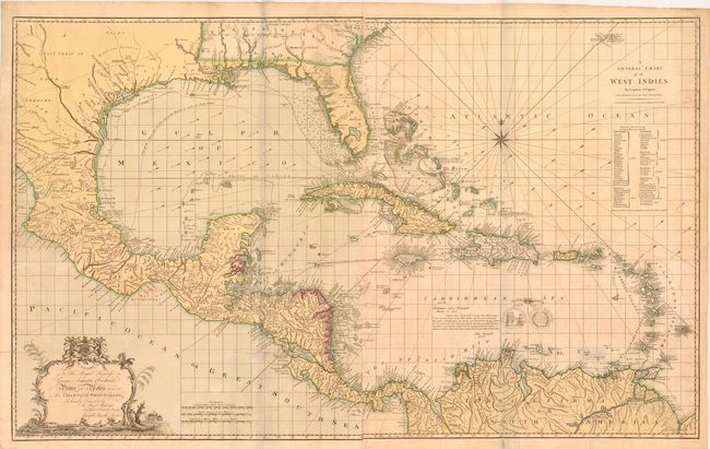
Auction 141, Lot 304
Subject: Gulf of Mexico and Caribbean
Speer, Joseph Smith (Capt)
A General Chart of the West Indies / To His Royal Highness George Augustus Frederick Prince of Wales &c. &c. &c. this Chart of the West Indies, is Humbly Inscribed…, 1796
Size: 45.5 x 28.3 inches (115.6 x 71.9 cm)
Estimate: $3,750 - $5,000
Sold for: $3,000
Closed on 9/5/2012
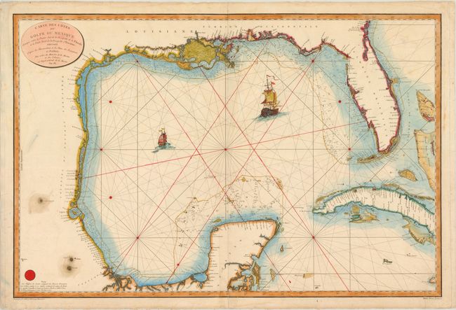
Auction 141, Lot 305
Subject: Gulf of Mexico and Caribbean
Depot de la Marine
Carte des Cotes du Golfe du Mexique Compris entre la Pointe Sud de la Presqu'Ile de la Floride et la Pointe Nord de la Presqu'Ile d'Yucatan…, 1800
Size: 35.8 x 23.8 inches (90.9 x 60.5 cm)
Estimate: $1,100 - $1,500
Important Map for the Texas Collector
Sold for: $800
Closed on 9/5/2012
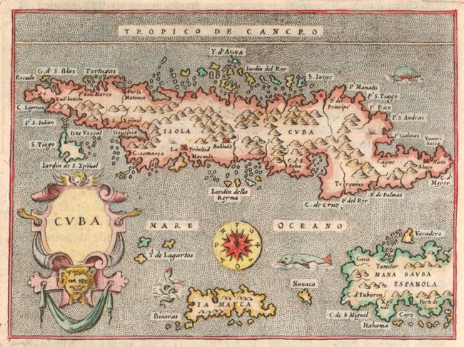
Auction 141, Lot 313
Subject: Cuba
Porcacchi, Tomaso
Cuba, 1590
Size: 5.5 x 4 inches (14 x 10.2 cm)
Estimate: $350 - $400
Sold for: $250
Closed on 9/5/2012
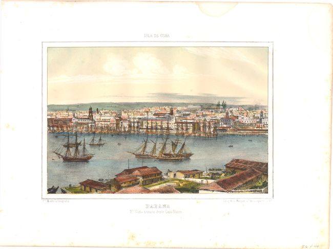
Auction 141, Lot 315
Subject: Havana, Cuba
Habana, 1848
Size: 10.8 x 7.3 inches (27.4 x 18.5 cm)
Estimate: $550 - $700
Sold for: $300
Closed on 9/5/2012
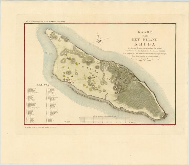
Auction 141, Lot 328
Subject: Aruba
Kaart van Het Eiland Aruba Gevolgd Naar de Opmeting in den Jare 1820 Gedaan, Onder Directie van den Kapitein ter Zee W.A. van Spengler en in den Jare 1825 met Verscheidene Nieuwe Bepalingen Verrijkt, 1827
Size: 17.4 x 11.7 inches (44.2 x 29.7 cm)
Estimate: $1,000 - $1,400
Sold for: $900
Closed on 9/5/2012
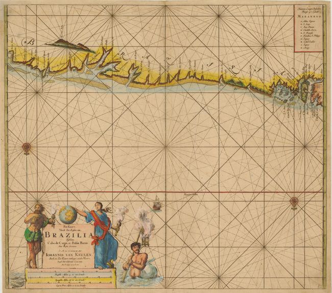
Auction 141, Lot 351
Subject: Brazil
Keulen, Johannes van
Pas-Kaart, van de Zee-Kusten van, Brazilia tusschen, Cabo de Cuma, en Bahia Baxa…, 1695
Size: 22.5 x 19.8 inches (57.2 x 50.3 cm)
Estimate: $900 - $1,100
Sold for: $650
Closed on 9/5/2012
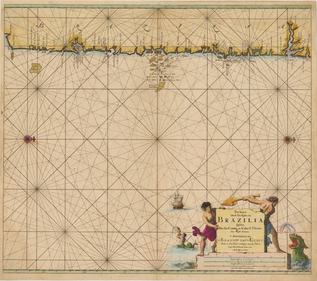
Auction 141, Lot 352
Subject: Brazil
Keulen, Johannes van
Pas-Kaart van de Zee-Kusten van Brazilia, tusschen Rio das Contas en Cabo S. Thome…, 1695
Size: 23 x 20.3 inches (58.4 x 51.6 cm)
Estimate: $1,000 - $1,300
Sold for: $750
Closed on 9/5/2012
89 lots
Page 1 of 2