Subject: Gulf of Mexico and Caribbean
Period: 1796 (dated)
Publication:
Color: Hand Color
Size:
45.5 x 28.3 inches
115.6 x 71.9 cm
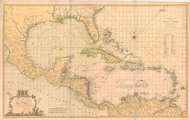
This impressive large-scale chart of the Gulf of Mexico includes the southern United States, Central America, the West Indies, and northern South America. A table at far right lists the colonial possessions of the English, French, Spanish, Dutch and Danish, and gives direction as to how they should be colored on the chart. The United States boundaries reflect the 1796 Pinckney's Treaty, extending to the Mississippi River in the west and south to northern Florida. Pinckney's Treaty, also known as the Treaty of San Lorenzo or the Treaty of Madrid, defined the boundaries of the United States, gave the U.S. navigation rights on the Mississippi River, and established intentions of friendship between the United States and Spain. The Spanish possessions west of the Mississippi are left largely blank, with Ticas (Texas), Wandering Indians, and A Vast Tract of Unknown Land noted. Political boundaries, cities, forts, Indian tribal territories, and topographical details are well depicted. The waters are filled with soundings, navigational hazards, arrows identifying the direction of trade winds, and the routes of the Spanish gold fleet. The Pacific Ocean is filled with a large rococo-style cartouche dedicating the map to George Augustus Frederick, Prince of Wales, who became the King of the United Kingdom of Great Britain and Ireland in 1820. There is an engraved endorsement by John Pownall, Secretary to the Plantation Office, certifying that the chart incorporates the "latest and most accurate surveys." The map was first published in 1774; this is the second state republished by Robert Wilkinson, with an "Honorary Gold Medal" seal given to Speer and engraved just above South America. Engraved by Thomas Bowen. On two sheets, joined.
Captain Joseph Smith Speer was an officer in the Royal Navy who spent many years in the West Indies. His most famous work, the West-India Pilot, contained 13 maps of the region, published in 1766, followed by an extended 26-map edition in 1771.
References: Sellers & Van Ee #1699.
Condition: B
Old color with light offsetting and a few faint damp stains. There are a few fold separations between the 11th and 12th parallels and in South America that were previously closed with cello tape, causing some discoloration. The cello tape has been removed and the separations have all been closed with archival materials. A 1" tear just below Honduras, a small hole near New Leon, and a small hole east of the Bahamas have also all been archivally repaired. There is a tiny pinhole in the Gulf of Mexico. Despite these imperfections, this is a good example of such a large and rare map.


