Subject: World
Period: 1740 (circa)
Publication:
Color: Hand Color
Size:
56.5 x 20.5 inches
143.5 x 52.1 cm
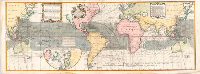
Edmund Halley (1656-1742) was an English astronomer, meteorologist, and physicist best known for calculating the orbit of the eponymous Halley's Comet. In 1686 Halley became the first to depict trade winds and monsoons on a map, which appeared on his untitled diagrammatic world map. Halley was granted temporary Captainship in the Royal Navy for his scientific voyage through the Atlantic on the ship Paramore, during which he investigated the laws governing the variation of the compass. He published his findings in General Chart of the Variation of the Compass (1701), a chart of the Atlantic ocean which was the first to use isogonic, or Halleyan, lines to show the pattern of magnetic variation. The following year Halley extended his chart to the western Pacific, using data from journals of voyages in the Indian Seas.
Published by Reinier and Joshua Ottens, this world map on Mercator's projection records both trade winds and magnetic variation, being the first map to represent both aspects of Halley's ground-breaking work. Numerous explorers' discoveries are noted throughout, and the route of Halley's voyage is also shown. The interiors of the continents are left largely blank, with place names focused on the coasts. Eastern Asia and the south Pacific are repeated on both sides of the map, and Australia (Nouvelle Hollande), Tasmania (Pays de Diemen), New Guinea (Nouv' Guine), and New Zealand (Nouvelle Zeelande) are only partially delineated. A large semi-circular inset of the North polar region is depicted in the south Pacific. There are two explanatory blocks of text in Latin and French at left, and a decorative cartouche at right dedicated to Queen Anne, who ascended the thrones of England, Scotland and Ireland in 1702. The decorative title cartouche is surmounted by female figures representing astronomy, navigation, and exploration. Printed on three sheets, joined.
References: Suarez (Pacific) p.111, fig.104; Wagner (NW) #540; Shirley, p.xiv.
Condition: A
An excellent example with two printer's creases at bottom near polar inset and very minor soiling. There are a few minor fold separations confined to the blank margins repaired with tissue on verso as well as several damp stains in blank margins, not affecting map.


