Catalog Archive
Auction 171, Lot 729

"Chart of Part of the South Sea, Shewing the Tracts & Discoveries Made by His Majesty's Ships Dolphin, Commodore Byron, & Tamer, Capn Mouat, 1765 ... and Endeavour, Lieutenant Cooke, 1769", Cook, James (Capt.)

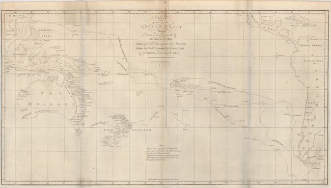
Subject: South Pacific Ocean

Period: 1773 (published)

Publication: Account of the Voyages Undertaken...in the Southern Hemisphere

Color: Black & White

Size:
26.3 x 14 inches
66.8 x 35.6 cm
Download High Resolution Image
(or just click on image to launch the Zoom viewer)

This chart of the South Pacific covers the region from Australia and Southeastern Asia to the western coast of South America, and is filled with the tracks of the explorers Cook, Byron, Wallis, and Cateret. Lands that are shaded indicate new discoveries by these parties and include eastern Australia, most of New Zealand, portions of New Guinea, and the Society Islands. Cook's new place names appear along the eastern coast of Australia including Botany Bay, C. Banks, and Pt. Solander. Engraved by W. Whitchurch and published by John Hawkesworth in his Account of the Voyages Undertaken...in the Southern Hemisphere.

References: Tooley (Australia) #321; Shirley (BL Atlases) G.HAWK-1a #1.

Condition: B+

Issued folding with faint offsetting, a bit of staining along the middle fold at top, and minor soiling. Narrow side margins. (The bluish hue along the fold lines in the image is caused by our scanner and is not on the physical map.)

Estimate: $1,000 - $1,300

Sold for: $550

Closed on 2/6/2019

Archived