Filtered by Category:Canada(Show All Categories)
Showing results for:Auction 163
Catalog Archive
26 lots
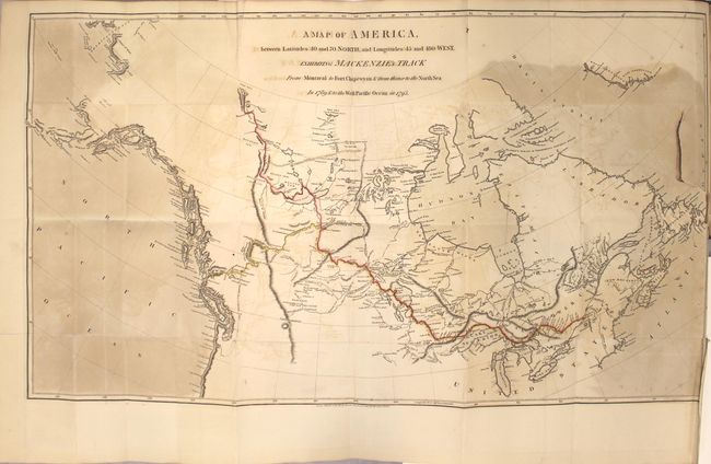
Auction 163, Lot 46
Subject: Canada
Mackenzie, Alexander
Voyages from Montreal, on the River St. Laurence, Through the Continent of North America, to the Frozen and Pacific Oceans; in the Years 1789 and 1793..., 1801
Size: 8.6 x 10.9 inches (21.8 x 27.7 cm)
Estimate: $5,500 - $6,500
First Edition of Mackenzie's Famous Account
Sold for: $4,000
Closed on 6/14/2017
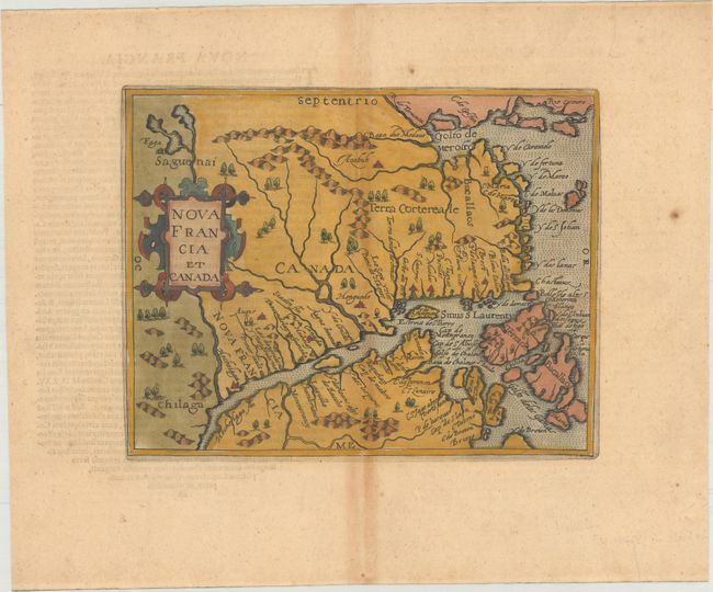
Auction 163, Lot 47
Subject: Eastern Canada
Metellus, Natalius Sequanus
Nova Francia et Canada, 1598
Size: 9.3 x 7.4 inches (23.6 x 18.8 cm)
Estimate: $1,300 - $1,600
Metellus's Rare Reduced Version of Wytfliet's Map of Eastern Canada
Sold for: $700
Closed on 6/14/2017
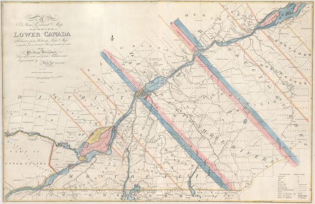
Auction 163, Lot 48
Subject: Eastern Canada, Quebec
Lay, Amos
A New Correct Map of the Seat of War in Lower Canada Protracted from Hollands Large Map Compiled from Actual Survey Made by Order of the Provincial Government..., 1814
Size: 33.1 x 21.6 inches (84.1 x 54.9 cm)
Estimate: $1,600 - $2,000
Lay's Update to Samuel Holland's Map
Unsold
Closed on 6/14/2017
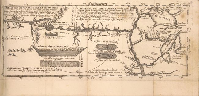
Auction 163, Lot 49
Subject: Colonial United States & Canada, Exploration, River Longue
Lahontan, Louis Armand, Baron de
[2 Volumes] Nouveaux Voyages de Mr Le Baron de Lahontan, dans l'Amerique Septentrionale... [and] Memoires de l'Amerique Septentrionale, ou la Suite des Voyages..., 1704-09
Size: 4 x 6.9 inches (10.2 x 17.5 cm)
Estimate: $1,400 - $1,700
Includes the Reduced, First State of Lahontan's Influential Map Depicting "Riviere Longue"
Sold for: $1,600
Closed on 6/14/2017
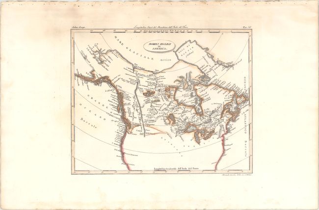
Auction 163, Lot 50
Subject: United States & Canada
Rossi, Luigi
Dominj Inglesi in America, 1820
Size: 9.8 x 7.8 inches (24.9 x 19.8 cm)
Estimate: $150 - $180
Unsold
Closed on 6/14/2017
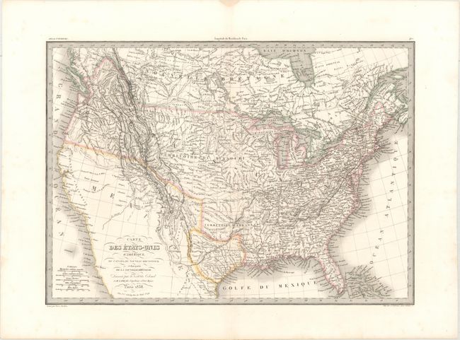
Auction 163, Lot 51
Subject: United States & Canada, Texas
Lapie/Tardieu
Carte des Etats-Unis d'Amerique, du Canada, du Nouveau Brunswick et d'Une Partie de la Nouvelle Bretagne, 1838
Size: 21.6 x 15.5 inches (54.9 x 39.4 cm)
Estimate: $350 - $425
Sold for: $250
Closed on 6/14/2017
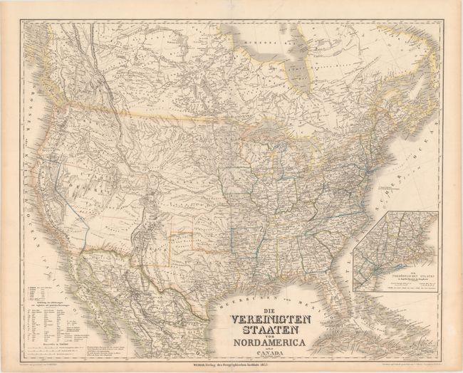
Auction 163, Lot 52
Subject: United States & Canada
Weimar Geographisches Institut
Die Vereinigten Staaten von Nord America nebst Canada, 1852
Size: 25.1 x 20.5 inches (63.8 x 52.1 cm)
Estimate: $475 - $600
Rare Map Showing the Territory of Deseret
Sold for: $350
Closed on 6/14/2017
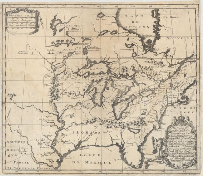
Auction 163, Lot 53
Subject: Colonial Eastern United States & Canada
Hennepin, Louis de (Fr.)
Charte eines sehr Grossen Landes nur Gantz Neulich in dem Mitternachtigen America..., 1698
Size: 16.9 x 14.5 inches (42.9 x 36.8 cm)
Estimate: $2,200 - $2,500
German Edition of Hennepin's Map of Eastern North America
Sold for: $1,500
Closed on 6/14/2017
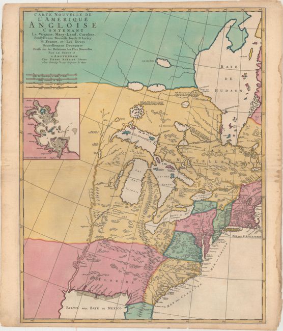
Auction 163, Lot 54
Subject: Colonial Eastern United States & Canada
Mortier, Pierre
Carte Nouvelle de l'Amerique Angloise Contenant la Virginie, Mary-Land, Caroline, Pensylvania Nouvelle Iorck. N: Iarsey N: France, et les Terres Nouvellement Decouerte..., 1700
Size: 18.3 x 23.3 inches (46.5 x 59.2 cm)
Estimate: $1,600 - $2,000
A Map Showing Fascinating Geographic Misconceptions
Sold for: $1,600
Closed on 6/14/2017
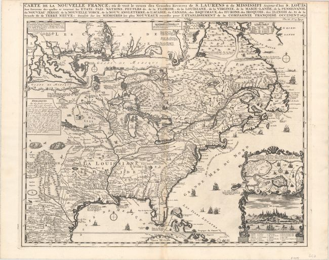
Auction 163, Lot 55
Subject: Colonial Eastern United States & Canada
Chatelain, Henry Abraham
Carte de la Nouvelle France, ou se voit le Cours des Grandes Rivieres de S. Laurens & de Mississipi Aujour d'hui S. Louis, aux Environs des-quelles se Trouvent les Etats, Pais, Nations, Peuples &c..., 1719
Size: 19.3 x 16.6 inches (49 x 42.2 cm)
Estimate: $2,500 - $3,250
One of the Most Informative 18th Century Maps of the French Possessions in North America
Sold for: $1,400
Closed on 6/14/2017
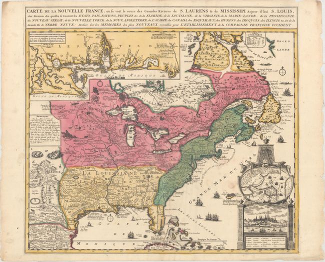
Auction 163, Lot 56
Subject: Colonial Eastern United States & Canada
Fer, Nicolas de
Carte de la Nouvelle France, ou se voit le Cours des Grandes Rivieres de S. Laurnes & de Mississipi Aujour d'hui S. Louis, aux Environs Des-quelles se Trouvent les Etats, Pais, Nations, Peuples, &c..., 1719
Size: 21.7 x 19.6 inches (55.1 x 49.8 cm)
Estimate: $2,300 - $2,750
Striking Map of French Colonial Possessions
Sold for: $1,700
Closed on 6/14/2017
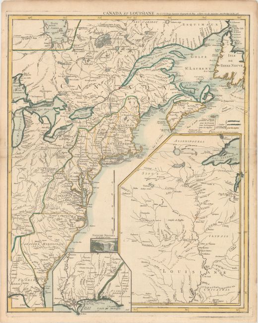
Auction 163, Lot 57
Subject: Colonial Eastern United States & Canada
Le Rouge, George Louis
Canada et Louisiane, 1755
Size: 19.6 x 24.3 inches (49.8 x 61.7 cm)
Estimate: $2,000 - $2,300
Uncommon French & Indian War Map
Sold for: $1,500
Closed on 6/14/2017
Auction 163, Lot 58
Subject: Colonial Eastern United States & Canada
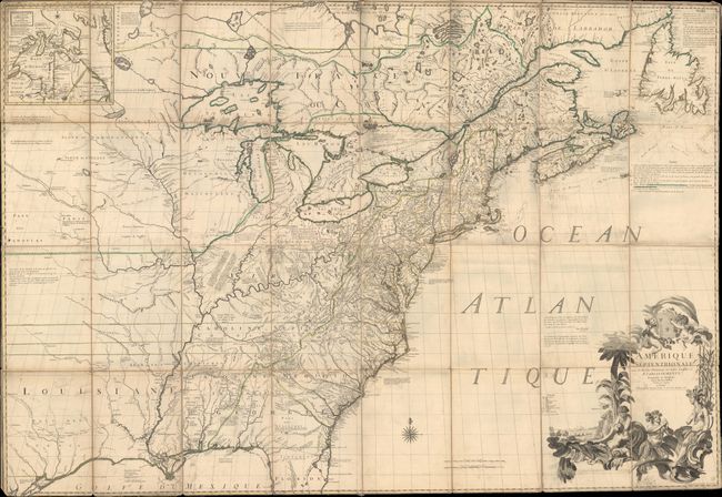
Mitchell/Le Rouge
Amerique Septentrionale avec les Routes, Distances en Miles, Limites et Etablissements Francois et Anglois..., 1756
Size: 76.1 x 53 inches (193.3 x 134.6 cm)
Estimate: $20,000 - $25,000
First French Edition of Mitchell's Monumental Map
Unsold
Closed on 6/14/2017
Auction 163, Lot 59
Subject: Colonial Eastern United States & Canada
Spilsbury, J.
A New Map of North America from the Latest Discoveries, 1761
Size: 14.9 x 10.8 inches (37.8 x 27.4 cm)
Estimate: $600 - $750
Sold for: $475
Closed on 6/14/2017
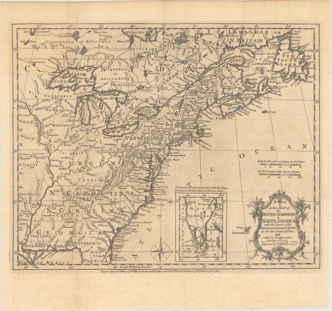
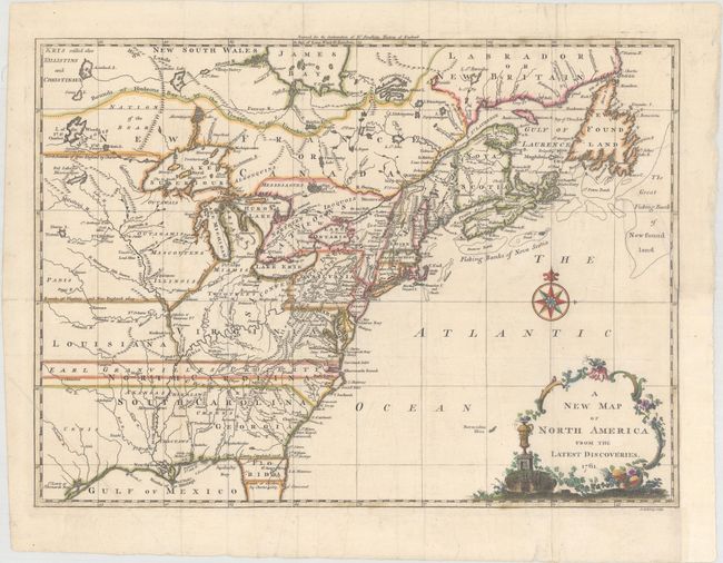
Auction 163, Lot 60
Subject: Colonial Eastern United States & Canada
Kitchin, Thomas
A New Map of the British Dominions in North America; with the Limits of the Governments Annexed Thereto by the Late Treaty of Peace, and Settled by Proclamation, October 7th 1763, 1763
Size: 11.9 x 9.6 inches (30.2 x 24.4 cm)
Estimate: $350 - $425
Sold for: $350
Closed on 6/14/2017
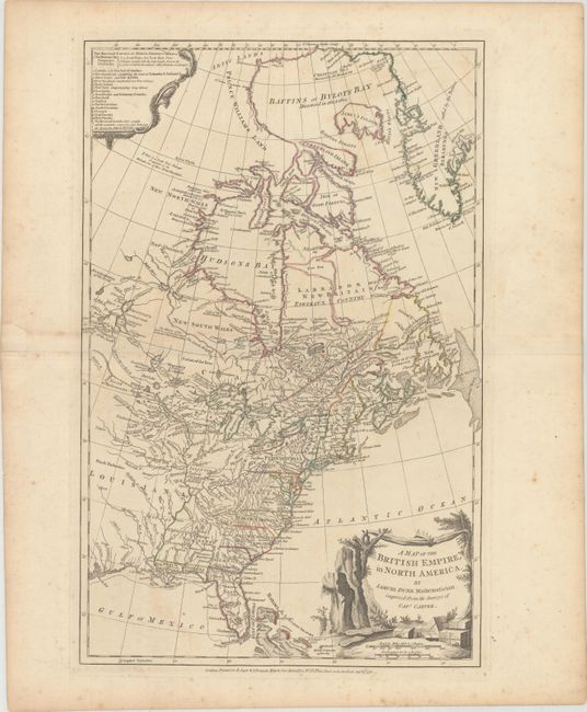
Auction 163, Lot 61
Subject: Colonial Eastern United States & Canada
Dunn, Samuel
A Map of the British Empire, in North America, 1776
Size: 12.1 x 18.8 inches (30.7 x 47.8 cm)
Estimate: $1,400 - $1,700
Unsold
Closed on 6/14/2017
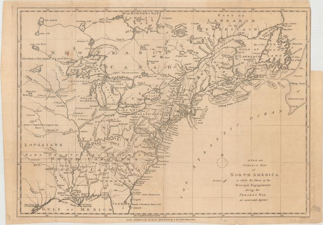
Auction 163, Lot 62
Subject: Colonial Eastern United States & Canada
Lodge, John
A New and Correct Map of North America in Which the Places of the Principal Engagements During the Present War, Are Accurately Inserted, 1780
Size: 15.1 x 10.9 inches (38.4 x 27.7 cm)
Estimate: $500 - $650
Sold for: $300
Closed on 6/14/2017
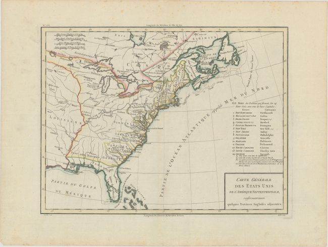
Auction 163, Lot 63
Subject: Eastern United States & Canada
Tardieu, Pierre Francois
Carte Generale des Etats Unis de l'Amerique Septentrionale, Renfermant Aussi Quelques Provinces Angloises Adjacentes, 1797
Size: 16.8 x 12.8 inches (42.7 x 32.5 cm)
Estimate: $350 - $450
Sold for: $200
Closed on 6/14/2017
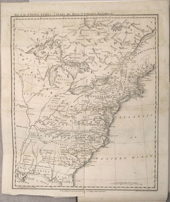
Auction 163, Lot 64
Subject: Eastern United States & Canada
Rochefoucald Liancourt, Francois Alexander
[4 Volumes] Travels Through the United States of North America, the Country of the Iroquois, and Upper Canada, in the Years 1795, 1796, and 1797, 1800
Size: 5.4 x 8.6 inches (13.7 x 21.8 cm)
Estimate: $3,000 - $4,000
Features Map Depicting Franklinia and Morgania
Sold for: $2,200
Closed on 6/14/2017
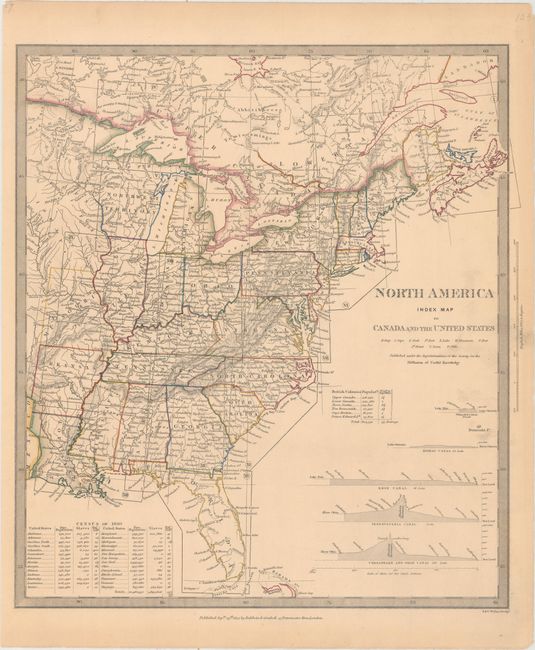
Auction 163, Lot 65
Subject: Eastern United States & Canada
SDUK Society for the Diffusion of Useful Knowledge
North America Index Map to Canada and the United States, 1834
Size: 12.8 x 14.3 inches (32.5 x 36.3 cm)
Estimate: $50 - $70
Sold for: $30
Closed on 6/14/2017
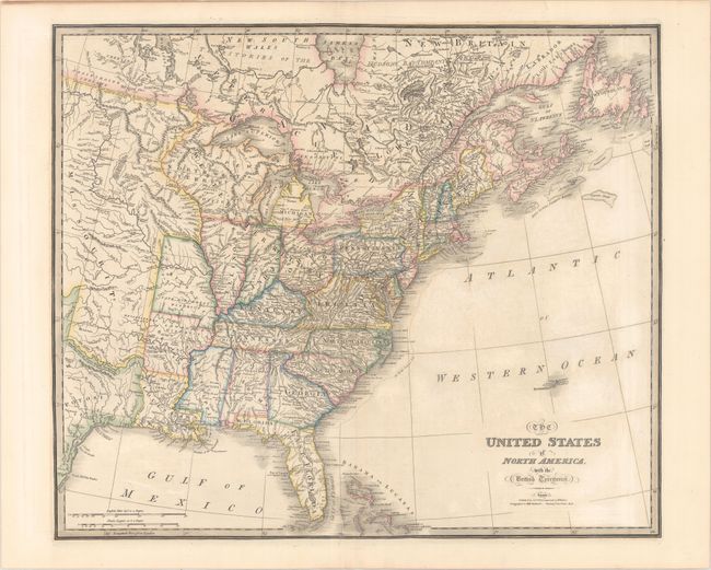
Auction 163, Lot 66
Subject: Eastern United States & Canada
Wyld, James
The United States of North America, with the British Territories, 1838
Size: 25 x 21.1 inches (63.5 x 53.6 cm)
Estimate: $475 - $600
Sold for: $300
Closed on 6/14/2017
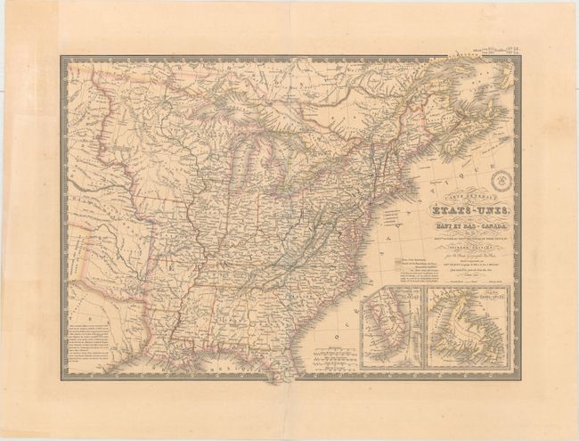
Auction 163, Lot 67
Subject: Eastern United States & Canada
Brue, Adrien Hubert
Carte Generale des Etats-Unis, des Haut et Bas-Canada, de la Nouvle. Ecosse, du Nouvau. Brunswick, de Terre-Neuve, &a. Seconde Edition, 1840
Size: 20.3 x 14.8 inches (51.6 x 37.6 cm)
Estimate: $180 - $220
Sold for: $130
Closed on 6/14/2017
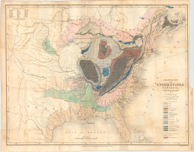
Auction 163, Lot 68
Subject: Eastern United States & Canada
Lyell, Charles
Geological Map of the United States Canada &c. Compiled from the State Surveys of the U.S. and Other Sources, 1845
Size: 19.7 x 15.2 inches (50 x 38.6 cm)
Estimate: $400 - $500
Sold for: $500
Closed on 6/14/2017
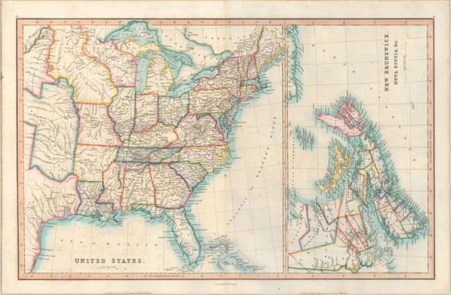
Auction 163, Lot 69
Subject: Eastern United States & Canada
Smith & Son
United States [on sheet with] New Brunswick, Nova Scotia &c., 1846
Size: 22.5 x 14.1 inches (57.2 x 35.8 cm)
Estimate: $170 - $200
Sold for: $110
Closed on 6/14/2017
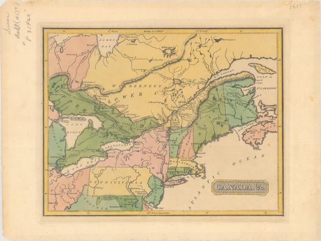
Auction 163, Lot 70
Subject: Northeastern United States & Canada
Lucas, Fielding
Canada, &c., 1816
Size: 10.6 x 8.4 inches (26.9 x 21.3 cm)
Estimate: $275 - $350
Unsold
Closed on 6/14/2017
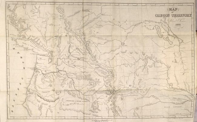
Auction 163, Lot 71
Subject: Western United States & Canada
Parker, Samuel (Rev.)
Journal of an Exploring Tour Beyond the Rocky Mountains … [with] Map of Oregon Territory, 1842
Size: 5 x 7.8 inches (12.7 x 19.8 cm)
Estimate: $400 - $500
Sold for: $400
Closed on 6/14/2017
26 lots