Filtered by Category:Canada(Show All Categories)
Showing results for:Auction 148
Catalog Archive
35 lots
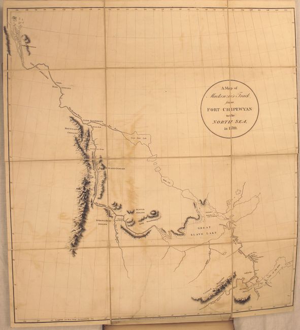
Auction 148, Lot 105
Subject: Canada
Mackenzie, Alexander
Voyages from Montreal, on the River St. Laurence, Through the Continent of North America, to the Frozen and Pacific Oceans; in the Years 1789 and 1793..., 1801
Size: 8.6 x 10.8 inches (21.8 x 27.4 cm)
Estimate: $5,500 - $6,500
First Edition of Mackenzie's Famous Account
Unsold
Closed on 2/19/2014
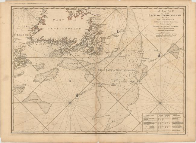
Auction 148, Lot 106
Subject: Eastern Canada
Jefferys/Sayer & Bennett
A Chart of the Banks of Newfoundland, Drawn from a Great Number of Hydrographical Surveys, Chiefly from Those of Chabert, Cook and Fleurieu, Connected and Ascertained by Astronomical Observations, 1775
Size: 26 x 19.5 inches (66 x 49.5 cm)
Estimate: $250 - $325
Sold for: $150
Closed on 2/19/2014
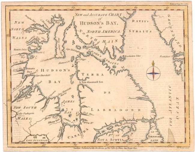
Auction 148, Lot 107
Subject: Eastern Canada
[Lot of 2] New and Accurate Chart of Hudson's Bay, in North America [and] Halifax Harbor, 1782-1865
Size: See Description
Estimate: $120 - $150
Unsold
Closed on 2/19/2014
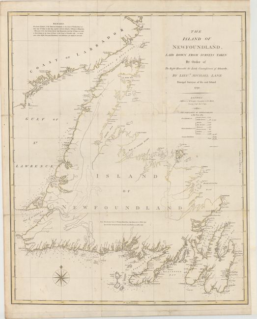
Auction 148, Lot 108
Subject: Eastern Canada
Faden, William
The Island of Newfoundland, Laid Down from Surveys Taken by Order of the Right Honorable the Lords Commissioners of Admiralty, by Lieut. Michael Lane..., 1790
Size: 22.8 x 28.1 inches (57.9 x 71.4 cm)
Estimate: $700 - $850
Unsold
Closed on 2/19/2014
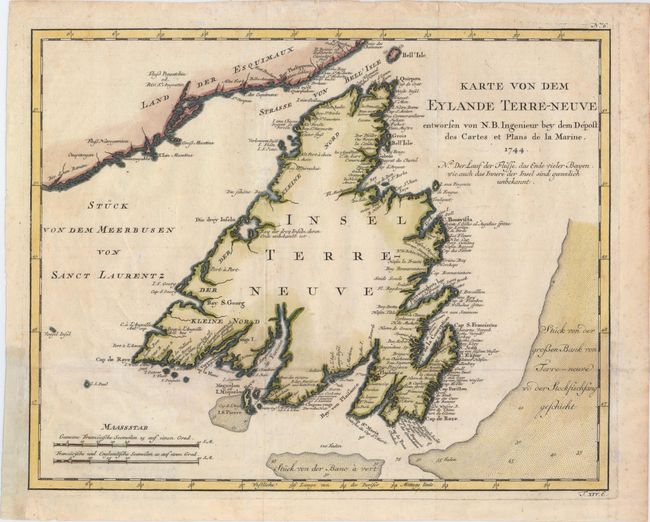
Auction 148, Lot 109
Subject: Newfoundland, Canada
Bellin, Jacques Nicolas
Karte von dem Eylande Terre-Neuve..., 1744
Size: 14.1 x 11.3 inches (35.8 x 28.7 cm)
Estimate: $140 - $170
Sold for: $170
Closed on 2/19/2014
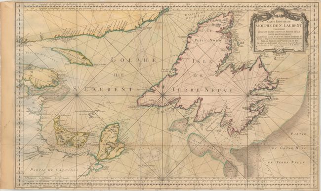
Auction 148, Lot 110
Subject: Gulf of St. Lawrence, Canada
Bellin, Jacques Nicolas
Carte Reduite du Golphe de St. Laurent Contenant l'Isle de Terre-Neuve et Partie de la Coste des Esquimaux..., 1754
Size: 33.8 x 20.9 inches (85.9 x 53.1 cm)
Estimate: $275 - $350
Sold for: $180
Closed on 2/19/2014
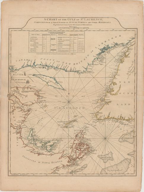
Auction 148, Lot 111
Subject: Gulf of St. Lawrence, Canada
Jefferys/Sayer & Bennett
A Chart of the Gulf of St. Laurence, Composed from a Great Number of Actual Surveys and Other Materials, Regulated and Connected by Astronomical Observations, 1775
Size: 19.6 x 24.1 inches (49.8 x 61.2 cm)
Estimate: $450 - $550
Unsold
Closed on 2/19/2014

Auction 148, Lot 112
Subject: St. Lawrence River, Canada
Bellin, Jacques Nicolas
Karte von dem Laufe des Flusses St. Laurenz..., 1757
Size: 11.9 x 7.6 inches (30.2 x 19.3 cm)
Estimate: $120 - $150
Sold for: $90
Closed on 2/19/2014
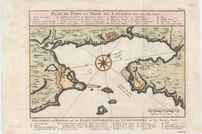
Auction 148, Lot 113
Subject: Cape Breton Island, Canada
Bellin, Jacques Nicolas
Plan du Port et Ville de Louisbourg dans l'Isle Royale, 1756
Size: 11.1 x 7.6 inches (28.2 x 19.3 cm)
Estimate: $160 - $200
Sold for: $110
Closed on 2/19/2014
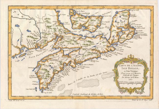
Auction 148, Lot 114
Subject: Nova Scotia, Canada
Bellin, Jacques Nicolas
Carte de l'Acadie, Isle Royale, et Pais Voisins. Pour Servir a l'Histoire Generale des Voyages, 1757
Size: 13 x 8.4 inches (33 x 21.3 cm)
Estimate: $160 - $190
Sold for: $150
Closed on 2/19/2014
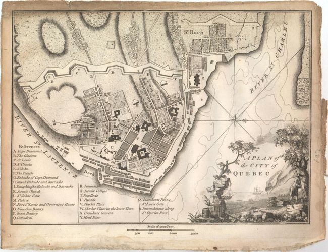
Auction 148, Lot 115
Subject: Quebec City, Canada
Weld, Isaac
A Plan of the City of Quebec, 1798
Size: 9.5 x 6.8 inches (24.1 x 17.3 cm)
Estimate: $140 - $170
Unsold
Closed on 2/19/2014
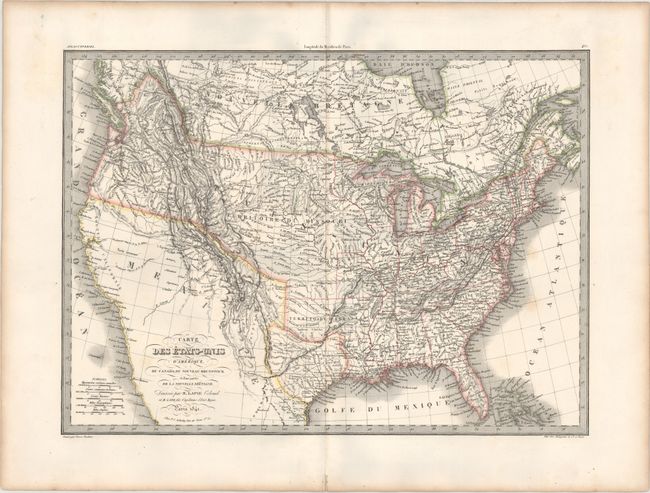
Auction 148, Lot 116
Subject: United States & Canada, Texas
Lapie/Tardieu
Carte des Etats-Unis d'Amerique, du Canada, du Nouveau Brunswick et d'une Partie de la Nouvelle Bretagne, 1841
Size: 21.5 x 15.7 inches (54.6 x 39.9 cm)
Estimate: $300 - $400
Sold for: $220
Closed on 2/19/2014
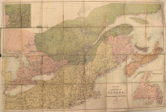
Auction 148, Lot 117
Subject: United States & Canada
Bartholomew, John
New Map of the Dominion of Canada, 1870
Size: 32.6 x 21.3 inches (82.8 x 54.1 cm)
Estimate: $80 - $100
Sold for: $60
Closed on 2/19/2014
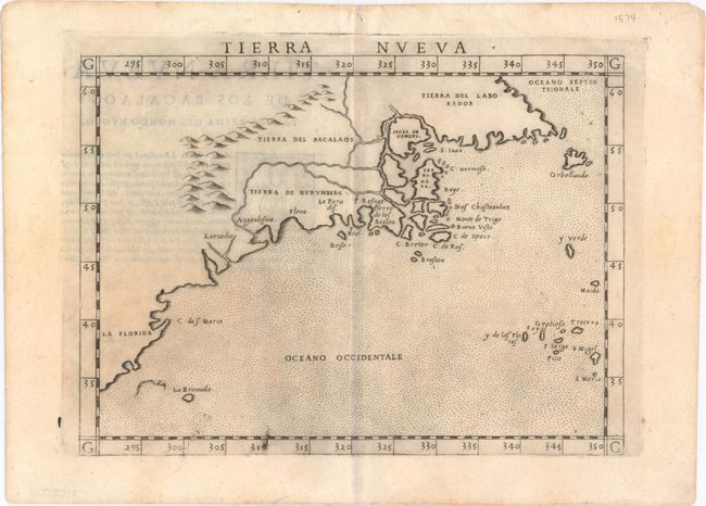
Auction 148, Lot 118
Subject: Eastern United States & Canada
Ruscelli, Girolamo
Tierra Nueva, 1574
Size: 9.6 x 7.3 inches (24.4 x 18.5 cm)
Estimate: $1,000 - $1,300
Sold for: $500
Closed on 2/19/2014
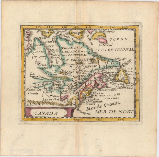
Auction 148, Lot 119
Subject: Colonial United States & Canada
Duval, Pierre
Canada, 1682
Size: 4.8 x 3.9 inches (12.2 x 9.9 cm)
Estimate: $400 - $500
Sold for: $300
Closed on 2/19/2014
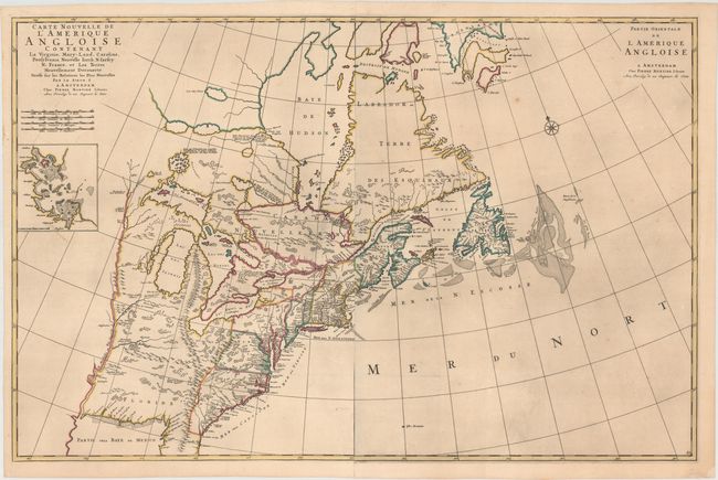
Auction 148, Lot 120
Subject: Colonial United States & Canada
Mortier, Pierre
Carte Nouvelle de l'Amerique Angloise Contenant la Virginie, Mary-Land, Caroline, Pensylvania, Nouvelle Iorck, N: Iarsey N: France, et les Terres Nouvellement Decouerte..., 1700
Size: 36 x 23.5 inches (91.4 x 59.7 cm)
Estimate: $3,500 - $4,250
A Map Showing Fascinating Geographic Misconceptions
Unsold
Closed on 2/19/2014
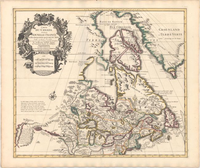
Auction 148, Lot 121
Subject: Colonial United States & Canada
Delisle/Covens & Mortier
Carte du Canada ou de la Nouvelle France et des Decouvertes qui y ont ete Faites..., 1730
Size: 22.6 x 19.3 inches (57.4 x 49 cm)
Estimate: $1,400 - $1,700
One of the Most Influential Maps of Canada, the Great Lakes and Upper Midwest
Sold for: $1,100
Closed on 2/19/2014
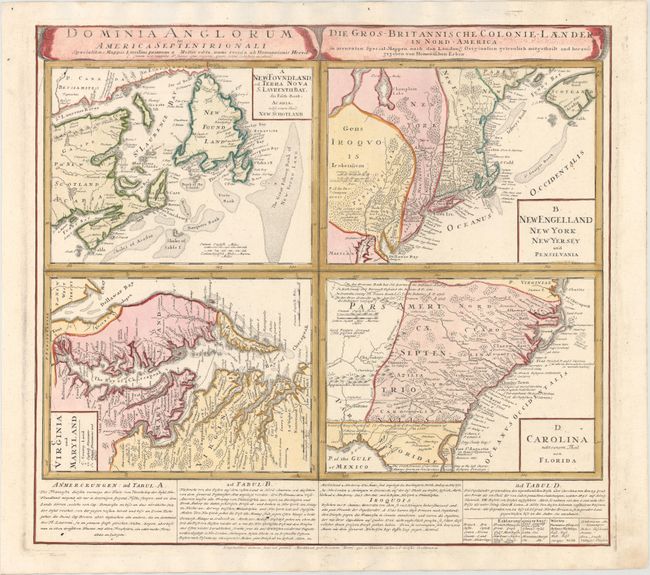
Auction 148, Lot 122
Subject: Colonial United States & Canada
Homann Heirs
Dominia Anglorum in America Septentrionali... / Die Gros-Britannische Colonie-Laender, in Nord-America..., 1740
Size: 22.1 x 19.9 inches (56.1 x 50.5 cm)
Estimate: $550 - $700
Sold for: $350
Closed on 2/19/2014
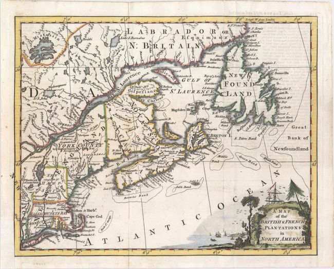
Auction 148, Lot 123
Subject: Colonial United States & Canada
Anon.
A Map of the British & French Plantations in North America, 1755
Size: 10.4 x 8.3 inches (26.4 x 21.1 cm)
Estimate: $250 - $325
Sold for: $180
Closed on 2/19/2014
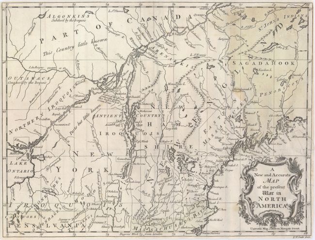
Auction 148, Lot 124
Subject: Colonial United States & Canada
Hinton, John
A New and Accurate Map of the Present War in North America, 1757
Size: 14.3 x 10.8 inches (36.3 x 27.4 cm)
Estimate: $450 - $550
Sold for: $375
Closed on 2/19/2014
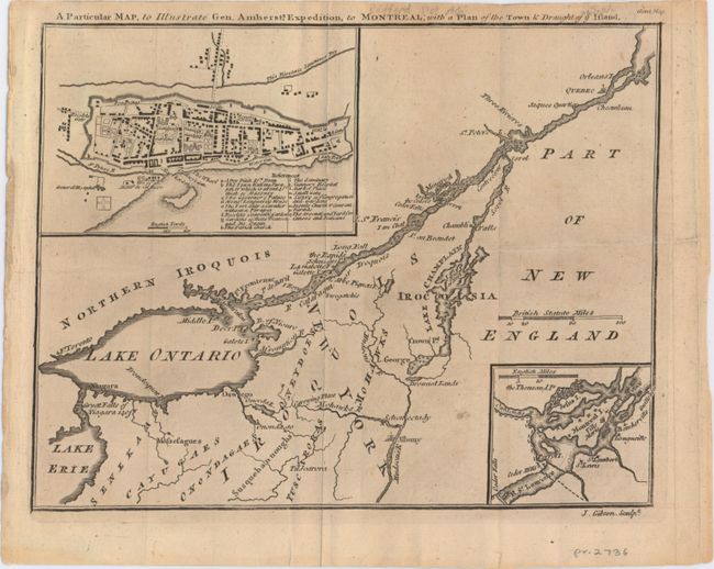
Auction 148, Lot 125
Subject: Colonial United States & Canada
Gibson, John
A Particular Map, to Illustrate Gen. Amherst's Expedition, to Montreal; with a Plan of the Town & Draught of ye Island, 1760
Size: 9 x 7.2 inches (22.9 x 18.3 cm)
Estimate: $140 - $180
Sold for: $80
Closed on 2/19/2014
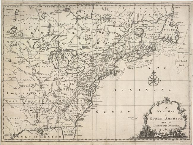
Auction 148, Lot 126
Subject: Colonial United States & Canada
Spilsbury, J.
A New Map of North America from the Latest Discoveries, 1761
Size: 14.9 x 10.9 inches (37.8 x 27.7 cm)
Estimate: $375 - $475
Sold for: $275
Closed on 2/19/2014
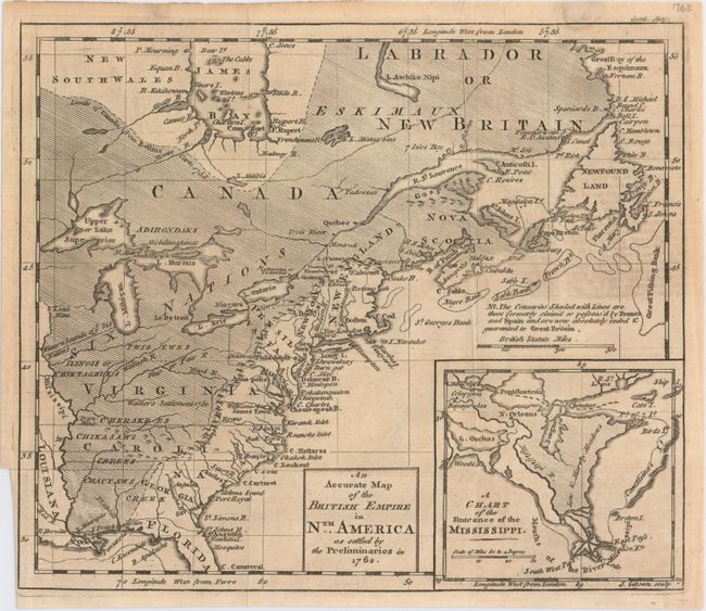
Auction 148, Lot 127
Subject: Colonial United States & Canada
Gibson, John
An Accurate Map of the British Empire in Nth. America as Settled by the Preliminaries in 1762, 1762
Size: 9.7 x 8.3 inches (24.6 x 21.1 cm)
Estimate: $240 - $300
Sold for: $180
Closed on 2/19/2014
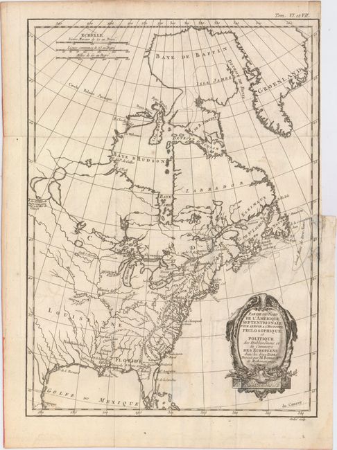
Auction 148, Lot 128
Subject: Colonial United States & Canada
Bonne, Rigobert
Partie du Nord de l'Amerique Septentrionale, pour Servir a l'Histoire Philosophique et Politique…, 1774
Size: 9.3 x 12.6 inches (23.6 x 32 cm)
Estimate: $200 - $250
Sold for: $110
Closed on 2/19/2014
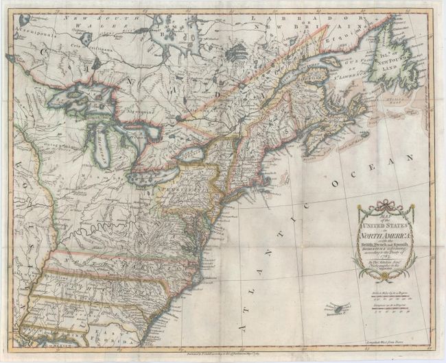
Auction 148, Lot 129
Subject: Eastern United States & Canada
Kitchin, Thomas
Map of the United States in North America: with the British, French and Spanish Dominions Adjoining, According to the Treaty of 1783, 1783
Size: 19.7 x 16 inches (50 x 40.6 cm)
Estimate: $1,000 - $1,400
Sold for: $2,100
Closed on 2/19/2014
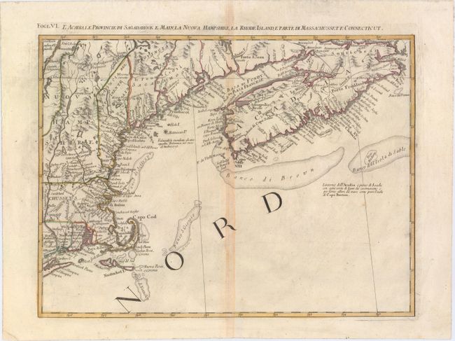
Auction 148, Lot 130
Subject: Eastern United States & Canada
Zatta, Antonio
L'Acadia, le Provincie di Sagadahook e Main, la Nuova Hampshire, la Rhode Island, e Parte di Massachusset e Connecticut, 1785
Size: 16.7 x 12.5 inches (42.4 x 31.8 cm)
Estimate: $275 - $350
Sold for: $160
Closed on 2/19/2014
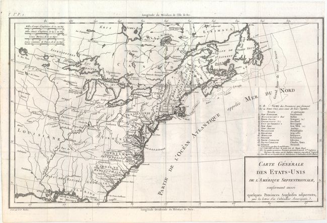
Auction 148, Lot 131
Subject: Eastern United States & Canada
Crevecoeur, Michel Guillaume De
Carte Generale des Etats-Unis de l'Amerique Septentrionale, Renfermant Aussi Quelques Provinces Angloises Adjacentes..., 1787
Size: 16.7 x 10.1 inches (42.4 x 25.7 cm)
Estimate: $600 - $800
First Printed Map to Name Franklinia
Sold for: $1,000
Closed on 2/19/2014
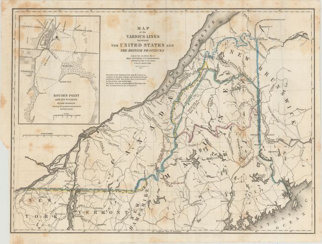
Auction 148, Lot 132
Subject: Eastern United States & Canada
Graham, James D.
[Map with Report] Map of the Various Lines between the United States and the British Provinces, 1846
Size: 15.5 x 11.8 inches (39.4 x 30 cm)
Estimate: $400 - $500
Sold for: $300
Closed on 2/19/2014
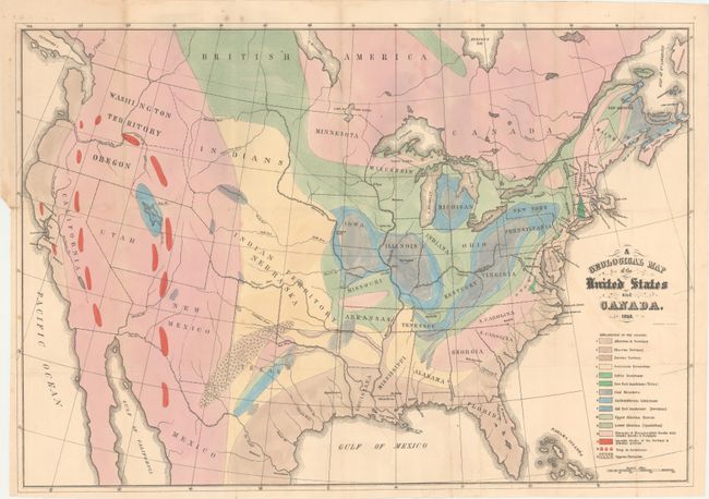
Auction 148, Lot 133
Subject: Eastern United States & Canada
Hitchcock, Edward
A Geological Map of the United States and Canada, 1853
Size: 24.4 x 16.7 inches (62 x 42.4 cm)
Estimate: $700 - $900
Sold for: $350
Closed on 2/19/2014
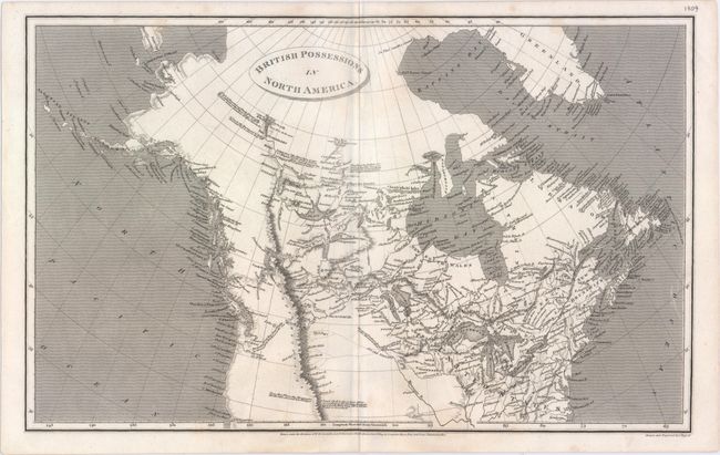
Auction 148, Lot 134
Subject: Northern United States & Canada
Arrowsmith, Aaron, Sr.
British Possessions in North America, 1809
Size: 15.6 x 10.8 inches (39.6 x 27.4 cm)
Estimate: $200 - $230
Sold for: $140
Closed on 2/19/2014
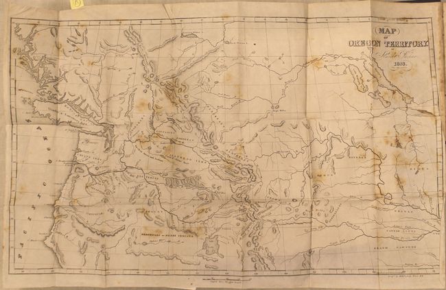
Auction 148, Lot 135
Subject: Western United States & Canada
Parker, Samuel (Rev.)
Journal of an Exploring Tour Beyond the Rocky Mountains … [with] Map of Oregon Territory, 1844
Size: 5 x 7.8 inches (12.7 x 19.8 cm)
Estimate: $700 - $850
Unsold
Closed on 2/19/2014
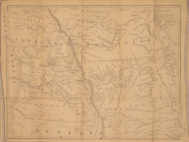
Auction 148, Lot 136
Subject: Western United States & Canada
De Smet, Father Pierre-Jean
Voyages Aux Montagnes Rocheuses, et une Annee de Sejour Chez les Tribus Indiennes du Vaste Territoire de l'Oregon, Defendant des Etats-Unis d'Amerique, 1844
Size: 15.5 x 12 inches (39.4 x 30.5 cm)
Estimate: $500 - $700
Sold for: $350
Closed on 2/19/2014
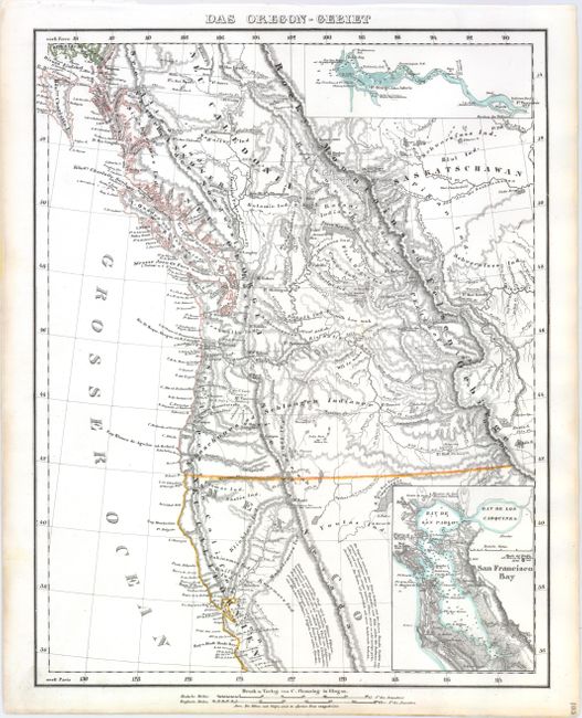
Auction 148, Lot 137
Subject: Western United States & Canada
Flemming, Carl
Das Oregon-Gebiet, 1848
Size: 12.6 x 16.4 inches (32 x 41.7 cm)
Estimate: $275 - $350
Unsold
Closed on 2/19/2014
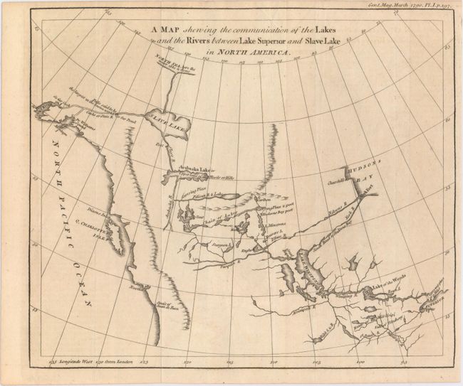
Auction 148, Lot 138
Subject: Western Canada & Alaska
Anon.
A Map Shewing the Communication of the Lakes and the Rivers Between Lake Superior and Slave Lake in North America, 1790
Size: 9.3 x 7.8 inches (23.6 x 19.8 cm)
Estimate: $275 - $350
Sold for: $180
Closed on 2/19/2014
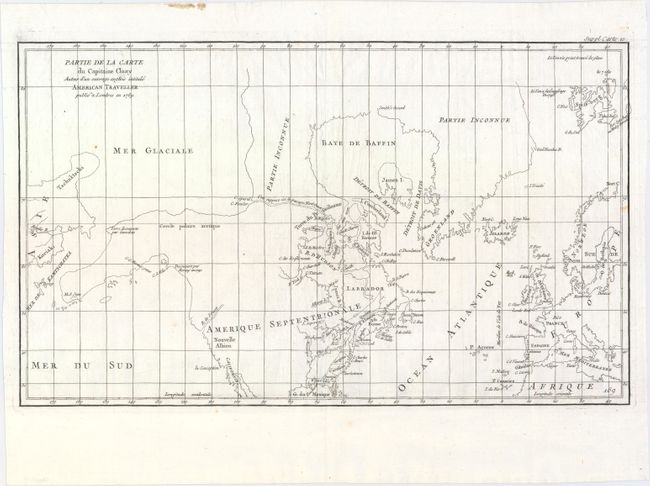
Auction 148, Lot 139
Subject: Arctic, Canada & Alaska
Robert de Vaugondy, Didier
Partie de la Carte du Capitaine Cluny Auteur d'un Ouvrage Anglois Intitule American Traveller Publie a ' Londres en 1769, 1769
Size: 19.4 x 11.6 inches (49.3 x 29.5 cm)
Estimate: $150 - $190
Sold for: $90
Closed on 2/19/2014
35 lots