Filtered by Category:Canada(Show All Categories)
Showing results for:Auction 146
Catalog Archive
19 lots
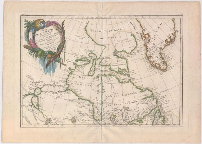
Auction 146, Lot 115
Subject: Canada
Bonne/Lattre
Partie de l'Amerique Septentrionale, qui Comprend le Canada..., 1783
Size: 17.1 x 11.8 inches (43.4 x 30 cm)
Estimate: $200 - $230
Sold for: $130
Closed on 9/4/2013
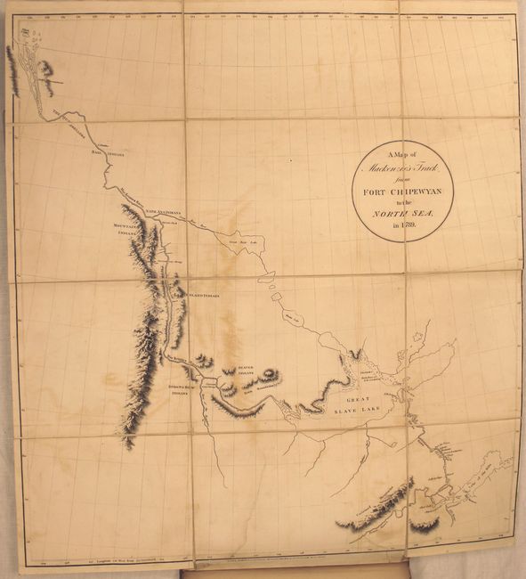
Auction 146, Lot 116
Subject: Canada
Mackenzie, Alexander
Voyages from Montreal, on the River St. Laurence, Through the Continent of North America, to the Frozen and Pacific Oceans; in the Years 1789 and 1793..., 1801
Size: 8.6 x 10.8 inches (21.8 x 27.4 cm)
Estimate: $6,000 - $7,000
First Edition of Mackenzie's Famous Account
Unsold
Closed on 9/4/2013
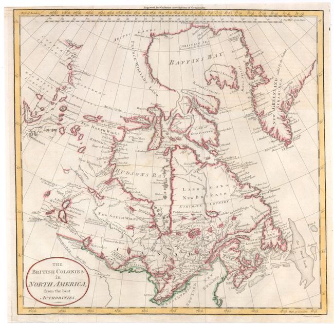
Auction 146, Lot 117
Subject: Eastern Canada
Guthrie, William
The British Colonies in North America, from the Best Authorities, 1795
Size: 13.3 x 13.2 inches (33.8 x 33.5 cm)
Estimate: $130 - $160
Sold for: $95
Closed on 9/4/2013
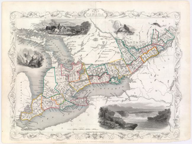
Auction 146, Lot 118
Subject: Eastern Canada
Tallis, John
West Canada, 1851
Size: 13 x 9.8 inches (33 x 24.9 cm)
Estimate: $120 - $150
Sold for: $70
Closed on 9/4/2013
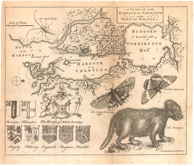
Auction 146, Lot 119
Subject: Halifax, Canada
A Plan of the Harbour of Chebucto and Town of Halifax, 1750
Size: 10.8 x 8.8 inches (27.4 x 22.4 cm)
Estimate: $700 - $850
The Porcupine Map
Sold for: $500
Closed on 9/4/2013
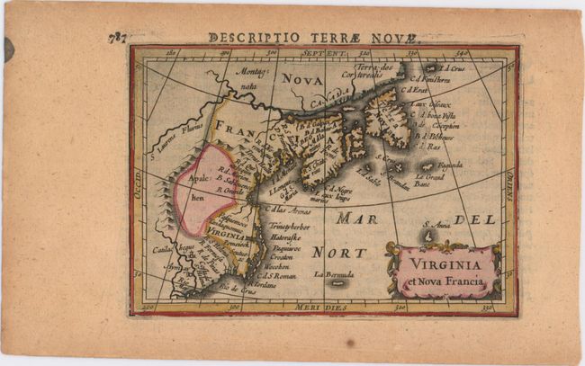
Auction 146, Lot 120
Subject: Colonial United States & Canada
Hondius/Bertius
Virginia et Nova Francia, 1618
Size: 5.4 x 3.8 inches (13.7 x 9.7 cm)
Estimate: $600 - $750
Sold for: $400
Closed on 9/4/2013
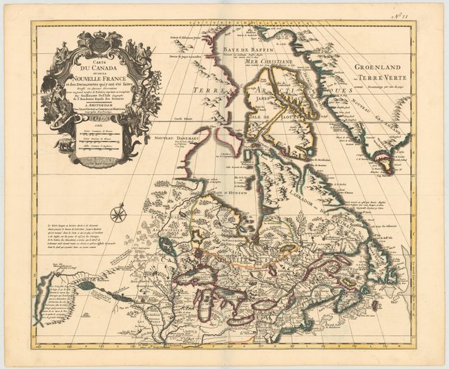
Auction 146, Lot 121
Subject: Colonial United States & Canada
Delisle/Covens & Mortier
Carte du Canada ou de la Nouvelle France et des Decouvertes quiy ont ete Faites..., 1730
Size: 22.6 x 19.3 inches (57.4 x 49 cm)
Estimate: $1,400 - $1,700
One of the most influential maps of Canada, the Great Lakes and Upper Midwest
Sold for: $1,300
Closed on 9/4/2013
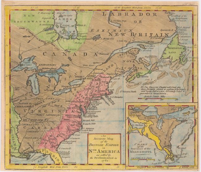
Auction 146, Lot 122
Subject: Colonial United States & Canada
Gibson, John
An Accurate Map of the British Empire in Nth. America as Settled by the Preliminaries in 1762, 1762
Size: 9.7 x 8.3 inches (24.6 x 21.1 cm)
Estimate: $300 - $400
Sold for: $220
Closed on 9/4/2013
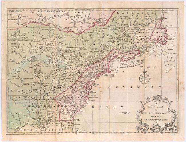
Auction 146, Lot 123
Subject: Colonial United States & Canada
Spilsbury, J.
A New Map of North America from the Latest Discoveries, 1763
Size: 14.75 x 10.9 inches (37.5 x 27.7 cm)
Estimate: $275 - $350
Unsold
Closed on 9/4/2013
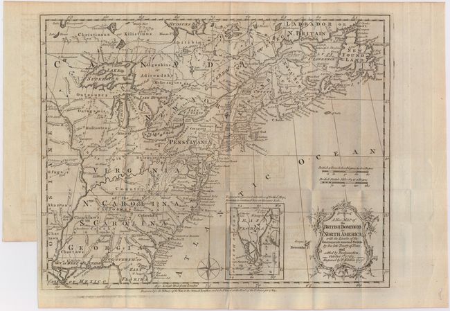
Auction 146, Lot 124
Subject: Colonial United States & Canada
Kitchin, Thomas
A New Map of the British Dominions in North America; with the Limits of the Governments Annexed thereto by the Late Treaty of Peace, and Settled by Proclamation, October 7th, 1763, 1763
Size: 12 x 9.5 inches (30.5 x 24.1 cm)
Estimate: $500 - $600
Sold for: $250
Closed on 9/4/2013
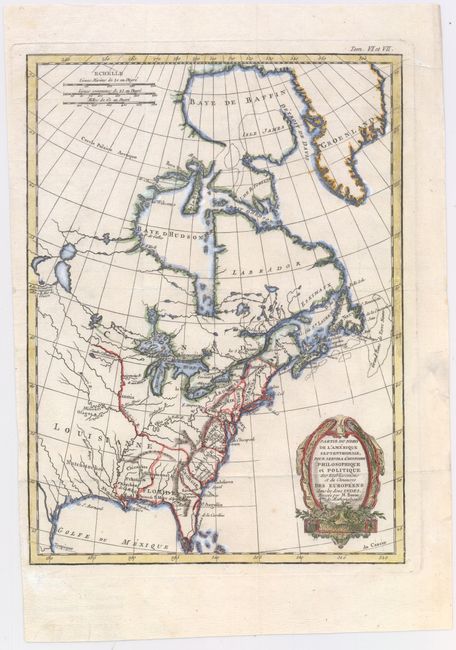
Auction 146, Lot 125
Subject: Colonial United States & Canada
Bonne, Rigobert
Partie du Nord de l'Amerique Septentrionale, pour Servir a l'Histoire Philosophique et Politique…, 1774
Size: 9.3 x 12.6 inches (23.6 x 32 cm)
Estimate: $240 - $300
Unsold
Closed on 9/4/2013
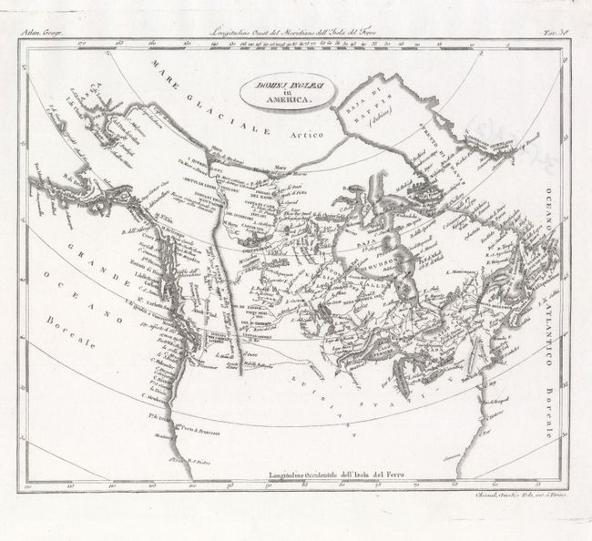
Auction 146, Lot 126
Subject: United States & Canada
Barbiellini, Carlo Antonio
Dominj Inglesi in America, 1807
Size: 9.7 x 7.9 inches (24.6 x 20.1 cm)
Estimate: $150 - $180
Sold for: $130
Closed on 9/4/2013
Auction 146, Lot 127
Subject: Eastern United States & Canada
Gordon, William
A New Map of the States of Pensylvania New Jersey New York Connecticut Rhode Island Massachusets and New Hampshire Including Nova Scotia and Canada..., 1789
Size: 16 x 10.6 inches (40.6 x 26.9 cm)
Estimate: $240 - $300
Unsold
Closed on 9/4/2013
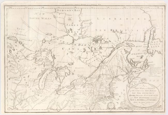
Auction 146, Lot 128
Subject: Eastern United States & Canada
Stockdale, John
A Map of the Northern & Middle States; Comprehending the Western Territory and the British Dominions in North America. From the Best Authorities, 1792
Size: 15.7 x 12.5 inches (39.9 x 31.8 cm)
Estimate: $650 - $800
Unsold
Closed on 9/4/2013
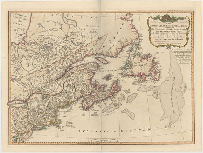
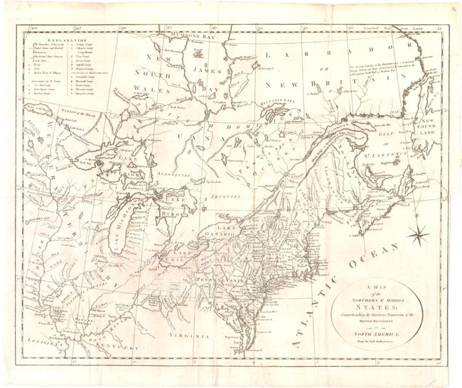
Auction 146, Lot 129
Subject: Eastern United States & Canada
Laurie & Whittle
A New and Correct Map of the British Colonies in North America Comprehending Eastern Canada with the Province of Quebec, New Brunswick, Nova Scotia, ... Newfoundland: with the Adjacent States of New England, Vermont, New York, Pennsylvania and New Jersey, 1794
Size: 25.8 x 18.5 inches (65.5 x 47 cm)
Estimate: $600 - $750
Unsold
Closed on 9/4/2013
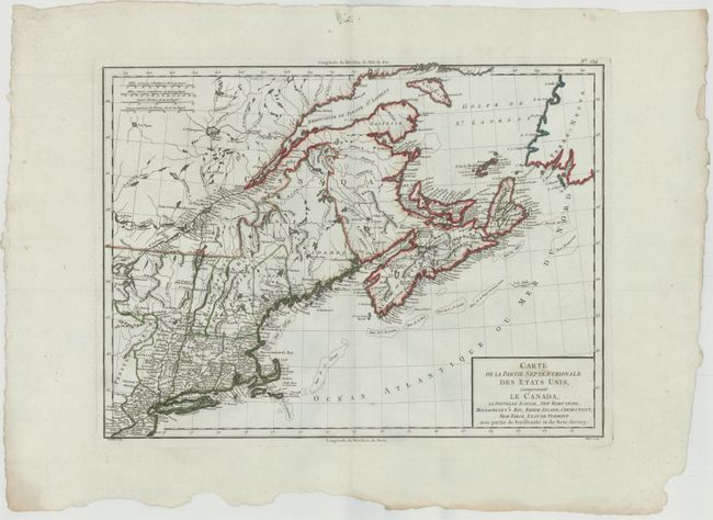
Auction 146, Lot 130
Subject: Eastern United States & Canada
Tardieu, Pierre Francois
Carte de la Partie Septentrionale des Etats Unis, comprenant le Canada, La Nouvelle Ecosse, New Hampshire, Massachuset's Bay, Rhode-Island, Connecticut, New-Yorck, Etat de Vermont avec partie de Pensilvanie et de New-Jersey, 1797
Size: 16.8 x 12.5 inches (42.7 x 31.8 cm)
Estimate: $250 - $325
Sold for: $180
Closed on 9/4/2013
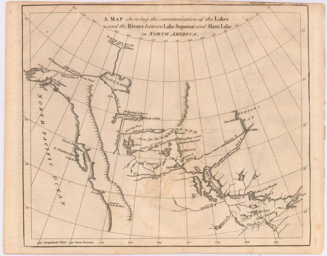
Auction 146, Lot 131
Subject: Western Canada & Alaska
Anon.
A Map Shewing the Communication of the Lakes and the Rivers Between Lake Superior and Slave Lake in North America, 1790
Size: 9.3 x 7.8 inches (23.6 x 19.8 cm)
Estimate: $275 - $350
Sold for: $150
Closed on 9/4/2013
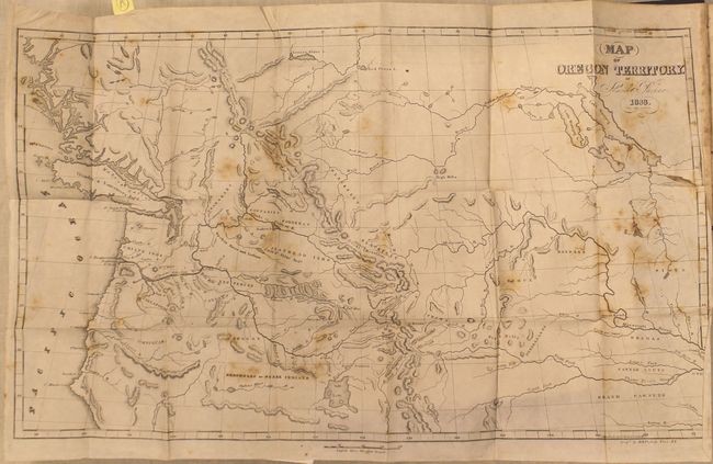
Auction 146, Lot 132
Subject: Western United States & Canada
Parker, Samuel (Rev.)
Journal of an Exploring Tour Beyond the Rocky Mountains … [with] Map of Oregon Territory, 1844
Size: 5 x 7.8 inches (12.7 x 19.8 cm)
Estimate: $700 - $850
Unsold
Closed on 9/4/2013
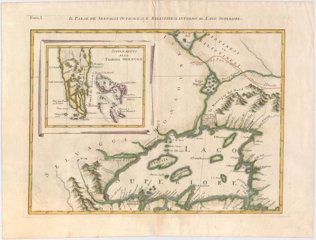
Auction 146, Lot 133
Subject: Great Lakes, Florida
Zatta, Antonio
Il Paese de Selvaggi Outauacesi e Kilistinesi Intorno al Lago Superiore, 1785
Size: 16.8 x 12.2 inches (42.7 x 31 cm)
Estimate: $400 - $475
Sold for: $300
Closed on 9/4/2013
19 lots