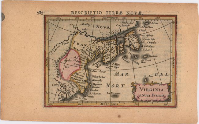
Subject: Colonial United States & Canada
Period: 1618 (published)
Publication: Tabularum Geographicarum Contractarum
Color: Hand Color
Size:
5.4 x 3.8 inches
13.7 x 9.7 cm
This charming miniature map depicts the east coast of North America from the Rio May to Newfoundland. The map is based on Hondius' world map from 1611, but does not incorporate new information from the explorations of Samuel de Champlain (in Canada and along the Great Lakes) or of John Smith (in the Chesapeake Bay area and New England). The area from present-day New York to Maine is labeled Norenbega, and the area further south is labeled Virginia, with the Chesapeake Bay noticeably missing. A region just east of a large mountain range (the Appalachian mountains) is named Apalc: hen, and the St. Lawrence river is featured prominently at top. Several small islands grace the Atlantic, including La Bermuda and S. Anna. Latin text on verso.
References: Burden #185; King (2nd ed.) pp. 96-99; Cumming #31; Kershaw #51.
Condition: B+
Attractive color with light, overall toning.