Filtered by Category:Canada(Show All Categories)
Showing results for:Auction 126
Catalog Archive
26 lots
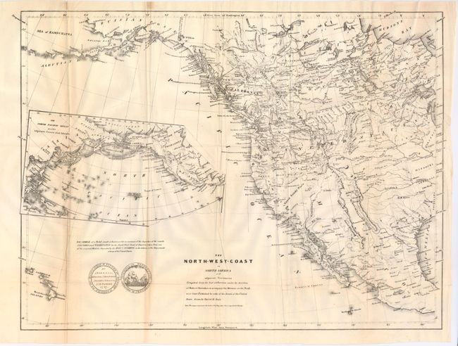
Auction 126, Lot 107
Subject: Western North America, Texas
Burr, David H.
The North-West-Coast of North America and Adjacent Territories…, 1840
Size: 21.3 x 16 inches (54.1 x 40.6 cm)
Estimate: $250 - $350
Sold for: $190
Closed on 12/3/2008
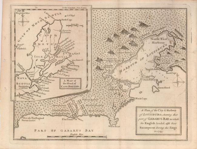
Auction 126, Lot 108
Subject: Canada
Anon.
A Plan of the City & Harbour of Louisburg; shewing that part of Gabarus Bay in which the English landed, also their Encampment during the Siege in 1745, 1758
Size: 10 x 7.5 inches (25.4 x 19.1 cm)
Estimate: $140 - $160
Sold for: $70
Closed on 12/3/2008
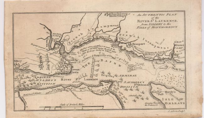
Auction 126, Lot 109
Subject: Canada
Gibson, John
An Authentic Plan of the River St. Laurence, from Sillery to the Falls of Montmorency, 1759
Size: 7.3 x 4 inches (18.5 x 10.2 cm)
Estimate: $160 - $200
Sold for: $120
Closed on 12/3/2008
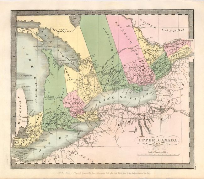
Auction 126, Lot 110
Subject: Canada
Burr/Illman
Upper Canada, 1833
Size: 12.3 x 10.6 inches (31.2 x 26.9 cm)
Estimate: $100 - $130
Sold for: $50
Closed on 12/3/2008
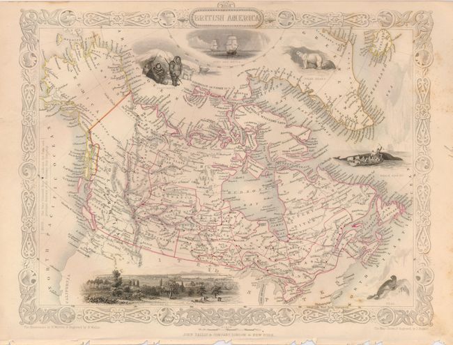
Auction 126, Lot 111
Subject: Canada
Tallis, John
[Lot of 2] British America [and] East Canada, and New Brunswick, 1860
Size: 12.5 x 9.5 inches (31.8 x 24.1 cm)
Estimate: $200 - $250
Sold for: $150
Closed on 12/3/2008
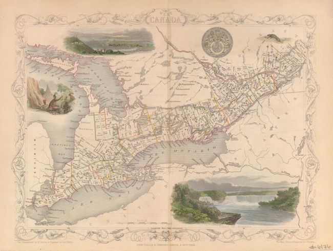
Auction 126, Lot 112
Subject: Canada
Tallis, John
[Lot of 2] West Canada [and] East Canada, and New Brunswick, 1860
Size: 12.5 x 9.5 inches (31.8 x 24.1 cm)
Estimate: $180 - $240
Sold for: $130
Closed on 12/3/2008
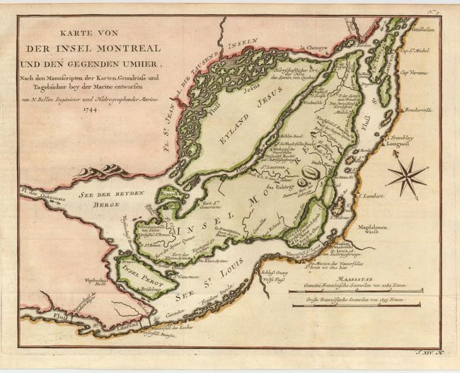
Auction 126, Lot 113
Subject: Canada, Montreal
Bellin, Jacques Nicolas
Karte von der Insel Montreal und den Gegenden Umher…, 1744
Size: 12.2 x 9.5 inches (31 x 24.1 cm)
Estimate: $160 - $200
Sold for: $120
Closed on 12/3/2008
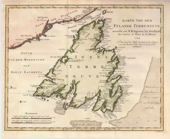
Auction 126, Lot 114
Subject: Canada, Newfoundland
Bellin, Jacques Nicolas
[Lot of 2] Karte von dem Eylande Terre-Neuve… [and] Karte von den Bayen, Rheeden und Hafen von Plaisance aus der Insel Terre Neuve, 1744
Size: See Description
Estimate: $240 - $300
Sold for: $180
Closed on 12/3/2008
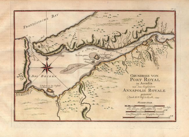
Auction 126, Lot 115
Subject: Canada, Nova Scotia
Bellin, Jacques Nicolas
[Lot of 3] Grundriss von Port Royal in Accadia… [and] Grundriss des Hafens la Haive an der Kuste von Accadien [and] Grundriss von der Bay Chedabuctu heutiges Tages Havre de Milfort, 1744
Size: See Description
Estimate: $350 - $400
Sold for: $250
Closed on 12/3/2008
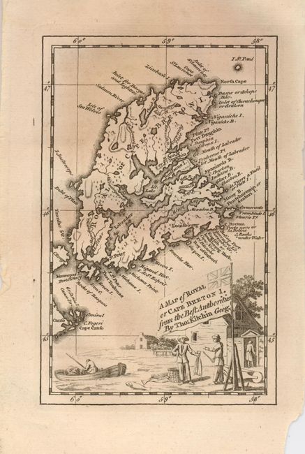
Auction 126, Lot 116
Subject: Canada, Nova Scotia
Kitchin, Thomas
A Map of Royal or Cape Breton I. From the Best Authorities, 1747
Size: 4 x 6.4 inches (10.2 x 16.3 cm)
Estimate: $100 - $140
Sold for: $75
Closed on 12/3/2008
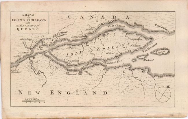
Auction 126, Lot 117
Subject: Canada, Quebec
Anon.
A Map of the Island of Orleans with the Environs of Quebec, 1759
Size: 7.3 x 4.3 inches (18.5 x 10.9 cm)
Estimate: $150 - $200
Unsold
Closed on 12/3/2008
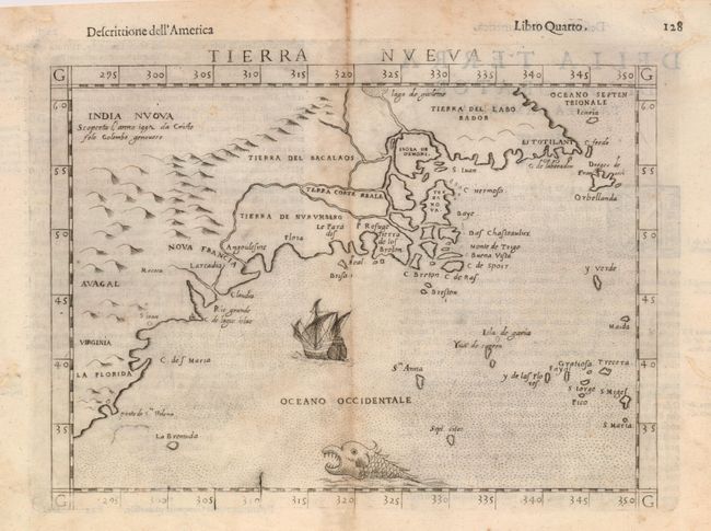
Auction 126, Lot 118
Subject: Colonial United States & Canada
Ruscelli, Girolamo
Tierra Nueva, 1598
Size: 9.7 x 7 inches (24.6 x 17.8 cm)
Estimate: $900 - $1,100
Sold for: $900
Closed on 12/3/2008
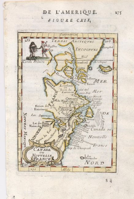
Auction 126, Lot 119
Subject: Colonial United States and Canada
Mallet, Alain Manesson
Canada ou Nouvelle France, 1683
Size: 4 x 5.5 inches (10.2 x 14 cm)
Estimate: $200 - $250
Sold for: $210
Closed on 12/3/2008
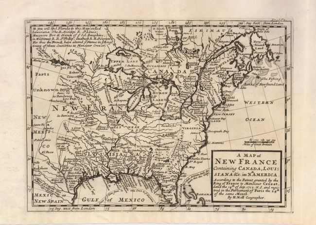
Auction 126, Lot 120
Subject: Colonial United States and Canada
Moll, Herman
A Map of New France Containing Canada, Louisiana &c. in Nth. America According to the Patent granted by the King of France to Monsieur Crozat, dated the 14th of Sep. 1712 N.S. and registered in the Parliament of Paris the 24th of the same Month, 1717
Size: 10 x 7.3 inches (25.4 x 18.5 cm)
Estimate: $600 - $700
Sold for: $450
Closed on 12/3/2008
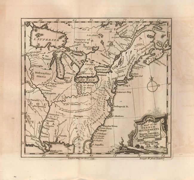
Auction 126, Lot 121
Subject: Colonial United States and Canada
Kitchin, Thomas
A Map of the French Settlements in North America, 1747
Size: 7 x 6.5 inches (17.8 x 16.5 cm)
Estimate: $200 - $250
Sold for: $130
Closed on 12/3/2008
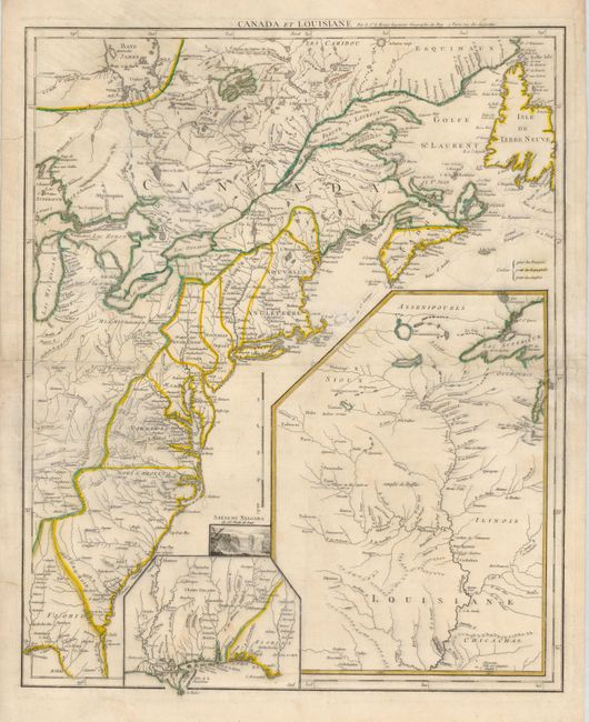
Auction 126, Lot 122
Subject: Colonial United States and Canada
Le Rouge, George Louis
Canada et Louisiane…, 1755
Size: 19.5 x 24.3 inches (49.5 x 61.7 cm)
Estimate: $1,500 - $1,800
Sold for: $1,000
Closed on 12/3/2008
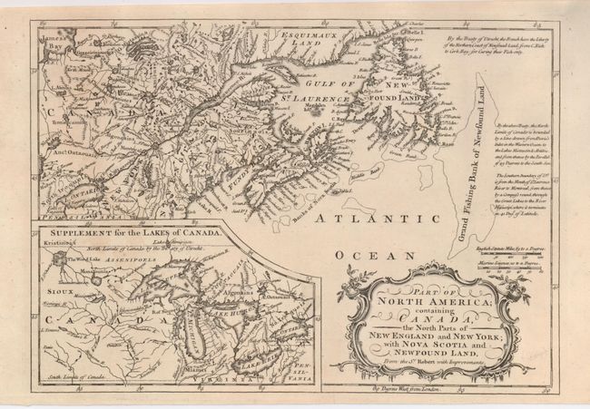
Auction 126, Lot 123
Subject: Colonial United States and Canada
Anon.
Part of North America; containing Canada, the North Parts of New England and New York; with Nova Scotia and Newfoundland. From the Sr. Robert with Improvements, 1760
Size: 11.5 x 8 inches (29.2 x 20.3 cm)
Estimate: $200 - $250
Sold for: $120
Closed on 12/3/2008
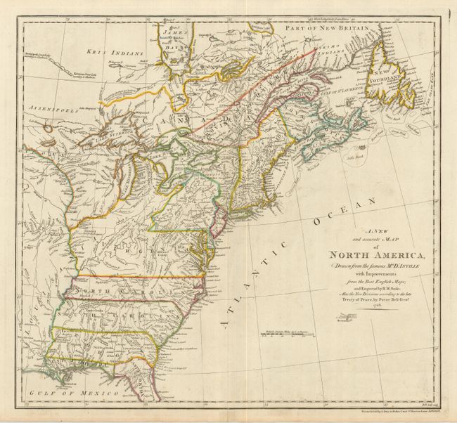
Auction 126, Lot 124
Subject: Colonial United States and Canada
Seale, Richard William
A New and Accurate Map of North America, Drawn from the Famous Mr. D'Anville with Improvements…, 1768
Size: 20 x 18.5 inches (50.8 x 47 cm)
Estimate: $1,800 - $2,200
Sold for: $1,100
Closed on 12/3/2008
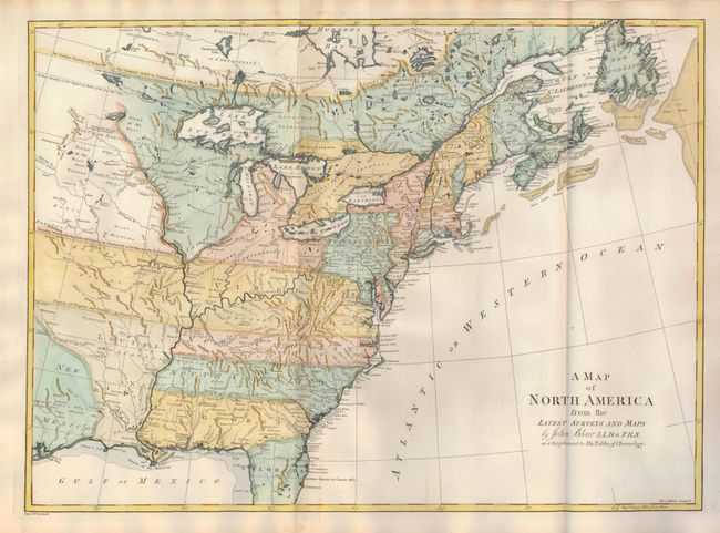
Auction 126, Lot 125
Subject: Colonial United States and Canada
Blair, Rev. John
A Map of North America from the Latest Surveys and Maps, 1768
Size: 22 x 16 inches (55.9 x 40.6 cm)
Estimate: $900 - $1,100
Sold for: $600
Closed on 12/3/2008
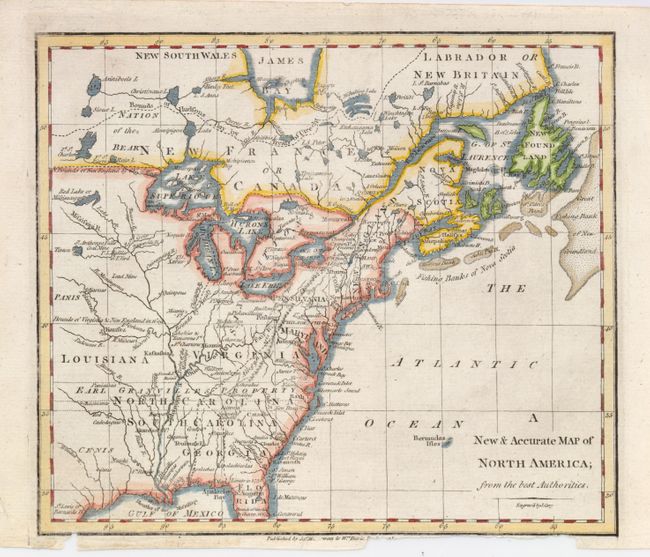
Auction 126, Lot 126
Subject: Colonial United States and Canada
Cary, John
A New & Accurate Map of North America; from the Best Authorities, 1770
Size: 8.8 x 7.6 inches (22.4 x 19.3 cm)
Estimate: $160 - $220
Sold for: $120
Closed on 12/3/2008
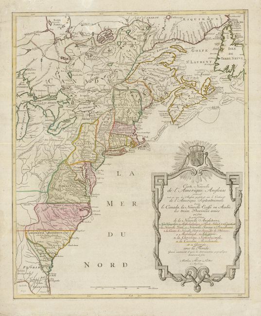
Auction 126, Lot 127
Subject: Colonial United States and Canada
Lotter, Mathias Albrecht
Carte Nouvelle de l'Amerique Angloise contenant tout ce que Anglois possedent sur le Continent de l'Amerique Septentrionale Savoir le Canada, la Nouvelle Ecosse ou Acadie, les treize Provinces Unies…, 1776
Size: 19 x 23 inches (48.3 x 58.4 cm)
Estimate: $1,200 - $1,500
Sold for: $700
Closed on 12/3/2008
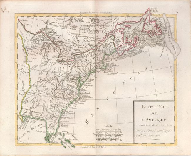
Auction 126, Lot 128
Subject: Canada & United States
Robert de Vaugondy
Etats-Unis de l'Amerique Divises en 13 Provinces avec leurs Limites, suivant le Traite de Paix fait le 20 Janvier 1783, 1785
Size: 9 x 7.3 inches (22.9 x 18.5 cm)
Estimate: $200 - $250
Sold for: $120
Closed on 12/3/2008
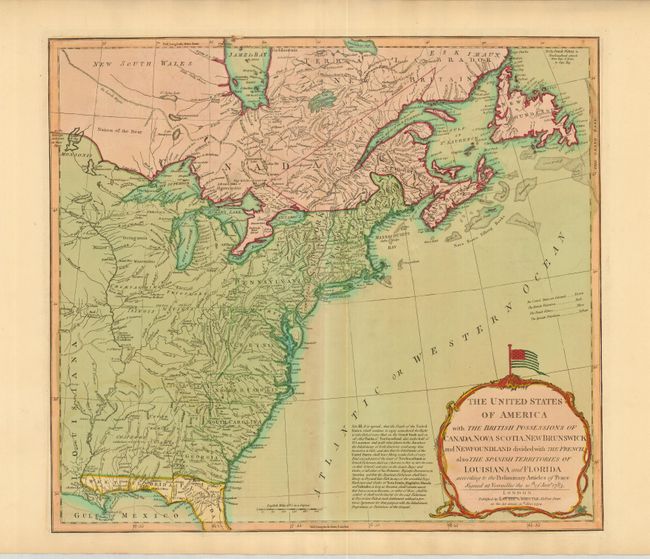
Auction 126, Lot 129
Subject: Eastern United States and Canada
Laurie & Whittle
The United States of America with the British Possessions of Canada, Nova Scotia, New Brunswick and Newfoundland divided with the French, also the Spanish Territories of Louisiana and Florida…, 1794
Size: 20 x 17.8 inches (50.8 x 45.2 cm)
Estimate: $1,600 - $1,800
Sold for: $1,200
Closed on 12/3/2008
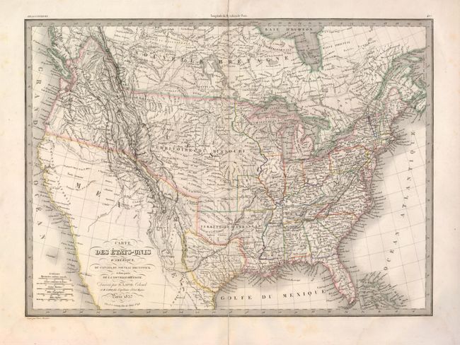
Auction 126, Lot 130
Subject: Canada & United States, Texas
Lapie, Alexander Emile & Pierre
Carte des Etats-Unis d'Amerique, du Canada, du Nouveau Brunswick et d'une partie de la Nouvelle Bretagne, 1837
Size: 21 x 15 inches (53.3 x 38.1 cm)
Estimate: $400 - $500
Sold for: $230
Closed on 12/3/2008

Auction 126, Lot 131
Subject: Northwestern United States and Canada
Wilkes, Charles
Map of the Oregon Territory from the Best Authorities, 1849
Size: 13 x 8 inches (33 x 20.3 cm)
Estimate: $150 - $250
Sold for: $210
Closed on 12/3/2008
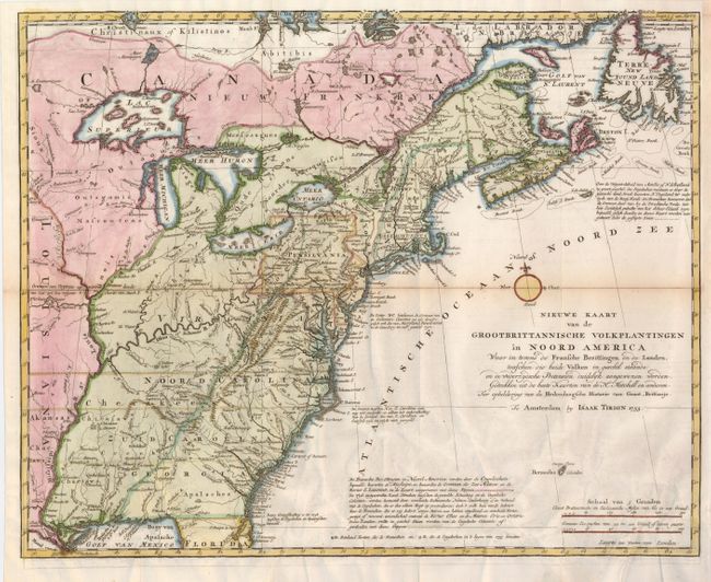
Auction 126, Lot 148
Subject: Colonial United States
Tirion, Isaac
Nieuwe Kaart van de Grootbrittannische Volkplantingen in Noord America…, 1755
Size: 18 x 14.3 inches (45.7 x 36.3 cm)
Estimate: $750 - $850
Sold for: $550
Closed on 12/3/2008
26 lots