Subject: Western North America, Texas
Period: 1840 (published)
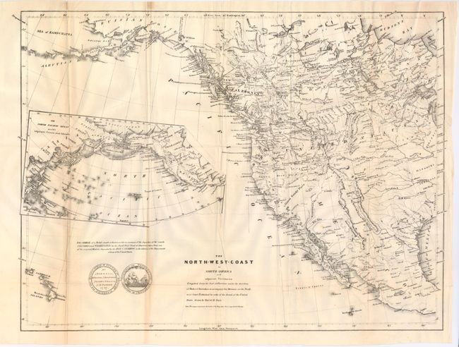
Publication: Greenhow's Memoir of the North West Coast
Color: Black & White
Size:
21.3 x 16 inches
54.1 x 40.6 cm
Greenhow was the translator and librarian to the Department of State, a leading authority on the Northwest and a strong advocate for American growth into that region. This map includes all of the western half of North America extending from Russian Possessions in Alaska, south to Acapulco, Mexico, east to Lake Michigan and west into the Pacific to include the Sandwich Islands. The Independent Republic of Texas shows S. Antonio de Bexar, Austin and names Ft. Alamo, which is rarely called out on maps, including other edtions of this map. Other editions show Washington as the capital of Texas, but the town is not on this issue. Pre-Fremont geography is depicted in the West. The U.S. - Canadian boundary is undefined, reflecting Greenhow’s advocacy of American claims in the area. Locates Ashley's Lake and Lost and Inconstant Rivers. The Buenaventura River flows into the Swamp Lakes & Is., with the Sacramento River flowing from it. Large inset shows the North Pacific Ocean. Today's British Columbia is New Caledonia. A vignette shows the front and back of a medal struck at Boston in 1787 to commemorate the departure of ships Columbia and Washington for an early exploration by the U.S. to the Pacific Northwest. Drawn by David H. Burr, this map was also published as Sen. Doc. 174, 26th. Cong, 1st Sess.
References: Phililps (M) p. 603; Wheat [TMW] #447.
Condition: B+
Folding as issued. One fold with split closed on verso with archival tape and some soft folds. A long tear enters map at binding trim, closed on verso with old repair.