Back-to-school time is hard to miss - it is evidenced by sales on everything from clothes to school supplies, neighborhood pools closing for the end of summer, college campuses filling up again, and pictures of kids' first day of school plastered all over Facebook (mine included). Back-to-school time always reminds me of the joy of learning and the incredible creativity and ingenuity that kids display. In honor of this time of year, I asked elementary-school aged children to harness their inner cartographer and create some maps. I instructed them to create a map of any place, real or imagined, and they were allowed to use pencils, markers, crayons, and colored pencils. I worked with a second grade class (ages 7-9), who were given only 30 minutes to complete their map, as well as a fifth grade class (ages 11-12), who were allowed to work as individuals or pairs, and worked on their maps over a one-week period. The fifth graders also wrote a paragraph explaining their map. I was both surprised and delighted by the incredible imagination, artistry, and map knowledge that these kids displayed. Please enjoy these little masterpieces!
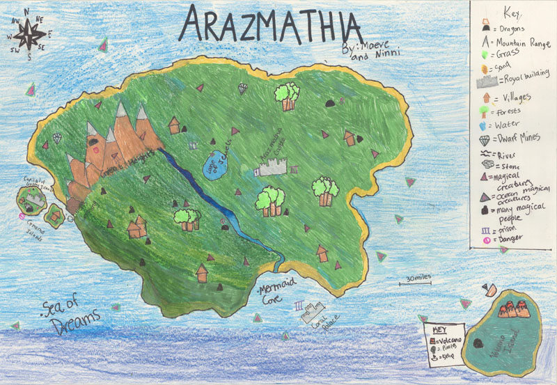
Arazmathia, by Maeve & Ninni (age 11)
The island of Arazmathia is a magical place in the middle of the Sea of Dreams. Near the center of the island are the Lake of Jewels and Arazmathia Castle, where the Queen resides. The Great Heights mountain range dominates the western end of the island, while Mermaid Cove lies along the southern coast. Mermaid Cove is an underwater mermaid community ruled by King Poseidon. According to Maeve and Ninni, the island "has many more magical sites that can be wonderful but dangerous." Arazmathia is surrounded by several smaller islands, including Gnome Island and Volcano Island. The keys to the symbols on this map are both colorful and useful, noting the locations of dragons, dwarf mines, pirates, and prisons. Maeve and Ninni highly recommend visiting the island: "Even though Arazmathia is incredibly hard to find, once you do, it will feel like you're living in a paradise."
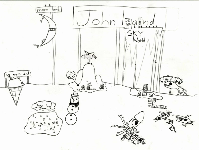
John Land, by John (age 9)
John Land is a curious and fascinating place. There's plenty of fun to be had, such as having snowball fights in Snow Land, eating Ice Cream Land (which is edible, of course), and visiting the large unicorn head statue. However one must be careful of the dangers, such as the giant carnivorous fish and squid, falling off of Moon Land, or the ominous yet alluring Shark Land. John Land gives us a particularly good glimpse of what goes on in the mind of a 9-year-old boy!
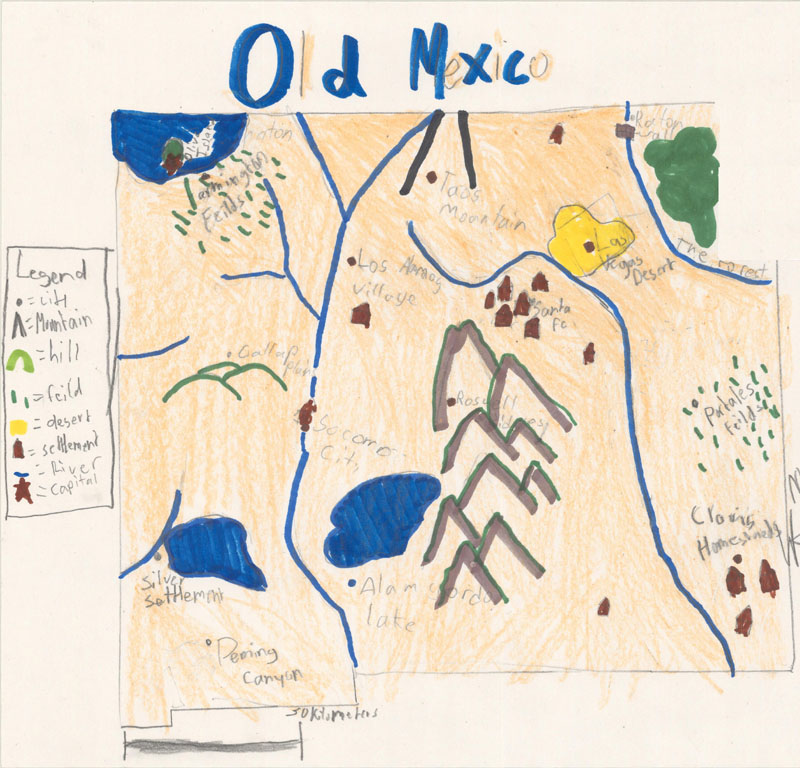
Old Mexico, by Jaewon & Luke (age 11)
This map shows the state of New Mexico before it was "new." Prior to the creation of New Mexico, the area was known as Old Mexico and was inhabited by Pueblo Indians. The capital was on Olive Island in a lake in the northwest corner of the state. Old Mexico was filled with rivers, lakes, hills, fields, and cities, including Santa Fe, Los Alamos Village, Socorro City, and Clovis Homestead. The Las Vegas Desert was across the river from Santa Fe, and a large mountain range filled the center of the state. Jaewon and Luke shared some of the history of Old Mexico: "Old Mexico was driven out by western expansion settlers, and then it became New Mexico. This is why Old Mexico is no longer around... There is no more living evidence of Old Mexico except for this map as it was destroyed by the settlers."
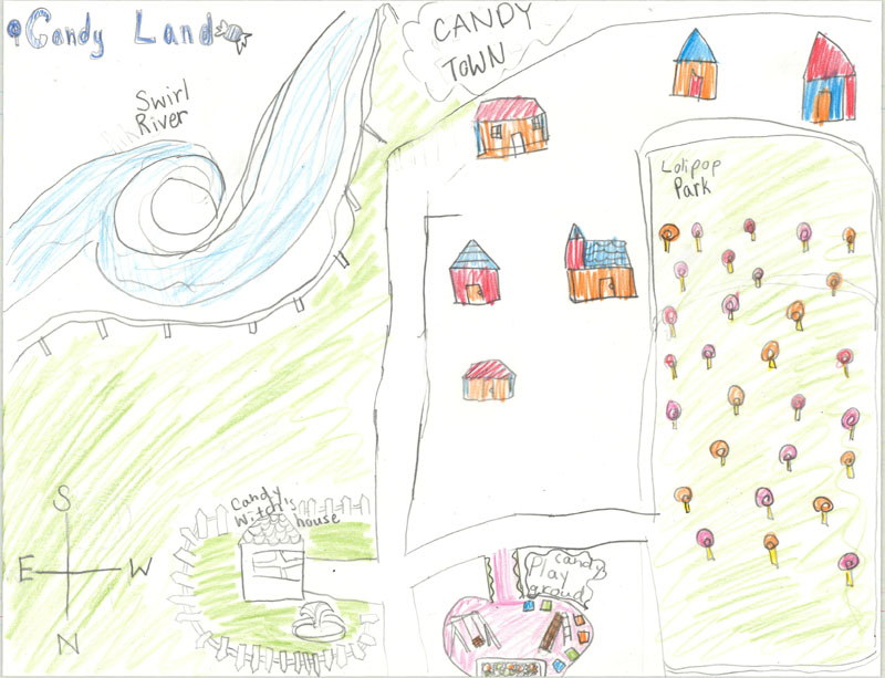
Candy Land, by Yuki (age 8)
Of course every kid's dream is for the Hasbro board game "Candy Land" to come to life, and Yuki helps us envision what it would be like. Adjacent to the Swirl River is Candy Town, which is filled with lovely homes. Around the town are several community spaces, such as Lolipop Park and Candy Playground. Beware of the Candy Witch's House at the northern end of the city (as the compass rose orients north to the bottom of the map). Although the Candy Witch's house is mostly fenced in, it is located adjacent to the playground and could prove tempting to unsuspecting children.
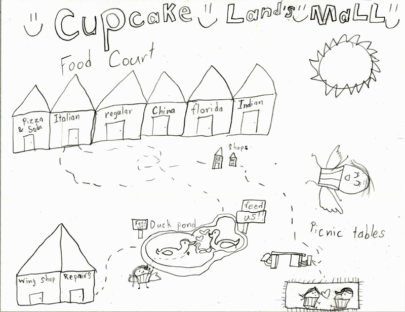
Cupcake Land's Mall, by Aashna (age 8)
Possibly located near Candy Land, Cupcake Land has a wonderful shopping mall. This mall map shows the main shops and features that can be found, such as the Duck Pond (with signs that encourage you to feed the ducks), picnic tables, and a Wing Shop, where Cupcake People can get wings to help them fly. There is a large food court at the mall with an excellent selection of different types of cuisine: Pizza & Soda, Italian, Regular, China, Florida, and Indian. If you're in the mood for Regular or Florida food, Cupcake Land's Mall is the place to go!
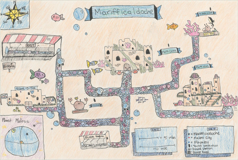
Marifficaldoche, by Anna & Madison (age 11)
The underwater city of Marifficaldoche on Planet Maless is a feast for the eyes and a special retreat for sea creatures! Some of the key attractions are Marff Castle, the School-O-Fish, the Bubble Station, and Marff Way, which is a series of condos that serve as residences for the sea creatures. The Bubble Road serves as the primary system of transportation between various locations. There are several important statues in Marifficaldoche, including King Krabz, who was the first king who lived in Marff Castle, and Sir Krabz-a-Lot, who lived from 2091-3000 and is best known for defeating the Head of the Sharks. The map is handsomely adorned with a compass rose, distance scale, key, and an inset map showing the location of Marifficaldoche on the Planet Maless. Anna and Madison would like you to know that Marifficaldoche is for all types of sea creatures, except for sharks.
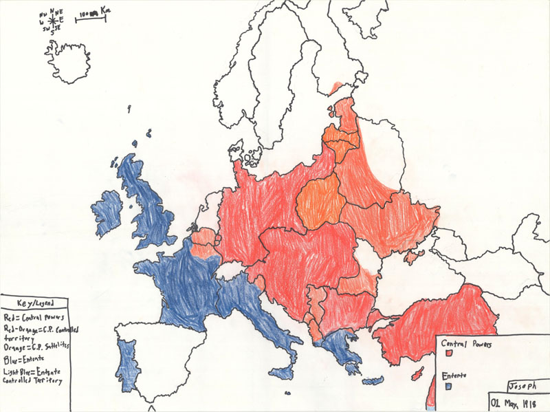
World War I - 1918, Europe, by Joseph (age 12)
This is likely the most recognizable map in the group, and was drawn free-hand (yes, really!) by a history-loving, map enthusiast. Joseph's map shows the areas controlled by the Entente and Central Powers on May 1, 1918, which was almost exactly 100 years ago to the day when this map was drawn. The color-coded legend identifies the Central Powers in red, the territories controlled by the Central Powers in red-orange, and the Entente in blue. According to Joseph, "the map represents how World War I developed and progressed over time until it finally ended and the sacrifice that so many millions gave their lives for."
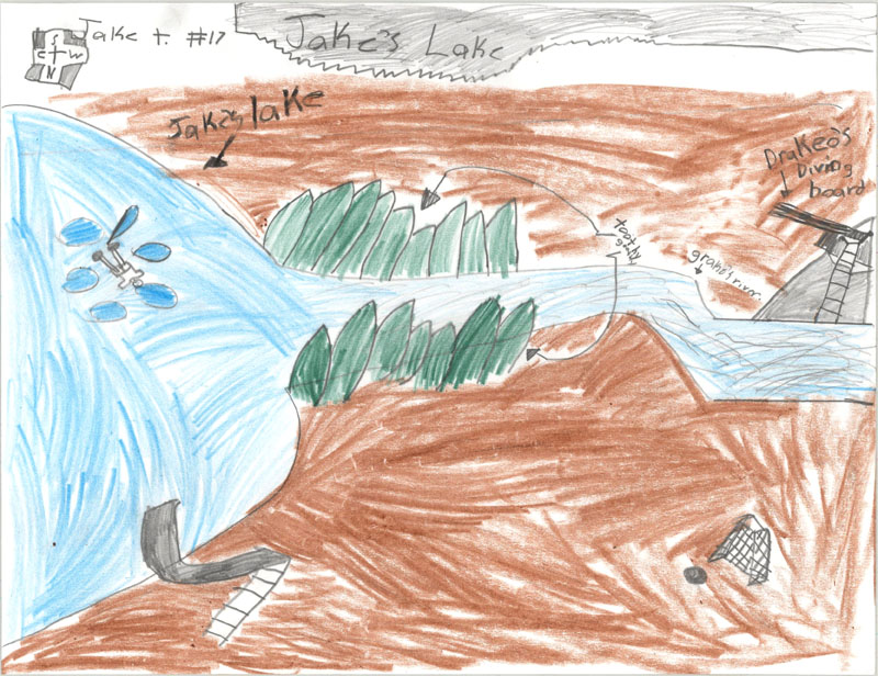
Jake's Lake, by Jake (age 8)
This bird's-eye view of Jake's Lake is a great reminder of summer. Grake's River flows through the Toothy Goothy mountains into Jake's Lake. The lake includes a waterslide, while Drakeo's Diving Board is along the river. A soccer goal and soccer ball are on the riverbank for those who have had enough water play. Jake clearly enjoys the lake, and can be seen swimming alongside some floats in the lake.
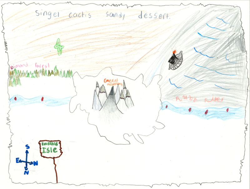
Emerald Isle, by Mia (age 8)
Centered on the majestic Emerald Mountains, this map shows a portion of Emerald Isle, with north oriented to the bottom of the map. The Ruby River flows adjacent to the mountain range, and one large ship can be seen floating upriver. Also of note are the "Dimond" Forest and the "Singel Cactis Sandy Dessert" (also known as the Single Cactus Sandy Desert).
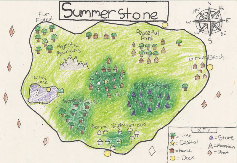
Summerstone, by David & Jack (age 11)
Another scenic island, Summerstone is filled with forests, mountains, cities, and great shopping. There are many lovely places to reside, including Peaceful Park, Normal Neighborhood, Brave Beach, and Springwood, the Capital. The Silly Stores are a favorite tourist spot, as is Little Lake on the western end of the island. Sailing is a popular activity among residents on Summerstone, and there are several docks along the coast that serve this purpose, including one on Little Lake. A number of boats can be seen in the waters surrounding the island, denoted by diamonds.
I hope you've enjoyed these fun and creative maps from the next generation of cartographers! A big thank you to Mrs Bernheart and Mrs. Miller for allowing me to work with their students on these map projects. Please head to our Facebook page (https://www.facebook.com/OldWorldAuctions/) and post any comments you have about these maps. We will also be posting more kid maps on our Facebook page soon!
OWA Now One of the Largest Repositories of Digital Maps in the Worldby Jon & Eliane Dotson
A few weeks ago we launched one of the most ambitious projects on our website to date: we added over 80,000 high-resolution, digital images to our auction archive. This makes Old World Auctions one of the largest repositories of digital map images in the world, with more than either the Library of Congress or the British Library! Now, nearly every item we've auctioned since 1999 (when Old World Auctions transitioned from a mail-order auction to an online auction) is available with a full catalog description and high-resolution digital images. This new feature is indispensable for collectors, researchers, and map enthusiasts alike. Here is a quick link to our auction archive: https://www.oldworldauctions.com/catalog/archive
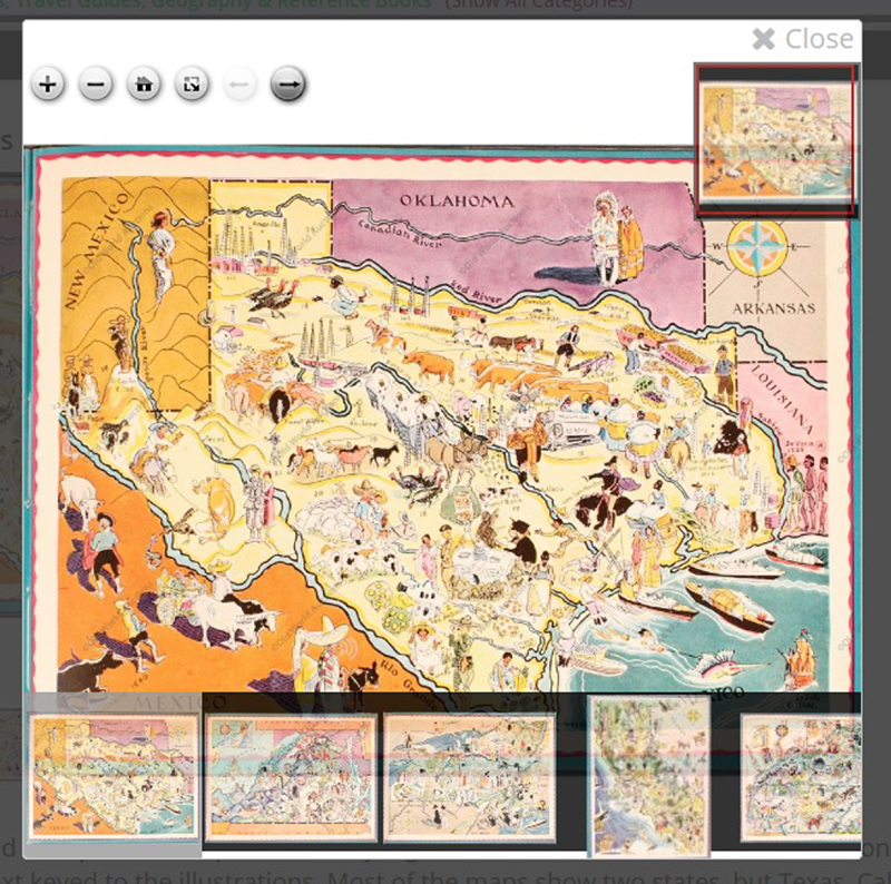
To view a digital image, simply click on the small image on any lot page and the high-resolution image will pop up and look like this:
At top right is a small box that shows the full image, with a red rectangle that identifies which part of the map or book you are currently viewing. If there are multiple images associated with that lot, they will show up along the bottom of the screen, and you can click on any one to view it. To close the high-resolution image, simply click the "X Close" button at top right. The row of buttons at top left help you zoom into the image. Here is a close-up of the buttons:
From left to right, here is what each button does:
The "+" zooms in closer on the image. This button can usually only be clicked 2-3 times before you are fully zoomed in.
The "-" zooms the image further out.
The house button brings the full image back into view when you are zoomed in.
The square and arrow button increases the size of the viewing area to your full screen. To exit the full screen mode, click the escape key (Esc) on your keyboard.
The right and left arrows can only be used if there are multiple images in that lot, and these buttons will move you to the previous or next image in the lot.
These controls are the same whether you are viewing an image in the archive or the current auction. We hope you will play around with the digital images and get up close and personal with our maps!
(Note: There are some items in our archive for which we do not have high-resolution images - primarily for some of the items between 1999 - 2003. If there is no high-resolution image, you can still open the image and view it full screen, but you cannot zoom in on the image.)