The history of Lake Parime cannot be fully explained without first discussing El Dorado, known as the Golden City. The term El Dorado was first used by Europeans to describe the chief of the Chibcha (or Muisca) tribe in Colombia, who was said to practice a ritual involving gold. In an initiation ceremony for the new chief, the chief was covered in gold dust prior to being cleansed in the sacred Lake Guatavita, while additional offerings of gold, emeralds, and other gems were tossed into the water. This ceremony is described in the accounts of several European explorers, including Gonzalo Fernandez de Oviedo (1541), Juan de Castellanos (c. 1588), and Juan Rodriguez Freyle (1638). Thus "El Dorado" initially was used to signify "the golden man."
The accounts of the ceremony and "the golden man" eventually transformed into the myth of a golden city, named El Dorado, which lay on the banks of a large lake. Spanish Conquistadores were aware of the gold, silver and precious stones of South America in the early 16th century, and sought to exploit these riches well before the legend of El Dorado took shape. The presence of gold and silver among the Inca and other native tribes of South America fueled both the myth of El Dorado and the desire of Europeans to find these riches. This mythical city captured the imagination and fascination of Spanish, Portuguese, Dutch, English, and German explorers for two centuries, resulting in many ill-fated attempts to find El Dorado.
The earliest explorers focused their efforts in the Andes mountains, particularly in Peru and Colombia, the locations of the Inca and Chibcha tribes. When these expeditions failed to find the fabled city, explorers began to venture farther east. After being appointed governor of Quito in 1541, Spaniard Gonzalo Pizarro, brother of Francisco Pizarro, conquerer of the Incan Empire, set forth eastward with Francisco de Orellana to find El Dorado. The expedition proved fatal to the majority of the 4,000 men accompanying the journey, primarily due to starvation, disease, and attacks from natives. Pizarro abandoned the expedition but ordered Orellana to continue downstream. Although the search for El Dorado was a failure, Orellana eventually reached the Atlantic Ocean and was credited with discovering the Amazon River.
In 1584, Spaniard Antonio de Berrio was determined to find El Dorado from the Orinoco River. He was encouraged by the account of Juan Martinez, believed to be Juan Martin de Albujar, who had taken part in Pedro de Silva's expedition of the area in 1570, only to fall into the hands of the Caribs of the Lower Orinoco. Martinez claimed that he was taken to the golden city in blindfold, was entertained by the natives, and then left the city and couldn't remember how to return. Berrio made several attempts to find the golden city, but was hindered by the terrain and by hostile Indians.
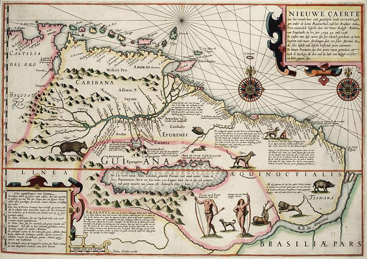
Jodocus Hondius Sr., Nieuwe Caerte van het Wonderbaer ende Goudrycke Landt Guiana, 1596.
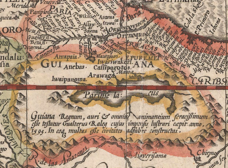
Jodocus Hondius Sr., Americae Meridionalis, 1606.
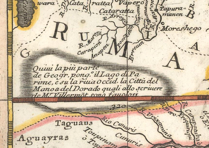
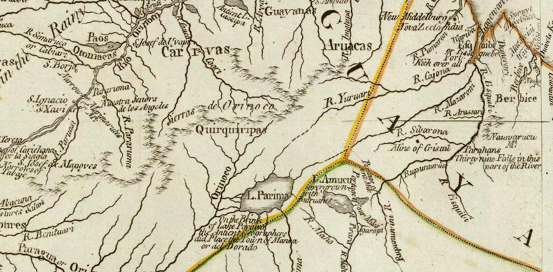
The myth of El Dorado came to the attention of Sir Walter Raleigh, who led an expedition to Guiana in 1595, first capturing Berrio in Trinidad to learn more about the golden city and its whereabouts. Like many explorers before him, Raleigh's attempt to find the city was unsuccessful. Raleigh ordered another expedition in 1596, led by Lawrence Keymis, who reported that the golden city stood on the shores of a lake known as Parime. Raleigh then published The Discoverie of the Large Rich, and Bewtiful Empyre of Guiana with a Relation of the Great and Golden Citie of Manoa (which the Spaniards Call El Dorado) in which his discoveries and knowledge of the fabled city were greatly exaggerated. The book was well received and served to popularize the fabled city of Manoa on the edge of Lake Parime.
As a result of Raleigh's work, maps began to appear depicting El Dorado and Lake Parime. One of the first was the elder Jodocus Hondius' Nieuwe Caerte van het Wonderbaer ende Goudrycke Landt Guiana, which was published in 1596 and was based on Raleigh's work. Hondius' map depicts an elongated Lake Parime south of the Orinoco River, with the majority of the lake positioned south of the equator, and with Manoa on the northern shore, towards the eastern half of the lake. Manoa is noted as "the greatest city in the entire world." Hondius' map was subsequently copied by Theodore de Bry and published in his popular Grands Voyages in 1599. When Hondius published a completely revised edition of Mercator's Atlas in 1606, it included a map of South America featuring Lake Parime with the majority of the lake located south of the equator, and with Manoa again along the northern shore, although perhaps not quite so far east.
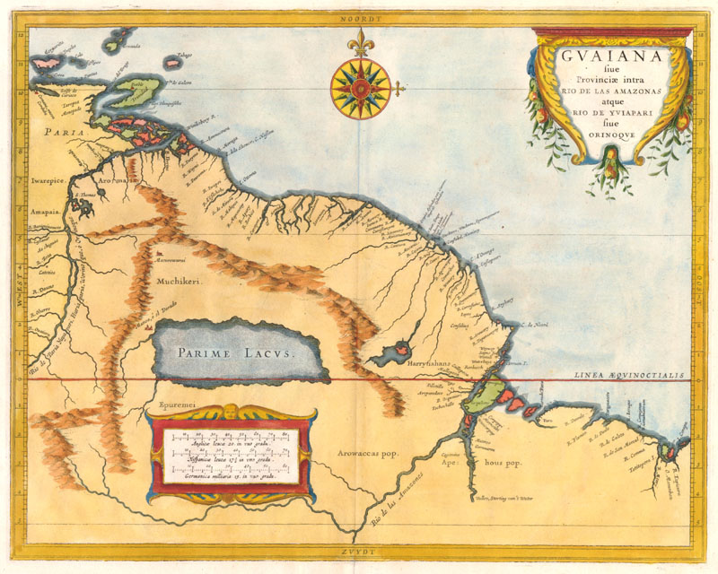
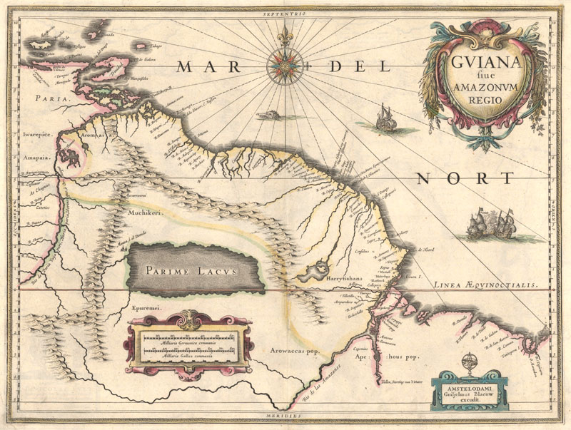
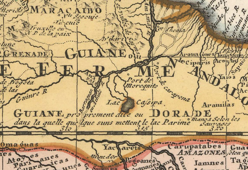
The story of the golden city on the shore Lake Parime continued to spread, and began to appear on most maps of South America and Guyana throughout the 17th century. In contrast to previous representations of Lake Parime, Hessel Gerritsz created a map of Guyana with an enormous and almost rectangular Parime Lacus just north of the equator, and "Manoa, o el Dorado" now on the northwestern shore. Gerritsz' map was first published in 1625 in Johannes de Laet's Nieuwe Wereldt ofte Beschrijvinghe van West-Indien. (The author has not yet determined what caused Gerritsz to alter the shape of Lake Parime or to move the Golden City to its northwestern shore.) In the 1629 edition of Jodocus Hondius Jr.'s Atlantis Maioris Appendix, a new map of Guiana was added that was a close copy of Gerritsz' map. Upon Jodocus Hondius Jr's death in 1629, Willem Blaeu purchased about 40 of his copperplates, including the map of Guiana, and republished it with his own name substituting that of Hondius, first in his 1630 Atlantis Appendix and then in numerous Blaeu atlases through 1670.
Hessel Gerritsz, Guiana sive Provinciae intra Rio de las Amazonas atque Rio de Yuiapari sive Orinoque, 1625.
Willem Blaeu, Guiana sive Amazonum Regio, 1630.
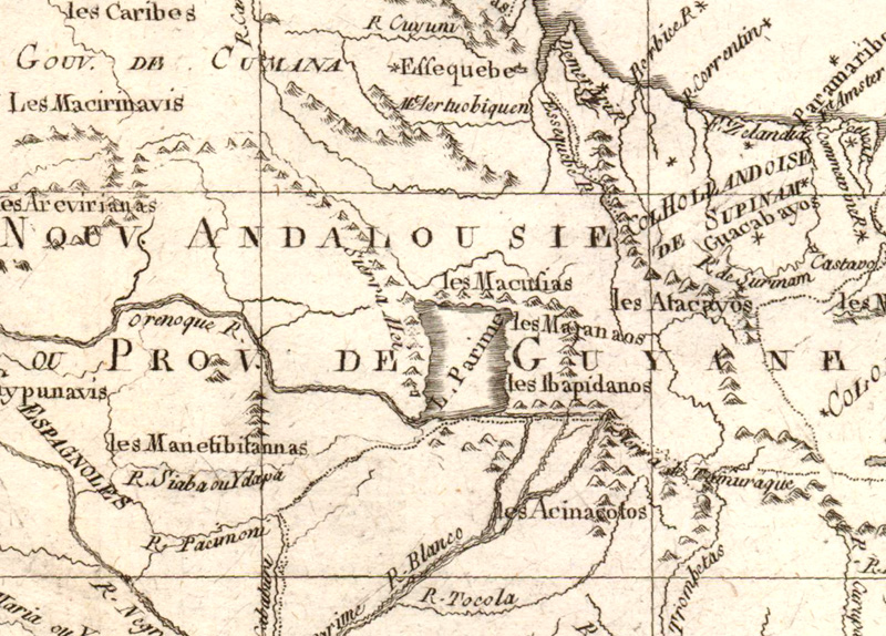
By the turn of the 18th century, Lake Parime and El Dorado begin disappearing from maps, with cartographers calling its existence into question. On Vicenzo Maria Coronelli's two-sheet map of South America, first published in 1691, a conjectural Lake Parime is depicted with a note explaining that although the majority of geographers place the lake with Manoa on its western shore, the account is "fantastical." Guillaume Delisle does not depict Lake Parime on his map of South America dated 1700, but he does note the possibility of its existence and locates "Manoa selon les sauvages" (Manoa according to the savages). In 1705, Pierre Moullart-Sanson published a map of South America with an unnamed lake in the area of Lake Parime, but without any mention of Manoa.
Vicenzo Maria Coronelli, America Meridionale, 1691.
Guillaume de L'Isle, L'Amerique Meridionale Dressee sur les Observations de Mrs. De l'Academie Royale des Sciences, 1700.
Pierre Moullart-Sanson, Amerique Meridionale Divisee Suivant les Regions les Souverainetes les Religions et les Langues, 1705.
Rigobert Bonne, Carte du Nouv. Rme. de Grenade, 1780.
Robery Sayer, A Map of South America Containing Tierra-Firma, Guayana, New Granada, Amazonia, Brasil, Peru, Paraguay, Chaco, Tucuman, Chili and Patagonia. From Mr. d'Anville with Several Improvements and Additions, and the Newest Discoveries, 1787.
Despite the lack of scientific evidence for Lake Parime and El Dorado, they still appeared on a few maps even towards the end of the 18th century. Rigobert Bonne's map Carte du Nouv. Rme. de Grenade, circa 1780, shows a rectangular-shaped Lake Parime oriented north-south and located further to the east, with no city on its shores. And Robert Sayer's map of South America dated 1787 shows Lake Parime and includes a note on Manoa. The legend wasn't disproved until Alexander von Humboldt's expedition through Latin America from 1799-1804. Humboldt's extensive survey of the Guyana river basins and lakes led him to conclude that Lake Parime did not exist, and that it was likely inspired by the seasonal flooding at the confluence of rivers. And after two centuries of unsuccessful expeditions for El Dorado, the myth of the golden city disappeared as well.
Although there is a kernel of truth in the fabled Lake Parime and El Dorado, their history is one of great metamorphosis. Over time a gold-clad Chieftain turned into a Golden City, and Lake Guatavita, located near Bogota in the Colombian Andes, transformed into the mythical Lake Parime, located hundreds of miles to the east in Guyana. Despite the fact that Lake Parime and the city of El Dorado were determined to be myths, the name El Dorado began to be used to identify places where one could hope to find wealth and has even served as a metaphor to represent one's ultimate goal.
Bibliography:
Baynton-Williams, Ashley, Lake Parime, MapForum Issue 2, London, Summer 2004.
Goodman, Edward Julius, The Explorers of South America, University of Oklahoma Press, Norman, 1992.
Humboldt, Alexander von, Personal Narrative of Travels to the Equinoctial Regions of America During the Years 1799-1804, Henry G. Bohn, London, 1853.
Shirley, Rodney, Maps in the Atlases of the British Library, The British Library, London, 2004.
Symbolism and Allegory for Map Collectorsby Marti Griggs
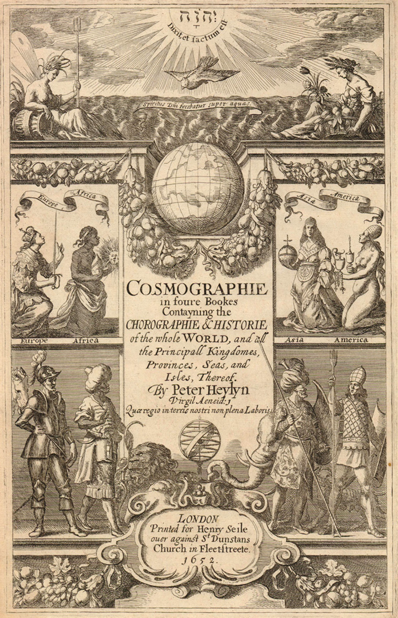
During the Renaissance artists used iconography to convey specific themes and combined symbols to weave elaborate allegories. Their audiences were familiar with Greek and Roman mythology and were deeply knowledgeable of Christianity from which these symbols originated. The art of mapmaking was as much a part of the whole Renaissance movement as were painting and literature. Mapmakers also used a vast repertoire of symbols that were universally understood by their customers, but are potentially mystifying to modern collectors of old maps.
Allegorical figures personify abstract concepts, such as glory, wisdom, prosperity, and commerce. They can also represent one of the liberal arts, such as geography, astronomy or history; a nation, continent or heavenly body; one of the virtues or vices; the cardinal directions; the four elements or four seasons.
A rudimentary knowledge of the iconography commonly used in cartographic art is helpful in understanding the cultural context of early maps. Many symbols are obvious, while others are more difficult to decipher and understand. It is not necessary to understand all the complexities in order to enjoy and appreciate the various embellishments that can be found on maps and especially on the title pages of geographical works. But it is helpful to know some of the main characters and symbols.
The title page from Peter Heylin’s Cosmographie (1652) illustrates a variety of symbols characteristic of cartographic art. The Divinity (rays of the sun, Hebrew Jehovah, and dove) and his creation, clouds (Air), sea nymph (Water) and Ceres (Earth), form the top panel. The second panel shows both European and Christian dominance in the female personifications of the continents. The final panel presents the male representatives of the continents, each in military dress with their attendant animals. The garland of fruit symbolizes wealth and plenty.
Several recurrent symbols are seen in Frederick de Wit’s title page for the Atlas Major (1690). Seated in a throne is the earth goddess Cybele with her turreted headpiece and lion at her feet. She is instructing the personification of History and Geography while the angel of Fame blows her trumpets emphasizing the importance of the atlas. Perched atop a globe is a very unusual representation of the four continents pictured as infants. In the background, Atlas holds up the heavens while Neptune and his entourage skim across the sea.
One of the most commonly used themes in cartography is Europe receiving homage from the people of the world signifying European dominance throughout the world. Generally Europe is depicted as the regal queen Europa with the personifications of the continents or a specific region depicted in a subservient manner. The continents are generally portrayed as female figures, but occasionally male soldiers served the same purpose.
Biblical scenes are a prevalent theme on maps, particularly those of the world and the Holy Land. The Divinity may be shown in a variety of ways including the rays of sunshine, an all-seeing eye, the Greek letter delta or the Hebrew letters JHVH (Jehovah). Commonly used icons include the cross that symbolizes the Christian religion, the crescent of the Islamic religion and an arrow that represents pagan religions or heathenism. A prevalent theme pictures Christianity defeating paganism or Islam, or good triumphing over evil.
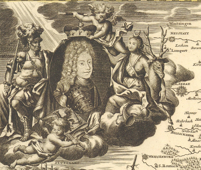
The portrait of a king, queen, or emperor signifies royal affiliation, that the monarch has commissioned the work, or that the region mapped is under his or her possession. Representations of royalty are often accompanied by the personification of Fame, or Honor, carrying (or wearing) a laurel wreath and blowing a trumpet. She sometimes carries two trumpets of different lengths symbolizing good and ill fame.
The dedication cartouche from J.B. Homann's map of the Duchy of Wurtemberg (1710) features the portrait of the Duke, Eberhardo Ludivico, surrounded by allegorical figures. Mars represents military strength while Diana signifies the bountiful wildlife of the duchy. Notice the rays of sunshine falling on the portrait symbolizing God's blessings.
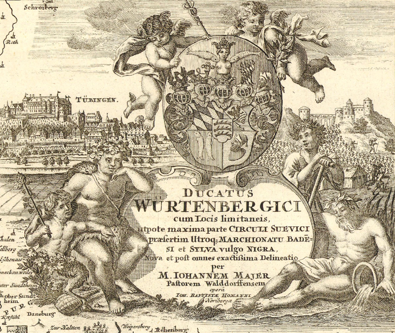
The title cartouche of J.B. Homann's map of the Duchy of Wurtemberg (1710) symbolizes peace (putti with olive branch), plenty (Bacchus and the satyr), community (figure with a spade), and commerce (putti in the guise of Mercury and the river god).
Peace and prosperity are also recurrent subjects in cartographic art. The concepts were depicted through a number of symbols including the earth goddesses with overflowing cornucopia, the combination of cornucopia or garland of fruit, rudder and globe symbols, and by figures representing peace, justice, and abundance. Peace is generally pictured as an angel holding a healing caduceus, olive branch or palm and is associated with doves. Justice is the familiar blindfolded figure holding a sword in one hand and scales in the other.
A group of figures engaged in various scientific pursuits is a ubiquitous subject signifying the importance of expanding knowledge. In these scenes, a host of putti is usually joined by the female personifications of History, Geography and Astronomy and sometimes the recognizable figure of a prominent geographer like Ptolemy or Mercator. These figures, especially putti, representing surveying, navigation and mapmaking, frequently embellish cartouches.
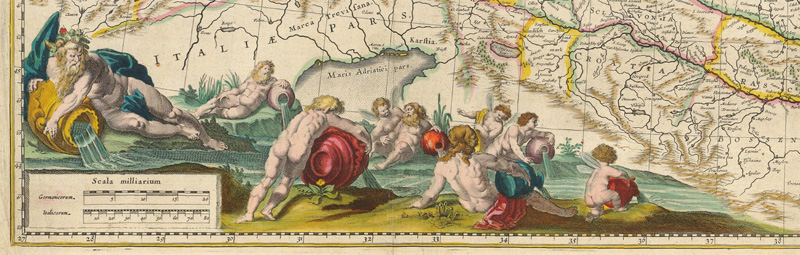
Images of trade and commerce dominated pictorial cartouches in the 18th century. Mercury, mythological god of trade and commerce and the symbol of exploration, is a recurrent figure found in cartography from this period. Neptune and river gods are other symbols associated with naval power and commerce.
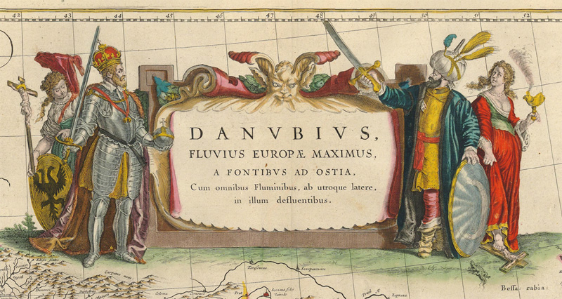
The title cartouche for Willem Blaeu's map of the Danube (circa 1635) features the conflict between Christianity and Islam. At left Europa (holding a crucifix) and the Holy Roman Emperor (double-headed eagle on shield) face-off with an Ottoman Sultan and Asia (holding a censer), who stands on a crucifix. At bottom the river Danube is personified by a host of river gods and playful nymphs signifying the importance of trade and commerce along the river.
As ornamentation became less elaborate, concepts were increasing alluded to simply with the use of the imperial and nationalist symbols, such as the American eagle or Russian bear. American mapmakers used symbols, such as a railroad, emphasizing the concepts of Manifest Destiny and the Age of Progress.
Those with an interest in symbolism and allegory can learn more from Rodney Shirley’s Courtiers and Cannibals, Angels and Amazons, which explores the art of cartographic title pages. This article is excerpted from the second edition of Collecting Old Maps, due for publication in February, 2015. The book includes an extensive list of the themes, concepts, mythical figures, and symbols frequently seen on old maps.