Collector's Corner: The Art and Science of the Compass Rose by Eliane Dotson
Often the central focal point of a map, the compass rose has played an important role through the centuries with regards to both cartography and navigation. However, one must first know a little of the history of the compass before one can understand the origin of the compass rose.
History of the Compass Although the exact origin is unknown, there were several discoveries that led to the creation of the compass. The basic compass requires a magnet that reacts to the earth's magnetized field, and will physically align itself with the magnetic poles (in a north/south orientation). The only naturally occurring mineral on earth to exhibit strong magnetic properties is magnetite, and a magnetized piece of magnetite is called a lodestone. The magnetic properties of the lodestone were known to the ancients, as evidenced by the writings of Plato and Euripides, and were also known independently by the Chinese, possibly as early as 1100 BC. The first primitive compasses using lodestones were believed to have been created by the Chinese around 140 AD to be used for the purposes of spiritual life. Various rudimentary forms of compasses were used over the next millennium, both for spiritual aligning and for basic orientation and navigation. Knowledge of the compass is believed to have made its way to the Mediterranean around the 12th century, with Italy presumed to be the entry point. The first written description of a freely pivoting compass needle (in contrast to earlier known floating apparatus) came from Petrus Peregrinus de Maricourt, a French scholar, in 1269. The "modern" mariner's compass was then invented (or more accurately, improved) circa 1300 in southern Italy, most likely at the port of Amalfi. This modern compass incorporated a drawing of a compass rose affixed to the base of a box holding a pivoting magnetic needle, thereby simplifying the use of the compass as a navigational tool.
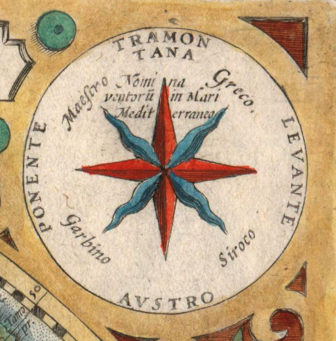
Origin of the Compass Rose Prior to the advent of the compass rose, direction was measured differently in various parts of the world. The Chinese measured direction based on the 12 signs of the zodiac; the Arabs used the stars and constellations; and Europeans relied on the winds blowing in the Mediterranean. Consequently, the precursors to the compass rose were the stella maris (star of the sea) and the wind rose. The wind rose denoted the directions of the winds, with 8 principal winds, 8 half-winds, and 16 quarter-winds. Initially, no distinction was made between a directional point and the wind that emanated from that direction. In much of Europe during the Middle Ages, the names of the 8 major winds were based on the Mediterranean lingua franca, spoken between sailors from various countries surrounding the Mediterranean Sea: Tramontana (north), Greco (northeast), Levante (east), Sirocco (southeast), Ostro (south), Libeccio (southwest), Ponente (west), and Maestro (northwest). The names of the half-winds and quarter-winds were created by combining the names of the major winds. All Medieval mariners were expected to be able to name all 32 winds, which was known as "boxing the compass."
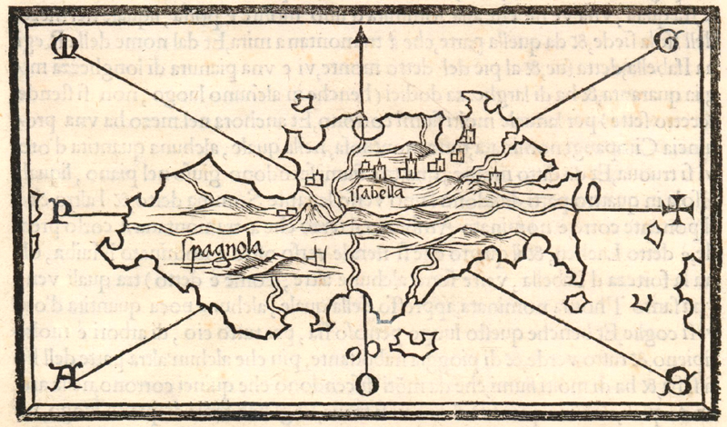
The first compass roses, or wind roses, began to appear on Portolan charts in the late 1300s. Compass roses, along with their radiating and intersecting rhumb lines, were the foundational elements used on Portolan charts. Rhumb lines followed a single direction on a compass, and compass roses were depicted at the intersection of rhumb lines, often with multiple roses on a single chart. The rhumb lines created a grid to assist the cartographer in measuring distance and in more accurately plotting various points on the chart. As a result, compass roses and rhumb lines not only helped sailors navigate their way, but also enabled cartographers to reproduce and refine their maps. As magnetic compasses came to more prominent use, wind roses became known as compass roses, and for mariners along the Mediterranean, the names of the directions initially retained their original wind names.
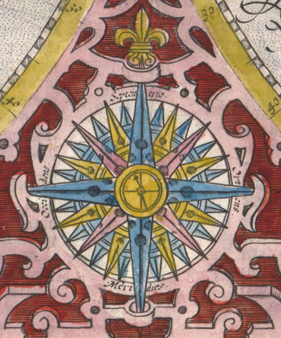
Later, the names of the cardinal directions changed. Many 16th and 17th century mapmakers used Latin names - Septentrio, Oriens, Meridies, Occidens - which are commonly seen on maps. In the 16th century some cartographers began to use the cardinal terms that are used today by most western European languages - North, East, South and West. These terms are based on Carolingian names believed to have been created by the Frankish King Charlemagne (circa 800 AD), who renamed the principal winds in his own language. North was based on Nord (likely meaning "wet" or from the rainy lands), East was based on Ost (meaning shining place, sunrise), South was based on Sund (sunny lands) and West was based on Vuest (meaning dwelling place, or where one goes in the evening).
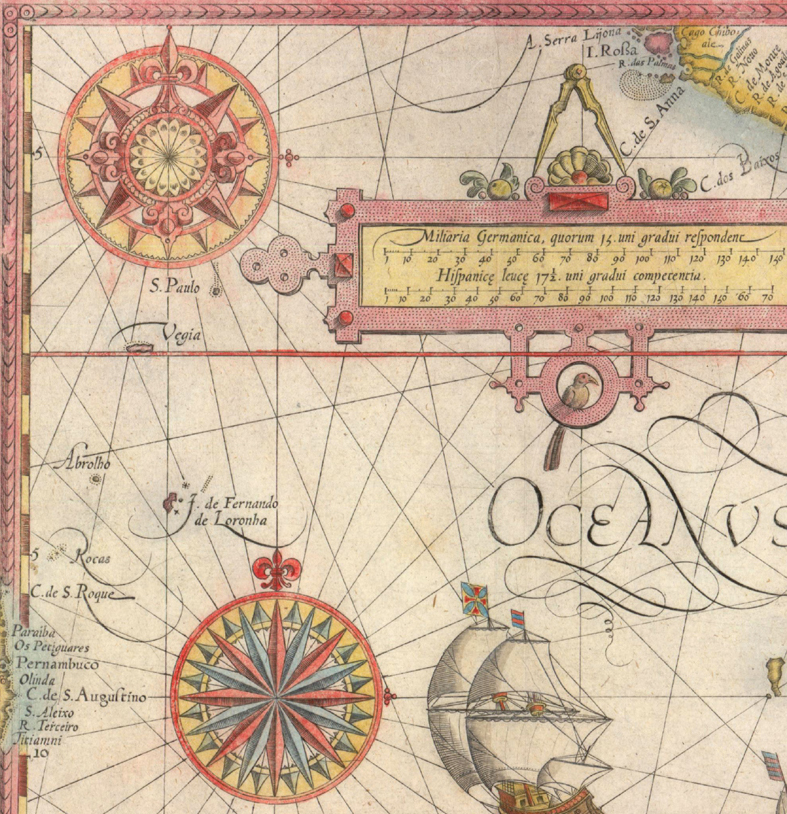
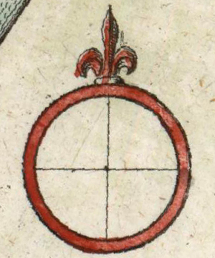
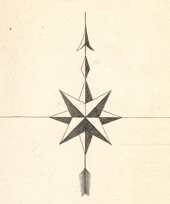
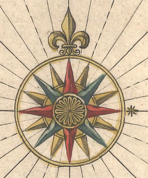
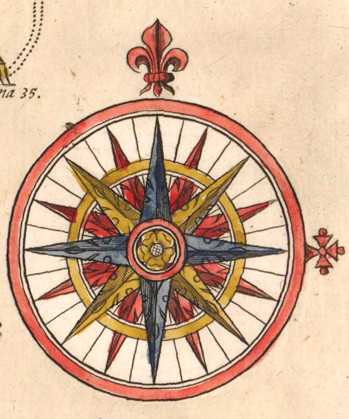
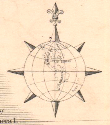
Decorations on Compass Roses Although some Portolan charts merely depicted intersecting rhumb lines without a compass rose, many included decorative and elaborate roses. Some were simple, labeled with the initials of the 8 major winds in the mariner's lingua franca, with a "T" (for Tramontana) indicating North. Since North was the cardinal direction to which the magnetic needle pointed, it was prominently depicted on maps. The first compass roses depicted north as an arrow, spearhead, triangle, or trident (all reminiscent of the pointer of the magnetic needle) or as a star to represent the North Star. It wasn't until several hundred years later that the fleur-de-lis began to symbolize North on compass roses. First seen on Portuguese charts around 1500, the fleur-de-lis bore multiple meanings: religious, as a Christian symbol of Jesus and his Mother Mary; and political, as a symbol of nobility and royalty throughout Europe. The fleur-de-lis therefore unified both spiritual and geographical symbolism, and soon became the predominant depiction of North on the compass rose.
For Portolan chartmakers in the Mediterranean, East also bore special meaning, as it indicated the direction towards Jerusalem and the Holy Land. As a result, East was often depicted with a cross. The symbol varied greatly among cartographers, taking the form of a Greek cross, a Maltese cross, a Latin cross or a cross pattee. Interestingly, the easterly pointing cross can occasionally be found on maps depicting regions east of the Holy Land. Many early maps were oriented with East at the top, such as the mappaemundi of European monasteries, and it wasn't until nearly the 19th century that depicting maps with North at the top became the standard.
Compass roses could be quite basic with only 4 directions, but more commonly were depicted with 8, 16 or 32 points to serve as more precise guides for navigators. Color was also used to aid in navigation and helped distinguish between the different points on the compass, which was particularly useful on swaying ships with only low candle light available. On Portolan charts, black was used to identify the 8 principal winds, green (and less commonly blue) for the 8 half-winds, and red for the quarter winds. In addition to cartouches, compass roses were among the first map elements to be lavishly embellished. Compass roses could be decorated with flowers at the center, and in a few examples with miniature ships, armillary spheres or even the Virgin Mary. The points of the rose were often patterned, and radiating rhumb lines were very common except in cases in which they interfered with the depiction of land.
For hundreds of years, compass roses were a fundamental and instrumental part of charts and maps. They assisted chartmakers in their drawings, aided mariners in navigating through open water, and served as a focal point to differentiate and highlight the artistic talents of cartographers. The unique attribute of the compass rose was that it could be a decorative element on a map while still serving a geographical purpose.
At the end of the Renaissance however, the compass rose began to disappear on maps and was replaced by lines of longitude and latitude. Maps became more functional and less decorative. Today, compass roses can still be found on some nautical charts, depicted with two concentric rings. The outside ring indicates true cardinal directions, while the inner ring denotes magnetic cardinal directions. These modern compass roses have evolved, but no longer feature the ornate embellishments of their predecessors. However, as long as Portolan charts and antique maps continue to be collected and examined, the fascinating origin and history of the compass rose will be preserved.
Bibliography Blake, John, The Sea Chart, Knickerbocker Press, Edison, New Jersey, 2004.
Faricic, Josip, Compass Roses on the Old Maps, Department of Geography, University of Zadar, 15 April 2013, <http://www.kartografija.hr/tl_files/Hkd/dogadjaji/kARTografija/prezentacije/Faricic.pdf> [accessed 8 July 2014].
Pflederer, Richard, Finding their Way at Sea, Hes & de Graaf Publishers, Houten, Netherlands, 2012.
Reinhartz, Dennis, The Art of the Map, Sterling Publishing, New York, 2012.
A Short History of the Compass Development, Compass Museum, <http://compassmuseum.com/diverstext/history.htm> [accessed 8 July 2014].
Thompson, Silvanus P., The Rose of the Winds: the Origin and Development of the Compass-Card, Oxford University Press, London, 1913.