Current Auction
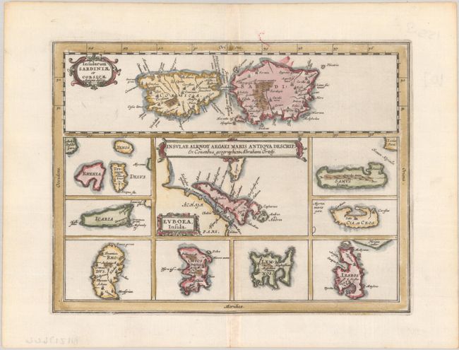
"Insular Aliquot Aegaei Maris Antiqua Descrip. Ex Conatibus Geographicis Abrahami Ortely", Cluver/Jansson
Subject: Mediterranean Islands
Period: 1676 (published)
Publication: Introductionis in Universam Geographiam
Color: Hand Color
Size:
8.2 x 6.2 inches
20.8 x 15.7 cm
Download High Resolution Image
(or just click on image to launch the Zoom viewer)
(or just click on image to launch the Zoom viewer)
This small map of Mediterranean islands is based in part on Ortelius. The central map describes the Greek island Euboea and is surrounded by nine maps of other islands. This composition includes the islands of Sardinia and Corsica [Insularum Sardiniae et Corsicae Antiquadeferm] at top instead of Cyprus, as on Ortelius' map. Three cartouches adorn the map.
Cluver's Introductio in Universam Geographicam was a popular atlas, appearing in over 45 editions during a 100-year period. The first edition was published without maps in the 1620s, and the first edition to include maps was published circa 1641. The various editions were published in different cities throughout Europe, including Amsterdam, Nuremberg, and London, often with new sets of maps engraved. This map is from an Amsterdam edition published by Jansson's heirs, which included some maps from the Jansson and Cloppenburgh editions of Atlas Minor.
References: Shirley (BL Atlases) T.CLUV-6a #24.
Condition: A
A dark impression on a bright sheet with minor toning along the centerfold and edges of the sheet.
Estimate: $110 - $140
Price: $80
Bid Increments
$50 - $99$5
$100 - $249$10
$250 - $499$25
$500 - $999$50
Terms & Conditions