Current Auction
Rare First State with Henricus Hondius Imprint
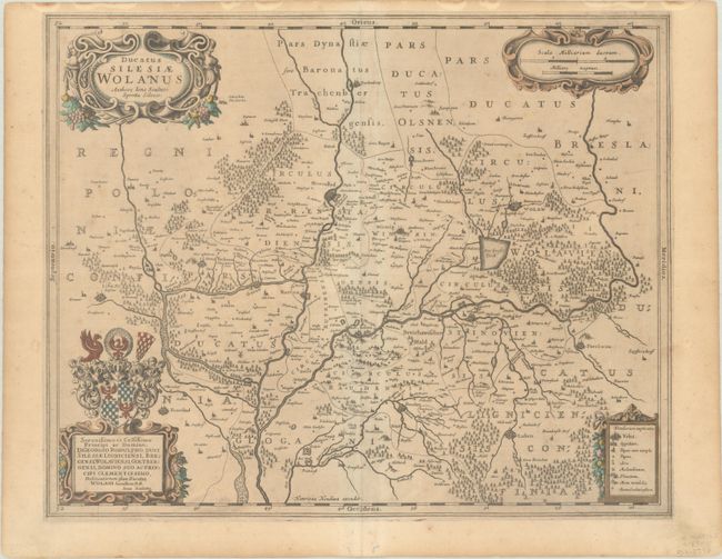
"Ducatus Silesiae Wolanus Authore Iona Sculteto Sprotta Silesio", Hondius, Henricus
Subject: Southwestern Poland
Period: 1630 (circa)
Publication:
Color: Hand Color
Size:
19.1 x 15.4 inches
48.5 x 39.1 cm
Download High Resolution Image
(or just click on image to launch the Zoom viewer)
(or just click on image to launch the Zoom viewer)
This fine decorative map shows the region around Lubin and Wolow based on the Silesian cartographer, Jonas Scultetus. The map is oriented with north to the left and shows the confluence of the Oder and Barycz Rivers. It is fully engraved with forests, rivers, lakes, and tiny villages. Cartouches fill three corners of the map, including one topped with an ornate coat of arms that includes a dedication to George Rudolf of Liegnitz, Duke of Silesia. Blank verso.
This is the first state of this map, bearing Henricus Hondius' imprint; Jan Jansson replaced the imprint with his own around 1640. Koeman's Atlantes Neerlandici lists this map only with Jan Jansson's imprint, so examples with Henricus Hondius' imprint were likely included in composite atlases and are quite rare.
References: cf. Van der Krogt (Vol. I) #2925:1.
Condition: B+
A nice impression on a lightly toned sheet with faint foxing and a pair of small worm tracks in the bottom margin.
Estimate: $200 - $230
Price: $150
Bid Increments
$100 - $249$10
$250 - $499$25
$500 - $999$50
$1,000 - $2,499$100
Terms & Conditions