Current Auction
"Environs, de Dunquerke, de, Furnes, et de Nieuport...", Fer, Nicolas de
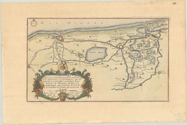
Subject: Northern France & Western Belgium
Period: 1705 (published)
Publication: Les Forces de l'Europe…
Color: Hand Color
Size:
12.4 x 7.4 inches
31.5 x 18.8 cm
Download High Resolution Image
(or just click on image to launch the Zoom viewer)
(or just click on image to launch the Zoom viewer)
Nicolas de Fer held the title of geographer at Louis XIV's court. He was one of the most prolific publishers of plans of European cities in the late seventeenth century. The fortifications plans in Les Forces de l'Europe were designed to teach fortification techniques. Engraved by Van Loon and Schoonebeek after French engineers under the command of Vauban, the renowned military architect. The illustrations often include a description and a legend with the principal buildings; each city plan includes both fortifications and street layout.
This fine chart displays the vicinity of Dunkirk and Nieuwpoort on the France/Belgium border. The map provides an excellent view of the rivers, lakes and canals, and the many fortifications in the region. It is embellished with an ornate title cartouche. Nicolas de Fer held the title of Geographer at Louis XIV's court. He was one of the most prolific publishers of plans of European cities in the late seventeenth century.
References: Pastoureau, FER IX [154].
Condition: A
A nice impression on a sheet with a bunch of grapes watermark. There is minor toning and soiling.
Estimate: $100 - $130
Price: $75
Bid Increments
$50 - $99$5
$100 - $249$10
$250 - $499$25
$500 - $999$50
Terms & Conditions